
Texas Winter 2014-2015
Moderator: S2k Moderators
Forum rules
 The posts in this forum are NOT official forecast and should not be used as such. They are just the opinion of the poster and may or may not be backed by sound meteorological data. They are NOT endorsed by any professional institution or STORM2K.

The posts in this forum are NOT official forecast and should not be used as such. They are just the opinion of the poster and may or may not be backed by sound meteorological data. They are NOT endorsed by any professional institution or STORM2K.
-
orangeblood
- S2K Supporter

- Posts: 3895
- Joined: Tue Dec 15, 2009 6:14 pm
- Location: Fort Worth, TX
Re: Texas Winter 2014-2015
For entertainment purposes only but also to show the potential of this pattern if all the pieces come together....latest GFS P Meteogram for DFW. Almost 9-10 inches of sleet and snow by New Years Day...very confident that the cold will be there, but need the models to trend back towards cutting off some of the Upper Level energy out towards Northern Mexico and we should have our storm.
0 likes

ENS means (JB's twitter). Would mean a good freeze down to LRGV. McFarland's purpose for his paper. i think going by the average of all models, it appears the first cold front passes by this weekend and hangs around with a deep polar air mass before the Arctic front plunges as HP begins bleeding down the rockies.

By Friday the first ridging will develop over the EPO domain, then the domino's fall. The events that transpires will probably resemble what happened last December and Feb 2011. At least at the 500mb level.
By Friday the first ridging will develop over the EPO domain, then the domino's fall. The events that transpires will probably resemble what happened last December and Feb 2011. At least at the 500mb level.
0 likes
The above post and any post by Ntxw is NOT an official forecast and should not be used as such. It is just the opinion of the poster and may or may not be backed by sound meteorological data. It is NOT endorsed by any professional institution including Storm2k. For official information, please refer to NWS products.
Help support Storm2K!
-
Rgv20

- S2K Supporter
- Posts: 2466
- Age: 39
- Joined: Wed Jan 05, 2011 5:42 pm
- Location: Edinburg/McAllen Tx
The JMA has a 1055 High pressure center in Colorado by Monday Morning....Looks like this Arctic Front is going to be a strong one! GFS and Euro have been flipping back and forth in regards to temps for Deep South Texas but looking at the 500mb pattern setting up Freezing temperatures are likely for the RGV come New Years and the couple of days after.
12zJMA 500mb forecast Monday Morning..
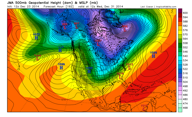
12zJMA 500mb forecast Monday Morning..

0 likes
The following post is NOT an official forecast and should not be used as such. It is just the opinion of the poster and may or may not be backed by sound meteorological data. It is NOT endorsed by any professional institution including storm2k.org For Official Information please refer to the NHC and NWS products.
-
TheProfessor

- Professional-Met

- Posts: 3506
- Age: 29
- Joined: Tue Dec 03, 2013 10:56 am
- Location: Wichita, Kansas
-
Portastorm

- Storm2k Moderator

- Posts: 9955
- Age: 63
- Joined: Fri Jul 11, 2003 9:16 am
- Location: Round Rock, TX
- Contact:
Re: Texas Winter 2014-2015
Interesting thoughts this evening from Houston-area pro met and Storm 2K member Jeff Lindner:
Clear but cool Christmas…arctic outbreak and possible winter storm looms in the extended.
Potent storm system moved across the region this morning with a quick round of showers and even a few thunderstorms. Cold air advection continues this evening and on into Wednesday with clearing skies. Winds will keep temperatures from bottoming out tonight…mainly in the 40’s with highs only in the mid 50’s on Wednesday. Coldest night comes Wednesday into Christmas morning with mid 30’s and likely some lower 30’s over portions of the area under clear skies and light winds.
Christmas Day:
Surface high responsible for the current intrusion of cold air begins to move eastward on Thursday allowing onshore flow to resume. Cold start under clear skies will feature a good warm up into the lower 60’s for highs helped by sun and southerly flow.
Friday:
Probably the best day of the week temperature wise with lows in the 40’s and highs near 70 under increasing southerly flow. Clouds will start to increase ahead of a storm system for the weekend.
Weekend:
Next storm system will move across in the fast progressive flow aloft. Cold surface dome will only slowly modify and expect clouds and light rain to increase Saturday with the old surface front from today remaining offshore. A round of fog, drizzle, light rain seems likely Saturday and Sunday as the next system moves across and the surface cold pool hangs tough over the area. Models have been trending wetter and wetter with this system especially on Sunday so rain chances may need to be increased into the 60-70% range. Temperatures will be cool with both highs and lows regulated by clouds and rainfall to the 50’s and 40’s.
Next Week:
Upper air flow undergoes significant amplification with strong ridging building deep into Alaska resulting in the formation of a deep downstream longwave trough over the western and central US. Extremely cold air mass now of Siberia and northern Russia (-70 F wind chill today) will become entrained into the flow aloft and progress into NW Canada (the favored source region for US arctic air outbreaks) featuring temperatures in the -30 to -40F by the early to middle part of next week. With the trough in place over the western and central US, the arctic air begins to roar southward under the influence of a 1045-1055mb arctic surface ridge entering the US via Montana. The dense very cold air dams against the Rockies and spills southward straight down the front range into TX at a very rapid pace. True shallow arctic air masses almost always outrun model guidance and I think this event will be no different. Models are also almost always too warm with the air mass and undergo run to run temperature decreases as the event nears in the 48 hour time period. Don’t think we are looking at anything historic or record breaking with respect to the cold air, but a period of freezing and sub freezing temperatures is looking increasingly likely from as early as the 31st through the 2nd or even 3rd of Jan and this could include near freezing daytime highs. Intensity of the cold air is still subject of model disagreement, but once arctic air starts moving southward it is hard to stop it and the pattern certainly supports this.
Next and perhaps the bigger question is will there be any moisture in the post frontal arctic air. Forecast models have been off and on suggesting a portion of the upper trough hangs back over the SW US with a upper level flow out of the SW over the surface arctic air mass in place over TX. This would produce an overrunning pattern with warm air flow up and over the surface cold dome. Upper disturbances in this upper flow would help to enhance lift from time to time producing periods of precipitation. Long range forecast soundings show mostly a surface freezing layer with temperatures above freezing in the mid levels. P-type could be a potential issue from late on the 31st into the 2nd with the mostly likely precipitation being rain or freezing rain with the current suggested profiles. A fairly significant winter storm pattern is being suggested by the forecast models for the state of TX during this time period, but given how far out in time we are the fine details are beyond the limits of any forecasting certainty and more speculation. Much attention to be paid to this part of the forecast over the next several days.
0 likes
Any forecasts under my name are to be taken with a grain of salt. Get your best forecasts from the National Weather Service and National Hurricane Center.
-
CYCLONE MIKE
- Category 5

- Posts: 2183
- Joined: Tue Aug 31, 2004 6:04 pm
- Location: Gonzales, LA
I'm leaning towards this potential event being all or nothing. It seems the gfs is either showing cold and winter precip for tx and LA or cold and dry. Hasn't shown anything in between but maybe a run or two that shows warm and wet. Think we will get the cold but will it be cold enough and obviously the biggest question will be... Will we get a disturbance or low to form along the tx coast and move ne to throw moisture back our way or will it all be suppressed well south into the gulf?
0 likes

Re:
Ntxw wrote:Emphasis on for entertainment only purely for the HP value. Anyway the modelling shifts back and forth seems to be from the MJO vs EPO. Whichever one the model likes then the solution it shows. Either way, still arctic air is coming that idea hasn't changed post Christmas. The dominant block on all guidance is still the EPO which we know is the cold loader.
http://i60.tinypic.com/34payo1.gif
I see a 1064 millibar high pressure. That is strong. Not surprise it will change.
Last edited by Ptarmigan on Tue Dec 23, 2014 11:00 pm, edited 1 time in total.
0 likes
Re: Texas Winter 2014-2015
aggiecutter wrote:
The 500mb flow is not 62-83, or 89. It is much more conducive to a January-February 78 type of pattern.
ronyan wrote::uarrow:
The CPC analogs for 8-14 days have late dec 1977, but 1983 is also in the list.
January-February 1978 was very cold for sure.


0 likes
Re: Texas Winter 2014-2015
The 0z GFS and PGFS both have 1050+ mb highs in Colorado @ 180 hrs. The parallel run looks brutal for N TX on the surface, -20C anomalies showing up in the panhandle, further North approaching 30C below normal

Last edited by ronyan on Wed Dec 24, 2014 12:35 am, edited 1 time in total.
0 likes
-
Rgv20
- S2K Supporter
- Posts: 2466
- Age: 39
- Joined: Wed Jan 05, 2011 5:42 pm
- Location: Edinburg/McAllen Tx
MERRY CHRISTMAS PORTA!!  I think the 0zGFS Parallel went a bit overboard with the snowfall......
0zGFS Parallel Total Snowfall January 2..
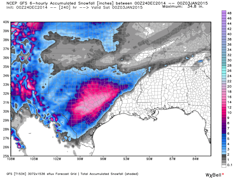
Closer look...pretty impressive!
0zGFS Parallel Total Snowfall January 2..

Closer look...pretty impressive!

0 likes
The following post is NOT an official forecast and should not be used as such. It is just the opinion of the poster and may or may not be backed by sound meteorological data. It is NOT endorsed by any professional institution including storm2k.org For Official Information please refer to the NHC and NWS products.
Re: Texas Winter 2014-2015
Those accumulated snowfall maps seem to be of little value other than for entertainment purposes, but that's one of the more extreme I've seen for TX. 16 inches of snow on the ground in Austin, yeah that's common.
Last edited by ronyan on Wed Dec 24, 2014 12:41 am, edited 2 times in total.
0 likes
-
Brent
- S2K Supporter
- Posts: 38750
- Age: 37
- Joined: Sun May 16, 2004 10:30 pm
- Location: Tulsa Oklahoma
- Contact:
Re: Texas Winter 2014-2015
HAHA even if you cut those totals down 75% I'd be a happy man LOL
0 likes
#neversummer
-
CYCLONE MIKE
- Category 5
- Posts: 2183
- Joined: Tue Aug 31, 2004 6:04 pm
- Location: Gonzales, LA
Re:
BigB0882 wrote:That kind of snowfall can't happen in Texas unless y'all send it over to all of LA after you are done with it.
That's about right B. They will get that snow while we get an all day rain at 34* with a few rogue sleet pellets mixed in.
0 likes
-
orangeblood
- S2K Supporter
- Posts: 3895
- Joined: Tue Dec 15, 2009 6:14 pm
- Location: Fort Worth, TX
Re: Texas Winter 2014-2015
Although extreme, at least the GFS P is showing some run to run consistency haha. GEFS is now on board with the southwest US solution as well. Crazy Canadian is dry/cool northwest flow. Now, which way will the Euro lean ?
0 likes
-
CYCLONE MIKE
- Category 5
- Posts: 2183
- Joined: Tue Aug 31, 2004 6:04 pm
- Location: Gonzales, LA
Re: Texas Winter 2014-2015
Wouldn't surprise me in the least if it does the exact opposite and shows no cold at all and dry as a bone
Just don't want it to show snow anywhere around LA cause every time it did last year we got nothing but ice.
Just don't want it to show snow anywhere around LA cause every time it did last year we got nothing but ice.
0 likes
-
Rgv20
- S2K Supporter
- Posts: 2466
- Age: 39
- Joined: Wed Jan 05, 2011 5:42 pm
- Location: Edinburg/McAllen Tx
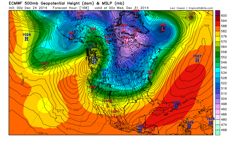
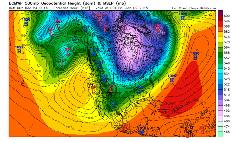
Thru 7 days the 0zECMWF looks familiar at the 500mb pattern to the 0zGFS.....Look at that 1055mb High!

0 likes
The following post is NOT an official forecast and should not be used as such. It is just the opinion of the poster and may or may not be backed by sound meteorological data. It is NOT endorsed by any professional institution including storm2k.org For Official Information please refer to the NHC and NWS products.
-
Rgv20
- S2K Supporter
- Posts: 2466
- Age: 39
- Joined: Wed Jan 05, 2011 5:42 pm
- Location: Edinburg/McAllen Tx
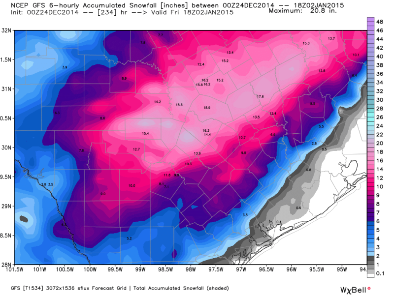
Re: Texas Winter 2014-2015
orangeblood I'm I seeing double??
0zECMWF forecast for New Years day afternoon.. The Euro is forecast 3-4 inches of Snow in the RGV!
Christmas Eve 2004

0zECMWF forecast for New Years day afternoon..

Christmas Eve 2004
0 likes
The following post is NOT an official forecast and should not be used as such. It is just the opinion of the poster and may or may not be backed by sound meteorological data. It is NOT endorsed by any professional institution including storm2k.org For Official Information please refer to the NHC and NWS products.
-
Ralph's Weather
- S2K Supporter
- Posts: 3371
- Age: 38
- Joined: Fri Dec 13, 2013 11:55 am
- Location: Lindale, TX
- Contact:
From what I am seeing posted it looks like the 0Z runs all agree with the idea of a southwestern low and a huge high. If those two things happen we will have a major winter storm I just hope it is a snow storm and not sleet or freezing rain. Still a long way to go.
0 likes
Follow on Facebook at Ralph's Weather.
-
Ralph's Weather
- S2K Supporter
- Posts: 3371
- Age: 38
- Joined: Fri Dec 13, 2013 11:55 am
- Location: Lindale, TX
- Contact:
Who is online
Users browsing this forum: No registered users and 85 guests