ENSO Updates (2007 thru 2023)
Moderator: S2k Moderators
Forum rules

The posts in this forum are NOT official forecasts and should not be used as such. They are just the opinion of the poster and may or may not be backed by sound meteorological data. They are NOT endorsed by any professional institution or STORM2K. For official information, please refer to products from the National Hurricane Center and National Weather Service.
-
xtyphooncyclonex

- Category 5

- Posts: 3891
- Age: 24
- Joined: Sat Dec 08, 2012 9:07 am
- Location: Cebu City
- Contact:
It has been 10 weeks straight El Niño conditions longer than 2012's 9 weeks
0 likes
REMINDER: My opinions that I, or any other NON Pro-Met in this forum, are unofficial. Please do not take my opinions as an official forecast and warning. I am NOT a meteorologist. Following my forecasts blindly may lead to false alarm, danger and risk if official forecasts from agencies are ignored.
-
cycloneye

- Admin

- Posts: 149514
- Age: 69
- Joined: Thu Oct 10, 2002 10:54 am
- Location: San Juan, Puerto Rico
Re:
xtyphooncyclonex wrote:It has been 10 weeks straight El Niño conditions longer than 2012's 9 weeks
But still the atmosphere is not cooperating to make it official.Let's see what CPC says on January 8.
0 likes
Visit the Caribbean-Central America Weather Thread where you can find at first post web cams,radars
and observations from Caribbean basin members Click Here
and observations from Caribbean basin members Click Here
-
cycloneye
- Admin
- Posts: 149514
- Age: 69
- Joined: Thu Oct 10, 2002 10:54 am
- Location: San Juan, Puerto Rico
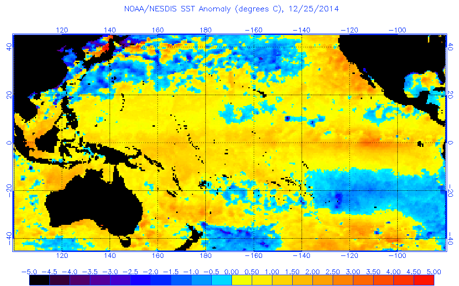
Re: ENSO: CPC 12/22/14 update=Nino 3.4 remains at +0.8C
The 7-day change graphic shows how the cooling is doing.

0 likes
Visit the Caribbean-Central America Weather Thread where you can find at first post web cams,radars
and observations from Caribbean basin members Click Here
and observations from Caribbean basin members Click Here
-
xtyphooncyclonex
- Category 5
- Posts: 3891
- Age: 24
- Joined: Sat Dec 08, 2012 9:07 am
- Location: Cebu City
- Contact:
Re: Re:
cycloneye wrote:xtyphooncyclonex wrote:It has been 10 weeks straight El Niño conditions longer than 2012's 9 weeks
But still the atmosphere is not cooperating to make it official.Let's see what CPC says on January 8.
Oh yeah
The atmospheric index went down [ENSO] probably because of some clusters of clouds over Southeast Asia. In El Niño events, it is supposedly reverse. But yeah, we have to wait and see.
0 likes
REMINDER: My opinions that I, or any other NON Pro-Met in this forum, are unofficial. Please do not take my opinions as an official forecast and warning. I am NOT a meteorologist. Following my forecasts blindly may lead to false alarm, danger and risk if official forecasts from agencies are ignored.
-
cycloneye
- Admin
- Posts: 149514
- Age: 69
- Joined: Thu Oct 10, 2002 10:54 am
- Location: San Juan, Puerto Rico
Re: ENSO Updates
The Aussies say El Nino is very close to be declared. if you read between the lines.
Near El Niño conditions persist in tropical Pacific Ocean
Issued on 23 December 2014 | Product Code IDCKGEWW00
The tropical Pacific Ocean continues to border on El Niño thresholds, with rainfall patterns around the Pacific Ocean basin, and at times further afield, displaying El Niño-like patterns over recent months.
Indicators remain broadly consistent with borderline El Niño conditions. Sea surface temperatures have exceeded thresholds for a number of weeks, and the Southern Oscillation Index (SOI) has generally been negative for the past few months. Trade winds have been near-average along the equator, but weaker in the broader tropical belt. Together, these indicate some weak coupling of the atmosphere and ocean may be occuring.
Climate models expect little change over the next two to three months, with most predicting a persistence of the current warm sea surface temperatures. If current conditions do persist or strengthen into next year, 2014–15 is likely to be considered a weak El Niño. As a result, the Bureau's ENSO Tracker status remains at ALERT.
http://www.bom.gov.au/climate/enso/
0 likes
Visit the Caribbean-Central America Weather Thread where you can find at first post web cams,radars
and observations from Caribbean basin members Click Here
and observations from Caribbean basin members Click Here

Re: ENSO Updates
SOI has been crashing for the last few of days, back down to El Nino threshold.
https://www.longpaddock.qld.gov.au/seas ... tionindex/
Code: Select all
SOI values for 24 Dec 2014


Average for last 30 days
-8.5

Average for last 90 days
-7.5

Daily contribution to SOI calculation
-38.6
https://www.longpaddock.qld.gov.au/seas ... tionindex/
0 likes
-
cycloneye
- Admin
- Posts: 149514
- Age: 69
- Joined: Thu Oct 10, 2002 10:54 am
- Location: San Juan, Puerto Rico
Re: ENSO Updates
Let's see if this SOI crash helps to push the El Nino declaration to fructition on January 8 unless something gets in the way like (Atmosphere still doesn't cooperate) and disrupts that.
0 likes
Visit the Caribbean-Central America Weather Thread where you can find at first post web cams,radars
and observations from Caribbean basin members Click Here
and observations from Caribbean basin members Click Here
-
Kingarabian

- S2K Supporter

- Posts: 16367
- Joined: Sat Aug 08, 2009 3:06 am
- Location: Honolulu, Hawaii
-
cycloneye
- Admin
- Posts: 149514
- Age: 69
- Joined: Thu Oct 10, 2002 10:54 am
- Location: San Juan, Puerto Rico
Re: ENSO Updates
Now what? Modoki,Traditional or no El Nino? Nino 3.4 poised to fall below +0.5C and Nino 1+2 drops to La Nina territory 
Nino 1+2

Nino 3

Nino 3.4

Nino 4

Nino 1+2
Nino 3
Nino 3.4
Nino 4
0 likes
Visit the Caribbean-Central America Weather Thread where you can find at first post web cams,radars
and observations from Caribbean basin members Click Here
and observations from Caribbean basin members Click Here

Re:
Kingarabian wrote:So the SOI is not the atmosphere barometer?
Technically, not completely- the SOI is not directly what "drives" the ocean's response to the atmosphere in the context of an el nino. This is because the SOI is determined by atmospheric conditions south of the equator and not directly on the equator itself. The true "pressure type reading" that you are asking about is the ESOI - the Equatorial Southern Oscillation Index-which is analogous to the SOI- but calculated using atmospheric pressures on the equator itself. The ESOI and SOI are -of course - correlated to each other, but they are not the same. Although SOI values have been fairly negative for the past several months - the ESOI index still hovers around 0.
For the atmosphere to be considered "fully coupled" to the ocean in the context of an el nino, there needs to a robust atmospheric response on the equator itself. This can be indicated by diminished equatorial trade winds over the nino3.4 region, enhanced convection/rainfall on the equator near the dateline and suppressed rainfall over indonesia-neither have been observed.
0 likes
All posts by Dean_175 are NOT official forecasts and should not be used as such. They are just the opinion of the poster and may or may not be backed by sound meteorological data. They are NOT endorsed by any professional institution or storm2k.org. For official information, please refer to the NHC and NWS products.
-
cycloneye
- Admin
- Posts: 149514
- Age: 69
- Joined: Thu Oct 10, 2002 10:54 am
- Location: San Juan, Puerto Rico
Re: Re:
Dean_175 wrote:Kingarabian wrote:So the SOI is not the atmosphere barometer?
Technically, no- the SOI is not directly what "drives" the ocean's response to the atmosphere in the context of an el nino. This is because the SOI is determined by atmospheric conditions south of the equator and not directly on the equator itself. The true "pressure type reading" that you are asking about is the ESOI - the Equatorial Southern Oscillation Index-which is analogous to the SOI- but calculated using atmospheric pressures on the equator itself. The ESOI and SOI are -of course - correlated to each other, but they are not the same. Although SOI values have been fairly negative for the past several months - the ESOI index still hovers around 0.
For the atmosphere to be considered "fully coupled" to the ocean in the context of an el nino, there needs to a robust atmospheric response on the equator itself. This can be indicated by diminished equatorial trade winds over the nino3.4 region, enhanced convection/rainfall on the equator near the dateline and suppressed rainfall over indonesia-neither have been observed.
Welcome to the ENSO thread. These kind of discussions is what I want to see to help those who may not know a lot about how ENSO works. So if this atmosphere disconnection continues there wont be El Nino after all with the implications that may have down the road on the weather in North America and the tropics next summer.
0 likes
Visit the Caribbean-Central America Weather Thread where you can find at first post web cams,radars
and observations from Caribbean basin members Click Here
and observations from Caribbean basin members Click Here
-
cycloneye
- Admin
- Posts: 149514
- Age: 69
- Joined: Thu Oct 10, 2002 10:54 am
- Location: San Juan, Puerto Rico
Re: ENSO Updates: All Nino areas cooling down
The graphics I posted earlier have been updated and they are plunging further.Nino 3.4 falls below +0.5C for the first time since late October.See first post of thread
0 likes
Visit the Caribbean-Central America Weather Thread where you can find at first post web cams,radars
and observations from Caribbean basin members Click Here
and observations from Caribbean basin members Click Here
-
xtyphooncyclonex
- Category 5
- Posts: 3891
- Age: 24
- Joined: Sat Dec 08, 2012 9:07 am
- Location: Cebu City
- Contact:
Actually, the cooling should stop a bit. There is some warming underneath Nino 3.4
0 likes
REMINDER: My opinions that I, or any other NON Pro-Met in this forum, are unofficial. Please do not take my opinions as an official forecast and warning. I am NOT a meteorologist. Following my forecasts blindly may lead to false alarm, danger and risk if official forecasts from agencies are ignored.
-
xtyphooncyclonex
- Category 5
- Posts: 3891
- Age: 24
- Joined: Sat Dec 08, 2012 9:07 am
- Location: Cebu City
- Contact:
Anyhow, the cooling is consistently predicted by the CFSv2 which shows afterwards some substantial warming. Nothing to raise an eyebrow on
Last edited by xtyphooncyclonex on Fri Dec 26, 2014 4:44 am, edited 1 time in total.
0 likes
REMINDER: My opinions that I, or any other NON Pro-Met in this forum, are unofficial. Please do not take my opinions as an official forecast and warning. I am NOT a meteorologist. Following my forecasts blindly may lead to false alarm, danger and risk if official forecasts from agencies are ignored.
-
somethingfunny

- ChatStaff

- Posts: 3926
- Age: 37
- Joined: Thu May 31, 2007 10:30 pm
- Location: McKinney, Texas
Re: ENSO Updates: PDO goes up to +1.72
euro6208 wrote:
WOW! Super El nino


I hope this happens.
0 likes
I am not a meteorologist, and any posts made by me are not official forecasts or to be interpreted as being intelligent. These posts are just my opinions and are probably silly opinions.
-
cycloneye
- Admin
- Posts: 149514
- Age: 69
- Joined: Thu Oct 10, 2002 10:54 am
- Location: San Juan, Puerto Rico
Re: ENSO Updates: All Nino areas cooling down
The queston is after the crash is over how much warming will occur because wow,Nino 1+2 is now well in La Nina threshold and Nino 3.4 is more and more away from +0.5C as I type this post.
0 likes
Visit the Caribbean-Central America Weather Thread where you can find at first post web cams,radars
and observations from Caribbean basin members Click Here
and observations from Caribbean basin members Click Here
-
euro6208
Re: ENSO Updates: All Nino areas cooling down
All ninos cooling down due to strong MJO moving through the Pacific Basin...It's only december...This should strengthen majorly as we head towards the 2nd half of 2015...
0 likes
-
cycloneye
- Admin
- Posts: 149514
- Age: 69
- Joined: Thu Oct 10, 2002 10:54 am
- Location: San Juan, Puerto Rico
Re: ENSO Updates: All Nino areas cooling down
If and is a huge if right now El Nino comes it would be a Modoki one as Nino 1+2 has crashed to very La Nina threshold.
Data as of 06z:
Nino 1+2=In La Nina threshold -0.828C
Nino 3=Barely in El Nino threshold+0.504C
Nino 3.4=In Neutral at +0.416C
Nino 4=Is always above +0.5C Now at +0.838C
Data as of 06z:
Nino 1+2=In La Nina threshold -0.828C
Nino 3=Barely in El Nino threshold+0.504C
Nino 3.4=In Neutral at +0.416C
Nino 4=Is always above +0.5C Now at +0.838C
0 likes
Visit the Caribbean-Central America Weather Thread where you can find at first post web cams,radars
and observations from Caribbean basin members Click Here
and observations from Caribbean basin members Click Here
-
cycloneye
- Admin
- Posts: 149514
- Age: 69
- Joined: Thu Oct 10, 2002 10:54 am
- Location: San Juan, Puerto Rico
Re: ENSO Updates: All Nino areas cooling down
As long the ESPI:-0.68 continues way in negative,is another sign towards no El Nino.
0 likes
Visit the Caribbean-Central America Weather Thread where you can find at first post web cams,radars
and observations from Caribbean basin members Click Here
and observations from Caribbean basin members Click Here
Who is online
Users browsing this forum: No registered users and 127 guests