
Texas Winter 2014-2015
Moderator: S2k Moderators
Forum rules
 The posts in this forum are NOT official forecast and should not be used as such. They are just the opinion of the poster and may or may not be backed by sound meteorological data. They are NOT endorsed by any professional institution or STORM2K.

The posts in this forum are NOT official forecast and should not be used as such. They are just the opinion of the poster and may or may not be backed by sound meteorological data. They are NOT endorsed by any professional institution or STORM2K.
-
Rgv20

- S2K Supporter

- Posts: 2466
- Age: 39
- Joined: Wed Jan 05, 2011 5:42 pm
- Location: Edinburg/McAllen Tx
12zGFS depicts a 1040+mb High just north of the Panhandle by Wednesday Morning and a strong upper level low in Arizona...Strong Arctic front coming down folks!

0 likes
The following post is NOT an official forecast and should not be used as such. It is just the opinion of the poster and may or may not be backed by sound meteorological data. It is NOT endorsed by any professional institution including storm2k.org For Official Information please refer to the NHC and NWS products.
-
Portastorm

- Storm2k Moderator

- Posts: 9955
- Age: 63
- Joined: Fri Jul 11, 2003 9:16 am
- Location: Round Rock, TX
- Contact:
Re: Texas Winter 2014-2015
Perv12z GFS, precip starts breaking out New Years Eve morning in south Texas and spreads north throughout the day. But what's really interesting is how it progs a longer duration event than in previous runs. Definitely raises an eyebrow.
0 likes
Any forecasts under my name are to be taken with a grain of salt. Get your best forecasts from the National Weather Service and National Hurricane Center.

Re: Texas Winter 2014-2015
Just by the gfs progs way out, it looks like ice storm for a large swath underneath arctic front. Deeper cold is hanging in the northwest half of the state. But those are details that will change so far out. Quite possible someone will get an ice storm somewhere.
0 likes
The above post and any post by Ntxw is NOT an official forecast and should not be used as such. It is just the opinion of the poster and may or may not be backed by sound meteorological data. It is NOT endorsed by any professional institution including Storm2k. For official information, please refer to NWS products.
Help support Storm2K!
-
wxman57

- Moderator-Pro Met

- Posts: 23174
- Age: 68
- Joined: Sat Jun 21, 2003 8:06 pm
- Location: Houston, TX (southwest)
Re: Texas Winter 2014-2015
12Z GFS keeps the sub-freezing air north of the Gulf Coast on the 31st-1st. No snow for the coast. It's probably under-forecasting the southward movement of the Arctic air, as is typical in such cases. The main question is whether or not the upper trof will move across Texas once the cold air is in place.
0 likes
-
Rgv20
- S2K Supporter
- Posts: 2466
- Age: 39
- Joined: Wed Jan 05, 2011 5:42 pm
- Location: Edinburg/McAllen Tx
Re: Texas Winter 2014-2015
wxman57 wrote:12Z GFS keeps the sub-freezing air north of the Gulf Coast on the 31st-1st. No snow for the coast. It's probably under-forecasting the southward movement of the Arctic air, as is typical in such cases. The main question is whether or not the upper trof will move across Texas once the cold air is in place.
We shall see what the 12zGFS Parallel shows in about 15-20 minutes as far as Forecast 2M Temperature for the 31st-1st. At least with each passing model run the only thing that its becoming clear is that a Strong Arctic Front is in the offering for all of Texas!
0 likes
The following post is NOT an official forecast and should not be used as such. It is just the opinion of the poster and may or may not be backed by sound meteorological data. It is NOT endorsed by any professional institution including storm2k.org For Official Information please refer to the NHC and NWS products.
-
TeamPlayersBlue

- Category 5

- Posts: 3530
- Joined: Tue Feb 02, 2010 1:44 am
- Location: Denver/Applewood, CO
Now lets say an HP comes down like the GFS says, surely it would be freezing to very close to the gulf coast right? Models are a bit off? The precip in this type of scenario would be hopefully similar to one of our wash out days of rain except this time with winter precip.
0 likes
Personal Forecast Disclaimer:
The posts in this forum are NOT official forecast and should not be used as such. They are just the opinion of the poster and may or may not be backed by sound meteorological data. They are NOT endorsed by any professional institution or storm2k.org. For official information, please refer to the NHC and NWS products.
The posts in this forum are NOT official forecast and should not be used as such. They are just the opinion of the poster and may or may not be backed by sound meteorological data. They are NOT endorsed by any professional institution or storm2k.org. For official information, please refer to the NHC and NWS products.

-
srainhoutx

- S2K Supporter
- Posts: 6919
- Age: 68
- Joined: Sun Jan 14, 2007 11:34 am
- Location: Haywood County, NC
- Contact:
Re: Texas Winter 2014-2015
The 12Z parallel GFS leaves a SW disturbance behind and has some chilly air in place into January 2nd. If that SW upper disturbance is there, that tends to suggest a SW flow aloft continues until the upper trough finally moves by.


0 likes
Carla/Alicia/Jerry(In The Eye)/Michelle/Charley/Ivan/Dennis/Katrina/Rita/Wilma/Ike/Harvey
Member: National Weather Association
Wx Infinity Forums
http://wxinfinity.com/index.php
Facebook.com/WeatherInfinity
Twitter @WeatherInfinity
Member: National Weather Association
Wx Infinity Forums
http://wxinfinity.com/index.php
Facebook.com/WeatherInfinity
Twitter @WeatherInfinity
-
Rgv20
- S2K Supporter
- Posts: 2466
- Age: 39
- Joined: Wed Jan 05, 2011 5:42 pm
- Location: Edinburg/McAllen Tx
12zUKMET at the end of its run (144hrs) shows a similar 500mb setup to the 12zGFS...Winter is Coming to Texas!
12zUKMET 500mb forecast valid for Tuesday Morning..
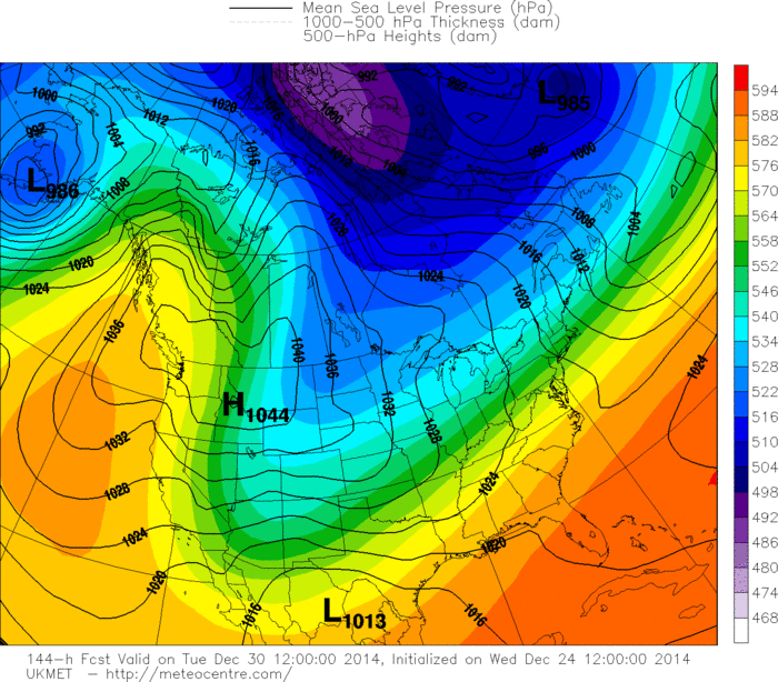
12zUKMET 500mb forecast valid for Tuesday Morning..

0 likes
The following post is NOT an official forecast and should not be used as such. It is just the opinion of the poster and may or may not be backed by sound meteorological data. It is NOT endorsed by any professional institution including storm2k.org For Official Information please refer to the NHC and NWS products.
-
TeamPlayersBlue
- Category 5
- Posts: 3530
- Joined: Tue Feb 02, 2010 1:44 am
- Location: Denver/Applewood, CO
The GFS cant be handling it well. For Sugar Land it has the lowest temps for 925 mb at 4C and 850 mb at 10C. 
0 likes
Personal Forecast Disclaimer:
The posts in this forum are NOT official forecast and should not be used as such. They are just the opinion of the poster and may or may not be backed by sound meteorological data. They are NOT endorsed by any professional institution or storm2k.org. For official information, please refer to the NHC and NWS products.
The posts in this forum are NOT official forecast and should not be used as such. They are just the opinion of the poster and may or may not be backed by sound meteorological data. They are NOT endorsed by any professional institution or storm2k.org. For official information, please refer to the NHC and NWS products.
Re: Texas Winter 2014-2015
GFS doesn't have a good grasp of the surface with these fronts, 12z has a stronger high building in Idaho than 6z but the surface is considerably warmer in SE TX on the 12z run.
Temps are difficult to forecast with arctic fronts, I like to watch the upstream temps ahead of the front as it's coming down from the North before being confident in a prediction.
Temps are difficult to forecast with arctic fronts, I like to watch the upstream temps ahead of the front as it's coming down from the North before being confident in a prediction.
Last edited by ronyan on Wed Dec 24, 2014 12:54 pm, edited 1 time in total.
0 likes
-
srainhoutx
- S2K Supporter
- Posts: 6919
- Age: 68
- Joined: Sun Jan 14, 2007 11:34 am
- Location: Haywood County, NC
- Contact:
Re: Texas Winter 2014-2015
The 12Z Canadian continues the general theme of a cold and stormy New Years Eve/New Years Day.
0 likes
Carla/Alicia/Jerry(In The Eye)/Michelle/Charley/Ivan/Dennis/Katrina/Rita/Wilma/Ike/Harvey
Member: National Weather Association
Wx Infinity Forums
http://wxinfinity.com/index.php
Facebook.com/WeatherInfinity
Twitter @WeatherInfinity
Member: National Weather Association
Wx Infinity Forums
http://wxinfinity.com/index.php
Facebook.com/WeatherInfinity
Twitter @WeatherInfinity
-
orangeblood
- S2K Supporter
- Posts: 3895
- Joined: Tue Dec 15, 2009 6:14 pm
- Location: Fort Worth, TX
Re: Texas Winter 2014-2015
12Z Crazy Canadian has a bit more sanity now, trending towards the other models further southwest solutions....this storm next week has the potential to be a very rare setup in this part of the world, a WIDESPREAD event impacting a huge part of Texas (extremely rare to get this type cold so far south with so much upper level energy/moisture hanging back to our west) ..... The stars are beginning to align, need a few more model runs to establish that a storm will be there then finer details can be ironed out this weekend.
The very conservative Canadian Model even has the storm now....

The very conservative Canadian Model even has the storm now....
0 likes
Re: Texas Winter 2014-2015
As wxman said, snow totals would probably be heavier near the coast of TX if this develops with sufficient cold air in place. I'm slightly biased, being ~5 mi from the coast. 
0 likes
-
TeamPlayersBlue
- Category 5
- Posts: 3530
- Joined: Tue Feb 02, 2010 1:44 am
- Location: Denver/Applewood, CO
Re: Texas Winter 2014-2015
orangeblood wrote:12Z Crazy Canadian has a bit more sanity now, trending towards the other models further southwest solutions....this storm next week has the potential to be a very rare setup in this part of the world, a WIDESPREAD event impacting a huge part of Texas (extremely rare to get this type cold so far south with so much upper level energy/moisture hanging back to our west) ..... The stars are beginning to align, need a few more model runs to establish that a storm will be there then finer details can be ironed out this weekend.
The very conservative Canadian Model even has the storm now....
[img]http://www.tropicaltidbits.com/analysis/models/gem/2014122412/gem_asnow_us_37.pn g[/img]
Now, of course im biased, but the Canadian temps looks about right. I think thats a good idea of what we would expect with a 1050 MB HP coming into the US. Keeps it at 1041 to about San Angelo too. Moisture wise, id expect about 12 hours or precip. Most of the time thats what we get from the these Lows that form from the STJ. Anything more than that i would be suspect. That sound fair?
Also, if it sticks around long enough, maybe three days, the STJ can reload and provide another winter precip event. Im not trying to be greedy here though.
0 likes
Personal Forecast Disclaimer:
The posts in this forum are NOT official forecast and should not be used as such. They are just the opinion of the poster and may or may not be backed by sound meteorological data. They are NOT endorsed by any professional institution or storm2k.org. For official information, please refer to the NHC and NWS products.
The posts in this forum are NOT official forecast and should not be used as such. They are just the opinion of the poster and may or may not be backed by sound meteorological data. They are NOT endorsed by any professional institution or storm2k.org. For official information, please refer to the NHC and NWS products.
-
srainhoutx
- S2K Supporter
- Posts: 6919
- Age: 68
- Joined: Sun Jan 14, 2007 11:34 am
- Location: Haywood County, NC
- Contact:
Re: Texas Winter 2014-2015
The 12Z Euro has a 1051mb Arctic High dropping S into Montana.
0 likes
Carla/Alicia/Jerry(In The Eye)/Michelle/Charley/Ivan/Dennis/Katrina/Rita/Wilma/Ike/Harvey
Member: National Weather Association
Wx Infinity Forums
http://wxinfinity.com/index.php
Facebook.com/WeatherInfinity
Twitter @WeatherInfinity
Member: National Weather Association
Wx Infinity Forums
http://wxinfinity.com/index.php
Facebook.com/WeatherInfinity
Twitter @WeatherInfinity

Is the Canadian model ever forecast correct in Canada? I would never trust it at all. This is a classic case of ridge over SE helps force cold air down the leeside of the Rockies into Texas. Lower dewpoints there help to provide good wintry precip opps, while us here in south Louisiana get the higher dewpoints which usually equate to 35 degrees and a nice cold rain and north part of LA gets in on the action. Still a week out with final details probably not determined until the event is occurring.
0 likes
Re: Texas Winter 2014-2015
In the past I've noticed set ups like this features two events. With a SW trof a piece will probably kick out ahead along the arctic front. I think this is where the biggest threat of an ice storm will be, with the SOI crash the STJ will make noise. Then when the actual upper trof kicks out usually at the back end when cold air starts to retreat is when areas further south sees wintry precip as snowcover is down up north. Just something to think about.
0 likes
The above post and any post by Ntxw is NOT an official forecast and should not be used as such. It is just the opinion of the poster and may or may not be backed by sound meteorological data. It is NOT endorsed by any professional institution including Storm2k. For official information, please refer to NWS products.
Help support Storm2K!
Help support Storm2K!
Re: Texas Winter 2014-2015
12z Euro has a huge 1054mb Arctic high in Wyoming @ 168 hrs. Cold air plunges straight South into S TX, looks like a setup where Brownsville could get the front before Houston. The horizontal temperature gradient is impressive at 850mb.
Last edited by ronyan on Wed Dec 24, 2014 2:09 pm, edited 1 time in total.
0 likes
Who is online
Users browsing this forum: No registered users and 89 guests