Texas Winter 2014-2015

Winter Weather Discussion

Moderator: S2k Moderators

Forum rules

The posts in this forum are NOT official forecast and should not be used as such. They are just the opinion of the poster and may or may not be backed by sound meteorological data. They are NOT endorsed by any professional institution or STORM2K.

Help Support Storm2K
Message
Author
User avatar
Rgv20
S2K Supporter
S2K Supporter
Posts: 2466
Age: 39
Joined: Wed Jan 05, 2011 5:42 pm
Location: Edinburg/McAllen Tx

#1361 Postby Rgv20 » Thu Dec 25, 2014 2:09 pm

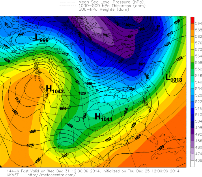
Looks like the 12zUKMET wants to eject the upper level low out of the Desert South West a bit faster than the GFS and ECMWF

12zUKMET 500mb forecast valid for Wednesday Morning.
Image


12zGFS Ensembles 500mb forecast valid for Wednesday Morning...All of the GFS Ensembles agree on a cut off upper level low in the Desert South West but the exact placement of the low is still a bit problematic.
Image
0 likes   
The following post is NOT an official forecast and should not be used as such. It is just the opinion of the poster and may or may not be backed by sound meteorological data. It is NOT endorsed by any professional institution including storm2k.org For Official Information please refer to the NHC and NWS products.

User avatar
TheProfessor
Professional-Met
Professional-Met
Posts: 3506
Age: 28
Joined: Tue Dec 03, 2013 10:56 am
Location: Wichita, Kansas

#1362 Postby TheProfessor » Thu Dec 25, 2014 2:31 pm

The GEFS is extremely wet too, It has 1.5-2 inches of what would be liquid precip for the Eastern half of Texas, including the DFW area, if that were to verify as all frozen precip it could very well rival last year's ice storm. :eek:
0 likes   
An alumnus of The Ohio State University.

Your local National Weather Service office is your best source for weather information.

CYCLONE MIKE
Category 5
Category 5
Posts: 2183
Joined: Tue Aug 31, 2004 6:04 pm
Location: Gonzales, LA

Re: Texas Winter 2014-2015

#1363 Postby CYCLONE MIKE » Thu Dec 25, 2014 3:08 pm

perk wrote:
Portastorm wrote:
CYCLONE MIKE wrote:So why are all the models now showing the cold air running into a brick wall and not making it any further south than north Texas then shooting east?


This is a common fault of the GFS and it does it every winter. See Ntxw's note above about why the model does this. Arctic or Polar air always, always, always comes down the leeside of the Rockies into the Southern Plains if the high cell comes into Montana. The only thing that would change that is a screaming Pacific jet stream which we don't have right now.


Portastorm nice try,but until CYCLONE MIKE has snow and ice covering his yard and home he's gonna continue to talk down the upcoming weather event. :D


Nah. I live in south LA and no matter what long range forecasters, analogs, and models say I don't think we will see anything close this winter to like what we have experienced in the past. Even with our ice episodes we had around here last year. Have to see it to believe, and not talking long range gfs maps :wink:
0 likes   

orangeblood
S2K Supporter
S2K Supporter
Posts: 3714
Joined: Tue Dec 15, 2009 6:14 pm
Location: Fort Worth, TX

Re: Texas Winter 2014-2015

#1364 Postby orangeblood » Thu Dec 25, 2014 4:04 pm

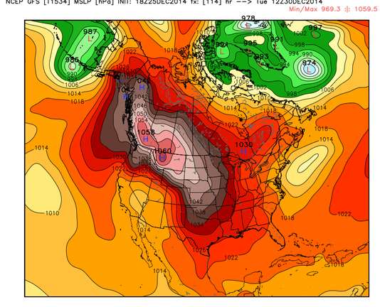
We're beginning to enter the NAM strike zone for evaluating the Arctic Air next week....it now has the Arctic HP building to an eye-popping 1059 in Alberta on Sunday evening with sub-zero temps crossing the border into North Dakota. Once that high begins in trek south, there won't be much to stop it particularly in the lower levels!

Image
0 likes   

User avatar
TeamPlayersBlue
Category 5
Category 5
Posts: 3445
Joined: Tue Feb 02, 2010 1:44 am
Location: Denver/Applewood, CO

#1365 Postby TeamPlayersBlue » Thu Dec 25, 2014 4:28 pm

Wow that is impressive. That big of a high-pressure will definitely bring extreme cold to be area. How does the snow cover look in the planes? The only comparison I can think of with a high that big is from 1983 or 89 but I don't know what the snow cover was like during those years. On the NWS Twitter page today they talk about the Christmas eve snowstorm for us in Southeast Texas. The upper level low was positioned south of Big Bend in northern Mexico for that event. As long as the upper level low digs in South enough to really get lots of Pacific moisture and feed it into the state I think many of us can be happy with what plays out.

For the Christmas eve event in 2000 for the forecast sounding showed lots of below freezing air throughout the entire column except at around 9000 feet were it was maybe 1°C this was out of Corpus Christi. I'm not sure if the air will be that cold in the upper levels of the atmosphere as with this event
0 likes   
Personal Forecast Disclaimer:
The posts in this forum are NOT official forecast and should not be used as such. They are just the opinion of the poster and may or may not be backed by sound meteorological data. They are NOT endorsed by any professional institution or storm2k.org. For official information, please refer to the NHC and NWS products.

User avatar
Ntxw
Storm2k Moderator
Storm2k Moderator
Posts: 22787
Joined: Wed Oct 21, 2009 6:34 pm
Location: DFW, Texas

#1366 Postby Ntxw » Thu Dec 25, 2014 4:43 pm

JMA too has 1058+. There's amazing agreement of an intense HP cell on all the guidance as they have trended stronger. I'm interested to see if they will show something beyond 1060+ at some point cause thats when you get to the elite tier of HP systems (1962, 1983, 1989 etc) as we get closer and better model resolution.

1983 had 1060mb high sitting in Montana on the 23rd if Im not mistaken.
0 likes   
The above post and any post by Ntxw is NOT an official forecast and should not be used as such. It is just the opinion of the poster and may or may not be backed by sound meteorological data. It is NOT endorsed by any professional institution including Storm2k. For official information, please refer to NWS products.

  Help support Storm2K!
Help Support Storm2K

User avatar
TexasF6
S2K Supporter
S2K Supporter
Posts: 816
Joined: Mon Aug 09, 2004 9:33 pm
Location: Austin, TX

Re: Texas Winter 2014-2015

#1367 Postby TexasF6 » Thu Dec 25, 2014 4:54 pm

Apologies on the url, shack is not working for me but...WOW :cold:

http://contours.hamweather.net/contours ... points.png
0 likes   

orangeblood
S2K Supporter
S2K Supporter
Posts: 3714
Joined: Tue Dec 15, 2009 6:14 pm
Location: Fort Worth, TX

Re:

#1368 Postby orangeblood » Thu Dec 25, 2014 4:59 pm

Ntxw wrote:JMA too has 1058+. There's amazing agreement of an intense HP cell on all the guidance as they have trended stronger. I'm interested to see if they will show something beyond 1060+ at some point cause thats when you get to the elite tier of HP systems (1962, 1983, 1989 etc) as we get closer and better model resolution.


Plus check out how asinine the models look dissipating the HP so quickly once it gets into the southern plains...the Euro takes it from 1050 in Kansas on Wednesday to 1028 in Texas in less than 24 hours. It's unfathomable an Arctic HP that strong would crater so quickly!! :double: Only explanation is it not being able to handle to southwest flow aloft.

Also, the Euro reloads at the end of week with even colder Arctic Air, this time straight out of the North Pole. With snowpack even greater across the plains, that one could have some records accompany it!! I couldn't draw a better synoptic pattern for winter weather across the southern plains the next couple of weeks.
Last edited by orangeblood on Thu Dec 25, 2014 5:01 pm, edited 1 time in total.
0 likes   

User avatar
SouthernMet
Category 3
Category 3
Posts: 857
Joined: Sun Aug 29, 2010 8:23 pm
Location: fort worth, tx

Re: Texas Winter 2014-2015

#1369 Postby SouthernMet » Thu Dec 25, 2014 4:59 pm

Another great discussion from Cavanaugh..
0 likes   
Nothing that SouthernMet posts, is an official forecast,nor does it reflect views of STORM2K.. SouthernMet is just adding to the great discussions on STORM2K.. Refer to NWS for official forecasts.

User avatar
TeamPlayersBlue
Category 5
Category 5
Posts: 3445
Joined: Tue Feb 02, 2010 1:44 am
Location: Denver/Applewood, CO

Re:

#1370 Postby TeamPlayersBlue » Thu Dec 25, 2014 5:06 pm

Ntxw wrote:JMA too has 1058+. There's amazing agreement of an intense HP cell on all the guidance as they have trended stronger. I'm interested to see if they will show something beyond 1060+ at some point cause thats when you get to the elite tier of HP systems (1962, 1983, 1989 etc) as we get closer and better model resolution.

1983 had 1060mb high sitting in Montana on the 23rd if Im not mistaken.

1064 I think.
0 likes   
Personal Forecast Disclaimer:
The posts in this forum are NOT official forecast and should not be used as such. They are just the opinion of the poster and may or may not be backed by sound meteorological data. They are NOT endorsed by any professional institution or storm2k.org. For official information, please refer to the NHC and NWS products.

Ntxwx
Tropical Storm
Tropical Storm
Posts: 153
Joined: Tue Jan 26, 2010 10:43 am
Location: Bridgeport, Texas

Re: Texas Winter 2014-2015

#1371 Postby Ntxwx » Thu Dec 25, 2014 5:14 pm

SouthernMet wrote:Another great discussion from Cavanaugh..


Except for the part when he says all the precip on 2nd might fall as rain.. :roll:
0 likes   

aggiecutter
Category 5
Category 5
Posts: 1753
Joined: Thu Oct 14, 2004 9:22 pm
Location: Texarkana

Re: Texas Winter 2014-2015

#1372 Postby aggiecutter » Thu Dec 25, 2014 5:37 pm

Since this is in the <5 day time frame, I am becoming a little bit optimistic that something significant might happen next week.

Image
0 likes   

User avatar
Ntxw
Storm2k Moderator
Storm2k Moderator
Posts: 22787
Joined: Wed Oct 21, 2009 6:34 pm
Location: DFW, Texas

Re: Texas Winter 2014-2015

#1373 Postby Ntxw » Thu Dec 25, 2014 5:40 pm

Ntxwx wrote:
SouthernMet wrote:Another great discussion from Cavanaugh..


Except for the part when he says all the precip on 2nd might fall as rain.. :roll:


It was a great discussion. I will refer to modification to orangeblood and srain's post. Another Alaskan ridge is in the offing as height fields remain high over the EPO on most if not all guidance. Euro actually shows snow breaking out as the trof kicks out over Nw, Nc, and Ne Texas. Has a few inches for DFW
0 likes   
The above post and any post by Ntxw is NOT an official forecast and should not be used as such. It is just the opinion of the poster and may or may not be backed by sound meteorological data. It is NOT endorsed by any professional institution including Storm2k. For official information, please refer to NWS products.


  Help support Storm2K!

Help Support Storm2K


User avatar
TexasF6
S2K Supporter
S2K Supporter
Posts: 816
Joined: Mon Aug 09, 2004 9:33 pm
Location: Austin, TX

Re: Texas Winter 2014-2015

#1374 Postby TexasF6 » Thu Dec 25, 2014 5:41 pm

aggiecutter wrote:Since this is in the <5 day time frame, I am becoming a little bit optimistic that something significant might happen next week.

Image


:double: :eek: :froze:
0 likes   

aggiecutter
Category 5
Category 5
Posts: 1753
Joined: Thu Oct 14, 2004 9:22 pm
Location: Texarkana

Re: Texas Winter 2014-2015

#1375 Postby aggiecutter » Thu Dec 25, 2014 5:43 pm

Shreveport AFD is buying into something significant late next week:

".THE MOISTURE BEGINS TO DEEPEN NEW YEAR/S DAY AND THEREAFTER
AHEAD OF SHORTWAVE ENERGY THAT WILL EJECT AHEAD OF A CLOSED LOW OVER
THE DESERT SW/NEAR THE CA COAST...WHICH MAY RESULT IN A CHANCE OF A
WINTRY MIX OVER THE NRN HALF OF THE REGION JUST BEYOND THE EXTENDED
RANGE."
0 likes   

User avatar
Portastorm
Storm2k Moderator
Storm2k Moderator
Posts: 9914
Age: 63
Joined: Fri Jul 11, 2003 9:16 am
Location: Round Rock, TX
Contact:

Re: Texas Winter 2014-2015

#1376 Postby Portastorm » Thu Dec 25, 2014 6:45 pm

SouthernMet wrote:Another great discussion from Cavanaugh..


Yes it was quite fascinating. I was particularly interested by his comments about surface temperatures and how the SW cutoff low is supposed to be disconnected by the polar westerlies and how that might impact P-types.

The guy is amazing.
0 likes   
Any forecasts under my name are to be taken with a grain of salt. Get your best forecasts from the National Weather Service and National Hurricane Center.

User avatar
TheProfessor
Professional-Met
Professional-Met
Posts: 3506
Age: 28
Joined: Tue Dec 03, 2013 10:56 am
Location: Wichita, Kansas

#1377 Postby TheProfessor » Thu Dec 25, 2014 6:50 pm

It looks like the 18z PGFS wants to challenge last years Ice storm, it shows about 3 inches of what looks to be sleet for most of the Metroplex and 6 inches around the I-35 corridor and west. :eek:
0 likes   
An alumnus of The Ohio State University.

Your local National Weather Service office is your best source for weather information.

User avatar
wxman57
Moderator-Pro Met
Moderator-Pro Met
Posts: 22980
Age: 67
Joined: Sat Jun 21, 2003 8:06 pm
Location: Houston, TX (southwest)

Re: Texas Winter 2014-2015

#1378 Postby wxman57 » Thu Dec 25, 2014 7:17 pm

Ntxw wrote:Wxman57 has posted this before but when you have a trof/storm in the southwest models tend to think it pumps ridging ahead of it and creates a block holding up the very cold air to the north of the boundary and warm to the south. But what they often mistake is low level cold bullies it's way south regardless in spite of with such strong HP and and dense air damming up against the Rockies. They will get colder, much colder a 1030+HP in the state of Texas usually results in subfreezing days for DFW in the past.

The EPO forecasts of late go anywhere from -3 to -5SD. Don't disregard that index, it rarely fails.


That is precisely what we have to watch for in this case. I think that the models are not depicting the shallow Arctic air well across Texas next week. I think that the sub-freezing air will penetrate farther south than the GFS and Euro are indicating. Thus the freezing/frozen precip risk may be farther south than today's model runs indicate.
0 likes   

User avatar
Rgv20
S2K Supporter
S2K Supporter
Posts: 2466
Age: 39
Joined: Wed Jan 05, 2011 5:42 pm
Location: Edinburg/McAllen Tx

#1379 Postby Rgv20 » Thu Dec 25, 2014 7:50 pm

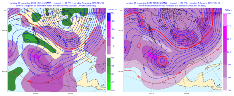
Just read the forecast discussion out of Dallas all I have to say is WOW.......Below is the 12zECMWF Ensemble Means 500mb forecast for New Years Day, Basically the Upper Level Low is giving the Euro and other model fits. The darker the Purple color the more uncertainty within the Ensembles

Image
0 likes   
The following post is NOT an official forecast and should not be used as such. It is just the opinion of the poster and may or may not be backed by sound meteorological data. It is NOT endorsed by any professional institution including storm2k.org For Official Information please refer to the NHC and NWS products.

User avatar
TeamPlayersBlue
Category 5
Category 5
Posts: 3445
Joined: Tue Feb 02, 2010 1:44 am
Location: Denver/Applewood, CO

#1380 Postby TeamPlayersBlue » Thu Dec 25, 2014 10:05 pm

Ahhhhh didn't know that with the darker purple, thanks!


Look at that storm the PGFS has. Geez that would be nuts.
Last edited by TeamPlayersBlue on Thu Dec 25, 2014 10:13 pm, edited 1 time in total.
0 likes   
Personal Forecast Disclaimer:
The posts in this forum are NOT official forecast and should not be used as such. They are just the opinion of the poster and may or may not be backed by sound meteorological data. They are NOT endorsed by any professional institution or storm2k.org. For official information, please refer to the NHC and NWS products.


Return to “Winter Weather”

Who is online

Users browsing this forum: No registered users and 4 guests