Texas Winter 2014-2015

Winter Weather Discussion

Moderator: S2k Moderators

Forum rules

The posts in this forum are NOT official forecast and should not be used as such. They are just the opinion of the poster and may or may not be backed by sound meteorological data. They are NOT endorsed by any professional institution or STORM2K.

Help Support Storm2K
Message
Author
User avatar
somethingfunny
ChatStaff
ChatStaff
Posts: 3926
Age: 37
Joined: Thu May 31, 2007 10:30 pm
Location: McKinney, Texas

Re: Texas Winter 2014-2015

#1541 Postby somethingfunny » Sat Dec 27, 2014 5:48 pm

The snow to our north and west this morning wasn't entirely unanticipated. The PGFS nailed it :)

As for that band over DFW, we have yet to see... I highly doubt it, but the model has performed well so far.

orangeblood (last night) wrote:
somethingfunny wrote:Sounds like a bunch of bunk to me about any snow with this weekend's system. Maybe some flurries mixing in out by Wichita Falls but nothing sticking, and nothing at all down here in the metro or anywhere southeast of Bowie I would say.


According to the latest GFS P, something more than a trace is moving through DFW on Sunday morning....

http://www.tropicaltidbits.com/analysis ... _wus_9.png
0 likes   
I am not a meteorologist, and any posts made by me are not official forecasts or to be interpreted as being intelligent. These posts are just my opinions and are probably silly opinions.

User avatar
vbhoutex
Storm2k Executive
Storm2k Executive
Posts: 29113
Age: 73
Joined: Wed Oct 09, 2002 11:31 pm
Location: Cypress, TX
Contact:

Re: Texas Winter 2014-2015

#1542 Postby vbhoutex » Sat Dec 27, 2014 6:13 pm

Portastorm wrote:Forecast and temp bust today at the PWC. Currently sitting at 42 and NWS said 46-47 by now. Five degree bust. Hmm ... wonder what happens next week. :wink:


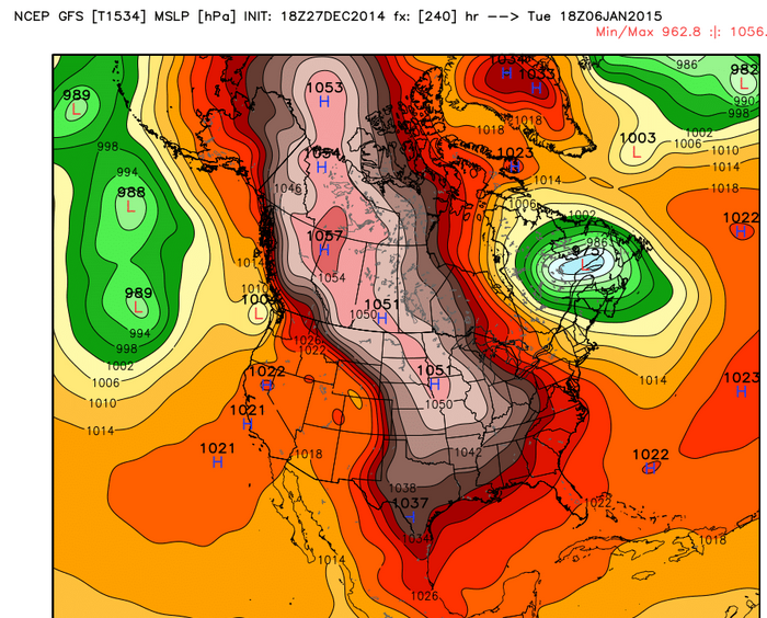
I've been tracking the source region....it's Siberian Air currently sitting north of Alaska/Near the Arctic Circle (some -25 to -30 F Deg Vodka Air) poised to rush southeast into NW Canada, straight down into the Plains. With plenty of snow cover all the way down into Colorado/Northern Kansas, I don't see a lot of modification and have a hard time believing the temp model output....BIG bust potential


Euro has a mammoth 1059mb high in Western Canada in about 48hrs and sinks to Montana at 1056mb in 72 yet its trying to hold up the cold air. I smell bust left and right with temperatures, the NAM looks better to me at the surface drilling the dense air mass. Im with wxman57 the front will be down to the Yucatan not stop at Brownsville.


Don't need to add much of anything to these. AS usual the models have lost and will pick up or have picked up on the actual strength of this cold air mass. Our local OCM are al model hugging fiercely and I just sit back and laugh. If there is anything I disagree with in any of the above it is the potential for modification. I think it is there, but this is such a dense air mass I'm not sure the usual modifiers will matter. Not about to call for Winter precip for SE TX this far out, but I won't be fainting if we do get some out of this. :froze: The 2nd Arctic plunge possibility really has my interest too. :cold: :cold:
0 likes   
Skywarn, C.E.R.T.
Please click below to donate to STORM2K to help with the expenses of keeping the site going:
Image

User avatar
Longhornmaniac8
Category 1
Category 1
Posts: 254
Joined: Thu Nov 18, 2010 2:30 am
Location: Austin, TX

Re: Texas Winter 2014-2015

#1543 Postby Longhornmaniac8 » Sat Dec 27, 2014 6:16 pm

vbhoutex wrote:
Portastorm wrote:Forecast and temp bust today at the PWC. Currently sitting at 42 and NWS said 46-47 by now. Five degree bust. Hmm ... wonder what happens next week. :wink:


I've been tracking the source region....it's Siberian Air currently sitting north of Alaska/Near the Arctic Circle (some -25 to -30 F Deg Vodka Air) poised to rush southeast into NW Canada, straight down into the Plains. With plenty of snow cover all the way down into Colorado/Northern Kansas, I don't see a lot of modification and have a hard time believing the temp model output....BIG bust potential


Euro has a mammoth 1059mb high in Western Canada in about 48hrs and sinks to Montana at 1056mb in 72 yet its trying to hold up the cold air. I smell bust left and right with temperatures, the NAM looks better to me at the surface drilling the dense air mass. Im with wxman57 the front will be down to the Yucatan not stop at Brownsville.


Don't need to add much of anything to these. AS usual the models have lost and will pick up or have picked up on the actual strength of this cold air mass. Our local OCM are al model hugging fiercely and I just sit back and laugh. If there is anything I disagree with in any of the above it is the potential for modification. I think it is there, but this is such a dense air mass I'm not sure the usual modifiers will matter. Not about to call for Winter precip for SE TX this far out, but I won't be fainting if we do get some out of this. :froze: The 2nd Arctic plunge possibility really has my interest too. :cold: :cold:


Where are you seeing this second Arctic plunge?
0 likes   

gpsnowman
S2K Supporter
S2K Supporter
Posts: 3186
Joined: Fri Jan 07, 2011 10:35 am
Location: Grand Prairie Tx

#1544 Postby gpsnowman » Sat Dec 27, 2014 6:34 pm

For those into weather folklore, the last ten days or so I have seen a big time bird migration south. Large V-flock formations wave after wave. Now, it is not uncommon to see birds fly south for the winter, and I don't think this natural migration is even folklore, but just observing this over the years tells me something is coming. Early November was the last time this was seen and we all know mid November was pretty darn cold. Last year was very noticeable before all the arctic outbreaks we had here in DFW. Maybe I am hallucinating from yearning for snowfall. Craving it. Like my Marlboros. Fingers crossed.
0 likes   

txprog
Tropical Low
Tropical Low
Posts: 30
Joined: Fri Aug 26, 2005 8:50 am

Re: Re:

#1545 Postby txprog » Sat Dec 27, 2014 6:35 pm

orangeblood wrote:
Ntxw wrote:Euro has a mammoth 1059mb high in Western Canada in about 48hrs and sinks to Montana at 1056mb in 72 yet its trying to hold up the cold air. I smell bust left and right with temperatures, the NAM looks better to me at the surface drilling the dense air mass. Im with wxman57 the front will be down to the Yucatan not stop at Brownsville.


I've been tracking the source region....it's Siberian Air currently sitting north of Alaska/Near the Arctic Circle (some -25 to -30 F Deg Vodka Air) poised to rush southeast into NW Canada, straight down into the Plains. With plenty of snow cover all the way down into Colorado/Northern Kansas, I don't see a lot of modification and have a hard time believing the temp model output....BIG bust potential

Image


It will be interesting to watch as this plays out. So-called Arctic air from very cold - nothing extreme but cold nonetheless - source regions on the way, headed down the plains, over a substantial snow pack, model predictions of very strong high pressure, and no forecast or model that I can find even has DFW below freezing for the upcoming period. I have commented on the historical nature of the number of days and weeks at DFW without a freeze, and if the forecast were to hold we will truly enter historical territory. But if, as many are saying, bustorama is certain, why are the local mets being so conservative with the predicted temps? Surely, the expert mets in FW, such as Cavanaugh, are not model huggers. This is not their first rodeo. We shall see.......
0 likes   

User avatar
Portastorm
Storm2k Moderator
Storm2k Moderator
Posts: 9914
Age: 63
Joined: Fri Jul 11, 2003 9:16 am
Location: Round Rock, TX
Contact:

Re: Texas Winter 2014-2015

#1546 Postby Portastorm » Sat Dec 27, 2014 6:50 pm

:uarrow:

Very good post there and you raise some credible questions. Cavanaugh is an excellent communicator to be sure. But if you go back to his discussions, you're going to see a lot of references to "guidance." What's "guidance?" That's the suite of computer models and automated grid numbers they look at. These days, NWS forecasters appear to be trained in that way ... not looking too much beyond the models unless they have a lot of local experience. To be honest, I've never examined how well Cavanaugh's forecasts verify or not. If he's as good a forecaster as his AFDs, then he's something special. My point here is that even he is reluctant to throw out any model solution and go with a hunch.

At this point, I don't see why they should deviate much from guidance. The storm which is supposed to cut off is over the far reaches of northwestern North America and barely in range for upper air sampling. By Monday, the models should have a decent grasp of the cutoff low as well as upstream temps and if we're still seeing forecasts of all liquid precip ... it might be time to put away our party favors. Most of the Texas-based NWSFOs are at least mentioning the possibility of wintry precip. They can ramp up their forecasts as needed 24-36 hours out.
0 likes   
Any forecasts under my name are to be taken with a grain of salt. Get your best forecasts from the National Weather Service and National Hurricane Center.

gpsnowman
S2K Supporter
S2K Supporter
Posts: 3186
Joined: Fri Jan 07, 2011 10:35 am
Location: Grand Prairie Tx

#1547 Postby gpsnowman » Sat Dec 27, 2014 6:53 pm

:uarrow:
Good post txprog. I recently re-read the Christmas Eve 2009 snow posts on Storm2k. A member(can't remember who) posted an excerpt from a NWS Fort Worth discussion just a couple days from the event that read their would be no white Christmas. We all know how that worked out. Blizzard conditions. Playing conservative up until the actual event is the safe way to go. The model mayhem is also an obvious reason why. But it seems to me every winter this happens at least once, an unexpected durable cold spell with unanticipated moisture. Like today for example in Wichita Falls and southwestern Oklahoma. Ok, I am rambling. Hope this pans out for some snow, and I trust the smarter folks on here to give us the latest, conservative or not.
Forecasting winter weather in Texas is not an easy task. Kudos to all of those who keep us updated and informed. It may seem slow and chaotic, but that is why the experts know way more about weather than I do. Thanks.
0 likes   

User avatar
somethingfunny
ChatStaff
ChatStaff
Posts: 3926
Age: 37
Joined: Thu May 31, 2007 10:30 pm
Location: McKinney, Texas

Re: Texas Winter 2014-2015

#1548 Postby somethingfunny » Sat Dec 27, 2014 7:35 pm

Cavanaugh did mention in a recent AFD that while he does not believe any of these warm models, he cannot justify forecasting anything colder than the coldest model at his disposal is showing - but also stated that actual temperatures could very well go even colder than that by quite a bit.

Regarding this heavy rain potential, it might actually bust our freezing precip potential, as heavy precip brings down air from higher in the atmospheric column.... this is normally how we "wet bulb" with heavy precip changing from rain into snow as cold air is brought down to the surface by the precipitation, but in this situation we would actually have warmer air above the freezing layer at the surface, wouldn't we? It depends on how deep the cold air is, but this might start as rain, freeze quickly, put down an ice layer, but then revert to plain rain and melt the ice.

That said, FWD posted this:

THE ENERGY OUT
WEST IS STARTING TO SHOW SIGNS OF CLOSING OFF OVER ARIZONA BY
WEDNESDAY...BUT A LEAD SHORTWAVE WILL LIFT NORTHEAST OVER THE AREA
AND INDUCE ISENTROPIC ASCENT OVER THE SHALLOW ARCTIC AIR BY
WEDNESDAY NIGHT INTO THURSDAY WITH MODELS DIFFERING SOMEWHAT ON
ENVIRONMENTAL PROFILES...PRECIP TYPES...AND OVERALL TEMPERATURES.
SO CONFIDENCE ON THE OVERALL EVOLUTION OF ANY WINTER WEATHER
LATER IN THE WEEK REMAINS LOW...BUT APPEARS SOME CHANCE OF A MIX
WILL BE THERE WITH CHILLY CONDITIONS CONTINUING.

That shortwave on New Years Eve/Day is very concerning. This could be a very dangerous situation with sleep-deprived, drunk partygoers driving home on icy roads after midnight. :double:

I'll likely be delivering pizzas up until midnight too. :roll:
0 likes   
I am not a meteorologist, and any posts made by me are not official forecasts or to be interpreted as being intelligent. These posts are just my opinions and are probably silly opinions.

User avatar
Ntxw
Storm2k Moderator
Storm2k Moderator
Posts: 22788
Joined: Wed Oct 21, 2009 6:34 pm
Location: DFW, Texas

#1549 Postby Ntxw » Sat Dec 27, 2014 7:59 pm

Cold is not the problem. The EPO is working it's magic, the ridge in the Pacific is already building into Alaska. Never question the -EPO the cold will be there, it is tanking. Every guidance has it tanking it will get very cold. I've learned to well to doubt that index as a cold loading feature. The question remains how the system in the west behaves. Backwards S spells trouble in the past.

Image

Image

It is all about timing, if impulses come out then you have trouble. There is another arctic attack behind it, it is rarely seen an ENS suite converge on strong height fields at the range given and the OP have gradually followed by holding the ridge into the Alaskan Peninsula.
0 likes   
The above post and any post by Ntxw is NOT an official forecast and should not be used as such. It is just the opinion of the poster and may or may not be backed by sound meteorological data. It is NOT endorsed by any professional institution including Storm2k. For official information, please refer to NWS products.

  Help support Storm2K!
Help Support Storm2K

aggiecutter
Category 5
Category 5
Posts: 1753
Joined: Thu Oct 14, 2004 9:22 pm
Location: Texarkana

Re:

#1550 Postby aggiecutter » Sat Dec 27, 2014 8:10 pm

Ntxw wrote:It is all about timing, if impulses come out then you have trouble. There is another arctic attack behind it, it is rarely seen an ENS suite converge on strong height fields at the range given and the OP have gradually follow by holding the ridge into the Alaskan Peninsula.


For the event the end of next week, I still think freezing rain is the most likely scenario. I think the shallow dense cold air will get trapped as the moisture returns on Thursday. As you mentioned, the arctic attack that follows the one next week looks quite impressive:


Image
Last edited by aggiecutter on Sun Dec 28, 2014 3:15 am, edited 2 times in total.
0 likes   

User avatar
Kludge
S2K Supporter
S2K Supporter
Posts: 215
Joined: Thu Aug 26, 2004 9:03 pm
Location: Montgomery, Texas

Re: Re:

#1551 Postby Kludge » Sat Dec 27, 2014 9:51 pm

aggiecutter wrote:
Ntxw wrote:It is all about timing, if impulses come out then you have trouble. There is another arctic attack behind it, it is rarely seen an ENS suite converge on strong height fields at the range given and the OP have gradually follow by holding the ridge into the Alaskan Peninsula.


For the event the end of next week, I still think freezing rain is the most likely scenario. I think the shallow dense cold air will get trapped as the moisture returns on Thursday. As you mentioned. the arctic attack that follows the one next week, looks quite impressive:


Agreed.

I'm afraid that we're looking at an event comprised of moderate rainfall (1/4 - 3/4") through a shallow ( <5000' ) layer of sub-freezing temperatures.

My thinking is the target area will be between I-20 and I-10, and generally east of I-35.

I would dearly love to be totally wrong on this. Consider this to be a "dreadcast", not a wishcast. I'm going on many years of "gut feel" here.

[ I am NOT a met. See the NWS for official forecasts. ]
0 likes   

DougNTexas
Tropical Depression
Tropical Depression
Posts: 54
Age: 73
Joined: Thu Dec 17, 2009 4:45 pm
Location: Price, Texas

Re: Texas Winter 2014-2015

#1552 Postby DougNTexas » Sat Dec 27, 2014 10:23 pm

My local weatherbug does not show Henderson, Tx getting below 32 degrees in the next 10 days as of today.
0 likes   

ronyan
S2K Supporter
S2K Supporter
Posts: 791
Age: 39
Joined: Tue Sep 09, 2008 5:46 pm
Location: Lake Jackson, TX

Re: Texas Winter 2014-2015

#1553 Postby ronyan » Sat Dec 27, 2014 11:01 pm

DougNTexas wrote:My local weatherbug does not show Henderson, Tx getting below 32 degrees in the next 10 days as of today.

It's likely to be colder given the current pattern, negative EPO and the time of year. The GFS already has temps near 32 in your area with the first Arctic front on the 1st. Seeing as how we think it's warm biased, I wouldn't take that forecast to the bank.
0 likes   

User avatar
SouthernMet
Category 3
Category 3
Posts: 857
Joined: Sun Aug 29, 2010 8:23 pm
Location: fort worth, tx

Re: Texas Winter 2014-2015

#1554 Postby SouthernMet » Sat Dec 27, 2014 11:36 pm

00z PGFS still very bullish on qpf, but the precip moves through a little earlier than recent trends, still shows warming after the onset of precip.
0 likes   
Nothing that SouthernMet posts, is an official forecast,nor does it reflect views of STORM2K.. SouthernMet is just adding to the great discussions on STORM2K.. Refer to NWS for official forecasts.

Ralph's Weather
S2K Supporter
S2K Supporter
Posts: 3269
Age: 38
Joined: Fri Dec 13, 2013 11:55 am
Location: Lindale, TX
Contact:

#1555 Postby Ralph's Weather » Sun Dec 28, 2014 12:33 am

It is really starting to look like a potential ice storm for New Year's. I think we are all in agreement that there will not be as much warning ahead of the trough as is shown by the models. Maybe we can get lucky and the cold is deeper than expected. The models do not have a handle on next week's system so I will go with something similar too this coming week until the models come into some kind of agreement.
0 likes   
Follow on Facebook at Ralph's Weather.

orangeblood
S2K Supporter
S2K Supporter
Posts: 3714
Joined: Tue Dec 15, 2009 6:14 pm
Location: Fort Worth, TX

Re: Texas Winter 2014-2015

#1556 Postby orangeblood » Sun Dec 28, 2014 12:38 am

SouthernMet wrote:00z PGFS still very bullish on qpf, but the precip moves through a little earlier than recent trends, still shows warming after the onset of precip.


Check out the latest Canadian run...looking much more realistic.
Last edited by orangeblood on Sun Dec 28, 2014 12:47 am, edited 2 times in total.
0 likes   

User avatar
SouthernMet
Category 3
Category 3
Posts: 857
Joined: Sun Aug 29, 2010 8:23 pm
Location: fort worth, tx

Re: Texas Winter 2014-2015

#1557 Postby SouthernMet » Sun Dec 28, 2014 12:43 am

orangeblood wrote:
SouthernMet wrote:00z PGFS still very bullish on qpf, but the precip moves through a little earlier than recent trends, still shows warming after the onset of precip.


Check out the latest Canadian run...looking much more realistic


Wow... That looks very plausible imo.

Precip starts new years eve night too, which is a bit earlier.
Last edited by SouthernMet on Sun Dec 28, 2014 12:46 am, edited 1 time in total.
0 likes   
Nothing that SouthernMet posts, is an official forecast,nor does it reflect views of STORM2K.. SouthernMet is just adding to the great discussions on STORM2K.. Refer to NWS for official forecasts.

User avatar
Portastorm
Storm2k Moderator
Storm2k Moderator
Posts: 9914
Age: 63
Joined: Fri Jul 11, 2003 9:16 am
Location: Round Rock, TX
Contact:

Re: Texas Winter 2014-2015

#1558 Postby Portastorm » Sun Dec 28, 2014 12:45 am

:uarrow:

I could be wrong orangeblood but I believe that 0z CMC run is the coldest looking run yet from a global model for next week. Will be interesting to see if the others follow suit. The 0z GFS and PGFS were much different from 12z runs.
0 likes   
Any forecasts under my name are to be taken with a grain of salt. Get your best forecasts from the National Weather Service and National Hurricane Center.

User avatar
TheProfessor
Professional-Met
Professional-Met
Posts: 3506
Age: 28
Joined: Tue Dec 03, 2013 10:56 am
Location: Wichita, Kansas

#1559 Postby TheProfessor » Sun Dec 28, 2014 12:50 am

:uarrow: And if the CMC continues to trend colder with that amount of precip then North and Central Texas could all be in trouble, and the worst part is it could all come in time for the Cowboys game next week. :eek:
0 likes   
An alumnus of The Ohio State University.

Your local National Weather Service office is your best source for weather information.

orangeblood
S2K Supporter
S2K Supporter
Posts: 3714
Joined: Tue Dec 15, 2009 6:14 pm
Location: Fort Worth, TX

Re: Texas Winter 2014-2015

#1560 Postby orangeblood » Sun Dec 28, 2014 12:55 am

Portastorm wrote::uarrow:

I could be wrong orangeblood but I believe that 0z CMC run is the coldest looking run yet from a global model for next week. Will be interesting to see if the others follow suit. The 0z GFS and PGFS were much different from 12z runs.


Yep, it's much colder and similar to what the PGFS was showing a few days ago. Showing the two separate events that we've been discussing around here over the past week, one impulse that comes out along the Arctic Boundary on New Years Eve and the other 24-36 hours later. Over an inch QPF from 35 eastward
0 likes   


Return to “Winter Weather”

Who is online

Users browsing this forum: No registered users and 2 guests