Texas Winter 2014-2015
Moderator: S2k Moderators
Forum rules
 The posts in this forum are NOT official forecast and should not be used as such. They are just the opinion of the poster and may or may not be backed by sound meteorological data. They are NOT endorsed by any professional institution or STORM2K.

The posts in this forum are NOT official forecast and should not be used as such. They are just the opinion of the poster and may or may not be backed by sound meteorological data. They are NOT endorsed by any professional institution or STORM2K.
-
CentralTxAggie

- Tropical Depression

- Posts: 63
- Joined: Fri Feb 07, 2014 11:03 am
- Location: TX
-
Ralph's Weather
- S2K Supporter

- Posts: 3371
- Age: 38
- Joined: Fri Dec 13, 2013 11:55 am
- Location: Lindale, TX
- Contact:
Re: Re:
TheProfessor wrote:This was Said earlier but we are pretty confident on the cold as long as the models aren't overdoing the high pressure, But if we see 1050mb + High in Montana then it's going to get cold.
I agree with this either the models are severely overdoing the high or they are severely underdoing the cold. A 1050mb+ high will send the very cold air building in Canada quickly down the Plains. Even if the high comes in weaker than forecasted it will likely get colder than modeled.
Last edited by Ralph's Weather on Sun Dec 28, 2014 11:13 pm, edited 1 time in total.
0 likes
Follow on Facebook at Ralph's Weather.
-
weatherguy425
- Tropical Storm

- Posts: 180
- Joined: Sun Aug 16, 2009 1:06 pm
- Location: Houston, TX > Lubbock, TX > Savannah, GA
- Contact:
Re: Texas Winter 2014-2015
So, what is actually going on 'up there'? 00z surface analysis is up to 1056. Not too shabby, even at this point...

0 likes
-
Texas Snowman

- Storm2k Moderator

- Posts: 6197
- Joined: Fri Jan 25, 2008 11:29 am
- Location: Denison, Texas
@RyanMaue: Late Monday, 1060-mb high pressure sets up shop over Montana w/Arctic air plunging south & west.
0 likes
The above post and any post by Texas Snowman is NOT an official forecast and should not be used as such. It is just the opinion of the poster and may or may not be backed by sound meteorological data. It is NOT endorsed by any professional institution including storm2k.org. For official information, please refer to NWS products.
-
Ralph's Weather
- S2K Supporter
- Posts: 3371
- Age: 38
- Joined: Fri Dec 13, 2013 11:55 am
- Location: Lindale, TX
- Contact:
FWD mentions possible icing tonight from fog in their eastern areas tonight. This concern extents into my area as I am just east of their counties and we reached freezing earlier this evening. Guess we get a practice run for later in the week.
0 likes
Follow on Facebook at Ralph's Weather.
-
TheProfessor

- Professional-Met

- Posts: 3506
- Age: 29
- Joined: Tue Dec 03, 2013 10:56 am
- Location: Wichita, Kansas
I'm going to be going to NWS FWD tomorrow, it will be the third one I've been to, I've been to the one near Jackson Mississippi and the one in Norman, but I'm pretty excited to see the one in Fort Worth.
0 likes
An alumnus of The Ohio State University.
Your local National Weather Service office is your best source for weather information.
Your local National Weather Service office is your best source for weather information.
-
SouthernMet

- Category 3

- Posts: 857
- Joined: Sun Aug 29, 2010 8:23 pm
- Location: fort worth, tx
Re: Texas Winter 2014-2015
CMC @ 90 hours : http://www.tropicaltidbits.com/analysis ... s=210.9091
tho ZR is hard to accumulate during the day & with marginal temps, still something to watch in case the onset comes faster than what's shown here. Going to have to watch where the sleet/freezing rain line shows up because the freezing rain could potentially warm sfc temps while sleet could bring in CAA...
tho ZR is hard to accumulate during the day & with marginal temps, still something to watch in case the onset comes faster than what's shown here. Going to have to watch where the sleet/freezing rain line shows up because the freezing rain could potentially warm sfc temps while sleet could bring in CAA...
0 likes
Nothing that SouthernMet posts, is an official forecast,nor does it reflect views of STORM2K.. SouthernMet is just adding to the great discussions on STORM2K.. Refer to NWS for official forecasts.
-
SouthernMet
- Category 3
- Posts: 857
- Joined: Sun Aug 29, 2010 8:23 pm
- Location: fort worth, tx
Re: Texas Winter 2014-2015
latest sref again, not as cold, but shows copious amounts of qpf to work with, starting thursday morning.
06z nam looks similar with scattered light frozen precip breaking out in 39 hours & continuing through the end of its run..
06z nam looks similar with scattered light frozen precip breaking out in 39 hours & continuing through the end of its run..
0 likes
Nothing that SouthernMet posts, is an official forecast,nor does it reflect views of STORM2K.. SouthernMet is just adding to the great discussions on STORM2K.. Refer to NWS for official forecasts.
-
BrokenGlassRepublicn
- Category 1

- Posts: 483
- Joined: Sun Nov 20, 2011 8:07 pm
- Location: Richardson, Texas
Re: Texas Winter 2014-2015
srainhoutx wrote:The 12Z operational guidance is trending to a more progressive solution with the Western cold upper trough/closed cold core low. This would fit the pattern we've been experiencing all Fall and early Winter, so expect further refinement as the guidance attempts to resolve the upper air pattern expected next week.
Can you explain the meaning of "more progressive"?
0 likes

Re:
CentralTxAggie wrote:Thanks for the Welcomes!!!
Hey I'm in South Austin as well, closer to South Austin Hospital. Welcome! It's always nice to see more Austin posters on here.
0 likes
Resident Rain Miser
I am a weather hobbyist living 3.5 miles south of Downtown Austin and in no way or fashion should anything I say concerning forecasts be taken seriously. Please check your local NWS for accurate weather forecasting and conditions.
I am a weather hobbyist living 3.5 miles south of Downtown Austin and in no way or fashion should anything I say concerning forecasts be taken seriously. Please check your local NWS for accurate weather forecasting and conditions.
-
SouthernMet
- Category 3
- Posts: 857
- Joined: Sun Aug 29, 2010 8:23 pm
- Location: fort worth, tx
Re: Texas Winter 2014-2015
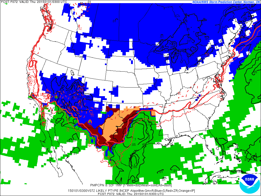
Imo this is still looking like a perfect setup for freezing drizzle late Tuesday night, into Wednesday. With any impacts depending on if sfc temps are in mid 20's or lower 30's..
Wednesday night into thursday morning - it looks like lift increases enough for bands of *what could be* sleet to move into north tx from the southwest. This is crucial because models are showing marginal temps for this time frame(28-33), with Warm Air Advection moving back into the metroplex..
Freezing rain - to sleet - to then rain, is possible if warm air advection takes place and models are accurate regarding temps Thursday morning - Friday. On the other hand.. If we get a solid snow pack to our north & decent sleet accumulations here (not likely) then cold air advection could actually take place first, keeping our predominate form of precip, frozen. This is an outlying scenario, but one I see as possible.
This is my 2 cents, subject to change.
0 likes
Nothing that SouthernMet posts, is an official forecast,nor does it reflect views of STORM2K.. SouthernMet is just adding to the great discussions on STORM2K.. Refer to NWS for official forecasts.

Re: Texas Winter 2014-2015
The Hounds of Winter are UNLEASHED!!!! It is -26 below zero in Minnesota. The air is on the move. Perhaps we do get two shots of Arctic air after all. I still feel it may become irresponsible for local mets on TV to keep saying nothing will happen (certainty) as I just witnessed on local cbs affiliate. The WPC has Austin progged with 5% chance for FD on NYE, and magnifies those chances the following days!!!! We must be vigilant!!!
http://wx.hamweather.com/maps/currents/ ... p/nam.html
_____________________________________________________________________________________________________________________________________________This is not an official forecast. Refer to the NWS for official weather updates. I do love meteorology though.
0 likes
Re: Texas Winter 2014-2015
SPECIAL WEATHER STATEMENT
NATIONAL WEATHER SERVICE FORT WORTH TX
417 AM CST MON DEC 29 2014
TXZ091>095-100>107-115>123-129>135-141>148-156>162-174-175-292100-
MONTAGUE-COOKE-GRAYSON-FANNIN-LAMAR-YOUNG-JACK-WISE-DENTON-COLLIN-
HUNT-DELTA-HOPKINS-STEPHENS-PALO PINTO-PARKER-TARRANT-DALLAS-
ROCKWALL-KAUFMAN-VAN ZANDT-RAINS-EASTLAND-ERATH-HOOD-SOMERVELL-
JOHNSON-ELLIS-HENDERSON-COMANCHE-MILLS-HAMILTON-BOSQUE-HILL-
NAVARRO-FREESTONE-ANDERSON-LAMPASAS-CORYELL-BELL-MCLENNAN-FALLS-
LIMESTONE-LEON-MILAM-ROBERTSON-
417 AM CST MON DEC 29 2014
...A MIX OF WINTER PRECIPITATION POSSIBLE FOR NORTH TEXAS TUESDAY
NIGHT THROUGH THURSDAY MORNING...
AN ARCTIC COLD FRONT WILL MOVE ACROSS NORTH TEXAS TONIGHT THROUGH
TUESDAY. INITIALLY THE FRONT WILL COME THROUGH DRY.
HOWEVER...MOISTURE AND LIFT WILL INCREASE OVER THE COLD SURFACE
AIR TUESDAY NIGHT THROUGH THURSDAY.
THERE IS A CHANCE OF A MIX OF LIGHT RAIN...LIGHT FREEZING RAIN
AND/OR LIGHT SLEET ACROSS THE EXTREME WESTERN COUNTIES TUESDAY
NIGHT AND SPREADING EAST TO INCLUDE THE WESTERN HALF OF NORTH
TEXAS WEDNESDAY THROUGH THURSDAY MORNING. THIS GENERALLY INCLUDES
AN AREA ALONG AND WEST OF A LINE FROM SHERMAN TO FORT WORTH TO
WACO TO LAMPASAS. IT APPEARS THAT ANY PRECIPITATION THAT FALLS
ACROSS NORTH TEXAS DURING THIS TIME PERIOD WILL BE LIGHT WITH
MINIMAL ACCUMULATIONS. HOWEVER...EVEN A LIGHT GLAZE CAN RESULT IN
HAZARDOUS DRIVING CONDITIONS. PRECIPITATION SHOULD TURN TO ALL
RAIN BY THURSDAY AFTERNOON.
NORTH TEXAS RESIDENTS SHOULD KEEP A CLOSE EYE ON THE WEATHER
FORECASTS OVER THE NEXT SEVERAL DAYS SINCE THE POTENTIAL FOR SOME
WINTER WEATHER PRECIPITATION AND IMPACTS TO TRAVEL ARE POSSIBLE
DURING THE NEW YEARS HOLIDAY.
0 likes
-
srainhoutx

- S2K Supporter
- Posts: 6919
- Age: 68
- Joined: Sun Jan 14, 2007 11:34 am
- Location: Haywood County, NC
- Contact:
Re: Texas Winter 2014-2015
After a nasty cold rainy Sunday where temperatures remained stuck near 39F to the low 40’s which busted big time from the highs near 50F expected, today will be a transitional day as the Arctic front currently located near the Nebraska/Kansas border begins to drop S. Fog has developed across area E of a Brenham/Sealy line and may take some time to scour out before partly cloudy skies arrive this afternoon…if then.
The much talked about Arctic front arrives tomorrow with its near 1060mb High pressure cell over Montana/Wyoming and the very cold upper trough out West continues to drop toward Southern California before closing off and forming a cold core upper Low near Las Vegas Tuesday morning. Very chilly temperatures across the West are expected and snow is likely in Las Vegas, just N of Phoenix into Tucson and very far S in Western New Mexico as the Arctic front spills E over the Eastern Mountain gaps of the New Mexico into the Rio Grande River High Plains. The Arctic high will settled into Western Kansas and modify to around 1045mb which gives us an idea of just how dense this Arctic air mass is. The front will clear the Texas Coast Tuesday afternoon/ evening with increasing cold air advection Tuesday night into New Year’s Eve.
The challenging part of the forecast for much of Texas begins in earnest New Year’s Eve afternoon as up glide and over running moisture from the Eastern Pacific begins to saturate the upper/mid levels. The worrisome forecasting challenge is what the short term meso guidance indicates Wednesday afternoon. Light precipitation breaks out along the Rio Grande as the closed upper low begins to slowly move E over Arizona. The GFS and ECMWF are a bit drier with the surface boundary versus the aggressive NAM/WRF/SREF meso guidance that suggest a couple of 100th of an inch of light drizzle or light rain breaks out across S Central Texas spreading ENE New Year’s Eve night. Those shorter range models also suggest that surface temperatures are just below freezing along and N of the I-35 Corridor from just N of San Antonio and Austin and just W of the Dallas/Ft Worth area. The 2 meter temperature profiles for SE Texas as near 34 to 36 degrees along and N of I-10. These temperature profiles at the surface may…big emphasis on may…might be too warm 72 plus hours out via the computer guidance. The NAM and SREF are suggesting an upper air disturbance arrives ahead of the main closed core upper low generating just enough lift to saturate the surface boundary during our New Year’s Eve festivities as we ring in the New Year. This continues into New Year’s Day. The next fly in the ointment is a Coastal wave developing Thursday night and just how close to the Coast a warm front actually makes it. The current thinking is the Coastal wave and warm from may remain just offshore, but warming temperatures are depicted by the guidance as the Arctic high weakens and retreats E. It is noteworthy that the computer models often are too quick to erode the cold air at the surface once it becomes entrenched, so we will need to monitor the trends the next couple of days. The most worrisome period in New Year’s Eve and early New Year’s Day at the moment. With so many forecasting challenges to a busy Holiday period, it is prudent to keep tabs on the weather closely later today and tomorrow into Wednesday before venturing out for a night of New Year’s Eve activities.
0 likes
Carla/Alicia/Jerry(In The Eye)/Michelle/Charley/Ivan/Dennis/Katrina/Rita/Wilma/Ike/Harvey
Member: National Weather Association
Wx Infinity Forums
http://wxinfinity.com/index.php
Facebook.com/WeatherInfinity
Twitter @WeatherInfinity
Member: National Weather Association
Wx Infinity Forums
http://wxinfinity.com/index.php
Facebook.com/WeatherInfinity
Twitter @WeatherInfinity
Re: Texas Winter 2014-2015
Nice one gpsnowman!!!
gpsnowman wrote:TexasF6 wrote:The Hounds of Winter are UNLEASHED!!!! It is -26 below zero in Minnesota. The air is on the move. Perhaps we do get two shots of Arctic air after all. I still feel it may become irresponsible for local mets on TV to keep saying nothing will happen (certainty) as I just witnessed on local cbs affiliate. The WPC has Austin progged with 5% chance for FD on NYE, and magnifies those chances the following days!!!! We must be vigilant!!!
http://wx.hamweather.com/maps/currents/ ... p/nam.html
Wow, Canada is frigid! Wouldn't be nice to have the North Pole park itseld over the central US with wave after wave of snow. I need to stop daydreaming.
_____________________________________________________________________________________________________________________________________________This is not an official forecast. Refer to the NWS for official weather updates. I do love meteorology though.
0 likes
-
Ralph's Weather
- S2K Supporter
- Posts: 3371
- Age: 38
- Joined: Fri Dec 13, 2013 11:55 am
- Location: Lindale, TX
- Contact:
Made it down to 29 here before rising to 37 by sunrise. We are in for a very interesting week beginning with huge temperature falls tonight into tomorrow.
0 likes
Follow on Facebook at Ralph's Weather.

Re: Texas Winter 2014-2015
From Shreveport NWS...
DISCUSSION...
OTHER THAN SOME FOG AND PATCHY DRIZZLE THIS MORNING...WILL GO WITH
A DRY FORECAST THOUGH MIDWEEK. A MASSIVE ARCTIC HIGH OVER SOUTHWEST
CANADA THIS MORNING WILL MOVE SOUTHEAST INTO OKLAHOMA BY WEDNESDAY...
KEEPING THE REGION UNDER A COLD AND DRY AIRMASS...WITH MUCH BELOW
NORMAL TEMPS. THE NEXT SYSTEM TO BRING A WEATHER CHANGE WILL BE
A LONGWAVE TROUGH...WHICH WILL DIG ACROSS THE GREAT BASIN TUESDAY...
CLOSING OFF OVER SOUTHERN CA BY LATE WEDNESDAY. MODELS ARE IN
FAIRLY GOOD AGREEMENT WITH TIMING AND PLACEMENT OF THIS SYSTEM
THROUGH A LEAST THURSDAY. AHEAD OF THIS SYSTEM...EXPECT THE ONSET
ON LIGHT PRECIPITATION ACROSS SOUTHWESTERN ZONES THURSDAY
MORNING...FOLLOWED BY MORE WIDESPREAD AND MODERATE RAIN LATER IN
THE DAY CONTINUING INTO THE WEEKEND. MODELS NOW HAVE THE CLOSED
LOW REMAINING WEST OF THE CWA THROUGH SATURDAY...SO HOLDING RAIN
IN A LITTLE LONGER. WITH THE COLD...DRY AIR IN PLACE AHEAD OF THE
CLOUDS AND RAIN THURSDAY MORNING...SOME LIGHT FREEZING RAIN AND
SLEET IS POSSIBLE. HOWEVER...CONFIDENCE REMAINS LOW THAT THE RAIN
WILL BEGIN BEFORE TEMPS CLIMB ABOVE FREEZING...SO WILL NOT MENTION
IN FCST ATTM.
AFTER THIS SYSTEM MOVES EAST OF THE AREA ON SUNDAY...DRIER AIR AND
SUNSHINE SHOULD RETURN...BUT TEMPS WILL REMAIN BELOW NORMAL AS
ANOTHER ARCTIC HIGH MOVES SOUTH FROM CANADA. /14/
0 likes
-
TeamPlayersBlue

- Category 5

- Posts: 3523
- Joined: Tue Feb 02, 2010 1:44 am
- Location: Denver/Applewood, CO
http://mp1.met.psu.edu/~fxg1/NARR/1983/us1224.php
First i would like to say that comparing this event to the 1983 event could be dangerous territory and i am not expecting this event to be this great, but i would like for some of the pro mets to explain to me how this event will be different as far as the cold is concerned. I understand we will have an ULL in the southwest, which could effect the cold air slightly but check out the map in the link. Right now, models are showing the air progressing east and not funneling all the way down into Central Tx, but look at the 500 and 700 MB maps back in '83. Other than the ULL being in the southwest, it is very similar, hence why the analogs point to 1983.
I know the models cant handle shallow air very well and an event like this one with an HP this big is where but can the potential for a bust be really this big?
0 likes
Personal Forecast Disclaimer:
The posts in this forum are NOT official forecast and should not be used as such. They are just the opinion of the poster and may or may not be backed by sound meteorological data. They are NOT endorsed by any professional institution or storm2k.org. For official information, please refer to the NHC and NWS products.
The posts in this forum are NOT official forecast and should not be used as such. They are just the opinion of the poster and may or may not be backed by sound meteorological data. They are NOT endorsed by any professional institution or storm2k.org. For official information, please refer to the NHC and NWS products.
-
Ralph's Weather
- S2K Supporter
- Posts: 3371
- Age: 38
- Joined: Fri Dec 13, 2013 11:55 am
- Location: Lindale, TX
- Contact:
Re:
I am with you on this. I guess the models think that the SW flow aloft will have a huge impact on the temps. I am doubting that especially for Wednesday.TeamPlayersBlue wrote:http://mp1.met.psu.edu/~fxg1/NARR/1983/us1224.php
First i would like to say that comparing this event to the 1983 event could be dangerous territory and i am not expecting this event to be this great, but i would like for some of the pro mets to explain to me how this event will be different as far as the cold is concerned. I understand we will have an ULL in the southwest, which could effect the cold air slightly but check out the map in the link. Right now, models are showing the air progressing east and not funneling all the way down into Central Tx, but look at the 500 and 700 MB maps back in '83. Other than the ULL being in the southwest, it is very similar, hence why the analogs point to 1983.
I know the models cant handle shallow air very well and an event like this one with an HP this big is where but can the potential for a bust be really this big?
0 likes
Follow on Facebook at Ralph's Weather.
Who is online
Users browsing this forum: Brent and 103 guests