Texas Winter 2014-2015

Winter Weather Discussion

Moderator: S2k Moderators

Forum rules

The posts in this forum are NOT official forecast and should not be used as such. They are just the opinion of the poster and may or may not be backed by sound meteorological data. They are NOT endorsed by any professional institution or STORM2K.

Help Support Storm2K
Message
Author
Snowman67
Category 2
Category 2
Posts: 633
Joined: Thu Dec 31, 2009 12:44 pm
Location: Tomball, TX

Re: Texas Winter 2014-2015

#2501 Postby Snowman67 » Tue Jan 06, 2015 3:10 pm

wxman57 wrote:Looks like mid 30s and an all-day cold rain event for most of Houston on Saturday. No freezing temps so no freezing rain here. Perhaps from Huntsville northward the temps may be closer to freezing or below. Heaviest precip should pass south of Dallas, though the cold air there may be thick enough for a little snow.

Not a good biking day at all.


So you feel pretty confident that the Houston area will not have any icing to deal with?
0 likes   
Any forecast I make is based on my opinion only. Please refer to the NWS or NHC for official forecasts.

User avatar
Tireman4
S2K Supporter
S2K Supporter
Posts: 5853
Age: 59
Joined: Fri Jun 30, 2006 1:08 pm
Location: Humble, Texas
Contact:

Re: Texas Winter 2014-2015

#2502 Postby Tireman4 » Tue Jan 06, 2015 3:20 pm

wxman57 wrote:
BrokenGlassRepublicn wrote:Generally speaking, doesn't a coastal low shut off moisture to North Texas? Will that be a factor in this pattern should it develop?


The coastal low (west Gulf low) will produce heaviest precip within 100-150 miles (or so) to its north. The upper-level low can produce precip north of the surface low when it passes.

12Z EC only forecasts 32F for most of Houston Thursday. I think it's too "warm". It also forecasts nearly 3" of snow just west of Corpus Christi with surface temps 35-38F and 850mb temps about 41F (and 925mb - 2000ft temps around 35-36F). I suppose it always snows in Europe with temps above freezing up through around 7000-8000 ft...


I believe it sir. Nails!!!
0 likes   

ronyan
S2K Supporter
S2K Supporter
Posts: 791
Age: 39
Joined: Tue Sep 09, 2008 5:46 pm
Location: Lake Jackson, TX

Re: Texas Winter 2014-2015

#2503 Postby ronyan » Tue Jan 06, 2015 3:41 pm

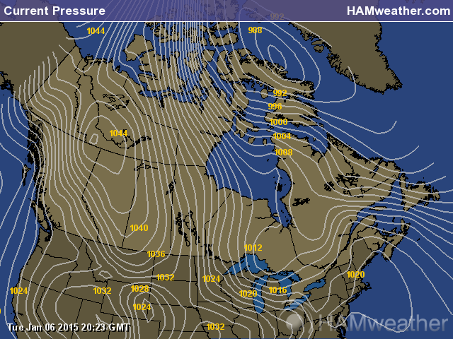
Currently the HP is up to 1046mb over the NW Territories in Canada.

Image
0 likes   

User avatar
Rgv20
S2K Supporter
S2K Supporter
Posts: 2466
Age: 39
Joined: Wed Jan 05, 2011 5:42 pm
Location: Edinburg/McAllen Tx

#2504 Postby Rgv20 » Tue Jan 06, 2015 3:51 pm

17 of the 51 12zECMWF Ensembles (Including the Control Run) has Snow for South Texas ranging from a trace to a couple of inches on Saturday Morning. (Give or take as I'm seeing the forecast stamps of the ensembles on weatherbell)
0 likes   
The following post is NOT an official forecast and should not be used as such. It is just the opinion of the poster and may or may not be backed by sound meteorological data. It is NOT endorsed by any professional institution including storm2k.org For Official Information please refer to the NHC and NWS products.

User avatar
Portastorm
Storm2k Moderator
Storm2k Moderator
Posts: 9914
Age: 63
Joined: Fri Jul 11, 2003 9:16 am
Location: Round Rock, TX
Contact:

Re: Texas Winter 2014-2015

#2505 Postby Portastorm » Tue Jan 06, 2015 3:51 pm

It doesn't look terribly cold up there in Canada at the moment ... except around Hudson Bay and the NW Territories.

Image
0 likes   
Any forecasts under my name are to be taken with a grain of salt. Get your best forecasts from the National Weather Service and National Hurricane Center.

ronyan
S2K Supporter
S2K Supporter
Posts: 791
Age: 39
Joined: Tue Sep 09, 2008 5:46 pm
Location: Lake Jackson, TX

Re: Texas Winter 2014-2015

#2506 Postby ronyan » Tue Jan 06, 2015 3:59 pm

Beaver Creek, Yukon is reporting -43F at the airport. Not terribly cold when the record low for that area of the Yukon is about -80F, but still colder up there than with the last big Arctic front.
0 likes   

User avatar
srainhoutx
S2K Supporter
S2K Supporter
Posts: 6919
Age: 67
Joined: Sun Jan 14, 2007 11:34 am
Location: Haywood County, NC
Contact:

Re: Texas Winter 2014-2015

#2507 Postby srainhoutx » Tue Jan 06, 2015 4:24 pm

SPECIAL WEATHER STATEMENT
NATIONAL WEATHER SERVICE FORT WORTH TX
321 PM CST TUE JAN 6 2015

TXZ091>095-100>107-115>123-129>135-141>148-156>162-174-175-062330-
MONTAGUE-COOKE-GRAYSON-FANNIN-LAMAR-YOUNG-JACK-WISE-DENTON-COLLIN-
HUNT-DELTA-HOPKINS-STEPHENS-PALO PINTO-PARKER-TARRANT-DALLAS-
ROCKWALL-KAUFMAN-VAN ZANDT-RAINS-EASTLAND-ERATH-HOOD-SOMERVELL-
JOHNSON-ELLIS-HENDERSON-COMANCHE-MILLS-HAMILTON-BOSQUE-HILL-
NAVARRO-FREESTONE-ANDERSON-LAMPASAS-CORYELL-BELL-MCLENNAN-FALLS-
LIMESTONE-LEON-MILAM-ROBERTSON-
321 PM CST TUE JAN 6 2015

...WINTER PRECIPITATION POSSIBLE LATER THIS WEEK...

A STRONG ARCTIC COLD FRONT WILL PUSH SOUTH ACROSS NORTH TEXAS ON
WEDNESDAY...BRINGING VERY COLD CONDITIONS TO THE REGION WEDNESDAY
AND THURSDAY. TEMPERATURES WILL BEGIN TO MODIFY LATE
THURSDAY...BUT THEN ANOTHER COLD FRONT WILL MOVE INTO THE NORTHERN
COUNTIES OF NORTH TEXAS THURSDAY NIGHT. THIS FRONT WILL MOVE
THROUGH THE REST OF THE AREA ON FRIDAY. AN UPPER LEVEL DISTURBANCE
WILL APPROACH FROM THE WEST THURSDAY NIGHT AND FRIDAY AS THE FRONT
IS PUSHING SOUTH THROUGH THE AREA. LIFT ASSOCIATED WITH THE COLD
FRONT AND THE UPPER LEVEL DISTURBANCE WILL BE SUFFICIENT FOR LIGHT
PRECIPITATION ACROSS MUCH OF NORTH TEXAS THURSDAY NIGHT THROUGH
THE WEEKEND.

SOME OF THIS COULD FALL IN THE FORM OF WINTRY PRECIPITATION LATE
THURSDAY NIGHT THROUGH SATURDAY WHEN THE COLDEST TEMPERATURES
OCCUR. THE BEST CHANCES WILL LIKELY OCCUR ON FRIDAY...WHEN LIFT
WILL BE STRONGEST ALONG AND NORTH OF THE FRONT. PRECIPITATION
WOULD LIKELY BE IN THE FORM OF LIGHT SNOW ALONG THE RED RIVER...A
MIX OF SLEET AND SNOW ACROSS CENTRAL PORTIONS OF NORTH TEXAS...A
MIX OF RAIN AND SLEET OVER SOUTH-CENTRAL AND SOUTHERN COUNTIES...AND
PREDOMINATELY COLD RAIN OVER THE FAR SOUTHEASTERN COUNTIES. AT
THIS TIME IT DOES NOT APPEAR THAT PRECIPITATION WILL BE SUFFICIENT
FOR WIDESPREAD TRAVEL PROBLEMS....WITH MAINLY TRACE AMOUNTS OF
SNOW AND/OR SLEET ACCUMULATIONS EXPECTED. HOWEVER...THE POTENTIAL
WILL EXIST FOR A HEAVIER BAND OF SLEET/SNOW TO DEVELOP SOMEWHERE
ALONG OR JUST NORTH THE FRONT ON FRIDAY...WHICH COULD PRODUCE
ISOLATED HIGHER ACCUMULATIONS AND LOCALIZED TRAVEL IMPACTS. IT IS
STILL TOO EARLY TO TELL EXACTLY WHERE /OR EVEN IF/ THIS WILL
OCCUR...BUT MORE WILL BE REVEALED AS NEWER DATA ARRIVES OVER THE
NEXT FEW DAYS AND HIGHER RESOLUTION MODELS BEGIN SHEDDING SOME
LIGHT ON THE SPECIFICS OF THE EVENT.

LIGHT WINTER PRECIPITATION AND MINOR TRAVEL IMPACTS MAY LINGER
INTO SATURDAY. PRECIPITATION CHANCES WILL CONTINUE THROUGH
SUNDAY...BUT WARMER AIR MOVING IN AT THE LOWER LEVELS OF THE
ATMOSPHERE SHOULD SWITCH PRECIPITATION TYPE BACK OVER TO COLD
RAIN LATE SATURDAY AND SUNDAY.
0 likes   
Carla/Alicia/Jerry(In The Eye)/Michelle/Charley/Ivan/Dennis/Katrina/Rita/Wilma/Ike/Harvey

Member: National Weather Association
Wx Infinity Forums
http://wxinfinity.com/index.php

Facebook.com/WeatherInfinity
Twitter @WeatherInfinity

aggiecutter
Category 5
Category 5
Posts: 1753
Joined: Thu Oct 14, 2004 9:22 pm
Location: Texarkana

#2508 Postby aggiecutter » Tue Jan 06, 2015 4:26 pm

Confirmed RT @ryanvaughan: Earthquake near Dallas was a magnitude 3.5 pic.twitter.com/aBJyha8ue5
0 likes   

User avatar
wxman57
Moderator-Pro Met
Moderator-Pro Met
Posts: 22984
Age: 67
Joined: Sat Jun 21, 2003 8:06 pm
Location: Houston, TX (southwest)

Re: Texas Winter 2014-2015

#2509 Postby wxman57 » Tue Jan 06, 2015 4:30 pm

Snowman67 wrote:
wxman57 wrote:Looks like mid 30s and an all-day cold rain event for most of Houston on Saturday. No freezing temps so no freezing rain here. Perhaps from Huntsville northward the temps may be closer to freezing or below. Heaviest precip should pass south of Dallas, though the cold air there may be thick enough for a little snow.

Not a good biking day at all.


So you feel pretty confident that the Houston area will not have any icing to deal with?


I'm not worried about icy streets within the city limits of Houston. Perhaps in far NW Harris County and up around Huntsville northward.
0 likes   

User avatar
Portastorm
Storm2k Moderator
Storm2k Moderator
Posts: 9914
Age: 63
Joined: Fri Jul 11, 2003 9:16 am
Location: Round Rock, TX
Contact:

Re: Texas Winter 2014-2015

#2510 Postby Portastorm » Tue Jan 06, 2015 4:34 pm

NWS Fort Worth's afternoon AFD (relevant snippet about possible wintry precip):

MOISTURE AND LIFT WILL BECOME SUFFICIENT FOR THE DEVELOPMENT OF
LIGHT PRECIPITATION LATE THURSDAY NIGHT...WITH A BETTER CHANCES
FRIDAY. COLD ADVECTION BEHIND THE COLD FRONT WILL ENHANCE THE
ALREADY CHILLY AIR IN PLACE ACROSS THE REGION. SUB-FREEZING
TEMPERATURES AT ALL LEVELS OF THE ATMOSPHERE WILL LEAD TO MAINLY
LIGHT SNOW OVER THE NORTHERN-MOST COUNTIES. MODEL SOUNDINGS SUGGEST
THAT A SMALL WARM NOSE MAY PERSIST ALONG THE I-20 CORRIDOR WITH
TEMPERATURES AT OR JUST BELOW FREEZING AT THE SURFACE. THIS WOULD
SUGGEST A SLEET/SNOW MIX ACROSS THE CENTRAL COUNTIES...WITH A LIGHT
RAIN AND SLEET MIX ACROSS THE SOUTHERN THIRD OF THE REGION.

AT THIS TIME...IT APPEARS THAT PRECIPITATION WOULD REMAIN TOO
LIGHT TO GENERATE WIDESPREAD TRAVEL ISSUES FRIDAY AND
SATURDAY...WITH ONLY LIGHT ACCUMULATIONS ANTICIPATED.
HOWEVER...MODELS ARE BEGINNING TO HINT AT THE POTENTIAL FOR A
MESOSCALE SNOW BAND TO DEVELOP SOMEWHERE OVER THE REGION...LIKELY
DUE TO FRONTOGENETIC FORCING ON THE NORTH SIDE OF THE SURFACE
BOUNDARY. IT IS TOO EARLY TO SPECIFY WHERE OR EVEN IF THIS WILL
OCCUR...BUT THIS TYPE OF SCENARIO WOULD HAVE THE POTENTIAL TO
CREATE ISOLATED HIGHER SNOW AND/OR SLEET ACCUMULATIONS AND
LOCALIZED TRAVEL CONCERNS. MORE WILL BE REVEALED AS NEWER DATA
ARRIVES OVER THE NEXT FEW DAYS AND HIGHER RESOLUTION MODELS BEGIN
SHEDDING SOME LIGHT ON THE SPECIFICS OF THE EVENT.

PRECIPITATION WILL TAPER OFF SATURDAY AS THE SHORTWAVE RACES OFF
TO THE NORTHEAST. A SECOND SHORTWAVE ON ITS HEELS WILL BRING
INCREASING CHANCES FOR PRECIPITATION SATURDAY NIGHT AND SUNDAY.
MODEL DATA INDICATES SIGNIFICANTLY WARMER AIR AT THE LOWER LEVELS
OF THE ATMOSPHERE...WHICH WOULD LEAD TO A COLD RAIN. THIS
PRECIPITATION WOULD END FROM WEST TO EAST ON MONDAY AS THE
SHORTWAVE EXITS TO THE EAST OF THE REGION.
0 likes   
Any forecasts under my name are to be taken with a grain of salt. Get your best forecasts from the National Weather Service and National Hurricane Center.

User avatar
dhweather
S2K Supporter
S2K Supporter
Posts: 6199
Joined: Sat Aug 14, 2004 9:29 pm
Location: Heath, TX
Contact:

Re: Texas Winter 2014-2015

#2511 Postby dhweather » Tue Jan 06, 2015 4:36 pm

Image


Come see me, I'd NEVER crush your heart..............
0 likes   
The above post and any post by dhweather is NOT an official forecast and should not be used as such. It is just the opinion of the poster and may or may not be backed by sound meteorological data. It is NOT endorsed by any professional institution including storm2k.org. For official information, please refer to NWS products.

weatherdude1108
Category 5
Category 5
Posts: 4228
Joined: Tue Dec 13, 2011 1:04 pm
Location: Northwest Austin/Cedar Park, TX

#2512 Postby weatherdude1108 » Tue Jan 06, 2015 4:40 pm

Guess it's good the Christmas decorations aren't up anymore. :wink: :flag: :cold:

WWUS84 KEWX 062123
SPSEWX

SPECIAL WEATHER STATEMENT
NATIONAL WEATHER SERVICE AUSTIN/SAN ANTONIO TX
323 PM CST TUE JAN 6 2015

TXZ171>173-183>194-202>209-217>225-228-070330-
LLANO-BURNET-WILLIAMSON-VAL VERDE-EDWARDS-REAL-KERR-BANDERA-
GILLESPIE-KENDALL-BLANCO-HAYS-TRAVIS-BASTROP-LEE-KINNEY-UVALDE-
MEDINA-BEXAR-COMAL-GUADALUPE-CALDWELL-FAYETTE-MAVERICK-ZAVALA-
FRIO-ATASCOSA-WILSON-KARNES-GONZALES-DE WITT-LAVACA-DIMMIT-
INCLUDING THE CITIES OF...LLANO...BURNET...GEORGETOWN...DEL RIO...
ROCKSPRINGS...LEAKEY...KERRVILLE...BANDERA...FREDERICKSBURG...
BOERNE...BLANCO...SAN MARCOS...AUSTIN...BASTROP...GIDDINGS...
BRACKETTVILLE...UVALDE...HONDO...SAN ANTONIO...NEW BRAUNFELS...
SEGUIN...LOCKHART...LA GRANGE...EAGLE PASS...CRYSTAL CITY...
PEARSALL...PLEASANTON...FLORESVILLE...KARNES CITY...GONZALES...
CUERO...HALLETTSVILLE...CARRIZO SPRINGS
323 PM CST TUE JAN 6 2015

...BREEZY AND GUSTY IN THE WAKE OF A POLAR COLD FRONT...

A POLAR COLD FRONT WILL PUSH ACROSS SOUTH CENTRAL TEXAS ON
WEDNESDAY. IN THE WAKE OF THE COLD FRONT...NORTHERLY BREEZY WINDS
OF 15 TO 25 MPH ARE EXPECTED BY MID WEDNESDAY MORNING CONTINUING
THROUGH LATE IN THE AFTERNOON. STRONG GUST WINDS OF 25 TO 40 MPH
ARE POSSIBLE DURING THE AFTERNOON HOURS MAINLY ACROSS THE HILL
COUNTRY AND ALONG THE INTERSTATE 35 CORRIDOR.
0 likes   
The preceding post is NOT an official forecast, and should not be used as such. It is only the opinion of the poster and may or may not be backed by sound meteorological data. It is NOT endorsed by any professional institution including storm2k.org. For Official Information please refer to the NHC and NWS products.

Snowman67
Category 2
Category 2
Posts: 633
Joined: Thu Dec 31, 2009 12:44 pm
Location: Tomball, TX

Re: Texas Winter 2014-2015

#2513 Postby Snowman67 » Tue Jan 06, 2015 4:44 pm

wxman57 wrote:
Snowman67 wrote:
wxman57 wrote:Looks like mid 30s and an all-day cold rain event for most of Houston on Saturday. No freezing temps so no freezing rain here. Perhaps from Huntsville northward the temps may be closer to freezing or below. Heaviest precip should pass south of Dallas, though the cold air there may be thick enough for a little snow.

Not a good biking day at all.


So you feel pretty confident that the Houston area will not have any icing to deal with?


I'm not worried about icy streets within the city limits of Houston. Perhaps in far NW Harris County and up around Huntsville northward.


Thanks Wxman57. I'm NW of the city, in Tomball, where it is often times a degree or so cooler than IAH. Just wanted to get your take...
0 likes   
Any forecast I make is based on my opinion only. Please refer to the NWS or NHC for official forecasts.

User avatar
Tammie
S2K Supporter
S2K Supporter
Posts: 327
Joined: Thu Dec 05, 2013 7:49 am
Location: Sherman, TX

#2514 Postby Tammie » Tue Jan 06, 2015 4:48 pm

What the heck is a "MESOSCALE SNOW BAND" in laymans terms please?
0 likes   
Tammie - Sherman TX

User avatar
gboudx
S2K Supporter
S2K Supporter
Posts: 4080
Joined: Thu Sep 04, 2003 1:39 pm
Location: Rockwall, Tx but from Harvey, La

Re:

#2515 Postby gboudx » Tue Jan 06, 2015 4:52 pm

Tammie wrote:What the heck is a "MESOSCALE SNOW BAND" in laymans terms please?


I think of it like a squall line. Localized enough that not everyone gets the fun, but large enough/intense enough to cause travel problems. If you're under it, enjoy. If not, envy from afar.
Last edited by gboudx on Tue Jan 06, 2015 4:53 pm, edited 1 time in total.
0 likes   

Brent
S2K Supporter
S2K Supporter
Posts: 38099
Age: 37
Joined: Sun May 16, 2004 10:30 pm
Location: Tulsa Oklahoma
Contact:

Re: Texas Winter 2014-2015

#2516 Postby Brent » Tue Jan 06, 2015 4:52 pm

It's basically a localized band that gets a lot of snow with next to nothing elsewhere:

Image
0 likes   
#neversummer

ronyan
S2K Supporter
S2K Supporter
Posts: 791
Age: 39
Joined: Tue Sep 09, 2008 5:46 pm
Location: Lake Jackson, TX

Re: Texas Winter 2014-2015

#2517 Postby ronyan » Tue Jan 06, 2015 4:53 pm

I may be wrong on this but I think Mesoscale there refers to localized banding.
0 likes   

User avatar
gboudx
S2K Supporter
S2K Supporter
Posts: 4080
Joined: Thu Sep 04, 2003 1:39 pm
Location: Rockwall, Tx but from Harvey, La

Re: Texas Winter 2014-2015

#2518 Postby gboudx » Tue Jan 06, 2015 4:54 pm

dhweather wrote:Image


Come see me, I'd NEVER crush your heart..............


Image
0 likes   

User avatar
dhweather
S2K Supporter
S2K Supporter
Posts: 6199
Joined: Sat Aug 14, 2004 9:29 pm
Location: Heath, TX
Contact:

Re:

#2519 Postby dhweather » Tue Jan 06, 2015 4:54 pm

Tammie wrote:What the heck is a "MESOSCALE SNOW BAND" in laymans terms please?


A band of snow in a small geographic scale - only affecting a small localized area. Depending on where it happens, and if it happens, someone could see some snow. 50 miles north/south of where the band sets up, there probably will not be anything.
0 likes   
The above post and any post by dhweather is NOT an official forecast and should not be used as such. It is just the opinion of the poster and may or may not be backed by sound meteorological data. It is NOT endorsed by any professional institution including storm2k.org. For official information, please refer to NWS products.

User avatar
Portastorm
Storm2k Moderator
Storm2k Moderator
Posts: 9914
Age: 63
Joined: Fri Jul 11, 2003 9:16 am
Location: Round Rock, TX
Contact:

Re: Texas Winter 2014-2015

#2520 Postby Portastorm » Tue Jan 06, 2015 5:02 pm

18z GFS rolling in now ... not that I'm a big fan of any 18z model run, but this one looks a bit colder than the 12z run and has frozen precip deeper into south central/south Texas by 12z Saturday.
0 likes   
Any forecasts under my name are to be taken with a grain of salt. Get your best forecasts from the National Weather Service and National Hurricane Center.


Return to “Winter Weather”

Who is online

Users browsing this forum: No registered users and 21 guests