Texas Winter 2014-2015

Winter Weather Discussion

Moderator: S2k Moderators

Forum rules

The posts in this forum are NOT official forecast and should not be used as such. They are just the opinion of the poster and may or may not be backed by sound meteorological data. They are NOT endorsed by any professional institution or STORM2K.

Help Support Storm2K
Message
Author
User avatar
Ntxw
Storm2k Moderator
Storm2k Moderator
Posts: 22791
Joined: Wed Oct 21, 2009 6:34 pm
Location: DFW, Texas

Re: Re:

#2581 Postby Ntxw » Wed Jan 07, 2015 8:43 am

Tammie wrote:
Ntxw wrote:
Tammie wrote:Looks like the NWS FW has moved the North Texas mesoscale snow band further south. Fort Worth and areas slightly south may get in on that fun. Sure liked it better when the Red River and Fort Worth were the effected areas. It put Denton right in the bullseye for some winter fun. Sigh...


Don't feel too bad, its not something that can accurately be predicted until the actual band forms. Lots of time and plus there will be many more chances the next several weeks as the threats keep coming. We have settled into a true winter pattern. Keep knocking anf eventually one will work.


Do you feel the precip predicted is being predicted on the light side by the NWS? I see more winter moisture possibly being available than what they are saying. Am I reading things wrong, or are they erring on the side of caution?


I think they may be right this time with moisture. North Texas is in the deeper cold which tende to be dry, but it won't take much qpf to ring out a nice event with such cold. Southern half of the state is where qpf may be too low. If we miss out because its too cold then later in the weekend when more moisture arrives that may become another problem.
0 likes   
The above post and any post by Ntxw is NOT an official forecast and should not be used as such. It is just the opinion of the poster and may or may not be backed by sound meteorological data. It is NOT endorsed by any professional institution including Storm2k. For official information, please refer to NWS products.

  Help support Storm2K!
Help Support Storm2K

User avatar
srainhoutx
S2K Supporter
S2K Supporter
Posts: 6919
Age: 67
Joined: Sun Jan 14, 2007 11:34 am
Location: Haywood County, NC
Contact:

Re: Texas Winter 2014-2015

#2582 Postby srainhoutx » Wed Jan 07, 2015 8:52 am

Morning briefing from Jeff:

Strong arctic cold front will arrive this morning.

Hard Freeze Warning is in effect for tonight for area north of HWY 105

Wind Advisory in effect all counties this afternoon

Gale Warning in effect all coastal and offshore waters today and tonight

Freezing rain and sleet possible north of a line from Columbus to Livingston Friday night/Saturday.

Discussion:
Massive 1055mb arctic high crashing through the plains with leading edge of the arctic front approaching the northern counties of SE TX. Dense cold air mass is lagging the wind shift by about 3-4 hours and the onset of strong cold air advection and falling temperatures will be midday across SE TX. Very strong winds of 25-35mph with gust to 40mph will onset with the cold air advection especially along and west of I-45 and across the coastal counties. Cold air advection will drive the freezing line southward this afternoon and into SE TX this evening and across nearly all of the area by Thursday morning. Still looking at some mid and high level clouds and gusty winds overnight to help prevent the bottom from falling out of the temperatures…but a widespread freeze is nearly certain at this point. Winds in the 10-15mph range overnight will lower wind chill values into the 10’s across much of the area Thursday morning.

Main forecast concerns this morning as how cold tonight and then how cold this weekend with a secondary surge of arctic air and P-type across the region.

Low Temperatures Thursday Morning:

North of HWY 105: 19-25

North of US 59: 26-30

Inside Beltway 8: 29-32

N of HWY 35: 29-32

Beaches: 32-35

Area north of Hwy 105 will likely experience sub freezing conditions for 8-14 hours with hard freeze conditions of 25 or below for up to 2-6 hours. North of US 59 will likely see freezing temperatures of 6-8 hours.

Precautions for sub-freezing temperatures should be rushed to completion today.

Friday-Saturday:
Weak short wave will cross the area Friday morning with sub freezing temperatures in place. Feel the low level air mass will be very dry and little if any precipitation will reach the ground. If it does it would likely be in the College Station to Livingston area and fall as sleet or sleet/freezing rain mix. Think this is overall a very low threat.

Bigger concern is taking shape for Friday night into Saturday as a stronger short wave and secondary arctic surge moves across the region.

Will have to go ahead and introduce freezing/frozen precipitation into the area for Friday night and Saturday morning. Latest guidance has been trending colder and colder with incoming secondary arctic surge Friday afternoon and now has at least the northern ½ of the area subject to freezing temperatures overnight Friday into Saturday morning. GFS is most aggressive in pushing the surface freezing line to I-10 and even south of that to the west of Houston supporting freezing rain very far south. Other models including the NAM are warmer by a degree or two and keep the precipitation liquid over Harris County.

I am becoming concerned that the models may be under-estimating the incoming cold air slightly since the trend since yesterday has been for colder and colder. Additionally very low dewpoints (25-30) suggest a bit of room for evaporational cooling of the air column to near freezing or below even if guidance temperatures suggest above freezing.

As for P-types warm nose in the mid levels supports a freezing rain sounding with a shallow freezing layer near the surface. Warm air advection processes will attempt to erode this surface freezing layer…but it is going to be hard to do. Could see some sleet mixed with the onset of the precipitation Friday night, but the overall profile is a freezing rain one.

For now will go with freezing rain and sleet mix Friday night into Saturday morning north of a line from Columbus to Conroe to Livingston with some ice accumulation expected on elevated surfaces. Bridges and overpasses will be “very cold” from the hard freeze tonight in this area so ice accumulation on these surface is certainly possible.

Will keep all precipitation south of the Columbus to Livingston line liquid for now, but any additional cooling trends in the model guidance will require the freezing rain line to be adjusted southward close to metro Houston and the I-10 corridor.

Forecasted QPF amounts are concerning especially when dealing with freezing rain as 1-2 inches of liquid are expected over the region from late Friday-Monday. Critical period of Friday night/Saturday morning suggest at least .25-.50 of an inch of liquid QPF across the region and some of this will be in the form of ice across the northern counties. Would like to be more certain on surface temperatures before trying to hammer out ice accumulations.

Not sure temperatures will warm much if at all on Saturday and this could linger freezing rain and ice potential into Saturday night and Sunday allowing greater accumulation amounts across those northern areas.

As with all winter weather events in this area there is a large amount of uncertainty and the difference of 1-2 degrees will make the difference between an ice storm and all rain.
0 likes   
Carla/Alicia/Jerry(In The Eye)/Michelle/Charley/Ivan/Dennis/Katrina/Rita/Wilma/Ike/Harvey

Member: National Weather Association
Wx Infinity Forums
http://wxinfinity.com/index.php

Facebook.com/WeatherInfinity
Twitter @WeatherInfinity

weatherdude1108
Category 5
Category 5
Posts: 4228
Joined: Tue Dec 13, 2011 1:04 pm
Location: Northwest Austin/Cedar Park, TX

Re: Texas Winter 2014-2015

#2583 Postby weatherdude1108 » Wed Jan 07, 2015 8:59 am

Portastorm wrote::uarrow:

And I'm going to make a prediction right now. EWX will eventually lower max temps for Saturday and extend the wintry precip threat throughout the day. Frankly, I don't see us getting above freezing on Saturday. I'm beginning to think this will be a fairly significant event.


I think I agree. It is going to be a challenge to get above freezing Saturday. The source region of this airmass is in the Yukon/Arctic/Canadian region of the globe (continental polar), which tend to be dry . The overrunning of the moist maritime airmass over the dry continental air mass will slowly cool and moisten the air column through evaporative cooling to its dewpoint temp., given enough moisture, delaying any kind of warming IMO.

We are hosting a birthday party on Saturday afternoon between 3 and 5pm. People are supposed to be coming in from San Antonio and Houston. Based on this, I'm wondering if plans need to be changed (??). May be a slow drive in.
0 likes   
The preceding post is NOT an official forecast, and should not be used as such. It is only the opinion of the poster and may or may not be backed by sound meteorological data. It is NOT endorsed by any professional institution including storm2k.org. For Official Information please refer to the NHC and NWS products.

User avatar
srainhoutx
S2K Supporter
S2K Supporter
Posts: 6919
Age: 67
Joined: Sun Jan 14, 2007 11:34 am
Location: Haywood County, NC
Contact:

Re: Texas Winter 2014-2015

#2584 Postby srainhoutx » Wed Jan 07, 2015 9:21 am

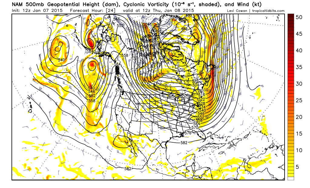
The 12Z NAM continues to suggest a stronger push of cold air arrives Thursday night into Friday morning. What raises an eyebrow are the impressive pressure readings across Alberta and the NW Territory of Canada. The NAM has a strong upper air disturbance dropping S across Alberta that will usher in another strong front. This 250mb upper air flow as well as the 500mb flow pattern is also concerning as it brings a lot of cold air across the North Pole heading S. Also, another major fly in the ointment is a cold string of High pressure ridging from the Ohio Valley back into Texas with that pesky upper low near the Baja Peninsula. That is typically a pattern we see when we get winter weather events across Texas. As Jeff stated, concern is growing that this threat may be legitimate and we really need to closely monitor things today into tomorrow as more information become available as to what our sensible weather may bring.

Image

Image

Image
0 likes   
Carla/Alicia/Jerry(In The Eye)/Michelle/Charley/Ivan/Dennis/Katrina/Rita/Wilma/Ike/Harvey

Member: National Weather Association
Wx Infinity Forums
http://wxinfinity.com/index.php

Facebook.com/WeatherInfinity
Twitter @WeatherInfinity

texas1836
Tropical Storm
Tropical Storm
Posts: 223
Age: 55
Joined: Fri Aug 17, 2012 10:10 am
Location: Ruidoso, New Mexico

#2585 Postby texas1836 » Wed Jan 07, 2015 9:30 am

Information from my weather station (DWC) in the backyard. The temp in McKinney got to 35' and is now sitting at 32' - Wind Speeds between 10 and 16 - Wind Chill at 4'.
0 likes   

User avatar
Ntxw
Storm2k Moderator
Storm2k Moderator
Posts: 22791
Joined: Wed Oct 21, 2009 6:34 pm
Location: DFW, Texas

#2586 Postby Ntxw » Wed Jan 07, 2015 9:30 am

Wind advisory for just about the entire state. No lacking gradient pattern with this arctic air mass. Means business.
0 likes   
The above post and any post by Ntxw is NOT an official forecast and should not be used as such. It is just the opinion of the poster and may or may not be backed by sound meteorological data. It is NOT endorsed by any professional institution including Storm2k. For official information, please refer to NWS products.


  Help support Storm2K!

Help Support Storm2K


User avatar
dhweather
S2K Supporter
S2K Supporter
Posts: 6199
Joined: Sat Aug 14, 2004 9:29 pm
Location: Heath, TX
Contact:

Re:

#2587 Postby dhweather » Wed Jan 07, 2015 9:47 am

Ntxw wrote:Wind advisory for just about the entire state. No lacking gradient pattern with this arctic air mass. Means business.


The wind has some serious teeth and bite to it. Stinging cold.

As wxman57 says, if it's going to be this cold, it may as well snow.
0 likes   
The above post and any post by dhweather is NOT an official forecast and should not be used as such. It is just the opinion of the poster and may or may not be backed by sound meteorological data. It is NOT endorsed by any professional institution including storm2k.org. For official information, please refer to NWS products.

User avatar
Rgv20
S2K Supporter
S2K Supporter
Posts: 2466
Age: 39
Joined: Wed Jan 05, 2011 5:42 pm
Location: Edinburg/McAllen Tx

#2588 Postby Rgv20 » Wed Jan 07, 2015 9:59 am

Winter is coming! NWS in Brownsville saying there is a slight possibility of Sleet for Saturday Morning for parts of Deep South Texas.

URGENT - WINTER WEATHER MESSAGE
NATIONAL WEATHER SERVICE BROWNSVILLE TX
428 AM CST WED JAN 7 2015

...ARCTIC HIGH PRESSURE TO USHER IN LOW WINDS CHILL TONIGHT...

.STRONG AND GUSTY NORTH WINDS TO COMBINE WITH VERY COLD
TEMPERATURES PRODUCING LOW WIND CHILL VALUES LATE TONIGHT AND
THURSDAY MORNING.

TXZ248>257-071830-
/O.NEW.KBRO.WC.Y.0001.150108T0900Z-150108T1600Z/
ZAPATA-JIM HOGG-BROOKS-KENEDY-STARR-HIDALGO-INLAND WILLACY-
INLAND CAMERON-COASTAL WILLACY-COASTAL CAMERON-
INCLUDING THE CITIES OF...ZAPATA...HEBBRONVILLE...FALFURRIAS...
SARITA...RIO GRANDE CITY...ROMA...MCALLEN...EDINBURG...PHARR...
MISSION...WESLACO...RAYMONDVILLE...BROWNSVILLE...HARLINGEN...
PORT MANSFIELD...PORT ISABEL...SOUTH PADRE ISLAND...
LAGUNA HEIGHTS...LAGUNA VISTA
428 AM CST WED JAN 7 2015

...WIND CHILL ADVISORY IN EFFECT FROM 3 AM TO 10 AM CST
THURSDAY...

THE NATIONAL WEATHER SERVICE IN BROWNSVILLE HAS ISSUED A WIND
CHILL ADVISORY...WHICH IS IN EFFECT FROM 3 AM TO 10 AM CST
THURSDAY.

* WIND CHILL VALUES...22 TO 30 DEGREES


* TIMING...FEEL LIKE TEMPERATURES TO FALL BELOW 30 DEGREES AROUND
MIDNIGHT WITH COLDEST WIND CHILLS BETWEEN 3 AND 9 AM THURSDAY.

* IMPACT...DANGEROUSLY COLD WIND CHILL VALUES MAY LEAD TO
HYPOTHERMIA OR FROSTBITE DURING EXTENDED PERIODS ON EXPOSED
SKIN. DRESS IN LAYERS BEFORE VENTURING OUTSIDE. CHILDREN AND
ADULTS STANDING OUTSIDE FOR LONG DURATIONS...SUCH AS AT BUS
STOPS SHOULD TAKE EXTRA PRECAUTIONS TO STAY WARM. PETS AND
LIVESTOCK MAY BECOME STRESSED DUE TO THE COLD TEMPERATURES MAKE
SURE ADEQUATE SHELTER IS AVAILABLE.

PRECAUTIONARY/PREPAREDNESS ACTIONS...

A WIND CHILL ADVISORY IS ISSUED WHEN WIND CHILL INDEX VALUES WILL
DROP TO 30 OR LOWER FOR AT LEAST 2 HOURS FOR THE RIO GRANDE
VALLEY AND 25 DEGREES OR LOWER FOR 2 OR MORE HOURS FOR THE RIO
GRANDE PLAINS AND NORTHERN RANCHLANDS...WITH WINDS OF 10 MPH OR
GREATER.


NWS Brownsville Morning Discussion..

TAKING A LOOK AT MODEL SOUNDINGS AND PROJECTED LOWS
SATURDAY MORNING...IT IS NOT OUT OF THE REALM OF POSSIBILITY FOR A
FEW SLEET PELLETS ACROSS THE NORTHERN RANCHLANDS OF JIM HOGG AND
ZAPATA COUNTIES. CONFIDENCE IS LOW AND HAVE NOT PLACED IN THE GRIDS
AND WILL WATCH WITH SUBSEQUENT SHIFTS.
0 likes   
The following post is NOT an official forecast and should not be used as such. It is just the opinion of the poster and may or may not be backed by sound meteorological data. It is NOT endorsed by any professional institution including storm2k.org For Official Information please refer to the NHC and NWS products.

Snowman67
Category 2
Category 2
Posts: 633
Joined: Thu Dec 31, 2009 12:44 pm
Location: Tomball, TX

Re: Texas Winter 2014-2015

#2589 Postby Snowman67 » Wed Jan 07, 2015 10:00 am

Can someone post a link to a map which shows the current freeze line? Thanks.
0 likes   
Any forecast I make is based on my opinion only. Please refer to the NWS or NHC for official forecasts.

User avatar
RedRiverRefuge
S2K Supporter
S2K Supporter
Posts: 31
Joined: Sun Feb 27, 2011 1:33 pm
Location: West Central Florida

#2590 Postby RedRiverRefuge » Wed Jan 07, 2015 10:26 am

From WPC discussion. Think Far North Texas will miss out on all the winter fun (again)
...SOUTHERN PLAINS/LOWER MS VALLEY...

A BROAD MID LEVEL TROUGH ACROSS NORTHERN MEXICO ON DAY 3 ALLOWS
THE MID LEVEL FLOW OVER THE SOUTHERN PLAINS AND LOWER MS VALLEY TO
BACK. THE BACKING FLOW INTRODUCES MOISTURE UP AND OVER SHALLOW
COLD AIR AT THE SURFACE ACROSS THE REGION...RAISING THE SPECTER OF
FREEZING RAIN STRETCHING FROM CENTRAL TX INTO WEST CENTRAL LA.
THERE IS SOME SPREAD CONCERNING HOW THE MID LEVEL SYSTEM SETS UP
ACROSS THE SOUTHWEST AND NORTHERN MEXICO...AND THIS HAS AN EFFECT
ON HOW MUCH MOISTURE IS DRAWN NORTHWARD ABOVE THE SHALLOW COLD
AIR. IN AN ATTEMPT TO MITIGATE SOME OF THE MODEL SPREAD...THE
THERMAL PORTION OF THE FORECAST WAS BASED ON A BLEND OF THE 00Z
NAM/12Z ECMWF...AND THE QPF WAS BASED ON THE MOST RECENT WPC QPF.

THE BACKING MID LEVEL FLOW OVER THE SOUTHERN PLAINS ALLOWS THE LOW
LEVEL SOUTHWESTERLY FLOW TO TRANSPORTS MOISTURE UP AND OVER THE
SHALLOW COLD AIR IN PLACE ACROSS CENTRAL TX INTO WEST CENTRAL LA.
THE ISENTROPIC LIFT ON THE I290 LEVEL INCREASES MOISTURE IN THE
COLUMN WITH TIME...BUT DRY AIR COMING IN ABOVE THE MOIST LAYER
ROBS THE COLUMN OF ITS ABILITY TO MAKE SNOWFLAKES. MODEL SOUNDINGS
ACROSS EAST CENTRAL TX INTO WEST CENTRAL LA SHOWED A WARM NOSE
BETWEEN 2 AND 3 CELSIUS BETWEEN 825 MB AND 775 MB...WITH BOUNDARY
LAYER TEMPERATURES JUST BELOW FREEZING. ALONG THIS AXIS...ICE
ACCUMULATIONS AS HIGH AS 0.10 INCHES ARE POSSIBLE...BUT GIVEN THE
MODEL DIFFERENCES IT IS NOT CLEAR WHERE THE HIGHEST ICE
ACCUMULATIONS MIGHT BE.

ACROSS CENTRAL TX...MODEL SOUNDINGS ARE LESS DEFINITIVE CONCERNING
PRECIPITATION TYPE. THE 00Z NAM SOUNDING FOR KBWD SHOWED A WARM
NOSE AT ABOUT 800 MB...WITH A MAXIMUM TEMPERATURE IN THE COLUMN OF
ABOUT 1.0 DEGREE CELSIUS. THERE ALSO APPEARS TO BE ICE IN THE
CLOUD...SO A PERIOD OF SNOW/SLEET IS POSSIBLE. AGAIN...DUE TO THE
MODEL SPREAD...THE PRECIPITATION TYPE FORECAST IS BELOW AVERAGE.
0 likes   
This post is NOT AN OFFICIAL FORECAST and should not be used as such. It is just the opinion of the poster and may or may not be backed by sound meteorological data. It is NOT endorsed by any professional institution including storm2k.org. For Official Information please refer to the NHC and NWS products

User avatar
Portastorm
Storm2k Moderator
Storm2k Moderator
Posts: 9914
Age: 63
Joined: Fri Jul 11, 2003 9:16 am
Location: Round Rock, TX
Contact:

Re: Re:

#2591 Postby Portastorm » Wed Jan 07, 2015 10:28 am

Ntxw wrote:I think they may be right this time with moisture. North Texas is in the deeper cold which tende to be dry, but it won't take much qpf to ring out a nice event with such cold. Southern half of the state is where qpf may be too low. If we miss out because its too cold then later in the weekend when more moisture arrives that may become another problem.


On the contrary IMO, the southern half of the state is where the QPF will be the highest not North Texas.
0 likes   
Any forecasts under my name are to be taken with a grain of salt. Get your best forecasts from the National Weather Service and National Hurricane Center.

User avatar
Portastorm
Storm2k Moderator
Storm2k Moderator
Posts: 9914
Age: 63
Joined: Fri Jul 11, 2003 9:16 am
Location: Round Rock, TX
Contact:

Re: Texas Winter 2014-2015

#2592 Postby Portastorm » Wed Jan 07, 2015 11:02 am

12z GFS rolling in now. Interesting to see it is delaying the onset of precipitation in central/south Texas by 6-12 hours on Fri-Sat compared to its 0z run. If this is a trend, it could mean less of an ice storm threat for portions of central, south central, and southeast Texas. Something to watch.
0 likes   
Any forecasts under my name are to be taken with a grain of salt. Get your best forecasts from the National Weather Service and National Hurricane Center.

User avatar
dhweather
S2K Supporter
S2K Supporter
Posts: 6199
Joined: Sat Aug 14, 2004 9:29 pm
Location: Heath, TX
Contact:

Re: Re:

#2593 Postby dhweather » Wed Jan 07, 2015 11:04 am

Portastorm wrote:
Ntxw wrote:I think they may be right this time with moisture. North Texas is in the deeper cold which tende to be dry, but it won't take much qpf to ring out a nice event with such cold. Southern half of the state is where qpf may be too low. If we miss out because its too cold then later in the weekend when more moisture arrives that may become another problem.


On the contrary IMO, the southern half of the state is where the QPF will be the highest not North Texas.


I think NTXW was saying that the models were right for North Texas this time - deeper cold and drier, but the models are underestimating QPF in South Texas.
0 likes   
The above post and any post by dhweather is NOT an official forecast and should not be used as such. It is just the opinion of the poster and may or may not be backed by sound meteorological data. It is NOT endorsed by any professional institution including storm2k.org. For official information, please refer to NWS products.

User avatar
Portastorm
Storm2k Moderator
Storm2k Moderator
Posts: 9914
Age: 63
Joined: Fri Jul 11, 2003 9:16 am
Location: Round Rock, TX
Contact:

Re: Re:

#2594 Postby Portastorm » Wed Jan 07, 2015 11:13 am

dhweather wrote:
Portastorm wrote:
Ntxw wrote:I think they may be right this time with moisture. North Texas is in the deeper cold which tende to be dry, but it won't take much qpf to ring out a nice event with such cold. Southern half of the state is where qpf may be too low. If we miss out because its too cold then later in the weekend when more moisture arrives that may become another problem.


On the contrary IMO, the southern half of the state is where the QPF will be the highest not North Texas.


I think NTXW was saying that the models were right for North Texas this time - deeper cold and drier, but the models are underestimating QPF in South Texas.


Thanks dhweather for clarifying. It's never comfortable for the main PWC office to disagree publicly with our North Texas branch. :wink:

We keep telling him he's good enough to start his own weather forecasting service!
0 likes   
Any forecasts under my name are to be taken with a grain of salt. Get your best forecasts from the National Weather Service and National Hurricane Center.

User avatar
dhweather
S2K Supporter
S2K Supporter
Posts: 6199
Joined: Sat Aug 14, 2004 9:29 pm
Location: Heath, TX
Contact:

#2595 Postby dhweather » Wed Jan 07, 2015 11:36 am

Quick summary of the 12Z GFS and PGFS: Along and North of I-20, cold and DRY.
0 likes   
The above post and any post by dhweather is NOT an official forecast and should not be used as such. It is just the opinion of the poster and may or may not be backed by sound meteorological data. It is NOT endorsed by any professional institution including storm2k.org. For official information, please refer to NWS products.

User avatar
Tammie
S2K Supporter
S2K Supporter
Posts: 327
Joined: Thu Dec 05, 2013 7:49 am
Location: Sherman, TX

Re:

#2596 Postby Tammie » Wed Jan 07, 2015 11:43 am

dhweather wrote:Quick summary of the 12Z GFS and PGFS: Along and North of I-20, cold and DRY.


What are other models showing? The crazy Canadian usually shows us some love...although it stabs us in the back more often than not.
0 likes   
Tammie - Sherman TX

User avatar
wxman57
Moderator-Pro Met
Moderator-Pro Met
Posts: 22985
Age: 67
Joined: Sat Jun 21, 2003 8:06 pm
Location: Houston, TX (southwest)

Re: Texas Winter 2014-2015

#2597 Postby wxman57 » Wed Jan 07, 2015 12:00 pm

Portastorm wrote:12z GFS rolling in now. Interesting to see it is delaying the onset of precipitation in central/south Texas by 6-12 hours on Fri-Sat compared to its 0z run. If this is a trend, it could mean less of an ice storm threat for portions of central, south central, and southeast Texas. Something to watch.


12Z GFS says not as cold (Saturday) and drier. Some very light rain Friday with temps in the mid 30s. No precip Saturday. Rain with temps in the 40s Sunday. No significant frozen precip in TX with the event. Just some spotty freezing/frozen precip central TX to Arkansas. So much variance from from run to run.
0 likes   

User avatar
Tammie
S2K Supporter
S2K Supporter
Posts: 327
Joined: Thu Dec 05, 2013 7:49 am
Location: Sherman, TX

Re: Texas Winter 2014-2015

#2598 Postby Tammie » Wed Jan 07, 2015 12:04 pm

wxman57 wrote:
Portastorm wrote:12z GFS rolling in now. Interesting to see it is delaying the onset of precipitation in central/south Texas by 6-12 hours on Fri-Sat compared to its 0z run. If this is a trend, it could mean less of an ice storm threat for portions of central, south central, and southeast Texas. Something to watch.


12Z GFS says not as cold (Saturday) and drier. Some very light rain Friday with temps in the mid 30s. No precip Saturday. Rain with temps in the 40s Sunday. No significant frozen precip in TX with the event. Just some spotty freezing/frozen precip central TX to Arkansas. So much variance from from run to run.


Do you believe that run?
0 likes   
Tammie - Sherman TX

Stormcenter
S2K Supporter
S2K Supporter
Posts: 6684
Joined: Wed Sep 03, 2003 11:27 am
Location: Houston, TX

Re: Texas Winter 2014-2015

#2599 Postby Stormcenter » Wed Jan 07, 2015 12:05 pm

Probably a blizzard with the next run. :lol:


wxman57 wrote:
Portastorm wrote:12z GFS rolling in now. Interesting to see it is delaying the onset of precipitation in central/south Texas by 6-12 hours on Fri-Sat compared to its 0z run. If this is a trend, it could mean less of an ice storm threat for portions of central, south central, and southeast Texas. Something to watch.


12Z GFS says not as cold (Saturday) and drier. Some very light rain Friday with temps in the mid 30s. No precip Saturday. Rain with temps in the 40s Sunday. No significant frozen precip in TX with the event. Just some spotty freezing/frozen precip central TX to Arkansas. So much variance from from run to run.
0 likes   

User avatar
Ntxw
Storm2k Moderator
Storm2k Moderator
Posts: 22791
Joined: Wed Oct 21, 2009 6:34 pm
Location: DFW, Texas

#2600 Postby Ntxw » Wed Jan 07, 2015 12:07 pm

Meanwhile stations are amassing a cold January average wise. DFW is around 38F so far and will be lower by mid month. Anything below 40F for any month is impressive.
0 likes   
The above post and any post by Ntxw is NOT an official forecast and should not be used as such. It is just the opinion of the poster and may or may not be backed by sound meteorological data. It is NOT endorsed by any professional institution including Storm2k. For official information, please refer to NWS products.


  Help support Storm2K!

Help Support Storm2K


Return to “Winter Weather”

Who is online

Users browsing this forum: No registered users and 21 guests