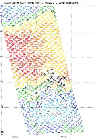
12Z EURO bottoms this out to 935 mb which is the best case scenario...
It is simply too large and systems like this take several days to intensify significantly. GFS says a category 1 type cyclone in 48 hours...
Moderator: S2k Moderators

euro6208 wrote:Ptarmigan wrote:Whoa! The forecast models have 93P with central pressure as low as 869 millibars! That is the most intense on record!


I have never seen any forecast model predict such low pressure.
What record?
Are we align to think that Super Typhoon Tip's 870 mb record in 1979 still stands?
Remember that since 1987, many typhoons stronger than Tip have surpassed in the absence of recon...Including Megi and Haiyan which peaked at 175 knots and for haiyan? maybe 185 knots?
Some people think that comparing atlantic hurricanes and pacific typhoons is modern...


cycloneye wrote:12z GFS still has a very strong cyclone but not with sub 800 MSLP.


euro6208 wrote:
What record?
Are we align to think that Super Typhoon Tip's 870 mb record in 1979 still stands?
Remember that since 1987, many typhoons stronger than Tip have surpassed in the absence of recon...Including Megi and Haiyan which peaked at 175 knots and for haiyan? maybe 185 knots?
Some people think that comparing atlantic hurricanes and pacific typhoons is modern...


1900hurricane wrote:Looks like at least one overshoot in the northeastern complex associated with 93P cleared -100*C at 1801Z.
http://rammb.cira.colostate.edu/product ... 071801.GIF


euro6208 wrote:18Z GFS wallops Vanuatu and peaks at 880 mb.
12Z EURO bottoms this out to 935 mb which is the best case scenario...
It is simply too large and systems like this take several days to intensify significantly. GFS says a category 1 type cyclone in 48 hours...
Users browsing this forum: No registered users and 98 guests