Texas Spring-2015

U.S. & Caribbean Weather Discussions and Severe Weather Events

Moderator: S2k Moderators

Forum rules

The posts in this forum are NOT official forecast and should not be used as such. They are just the opinion of the poster and may or may not be backed by sound meteorological data. They are NOT endorsed by any professional institution or STORM2K.

Help Support Storm2K
Message
Author
User avatar
Tireman4
S2K Supporter
S2K Supporter
Posts: 5853
Age: 59
Joined: Fri Jun 30, 2006 1:08 pm
Location: Humble, Texas
Contact:

Re: Texas Spring-2015

#221 Postby Tireman4 » Wed Apr 08, 2015 2:59 pm

wxman57 wrote:
Tireman4 wrote:
wxman57 wrote:A group of us (including katdaddy from League City) have arrived in Harlingen and are on our way to the National Tropical Weather Conference on S. Padre Island. See the photo below. Srain is on his way down here shortly. Phil Klotzbach is on his flight.

https://imageshack.com/i/pcCbtJk5j


A limo? A limo? Sigh.....LOL...Party time...LOL


Yeah, and it's full of beer. Too bad I don't drink.

https://imageshack.com/i/idywv2Guj


Drunk Mets...oh gracious...we are toast now..LOL
0 likes   

User avatar
vbhoutex
Storm2k Executive
Storm2k Executive
Posts: 29112
Age: 73
Joined: Wed Oct 09, 2002 11:31 pm
Location: Cypress, TX
Contact:

Re: Texas Spring-2015

#222 Postby vbhoutex » Wed Apr 08, 2015 3:18 pm

wxman57 wrote:A group of us (including katdaddy from League City) have arrived in Harlingen and are on our way to the National Tropical Weather Conference on S. Padre Island. See the photo below. Srain is on his way down here shortly. Phil Klotzbach is on his flight.

https://imageshack.com/i/pcCbtJk5j
I see Wxman57, Katdaddy, Mike, Greg(?). Who else is in the pic and how many did I get wrong?I really wanted to be there, but life was not letting it happen this year. Maybe next.
0 likes   
Skywarn, C.E.R.T.
Please click below to donate to STORM2K to help with the expenses of keeping the site going:
Image

User avatar
cycloneye
Admin
Admin
Posts: 145299
Age: 68
Joined: Thu Oct 10, 2002 10:54 am
Location: San Juan, Puerto Rico

Re: Texas Spring-2015

#223 Postby cycloneye » Wed Apr 08, 2015 3:44 pm

wxman57,is a live stream available for the conference? I am interested to hear Phil Klotzbach as he delivers the CSU April forecast.

Not sure what it means, but it says "Live Periscope Broadcast" next to his talk at 9am tomorrow:

http://www.hurricanecenterlive.com/HurricaneCenterLive.com/Schedule.html

Perhaps it'll be streaming on their website (link above)?

Update: Here's something on the Periscope app:
http://newyork.cbslocal.com/2015/04/03/periscope-app-lets-anyone-broadcast-live-but-experts-say-abuse-is-a-threat/

I'll check with the organizers to see if they're going to post a link on the NTWC website in the morning.
0 likes   
Visit the Caribbean-Central America Weather Thread where you can find at first post web cams,radars
and observations from Caribbean basin members Click Here

User avatar
cycloneye
Admin
Admin
Posts: 145299
Age: 68
Joined: Thu Oct 10, 2002 10:54 am
Location: San Juan, Puerto Rico

Re: Texas Spring-2015

#224 Postby cycloneye » Wed Apr 08, 2015 4:03 pm

:uarrow: Link doesn't work.
0 likes   
Visit the Caribbean-Central America Weather Thread where you can find at first post web cams,radars
and observations from Caribbean basin members Click Here

User avatar
wxman57
Moderator-Pro Met
Moderator-Pro Met
Posts: 22978
Age: 67
Joined: Sat Jun 21, 2003 8:06 pm
Location: Houston, TX (southwest)

Re: Texas Spring-2015

#225 Postby wxman57 » Wed Apr 08, 2015 4:16 pm

cycloneye wrote::uarrow: Link doesn't work.


Oops, sorry, clicked "Img" vs. "URL". Fixed now.
0 likes   

weatherdude1108
Category 5
Category 5
Posts: 4228
Joined: Tue Dec 13, 2011 1:04 pm
Location: Northwest Austin/Cedar Park, TX

#226 Postby weatherdude1108 » Wed Apr 08, 2015 4:20 pm

Potentially active weather pattern setting up the next several days.
:rain: :lightning: :rain: :lightning: :rain:

AREA FORECAST DISCUSSION
NATIONAL WEATHER SERVICE AUSTIN/SAN ANTONIO TX
347 PM CDT WED APR 8 2015

.SHORT TERM (TONIGHT THROUGH THURSDAY NIGHT)...

OVERALL HIGHLIGHTS FOR THIS PERIOD WILL FOCUS ON THE ISOLATED TO
SCATTERED STRONG TO SEVERE STORM POSSIBILITIES THURSDAY AFTERNOON
INTO THURSDAY EVENING FOR AREAS GENERALLY ALONG AND NORTH OF A
FREDERICKSBURG TO LA GRANGE LINE.

FOR THURSDAY...THE SHORTWAVE TROUGH OVER UTAH WILL HELP PUSH A
WEAK FRONT TOWARDS THE REGION THAT WILL IMPINGE ON THE
DRYLINE TO EDGE TOWARDS THE HILL COUNTY BY THE AFTERNOON. AFTER
MORNING CLOUD COVER SLOWLY ERODES...SURFACE INSTABILITY IS
PROGGED TO INCREASE TOWARDS 3000 J/KG AS MIXING OCCURS BY MID
AFTERNOON. BOTH NAM/GFS BUFR SOUNDINGS INDICATE THE EROSION OF THE
CAP ACROSS NORTHERN AREAS WITH 30KT 0-6 KM SHEAR IN PLACE. WHILE
NOT SUPER HIGH...THIS AMOUNT IN CONJUNCTION WITH A LOW-LEVEL
FORCING BOUNDARY (DRYLINE) COULD HELP SUPPORT SOME ISOLATED TO
SCATTERED STORMS THAT COULD TAKE ON A SUPERCELL APPEARANCE. MOST
FAVORED AREAS WILL BE TOWARDS WACO TO DALLAS WITH TAIL END CELLS
POSSIBLE TO SKIRT BURNET TO WILLIAMSON. QUARTER SIZED HAIL AND
WIND GUSTS TO 60 MPH WILL BE PRIMARY THREATS.
THIS ACTIVITY WILL
WANE THROUGH THE MID EVENING HOURS AS INSTABILITY DECREASES BUT
MID-LEVEL SHOWERS COULD REGENERATE LATE THURSDAY INTO FRIDAY AS AN
IMPULSE MOVES OVER THE REGION FROM THE WEST. /ALLEN/

&&

.LONG TERM (FRIDAY THROUGH WEDNESDAY)...

AN UNSETTLED PATTERN WILL BE IN PLACE FRIDAY THROUGH NEXT WEEK AS
AREA WILL REMAIN IN SW FLOW WITH EMBEDDED IMPULSES TRAVERSING THE
REGION. THERE WILL BE A CHANCE OF STRONG TO SEVERE STORMS FRIDAY
AND POCKETS OF HEAVY RAIN OVER THE WEEKEND.

FOR FRIDAY...THE WEAK BOUNDARY/DRYLINE WILL BE LOCATED OVER THE
NORTHERN HALF OF THE REGION LEAVING SOUTHERN LOCATIONS IN A MORE
UNSTABLE AIRMASS BY FRIDAY AFTERNOON. THE QUESTION FRIDAY WILL BE
HOW MUCH INSTABILITY WILL OCCUR GIVEN CLOUD COVER FROM MID-LEVEL
LIFT FROM A MORNING TRAVERSING IMPULSE. GLOBAL MODELS INDICATE
RENEWED CONVECTION DURING THE AFTERNOON PER MASS FIELDS WHICH
INCREASES CONFIDENCE OF MORE SURFACE BASED ACTIVITY. SUPPORTIVE
LAPSE RATES AND SHEAR APPEAR TO BE IN PLACE FOR SOME ISOLATED STRONG
TO SEVERE STORMS
WITH MORE FAVORED AREA ACROSS WESTERN AND
SOUTHERN ZONES.

FOR THE WEEKEND...THE BOUNDARY WILL WASH OUT WITH REESTABLISHING
SE LOW-LVL FLOW UNDERNEATH CONTINUED ZONAL TO SW FLOW AS EMBEDDED
IMPULSES TRAVERSE THE REGION. THESE IMPULSES IN COMBINATION WITH
INSTABILITY AND AT LEAST MODEST H5 WIND SPEEDS SHOULD HELP AT
LEAST SCATTERED SHOWER AND THUNDERSTORM GENERATION SATURDAY AND
SUNDAY AFTERNOON. THESE IMPULSES WILL BE EJECTING AHEAD OF A
LARGER CUT-OFF H5 LOW ACROSS NORTHERN MEXICO THAT WILL AID IN
SURFACE LOW DEVELOPMENT INTO MONDAY MORNING ACROSS NORTHERN TEXAS.

FOR EARLY NEXT WEEK...THE NEGATIVELY TILTED TROUGH FROM THE MAIN
LOW WILL PIVOT ACROSS THE REGION AND AID IN LIKELY CONTINUED
SHOWER AND THUNDERSTORM ACTIVITY.
BOTH GFS AND EC PRECIP RUN
ACCUMULATION TOTALS SUGGEST POCKETS OF 4-5 INCHES THROUGH THE END
OF NEXT WEEK. TRENDS WILL NEED TO MONITORED EACH DAY FOR POSSIBLE
FLOODING CONCERNS IF A MORE CONCENTRATED COMPLEX DEVELOPS.
/ALLEN/
0 likes   
The preceding post is NOT an official forecast, and should not be used as such. It is only the opinion of the poster and may or may not be backed by sound meteorological data. It is NOT endorsed by any professional institution including storm2k.org. For Official Information please refer to the NHC and NWS products.

User avatar
TheProfessor
Professional-Met
Professional-Met
Posts: 3506
Age: 28
Joined: Tue Dec 03, 2013 10:56 am
Location: Wichita, Kansas

#227 Postby TheProfessor » Wed Apr 08, 2015 7:07 pm

FWD thought there might be a slight chance of squal line to develop, looks like one has developed in west Texas, I wonder if it will make it to 35?
0 likes   
An alumnus of The Ohio State University.

Your local National Weather Service office is your best source for weather information.

lukem
Tropical Storm
Tropical Storm
Posts: 123
Joined: Wed Feb 17, 2010 2:53 pm

Re: Texas Spring-2015

#228 Postby lukem » Wed Apr 08, 2015 8:01 pm

Just passed over Midland. It was quick, but a nice little rain.
0 likes   

Brent
S2K Supporter
S2K Supporter
Posts: 38088
Age: 36
Joined: Sun May 16, 2004 10:30 pm
Location: Tulsa Oklahoma
Contact:

Re: Texas Spring-2015

#229 Postby Brent » Wed Apr 08, 2015 8:35 pm

Hmmmm

Image

From FWD's evening update

OTHERWISE TOMORROW AFTERNOON AND EVENING LOOK BUSY WEATHER-WISE.
MODEL DATA AND PATTERN RECOGNITION ALL POINT TOWARD SCATTERED TO
NUMEROUS THUNDERSTORMS DEVELOPING ALONG THE FRONT AS IT REACHES A
SHERMAN TO FORT WORTH TO STEPHENVILLE LINE LATE IN THE AFTERNOON.
THE CAP SHOULD BECOME VERY WEAK TO NON-EXISTENT TOMORROW. GIVEN
THE HIGH AMOUNTS OF INSTABILITY...SEVERE WEATHER LOOKS LIKELY IN
OUR CWA AND IT SHOULD BE THE FIRST TIME OUR CWA WILL BE INCLUDED
IN A SEVERE WEATHER WATCH BOX THIS YEAR. LIMITED LOW LEVEL WIND
SHEAR WILL HOPEFULLY KEEP THIS EVENT FROM BECOMING TOO
DANGEROUS...BUT IF PROGGED INSTABILITY VALUES OF 3000+ J/KG DO
COME TRUE...THERE IS PLENTY OF CAPE BELOW 0-3KM TO AID IN NEAR
SURFACE PARCEL ACCELERATION FOR TORNADOGENESIS.
IT IS TOO EARLY
TO DIVE INTO THE MESOSCALE ANALYSIS OF WHAT/WHEN AND WHERE
EXACTLY...AS THESE CLUES WILL BECOME MORE APPARENT TOMORROW WITH
THE AID OF HI-RES SHORT-TERM GUIDANCE AND REAL TIME DATA. SO
OBVIOUSLY WE WILL NEED TO WATCH THIS EVENT UNFOLD VERY CLOSELY DUE
TO THE POTENTIAL FOR SIGNIFICANT IMPACTS.
FOR NOW HAVE UPDATED THE
HWO TO BEEF UP THE WORDING AND IMPACT FOR THE SEVERE WEATHER
THREAT THURSDAY AFTERNOON AND EVENING...BUT INHERITED GRIDS AND
PARAMETERS OF THE SENSIBLE WEATHER FORECAST ALL LOOK GOOD.
0 likes   
#neversummer

WeatherNewbie
Tropical Storm
Tropical Storm
Posts: 231
Joined: Mon Mar 22, 2010 3:42 pm
Location: Richardson, Texas

Re: Texas Spring-2015

#230 Postby WeatherNewbie » Thu Apr 09, 2015 12:37 am

Picture coming out the other side of the front my buddy took driving from DFW to Lubbock tonight.

Image
0 likes   
The above post is NOT an official forecast and should not be used as such. It is just the opinion of the poster and may or may not be backed by sound meteorological data. It is NOT endorsed by any professional institution including storm2k.org. For official information, please refer to NWS products.

JayDT
Category 1
Category 1
Posts: 354
Joined: Tue Dec 16, 2014 12:55 pm
Location: Dallas, Texas

#231 Postby JayDT » Thu Apr 09, 2015 11:18 am

So how's it looking today for the Dallas area?
0 likes   

aggiecutter
Category 5
Category 5
Posts: 1753
Joined: Thu Oct 14, 2004 9:22 pm
Location: Texarkana

Re: Texas Spring-2015

#232 Postby aggiecutter » Thu Apr 09, 2015 12:06 pm

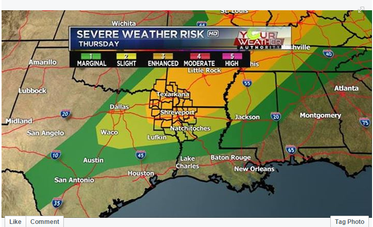
The latest from the SPC:

Image]
0 likes   

User avatar
Portastorm
Storm2k Moderator
Storm2k Moderator
Posts: 9914
Age: 63
Joined: Fri Jul 11, 2003 9:16 am
Location: Round Rock, TX
Contact:

Re: Texas Spring-2015

#233 Postby Portastorm » Thu Apr 09, 2015 2:56 pm

:uarrow:

WeatherNewbie ... love that photo!

I've made that drive into Lubbock myself a few times and the road looks familiar. Out there the weather is big and sometimes entertaining. Speaking of which, I'm hoping to see some good storms and ample rainfall around the AUS area in the next five days.
0 likes   
Any forecasts under my name are to be taken with a grain of salt. Get your best forecasts from the National Weather Service and National Hurricane Center.

Ralph's Weather
S2K Supporter
S2K Supporter
Posts: 3269
Age: 38
Joined: Fri Dec 13, 2013 11:55 am
Location: Lindale, TX
Contact:

#234 Postby Ralph's Weather » Thu Apr 09, 2015 3:26 pm

Storms starting to pop pretty good between Waco and Texarkana.
0 likes   
Follow on Facebook at Ralph's Weather.

aggiecutter
Category 5
Category 5
Posts: 1753
Joined: Thu Oct 14, 2004 9:22 pm
Location: Texarkana

Re: Texas Spring-2015

#235 Postby aggiecutter » Thu Apr 09, 2015 3:26 pm

New event. Tornado Watch from 4/9/2015 3:10 PM to 10:00 PM CDT for Webster County, Marion County, Camp County, De Soto County, Columbia County, Gregg County, Lafayette County, Nevada County, Little River County, Caddo County, Franklin County, Bossier County, Shelby County, Panola County, Cass County, Claiborne County, Hempstead County, Miller County, Rusk County, Harrison County, Bowie County, Titus County, Upshur County, Red River County, Morris County, Bienville County.
0 likes   

aggiecutter
Category 5
Category 5
Posts: 1753
Joined: Thu Oct 14, 2004 9:22 pm
Location: Texarkana

#236 Postby aggiecutter » Thu Apr 09, 2015 3:35 pm

TORNADO WATCH OUTLINE UPDATE FOR WT 43
NWS STORM PREDICTION CENTER NORMAN OK
305 PM CDT THU APR 9 2015

TORNADO WATCH 43 IS IN EFFECT UNTIL 1000 PM CDT FOR THE
FOLLOWING LOCATIONS

TXC037-063-067-073-159-183-203-315-343-347-365-401-419-423-449-
459-499-100300-
/O.NEW.KWNS.TO.A.0043.150409T2005Z-150410T0300Z/

TX
. TEXAS COUNTIES INCLUDED ARE

BOWIE CAMP CASS
CHEROKEE FRANKLIN GREGG
HARRISON MARION MORRIS
NACOGDOCHES PANOLA RUSK
SHELBY SMITH TITUS
UPSHUR WOOD
0 likes   

User avatar
gboudx
S2K Supporter
S2K Supporter
Posts: 4080
Joined: Thu Sep 04, 2003 1:39 pm
Location: Rockwall, Tx but from Harvey, La

#237 Postby gboudx » Thu Apr 09, 2015 3:45 pm

If DFW metro is gonna get thunderstorms, they need to start firing soon. NWS had targeted 4-6pm so we shall see what happens in the next hour or so. One of my sons has a soccer game at 6 in Forney, so we're watching this closely for possible cancellation.
0 likes   

WeatherNewbie
Tropical Storm
Tropical Storm
Posts: 231
Joined: Mon Mar 22, 2010 3:42 pm
Location: Richardson, Texas

#238 Postby WeatherNewbie » Thu Apr 09, 2015 4:20 pm

Looks like something is just now firing off in NW Tarrant.
0 likes   
The above post is NOT an official forecast and should not be used as such. It is just the opinion of the poster and may or may not be backed by sound meteorological data. It is NOT endorsed by any professional institution including storm2k.org. For official information, please refer to NWS products.

Ralph's Weather
S2K Supporter
S2K Supporter
Posts: 3269
Age: 38
Joined: Fri Dec 13, 2013 11:55 am
Location: Lindale, TX
Contact:

#239 Postby Ralph's Weather » Thu Apr 09, 2015 4:36 pm

Storms going strong here though not severe yet. A line is forming over NW N TX.
0 likes   
Follow on Facebook at Ralph's Weather.

gpsnowman
S2K Supporter
S2K Supporter
Posts: 3185
Joined: Fri Jan 07, 2011 10:35 am
Location: Grand Prairie Tx

#240 Postby gpsnowman » Thu Apr 09, 2015 6:48 pm

Another DFW bust? Only thing going on here is my allergies. Man, I miss thunderstorms.
0 likes   


Return to “USA & Caribbean Weather”

Who is online

Users browsing this forum: Google Adsense [Bot], snownado and 7 guests