My first, only and last retweet for this week.. JB bullish now on Niño
@EricBlake12 Its coming.. very similar to 1957-58. MUCH MORE FAVORABLE pattern near Australia this year, tho still likely a bit too strong
ENSO Updates (2007 thru 2023)
Moderator: S2k Moderators
Forum rules

The posts in this forum are NOT official forecasts and should not be used as such. They are just the opinion of the poster and may or may not be backed by sound meteorological data. They are NOT endorsed by any professional institution or STORM2K. For official information, please refer to products from the National Hurricane Center and National Weather Service.
-
xtyphooncyclonex

- Category 5

- Posts: 3891
- Age: 24
- Joined: Sat Dec 08, 2012 9:07 am
- Location: Cebu City
- Contact:
Re: ENSO: CPC weekly update of 4/20/15:El Nino up to +0.9C
0 likes
REMINDER: My opinions that I, or any other NON Pro-Met in this forum, are unofficial. Please do not take my opinions as an official forecast and warning. I am NOT a meteorologist. Following my forecasts blindly may lead to false alarm, danger and risk if official forecasts from agencies are ignored.
-
wxman57

- Moderator-Pro Met

- Posts: 23175
- Age: 68
- Joined: Sat Jun 21, 2003 8:06 pm
- Location: Houston, TX (southwest)
Re: ENSO: CPC weekly update of 4/20/15:El Nino up to +0.9C
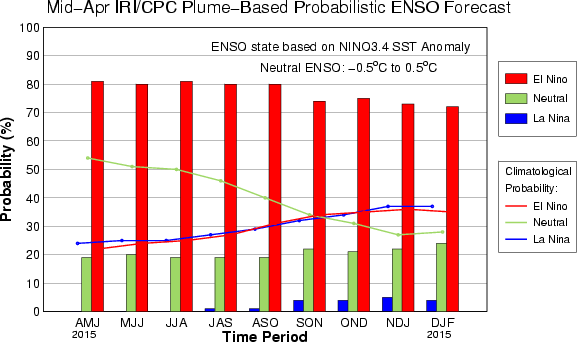
Mid April forecast is up to 80-82% chance of El Nino through the summer. Nino 3.4 region up to 1.2C above normal. La Nina chances are close to the chances of a cold day in hell...
0 likes
-
Kingarabian

- S2K Supporter

- Posts: 16366
- Joined: Sat Aug 08, 2009 3:06 am
- Location: Honolulu, Hawaii
-
cycloneye

- Admin

- Posts: 149511
- Age: 69
- Joined: Thu Oct 10, 2002 10:54 am
- Location: San Juan, Puerto Rico
Re:
Kingarabian wrote:What's warming the Nino regions? I remember last year the very warm sub-surface pool was surfacing but the waters refused to warm. What's the difference now? Lack of dominate Easterlies?
Bingo.
0 likes
Visit the Caribbean-Central America Weather Thread where you can find at first post web cams,radars
and observations from Caribbean basin members Click Here
and observations from Caribbean basin members Click Here
-
Yellow Evan

- Professional-Met

- Posts: 16240
- Age: 27
- Joined: Fri Jul 15, 2011 12:48 pm
- Location: Henderson, Nevada/Honolulu, HI
- Contact:
Re:
Kingarabian wrote:What's warming the Nino regions? I remember last year the very warm sub-surface pool was surfacing but the waters refused to warm. What's the difference now? Lack of dominate Easterlies?
Yes. They are still there, just weaker than normal.
0 likes


Re: Re:
Yellow Evan wrote:Kingarabian wrote:What's warming the Nino regions? I remember last year the very warm sub-surface pool was surfacing but the waters refused to warm. What's the difference now? Lack of dominate Easterlies?
Yes. They are still there, just weaker than normal.
Yeah the normal state is some easterlies, weaken them and you move towards El Nino, WWB excelerates the process. Some weak easterlies may stall the warming next few days but that looks to be it. Westerly wind anomalies take over and wwb may arrive.
0 likes
The above post and any post by Ntxw is NOT an official forecast and should not be used as such. It is just the opinion of the poster and may or may not be backed by sound meteorological data. It is NOT endorsed by any professional institution including Storm2k. For official information, please refer to NWS products.
Help support Storm2K!

Re:
Kingarabian wrote:What's warming the Nino regions? I remember last year the very warm sub-surface pool was surfacing but the waters refused to warm. What's the difference now? Lack of dominate Easterlies?
Yes, the easterlies are weaker than normal - though we aren't seeing westerlies right now. When easterlies are stronger than normal, they can cool the nino regions even in the presence of a warm subsurface. The temperature still decreases with depth, even if the subsurface temps are anomalously warm- so anomalously strong easterlies can still produce cooling or at least slow the rate of warming.
Last year, the strong warm pool was sufficient to warm the ocean to the weak el nino threshold- but lack of atmospheric response allowed the waters to cool back down to neutral. This year we have a similar subsurface warm pool , but with weaker than average easterlies near the dateline.
0 likes
All posts by Dean_175 are NOT official forecasts and should not be used as such. They are just the opinion of the poster and may or may not be backed by sound meteorological data. They are NOT endorsed by any professional institution or storm2k.org. For official information, please refer to the NHC and NWS products.
Ntxw- so will the current state of the MJO, GWO, and SOI that has been positive the past few weeks, "hurt" this el nino at all. Or does it not matter so much because we have westerly wind anomalies at the equator?
0 likes
All posts by Dean_175 are NOT official forecasts and should not be used as such. They are just the opinion of the poster and may or may not be backed by sound meteorological data. They are NOT endorsed by any professional institution or storm2k.org. For official information, please refer to the NHC and NWS products.
-
Kingarabian
- S2K Supporter
- Posts: 16366
- Joined: Sat Aug 08, 2009 3:06 am
- Location: Honolulu, Hawaii
Re:
Dean_175 wrote:Ntxw- so will the current state of the MJO, GWO, and SOI that has been positive the past few weeks, "hurt" this el nino at all. Or does it not matter so much because we have westerly wind anomalies at the equator?
Good question!
I remember the SOI used to be considered a reliable index in measuring ENSO. But last year it would turn really negative and we didn't have a Nino.
I know it's subject to large swings, but it's really interesting since El-Nino is developing despite the index being positive.
0 likes
RIP Kobe Bryant
-
Yellow Evan
- Professional-Met
- Posts: 16240
- Age: 27
- Joined: Fri Jul 15, 2011 12:48 pm
- Location: Henderson, Nevada/Honolulu, HI
- Contact:
Re: Re:
Kingarabian wrote:Dean_175 wrote:Ntxw- so will the current state of the MJO, GWO, and SOI that has been positive the past few weeks, "hurt" this el nino at all. Or does it not matter so much because we have westerly wind anomalies at the equator?
Good question!
I remember the SOI used to be considered a reliable index in measuring ENSO.
It is- but not directly. It is the conditions along the equator that really matter. The equatorial southern oscillation (ESOI) is similar to the SOI - but includes only data in the equatorial regions. ESOI correlates more strongly to nino3.4 than does the SOI, but there is a strong correlation between SOI and ESOI ,- so SOI still matters in that respect, even though it is not actually measuring things along equator. El nino was not declared operationally last year because although SOI was negative, neither the ESOI, equatorial wind anomalies, nor the OLR anomalies indicated a true atmospheric response.
0 likes
All posts by Dean_175 are NOT official forecasts and should not be used as such. They are just the opinion of the poster and may or may not be backed by sound meteorological data. They are NOT endorsed by any professional institution or storm2k.org. For official information, please refer to the NHC and NWS products.
-
xtyphooncyclonex
- Category 5
- Posts: 3891
- Age: 24
- Joined: Sat Dec 08, 2012 9:07 am
- Location: Cebu City
- Contact:
SOI is rising due to the MJO near the Aussie region
0 likes
REMINDER: My opinions that I, or any other NON Pro-Met in this forum, are unofficial. Please do not take my opinions as an official forecast and warning. I am NOT a meteorologist. Following my forecasts blindly may lead to false alarm, danger and risk if official forecasts from agencies are ignored.
-
xtyphooncyclonex
- Category 5
- Posts: 3891
- Age: 24
- Joined: Sat Dec 08, 2012 9:07 am
- Location: Cebu City
- Contact:
Re:
Kingarabian wrote:What's warming the Nino regions? I remember last year the very warm sub-surface pool was surfacing but the waters refused to warm. What's the difference now? Lack of dominate Easterlies?
Another thing is that we had a supertyphoon last March, like in 1997 and 2002. It may have been a product of the strong MJO and greatly reversed the trade winds, together with Cyclone Pam, tropical storms Bavi and Haishen. What is warming now are both the westerlies and a strong downwelling Kelvin Wave.
0 likes
REMINDER: My opinions that I, or any other NON Pro-Met in this forum, are unofficial. Please do not take my opinions as an official forecast and warning. I am NOT a meteorologist. Following my forecasts blindly may lead to false alarm, danger and risk if official forecasts from agencies are ignored.
-
xtyphooncyclonex
- Category 5
- Posts: 3891
- Age: 24
- Joined: Sat Dec 08, 2012 9:07 am
- Location: Cebu City
- Contact:
Re: ENSO: CPC weekly update of 4/20/15:El Nino up to +0.9C
If we calculate the ONI of the weeklies fŕom 04 Feb to 15 Apr, and that the weeklies will continually increase perpetually, then the FMA ONI per calculations would be greater than +0.6°C and much higher values in the next trimonthlies.
0 likes
REMINDER: My opinions that I, or any other NON Pro-Met in this forum, are unofficial. Please do not take my opinions as an official forecast and warning. I am NOT a meteorologist. Following my forecasts blindly may lead to false alarm, danger and risk if official forecasts from agencies are ignored.
-
xtyphooncyclonex
- Category 5
- Posts: 3891
- Age: 24
- Joined: Sat Dec 08, 2012 9:07 am
- Location: Cebu City
- Contact:
JMA favoring a super Niño

0 likes
REMINDER: My opinions that I, or any other NON Pro-Met in this forum, are unofficial. Please do not take my opinions as an official forecast and warning. I am NOT a meteorologist. Following my forecasts blindly may lead to false alarm, danger and risk if official forecasts from agencies are ignored.
-
TeamPlayersBlue

- Category 5
- Posts: 3531
- Joined: Tue Feb 02, 2010 1:44 am
- Location: Denver/Applewood, CO
We see this nino coming. How about the PDO? Warm pool in NE Pac again? Poor california is struggling out west.
0 likes
Personal Forecast Disclaimer:
The posts in this forum are NOT official forecast and should not be used as such. They are just the opinion of the poster and may or may not be backed by sound meteorological data. They are NOT endorsed by any professional institution or storm2k.org. For official information, please refer to the NHC and NWS products.
The posts in this forum are NOT official forecast and should not be used as such. They are just the opinion of the poster and may or may not be backed by sound meteorological data. They are NOT endorsed by any professional institution or storm2k.org. For official information, please refer to the NHC and NWS products.
Re:
TeamPlayersBlue wrote:We see this nino coming. How about the PDO? Warm pool in NE Pac again? Poor california is struggling out west.
PDO will remain positive the rest of this year. Prospect for rainfall in California looks much better this year according to some very very long range guidance. Likely in the form of EPAC activity and then later into the fall and winter. The wettest areas will be the southwest, southern plains, and southeast relative to normal. The stronger the Nino the more likely the wet areas shift westward.
0 likes
The above post and any post by Ntxw is NOT an official forecast and should not be used as such. It is just the opinion of the poster and may or may not be backed by sound meteorological data. It is NOT endorsed by any professional institution including Storm2k. For official information, please refer to NWS products.
Help support Storm2K!
Help support Storm2K!
Re:
Dean_175 wrote:Ntxw- so will the current state of the MJO, GWO, and SOI that has been positive the past few weeks, "hurt" this el nino at all. Or does it not matter so much because we have westerly wind anomalies at the equator?
Those are all pointing to Nina-like tendencies but we've still seen warming. At most I think it's just stalling it, the atmosphere will return to the Nino state in a few weeks. SOI isn't too positive really within neutral range, MJO is incoherent.
0 likes
The above post and any post by Ntxw is NOT an official forecast and should not be used as such. It is just the opinion of the poster and may or may not be backed by sound meteorological data. It is NOT endorsed by any professional institution including Storm2k. For official information, please refer to NWS products.
Help support Storm2K!
Help support Storm2K!
-
cycloneye
- Admin
- Posts: 149511
- Age: 69
- Joined: Thu Oct 10, 2002 10:54 am
- Location: San Juan, Puerto Rico
Re: ENSO Updates
The NHC forecasters continue to harp the strong El Nino case.
Eric Blake @EricBlake12 · 14m 14 minutes ago
The march toward a big #ElNino ? Another notable wly wind burst fcst which appears well-related to the anomalous SSTs

Eric Blake @EricBlake12 · 14m 14 minutes ago
The march toward a big #ElNino ? Another notable wly wind burst fcst which appears well-related to the anomalous SSTs
0 likes
Visit the Caribbean-Central America Weather Thread where you can find at first post web cams,radars
and observations from Caribbean basin members Click Here
and observations from Caribbean basin members Click Here
-
Kingarabian
- S2K Supporter
- Posts: 16366
- Joined: Sat Aug 08, 2009 3:06 am
- Location: Honolulu, Hawaii
(CNN)Marine life seen swimming in unusual places. Water temperatures warmer than they should be. No snow where there should be feet of it.
Some scientists are saying "The Blob" could be playing a factor.
As monikers go, the blob doesn't sound very worrisome.
But if you're a salmon fisherman in Washington or a California resident hoping to see the end of the drought, the blob could become an enemy of top concern.
A University of Washington climate scientist and his associates have been studying the blob -- a huge area of unusually warm water in the Pacific -- for months.
"In the fall of 2013 and early 2014 we started to notice a big, almost circular mass of water that just didn't cool off as much as it usually did, so by spring of 2014 it was warmer than we had ever seen it for that time of year," said Nick Bond, who works at the Joint Institute for the Study of the Atmosphere and Ocean in Seattle, Washington.
http://www.cnn.com/2015/04/22/us/pacifi ... index.html
0 likes
RIP Kobe Bryant
Who is online
Users browsing this forum: No registered users and 400 guests