


ENSO Updates (2007 thru 2023)
Moderator: S2k Moderators
Forum rules

The posts in this forum are NOT official forecasts and should not be used as such. They are just the opinion of the poster and may or may not be backed by sound meteorological data. They are NOT endorsed by any professional institution or STORM2K. For official information, please refer to products from the National Hurricane Center and National Weather Service.
Latest (a little over a week ago) Jason-2 satellite via sea surface heights depicting an evolving canonical (traditional) El Nino underway.
0 likes
The above post and any post by Ntxw is NOT an official forecast and should not be used as such. It is just the opinion of the poster and may or may not be backed by sound meteorological data. It is NOT endorsed by any professional institution including Storm2k. For official information, please refer to NWS products.
Help support Storm2K!
-
Kingarabian

- S2K Supporter

- Posts: 16366
- Joined: Sat Aug 08, 2009 3:06 am
- Location: Honolulu, Hawaii
Re:
Ntxw wrote:Latest (a little over a week ago) Jason-2 satellite via sea surface heights depicting an evolving canonical (traditional) El Nino underway.
The CFS seems to have a very strong Nino event that doesn't seem traditional but not Modoki either.
From the 2015 Indicators thread:

0 likes
RIP Kobe Bryant
Re: Re:
Kingarabian wrote:Ntxw wrote:Latest (a little over a week ago) Jason-2 satellite via sea surface heights depicting an evolving canonical (traditional) El Nino underway.
The CFS seems to have a very strong Nino event that doesn't seem traditional but not Modoki either.
From the 2015 Indicators thread:
http://imageshack.com/a/img537/1790/80pQlU.gif
No two ENSO events are the same. They generally have warmest waters spread somewhere else compared another overall; that look is more of a traditional El Nino, with the eastern Basins warmer than the western basins. A true blue modoki would be warm near the dateline and cold off SA. It's not always perfect sometimes a iittle in between. But it looks big enough and warm enough east to couple with a traditional Nino, Unless we start seeing the coast of SA showing cold water.
Typical Traditional

Typical Modoki

0 likes
The above post and any post by Ntxw is NOT an official forecast and should not be used as such. It is just the opinion of the poster and may or may not be backed by sound meteorological data. It is NOT endorsed by any professional institution including Storm2k. For official information, please refer to NWS products.
Help support Storm2K!
Help support Storm2K!
-
TeamPlayersBlue

- Category 5

- Posts: 3531
- Joined: Tue Feb 02, 2010 1:44 am
- Location: Denver/Applewood, CO
If that pans out, this winter would look pretty similar to this one but wetter?
0 likes
Personal Forecast Disclaimer:
The posts in this forum are NOT official forecast and should not be used as such. They are just the opinion of the poster and may or may not be backed by sound meteorological data. They are NOT endorsed by any professional institution or storm2k.org. For official information, please refer to the NHC and NWS products.
The posts in this forum are NOT official forecast and should not be used as such. They are just the opinion of the poster and may or may not be backed by sound meteorological data. They are NOT endorsed by any professional institution or storm2k.org. For official information, please refer to the NHC and NWS products.
Re: ENSO Updates
TeamPlayersBlue wrote:If that pans out, this winter would look pretty similar to this one but wetter?
If it truly panned out everyone east of the Mississippi would torch, like 98 http://www1.ncdc.noaa.gov/pub/data/tech ... tr9802.pdf, but I would not bet on it.
0 likes
-
TeamPlayersBlue
- Category 5
- Posts: 3531
- Joined: Tue Feb 02, 2010 1:44 am
- Location: Denver/Applewood, CO
Re: ENSO Updates
xironman wrote:TeamPlayersBlue wrote:If that pans out, this winter would look pretty similar to this one but wetter?
If it truly panned out everyone east of the Mississippi would torch, like 98 http://www1.ncdc.noaa.gov/pub/data/tech ... tr9802.pdf, but I would not bet on it.
Still a warm pool of water off the pacific coast though.
0 likes
Personal Forecast Disclaimer:
The posts in this forum are NOT official forecast and should not be used as such. They are just the opinion of the poster and may or may not be backed by sound meteorological data. They are NOT endorsed by any professional institution or storm2k.org. For official information, please refer to the NHC and NWS products.
The posts in this forum are NOT official forecast and should not be used as such. They are just the opinion of the poster and may or may not be backed by sound meteorological data. They are NOT endorsed by any professional institution or storm2k.org. For official information, please refer to the NHC and NWS products.

Ntxw- do you think this WWB is strong enough to increase the chance of a strong el nino this year?
0 likes
All posts by Dean_175 are NOT official forecasts and should not be used as such. They are just the opinion of the poster and may or may not be backed by sound meteorological data. They are NOT endorsed by any professional institution or storm2k.org. For official information, please refer to the NHC and NWS products.
-
xtyphooncyclonex

- Category 5
- Posts: 3891
- Age: 24
- Joined: Sat Dec 08, 2012 9:07 am
- Location: Cebu City
- Contact:
1997 had Isa
This year has Maysak, Noul and GFS & ECMWF show cat 5 Dolphin
This year has Maysak, Noul and GFS & ECMWF show cat 5 Dolphin
0 likes
REMINDER: My opinions that I, or any other NON Pro-Met in this forum, are unofficial. Please do not take my opinions as an official forecast and warning. I am NOT a meteorologist. Following my forecasts blindly may lead to false alarm, danger and risk if official forecasts from agencies are ignored.

Re:
Dean_175 wrote:Ntxw- do you think this WWB is strong enough to increase the chance of a strong el nino this year?
I'd say it does. Very rarely do you get the weekly readings as high as we are this early without one or at the very least borderline moderate-strong almost in every case. The WWB maybe not warm significantly at the surface, however the CFSv2 has done a good job a month in advance in predicting below the surface warm pool movement. It's been calling for a surge of strengthening by June. I was skeptical waiting for the next WWB come May and now that it is happening I'd be a little more confident. This should keep the Nino ~1C or greater for most of the summer.
0 likes
The above post and any post by Ntxw is NOT an official forecast and should not be used as such. It is just the opinion of the poster and may or may not be backed by sound meteorological data. It is NOT endorsed by any professional institution including Storm2k. For official information, please refer to NWS products.
Help support Storm2K!
Help support Storm2K!
-
xtyphooncyclonex
- Category 5
- Posts: 3891
- Age: 24
- Joined: Sat Dec 08, 2012 9:07 am
- Location: Cebu City
- Contact:
Impressive warm-up over the eastern regions Niño 3 & 1+2

0 likes
REMINDER: My opinions that I, or any other NON Pro-Met in this forum, are unofficial. Please do not take my opinions as an official forecast and warning. I am NOT a meteorologist. Following my forecasts blindly may lead to false alarm, danger and risk if official forecasts from agencies are ignored.
-
euro6208
Re:
xtyphooncyclonex wrote:1997 had Isa
This year has Maysak, Noul and GFS & ECMWF show cat 5 Dolphin
Yup usually in a developing nino year, usually the first signs begins in the WPAC and residents feel the onslaught of this event first hand...Strong typhoons in the first half of year promotes more WWB followed by more strong typhoons as depicted by the latest models...This will be a long year for us...
0 likes
Re: ENSO Updates
Looks impressive. Significant warming off South America.
0 likes
All posts by Dean_175 are NOT official forecasts and should not be used as such. They are just the opinion of the poster and may or may not be backed by sound meteorological data. They are NOT endorsed by any professional institution or storm2k.org. For official information, please refer to the NHC and NWS products.
-
cycloneye

- Admin

- Posts: 149511
- Age: 69
- Joined: Thu Oct 10, 2002 10:54 am
- Location: San Juan, Puerto Rico
Re: ENSO Updates
I suspect Typhoon NOUL and soon to be a powerful Typhoon now TD 07W will further cause more west winds to warm things in El Nino areas.
0 likes
Visit the Caribbean-Central America Weather Thread where you can find at first post web cams,radars
and observations from Caribbean basin members Click Here
and observations from Caribbean basin members Click Here
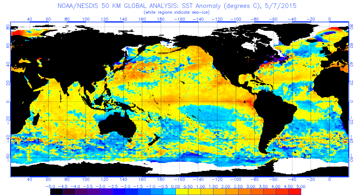
Re: ENSO Updates
Dean_175 wrote:Looks impressive. Significant warming off South America.
http://www.ospo.noaa.gov/data/sst/anoma ... 7.2015.gif
Doesn't look like a wimpy Nino anymore. Another thing to notice is the cold waters North and South of Australia. East and west still a little warm but this should eventually effect the SOI.
0 likes
The above post and any post by Ntxw is NOT an official forecast and should not be used as such. It is just the opinion of the poster and may or may not be backed by sound meteorological data. It is NOT endorsed by any professional institution including Storm2k. For official information, please refer to NWS products.
Help support Storm2K!
Help support Storm2K!
We may get a SHEM cyclone in tandem with the WPAC systems soon. What a westerly windburst, El Nino!
0 likes
The above post and any post by Ntxw is NOT an official forecast and should not be used as such. It is just the opinion of the poster and may or may not be backed by sound meteorological data. It is NOT endorsed by any professional institution including Storm2k. For official information, please refer to NWS products.
Help support Storm2K!
Help support Storm2K!
-
xtyphooncyclonex
- Category 5
- Posts: 3891
- Age: 24
- Joined: Sat Dec 08, 2012 9:07 am
- Location: Cebu City
- Contact:
Re:
Ntxw wrote:We may get a SHEM cyclone in tandem with the WPAC systems soon. What a westerly windburst, El Nino!
Big season coming for the WPAC
So does that mean a better chance of significant surface warming?
0 likes
REMINDER: My opinions that I, or any other NON Pro-Met in this forum, are unofficial. Please do not take my opinions as an official forecast and warning. I am NOT a meteorologist. Following my forecasts blindly may lead to false alarm, danger and risk if official forecasts from agencies are ignored.
-
xtyphooncyclonex
- Category 5
- Posts: 3891
- Age: 24
- Joined: Sat Dec 08, 2012 9:07 am
- Location: Cebu City
- Contact:
1997 and 2015. Same degree of warming over eastern Pacific. Of course, other basins are ahead with El Niño.

0 likes
REMINDER: My opinions that I, or any other NON Pro-Met in this forum, are unofficial. Please do not take my opinions as an official forecast and warning. I am NOT a meteorologist. Following my forecasts blindly may lead to false alarm, danger and risk if official forecasts from agencies are ignored.
More strong WWB coming

0 likes
The above post and any post by Ntxw is NOT an official forecast and should not be used as such. It is just the opinion of the poster and may or may not be backed by sound meteorological data. It is NOT endorsed by any professional institution including Storm2k. For official information, please refer to NWS products.
Help support Storm2K!
Help support Storm2K!
Re:
Ntxw wrote:More strong WWB coming
What about all those strong easterly wind anomalies just to the east of the dateline? Also where can I find this graphic?
0 likes
All posts by Dean_175 are NOT official forecasts and should not be used as such. They are just the opinion of the poster and may or may not be backed by sound meteorological data. They are NOT endorsed by any professional institution or storm2k.org. For official information, please refer to the NHC and NWS products.
Who is online
Users browsing this forum: Kingarabian and 396 guests