Ntxw wrote:MCS
Sinking air won out tonight, I wonder if it will be there tomorrow.
Moderator: S2k Moderators

Ntxw wrote:MCS

Heavy Rainfall Event increasingly likely next week.
Factors, including a slow moving/stalling cool front/surface trough, deep tropical moisture from both the Pacific and Caribbean Sea, and a slow moving upper level storm system, point to a very active period of weather from late Sunday-Friday of next week.
Moisture levels greatly increase Sunday into Monday as a slow moving frontal system stalls across the region Tuesday-Thursday. Expect numerous rounds of heavy thunderstorms with excessive rainfall rates of 2-3 inches per hour or greater. Air mass will be extremely moist and capable of some really big rainfall totals in a short period of time. Threat is there for slow storm motions and cell training making the overall situation worse in the face of widespread excessive rainfall totals over the next 7 days.
Forecasted Rainfall Amounts:
Rainfall amounts Monday-Friday will likely average 4-5 inches with isolated totals of 8-10 inches possible. Current WPC rainfall forecast attached below shows a very large area of excessive rainfall over a large portion of central and SE TX. Should these rainfall totals verify over the middle Colorado River basin, significant improvement would likely occur in the long term hydrologic drought on the Highland Lakes including Lake Travis.
The highest totals will be in strong relation to cell training and this is impossible to determine much more than a few hours in advance.
There is some potential for the trough axis to morph into a closed 850mb low over central TX toward the middle of the week. Such systems in a very tropical air mass can act like a decaying tropical cyclone and take on the daily rainfall pattern of intense nocturnal rainfall events in the late evening and early morning hours near/around the low center at which time the center of any such low pressure would become critical in forecasting where the greatest rainfall would likely occur.
Hydro:
Harris County watersheds are near base flow today and will likely be near base flow at the onset of the rainfall at some point on Monday. Repeated rounds of storms will raise watershed levels over time, but the main question is how long are the breaks between rounds and does any cell training setup over Harris County. Short term rainfall rates of 2-3 inches per hour support urban street flooding and ponding and this will be possible all week.
Rivers:
Area rivers are already high from the recent rainfall especially the Brazos and Trinity and the forecasted rainfall amounts and widespread nature of the event will support significant rises on area rivers with some likely going above flood stage. Only the San Jacinto River affects Harris County however persons traveling outside of Harris County especially toward central TX should be aware of the river/flash flood threat and messaging should encourage “Turn around don’t drown” as this is the type of rainfall setup that has in the past resulted in loss of life in normally dry river bottoms in central TX and at low water crossings.
Tides:
ESE fetch has really increased overnight in response to lowering pressures over NW TX. Nearshore buoys have been running 20-25mph this morning and this has resulted in higher than expected waves along the Gulf beaches. Tides are already running about 1-1.5 feet above normal and when combined with the current lunar cycle total water levels along the Gulf beaches and in Galveston Bay are nearing 3.0 ft. Currently the Galveston North Jetty is running at 2.6ft and Morgan’s Point is 1.6ft. There has been some wave run-up on Bolivar this morning pushing water levels near the top of the beaches. For the most part tides will remain at or below the 3.0 ft mark today and Sunday. Winds will weaken as the frontal boundary approaches Monday and this should begin to slowly lower tide levels.
Forecasted Rainfall Totals (Next 7 Days):


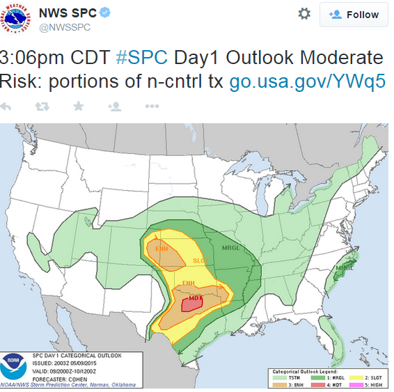
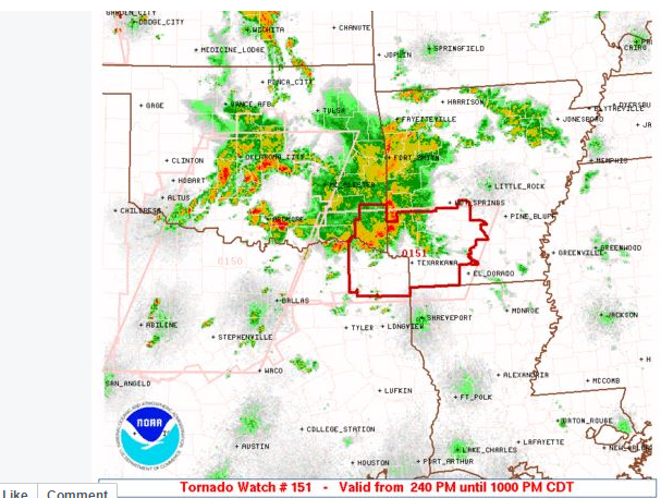
Brent wrote:10% tornado for most of N TX now:


Return to “USA & Caribbean Weather”
Users browsing this forum: Brent and 242 guests