
Texas Spring-2015
Moderator: S2k Moderators
Forum rules

The posts in this forum are NOT official forecast and should not be used as such. They are just the opinion of the poster and may or may not be backed by sound meteorological data. They are NOT endorsed by any professional institution or STORM2K.
-
Rgv20

- S2K Supporter

- Posts: 2466
- Age: 39
- Joined: Wed Jan 05, 2011 5:42 pm
- Location: Edinburg/McAllen Tx
Meanwhile Rain and more Rain...Currently in a Flash Flood Warning and Severe Thunderstorm Warning!!
0 likes
The following post is NOT an official forecast and should not be used as such. It is just the opinion of the poster and may or may not be backed by sound meteorological data. It is NOT endorsed by any professional institution including storm2k.org For Official Information please refer to the NHC and NWS products.
-
Texas Snowman

- Storm2k Moderator

- Posts: 6197
- Joined: Fri Jan 25, 2008 11:29 am
- Location: Denison, Texas
Texoma is less than a half foot from going over it's 640.00 feet above sea level spillway level.
And with all of the flooding rains tonight in Oklahoma and out west towards the Falls, who knows how many feet over the spillway the water may eventually go. A foot or two? Two to four feet? Five feet or more?
FWIW, the current record for Texoma's lake level came during the flood of May 1990 when the lake peaked at 644.76 feet above sea level.
0 likes
The above post and any post by Texas Snowman is NOT an official forecast and should not be used as such. It is just the opinion of the poster and may or may not be backed by sound meteorological data. It is NOT endorsed by any professional institution including storm2k.org. For official information, please refer to NWS products.
Re: Texas Spring-2015
1146PM: A Flash Flood EMERGENCY has been declared for southern Hays County including Wimberley. Blanco River at Wimberley has riven 12 FEET in 30 minutes and will continue to rapidly rise. Numerous homes are flooded and being evacuated. This is a life-threatening situation!
0 likes
-
weatherdude1108
- Category 5

- Posts: 4228
- Joined: Tue Dec 13, 2011 1:04 pm
- Location: Northwest Austin/Cedar Park, TX
Re:
Ntxw wrote::uarrow: We are living through something very unusual. Years from now we'll look back reading NWS articles about the Flood of 2015. When dramatic drought and extremely low lake levels in the matter of months quickly went the other way. April broke way and May the skies opened and relentlessly rained for days on end. Near stage 5 restrictions in the Falls to evacuating thousands of homes in the very place that was dry as a bone. Will be quite a read.
Speaking of Lake Kickapoo! Dramatic rise from around 27 percent capacity to 100 percent capacity. isn't this the lake they had been putting anti evaporation dispersant in?
http://www.waterdatafortexas.org/reserv ... l/kickapoo
Last edited by weatherdude1108 on Sun May 24, 2015 12:00 am, edited 1 time in total.
0 likes
The preceding post is NOT an official forecast, and should not be used as such. It is only the opinion of the poster and may or may not be backed by sound meteorological data. It is NOT endorsed by any professional institution including storm2k.org. For Official Information please refer to the NHC and NWS products.
-
Rgv20
- S2K Supporter
- Posts: 2466
- Age: 39
- Joined: Wed Jan 05, 2011 5:42 pm
- Location: Edinburg/McAllen Tx
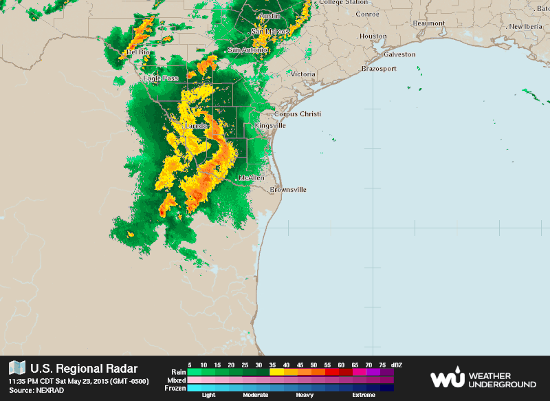
FLASH FLOOD WARNING
TXC047-247-427-240645-
/O.NEW.KBRO.FF.W.0030.150524T0454Z-150524T0645Z/
/00000.0.ER.000000T0000Z.000000T0000Z.000000T0000Z.OO/
BULLETIN - EAS ACTIVATION REQUESTED
FLASH FLOOD WARNING
NATIONAL WEATHER SERVICE BROWNSVILLE TX
1154 PM CDT SAT MAY 23 2015
THE NATIONAL WEATHER SERVICE IN BROWNSVILLE HAS ISSUED A
* FLASH FLOOD WARNING FOR...
SOUTHERN JIM HOGG COUNTY IN DEEP SOUTH TEXAS...
SOUTH CENTRAL BROOKS COUNTY IN DEEP SOUTH TEXAS...
STARR COUNTY IN DEEP SOUTH TEXAS...
* UNTIL 145 AM CDT
* AT 1151 PM CDT...DOPPLER RADAR INDICATED A THUNDERSTORM PRODUCING
HEAVY RAIN ACROSS THE WARNED AREA. UP TO TWO INCHES OF RAIN HAVE
ALREADY FALLEN. FLASH FLOODING IS EXPECTED TO BEGIN SHORTLY.
* SOME LOCATIONS THAT WILL EXPERIENCE FLOODING INCLUDE...
RIO GRANDE CITY...ROMA...EL SAUZ...LA ROSITA...STARR COUNTY
SHERIFFS OFFICE...VIBORAS...RIO GRANDE CITY FIRE DEPARTMENT...RIO
GRANDE CITY LIBRARY...ROMA CITY HALL...RINGGOLD MIDDLE SCHOOL...
ROMA HIGH SCHOOL...ROMA CITY POLICE DEPARTMENT...ROMA PUBLIC
LIBRARY...ESCOBARES...GARCIASVILLE...RIO GRANDE CITY--ROMA...SAN
RAFAEL RANCH AIRPORT...SANTA CRUZ...NORTH ESCOBARES AND LOS
ALVAREZ.
ADDITIONAL RAINFALL AMOUNTS OF 1 TO 2 INCHES ARE POSSIBLE IN THE
WARNED AREA.
PRECAUTIONARY/PREPAREDNESS ACTIONS...
MOVE TO HIGHER GROUND NOW. ACT QUICKLY TO PROTECT YOUR LIFE.
BE ESPECIALLY CAUTIOUS AT NIGHT WHEN IT IS HARDER TO RECOGNIZE THE
DANGERS OF FLOODING.
TURN AROUND...DONT DROWN WHEN ENCOUNTERING FLOODED ROADS. MOST FLOOD
DEATHS OCCUR IN VEHICLES.
REMAIN ALERT FOR FLOODING EVEN IN LOCATIONS NOT RECEIVING RAIN.
ARROYOS...STREAMS AND RIVERS CAN BECOME RAGING KILLER CURRENTS IN A
MATTER OF MINUTES...EVEN FROM DISTANT RAINFALL.
&&
LAT...LON 2661 9911 2668 9901 2680 9896 2693 9884
2686 9828 2628 9872 2630 9875 2633 9875
2633 9879 2637 9880 2635 9890 2639 9893
2637 9895 2640 9896 2639 9901 2641 9904
2640 9908 2643 9911 2648 9909 2654 9917
$$
CASTILLO
0 likes
The following post is NOT an official forecast and should not be used as such. It is just the opinion of the poster and may or may not be backed by sound meteorological data. It is NOT endorsed by any professional institution including storm2k.org For Official Information please refer to the NHC and NWS products.

With all due respect to 1990/1991, 2004, and 2007, I have never seen such a vast area experience flooding like this. All of those years had regional places get a lot of it. 1990 had the biggest Texoma spill but that was two years in the making with 1989 drenching Oklahoma. The only period with such extensive water up and down the Great Plains was spring of 1957.
0 likes
The above post and any post by Ntxw is NOT an official forecast and should not be used as such. It is just the opinion of the poster and may or may not be backed by sound meteorological data. It is NOT endorsed by any professional institution including Storm2k. For official information, please refer to NWS products.
Help support Storm2K!

Re: Texas Spring-2015
This is pretty insane. It's definitely the most rain I have ever seen. My driveway is basically a small creek now.
0 likes
Re: Texas Spring-2015
Shoshana wrote:1146PM: A Flash Flood EMERGENCY has been declared for southern Hays County including Wimberley. Blanco River at Wimberley has riven 12 FEET in 30 minutes and will continue to rapidly rise. Numerous homes are flooded and being evacuated. This is a life-threatening situation!
Update: Flood stage is 13 ft. Record is 33.3 feet. Currently, 39 feet!
0 likes
-
Texas Snowman
- Storm2k Moderator
- Posts: 6197
- Joined: Fri Jan 25, 2008 11:29 am
- Location: Denison, Texas
@garytx: BREAKING: Calwell County OEM is ordering evacuations of low lying areas along San Marcos River for historic flooding. Shelter at Luling HS
0 likes
The above post and any post by Texas Snowman is NOT an official forecast and should not be used as such. It is just the opinion of the poster and may or may not be backed by sound meteorological data. It is NOT endorsed by any professional institution including storm2k.org. For official information, please refer to NWS products.
-
Texas Snowman
- Storm2k Moderator
- Posts: 6197
- Joined: Fri Jan 25, 2008 11:29 am
- Location: Denison, Texas
@TxStormChasers: BREAKING: Blanco River at Wimberley is now at 39 Feet - 6 feet over the previous record. Catastrophic, life-threatening flood. #txwx
0 likes
The above post and any post by Texas Snowman is NOT an official forecast and should not be used as such. It is just the opinion of the poster and may or may not be backed by sound meteorological data. It is NOT endorsed by any professional institution including storm2k.org. For official information, please refer to NWS products.
-
Texas Snowman
- Storm2k Moderator
- Posts: 6197
- Joined: Fri Jan 25, 2008 11:29 am
- Location: Denison, Texas
@breakingweather: 142 crossings are closed due to flooding in the Austin, TX, area, @ATXfloods said. Radar: http://t.co/mTmuNc3b2R
0 likes
The above post and any post by Texas Snowman is NOT an official forecast and should not be used as such. It is just the opinion of the poster and may or may not be backed by sound meteorological data. It is NOT endorsed by any professional institution including storm2k.org. For official information, please refer to NWS products.
-
Texas Snowman
- Storm2k Moderator
- Posts: 6197
- Joined: Fri Jan 25, 2008 11:29 am
- Location: Denison, Texas
@ounwcm: Midnight - getting reports of multiple people trapped on rooftops in the Rock Creek Subdivision in Cache, OK. So scary. #okwx
0 likes
The above post and any post by Texas Snowman is NOT an official forecast and should not be used as such. It is just the opinion of the poster and may or may not be backed by sound meteorological data. It is NOT endorsed by any professional institution including storm2k.org. For official information, please refer to NWS products.
-
Texas Snowman
- Storm2k Moderator
- Posts: 6197
- Joined: Fri Jan 25, 2008 11:29 am
- Location: Denison, Texas
@keatonfox: 1159 Significant, life-threatening flooding conditions in Norman near Lake Thunderbird area. Multiple high-water rescues in progress. #okwx
0 likes
The above post and any post by Texas Snowman is NOT an official forecast and should not be used as such. It is just the opinion of the poster and may or may not be backed by sound meteorological data. It is NOT endorsed by any professional institution including storm2k.org. For official information, please refer to NWS products.
-
Texas Snowman
- Storm2k Moderator
- Posts: 6197
- Joined: Fri Jan 25, 2008 11:29 am
- Location: Denison, Texas
@stormchaser4850: Developing: MT @BenWalnick: First ever Flash Flood EMERGENCY issued for #Tulsa and the surrounding area. #OKwx http://t.co/aiAR33qQBY
0 likes
The above post and any post by Texas Snowman is NOT an official forecast and should not be used as such. It is just the opinion of the poster and may or may not be backed by sound meteorological data. It is NOT endorsed by any professional institution including storm2k.org. For official information, please refer to NWS products.
-
Texas Snowman
- Storm2k Moderator
- Posts: 6197
- Joined: Fri Jan 25, 2008 11:29 am
- Location: Denison, Texas
@stormchaser4850: Update: Emergency manager reports several mobile homes damaged in earlier #tornado near #Austin #TXwx (8:55 pm CDT) http://t.co/dVT8wHRoEN
0 likes
The above post and any post by Texas Snowman is NOT an official forecast and should not be used as such. It is just the opinion of the poster and may or may not be backed by sound meteorological data. It is NOT endorsed by any professional institution including storm2k.org. For official information, please refer to NWS products.
-
Texas Snowman
- Storm2k Moderator
- Posts: 6197
- Joined: Fri Jan 25, 2008 11:29 am
- Location: Denison, Texas
@stormchaser4850: Developing: Flash #Flood EMERGENCY issued in Hays Co. #TX until 5:15 AM CDT; numerous homes flooded, rescues ongoing http://t.co/cwCyw92Bz7
0 likes
The above post and any post by Texas Snowman is NOT an official forecast and should not be used as such. It is just the opinion of the poster and may or may not be backed by sound meteorological data. It is NOT endorsed by any professional institution including storm2k.org. For official information, please refer to NWS products.
-
Texas Snowman
- Storm2k Moderator
- Posts: 6197
- Joined: Fri Jan 25, 2008 11:29 am
- Location: Denison, Texas
@GuadCoalition: @USGS gage now shows Canyon Lake inflows an amazing 54,000 cfs! After years of drought lake will soon be full.#txwx http://t.co/ut0GDQ8Mjf
0 likes
The above post and any post by Texas Snowman is NOT an official forecast and should not be used as such. It is just the opinion of the poster and may or may not be backed by sound meteorological data. It is NOT endorsed by any professional institution including storm2k.org. For official information, please refer to NWS products.
-
Texas Snowman
- Storm2k Moderator
- Posts: 6197
- Joined: Fri Jan 25, 2008 11:29 am
- Location: Denison, Texas
@statesman: LCRA: Floodgate operations are underway at Max Starcke Dam directing water from Lake Marble Falls into Lake Travis http://t.co/svqhZmTke0
0 likes
The above post and any post by Texas Snowman is NOT an official forecast and should not be used as such. It is just the opinion of the poster and may or may not be backed by sound meteorological data. It is NOT endorsed by any professional institution including storm2k.org. For official information, please refer to NWS products.
-
Texas Snowman
- Storm2k Moderator
- Posts: 6197
- Joined: Fri Jan 25, 2008 11:29 am
- Location: Denison, Texas
@breakingweather: 4.87" of rain in 3 hrs at Wichita Mountains Wildlife Refuge, OK, Mesonet reports: http://t.co/nHcsEhoaUC
0 likes
The above post and any post by Texas Snowman is NOT an official forecast and should not be used as such. It is just the opinion of the poster and may or may not be backed by sound meteorological data. It is NOT endorsed by any professional institution including storm2k.org. For official information, please refer to NWS products.
-
Texas Snowman
- Storm2k Moderator
- Posts: 6197
- Joined: Fri Jan 25, 2008 11:29 am
- Location: Denison, Texas
@NWSNorman: So far this year, NWS Norman has issued 70 flash flood warnings. That's more than the past 4 years combined. #okwx
0 likes
The above post and any post by Texas Snowman is NOT an official forecast and should not be used as such. It is just the opinion of the poster and may or may not be backed by sound meteorological data. It is NOT endorsed by any professional institution including storm2k.org. For official information, please refer to NWS products.
Return to “USA & Caribbean Weather”
Who is online
Users browsing this forum: Cpv17, DallasAg, WaveBreaking and 37 guests