Texas Spring-2015

U.S. & Caribbean Weather Discussions and Severe Weather Events

Moderator: S2k Moderators

Forum rules

The posts in this forum are NOT official forecast and should not be used as such. They are just the opinion of the poster and may or may not be backed by sound meteorological data. They are NOT endorsed by any professional institution or STORM2K.

Help Support Storm2K
Message
Author
User avatar
Ntxw
Storm2k Moderator
Storm2k Moderator
Posts: 22785
Joined: Wed Oct 21, 2009 6:34 pm
Location: DFW, Texas

Re:

#1921 Postby Ntxw » Thu May 28, 2015 6:40 pm

DonWrk wrote:HRRR has continually showed the storm weakening rapidly as they approach I-35 from the west. What is causing this weakening?


Hrrr has been trying to outrun the southern MCS cutting off moisture to the northern end. Hasn't been the case so far on radar, nothern line holding well
0 likes   
The above post and any post by Ntxw is NOT an official forecast and should not be used as such. It is just the opinion of the poster and may or may not be backed by sound meteorological data. It is NOT endorsed by any professional institution including Storm2k. For official information, please refer to NWS products.

  Help support Storm2K!
Help Support Storm2K

Brent
S2K Supporter
S2K Supporter
Posts: 38090
Age: 36
Joined: Sun May 16, 2004 10:30 pm
Location: Tulsa Oklahoma
Contact:

Re: Texas Spring-2015

#1922 Postby Brent » Thu May 28, 2015 7:03 pm

HRRR is also way too slow with the line... the rain is gonna be over by 1am yet it has the line just arriving lol. I can buy it weakening some but it's still gonna be a rain mass at the least.

Time to nowcast
0 likes   
#neversummer

User avatar
TheProfessor
Professional-Met
Professional-Met
Posts: 3506
Age: 28
Joined: Tue Dec 03, 2013 10:56 am
Location: Wichita, Kansas

#1923 Postby TheProfessor » Thu May 28, 2015 7:09 pm

:uarrow: Looks like par of the line might be beginning to train. It will probably be over before 1, but it might last a little longer.
0 likes   
An alumnus of The Ohio State University.

Your local National Weather Service office is your best source for weather information.

User avatar
Ntxw
Storm2k Moderator
Storm2k Moderator
Posts: 22785
Joined: Wed Oct 21, 2009 6:34 pm
Location: DFW, Texas

Re: Texas Spring-2015

#1924 Postby Ntxw » Thu May 28, 2015 7:15 pm

It's quickly putting down 2-3 inches of rain. Will DFW get the 1.36" needed to beat 1982 and propel to the top spot? 1957 will get beat that's almost sure with 0.34" for that at #2.

Image
0 likes   
The above post and any post by Ntxw is NOT an official forecast and should not be used as such. It is just the opinion of the poster and may or may not be backed by sound meteorological data. It is NOT endorsed by any professional institution including Storm2k. For official information, please refer to NWS products.


  Help support Storm2K!

Help Support Storm2K


User avatar
TexasF6
S2K Supporter
S2K Supporter
Posts: 816
Joined: Mon Aug 09, 2004 9:33 pm
Location: Austin, TX

Re: Texas Spring-2015

#1925 Postby TexasF6 » Thu May 28, 2015 7:40 pm

WHERE IS PORTASTORM??? How did we have TORNADOES in ROUND ROCK today??? And NO WARNING!!!???????????? Fix it Porta!!!!!!! WxMan57???!!!! Aggiecutter?!!! Help!! Kxan reported this today!!! I was watching radar.....at the time....heard tremendous thunder and lightening? Heavy rain? But a twister????? Parameters were not on point for a twister (or so I thought) today?!!! This is dangerous folks. :double:
0 likes   

User avatar
TheProfessor
Professional-Met
Professional-Met
Posts: 3506
Age: 28
Joined: Tue Dec 03, 2013 10:56 am
Location: Wichita, Kansas

#1926 Postby TheProfessor » Thu May 28, 2015 7:52 pm

:uarrow: There was a small chance for a Tornado, the only parameter really missing was vertical shear, but an outflow boundary could have replaced the shear.
0 likes   
An alumnus of The Ohio State University.

Your local National Weather Service office is your best source for weather information.

aggiecutter
Category 5
Category 5
Posts: 1753
Joined: Thu Oct 14, 2004 9:22 pm
Location: Texarkana

Re: Texas Spring-2015

#1927 Postby aggiecutter » Thu May 28, 2015 7:55 pm

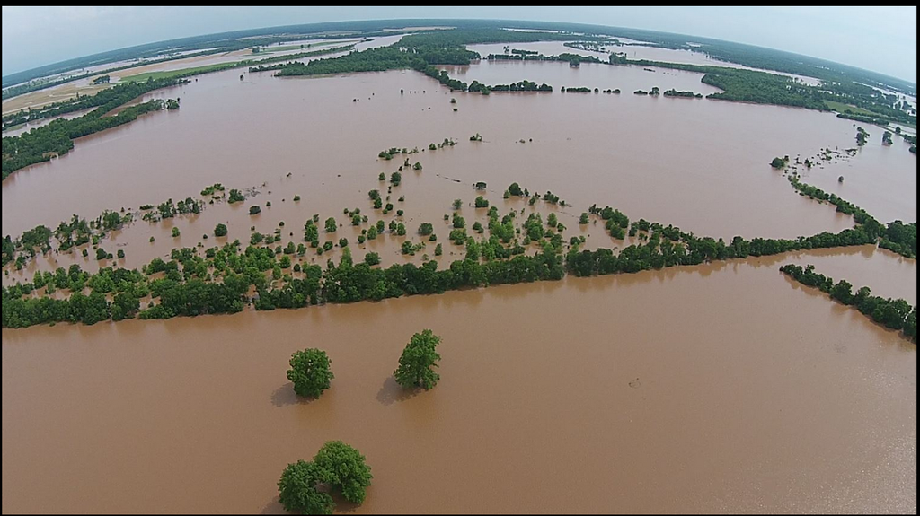
Here is a picture from this afternoon of the flood waters of the Red River just north of Texarkana. The river is expected to rise 2 more feet before cresting on Sunday just north of town.

Image
0 likes   

aggiecutter
Category 5
Category 5
Posts: 1753
Joined: Thu Oct 14, 2004 9:22 pm
Location: Texarkana

Re: Texas Spring-2015

#1928 Postby aggiecutter » Thu May 28, 2015 8:04 pm

TexasF6 wrote:WHERE IS PORTASTORM??? How did we have TORNADOES in ROUND ROCK today??? And NO WARNING!!!???????????? Fix it Porta!!!!!!! WxMan57???!!!! Aggiecutter?!!! Help!! Kxan reported this today!!! I was watching radar.....at the time....heard tremendous thunder and lightening? Heavy rain? But a twister????? Parameters were not on point for a twister (or so I thought) today?!!! This is dangerous folks. :double:


Actually, I talked to Portastorm at a Texarkana eating establishment a couple weeks ago. He told me that he was no longer a weather enthusiast(no snow in Austin for 10 years). He went onto to say that hunting for Bigfoot was his new calling in life, and he was on his way to Fouke, Arkansas(which is 15 miles SE of Texarkana) to find the Fouke Monster(The Legend of Boggy Creek).
0 likes   

Smurfwicked
Tropical Storm
Tropical Storm
Posts: 164
Age: 40
Joined: Mon Sep 03, 2007 7:47 pm
Location: SETX

Re: Texas Spring-2015

#1929 Postby Smurfwicked » Thu May 28, 2015 8:43 pm

Is this going to hold together and make it down here to southeast Texas with more torrential rains like last weekend?
0 likes   

User avatar
Ntxw
Storm2k Moderator
Storm2k Moderator
Posts: 22785
Joined: Wed Oct 21, 2009 6:34 pm
Location: DFW, Texas

Re: Texas Spring-2015

#1930 Postby Ntxw » Thu May 28, 2015 9:46 pm

It is a big state to cover

Image
0 likes   
The above post and any post by Ntxw is NOT an official forecast and should not be used as such. It is just the opinion of the poster and may or may not be backed by sound meteorological data. It is NOT endorsed by any professional institution including Storm2k. For official information, please refer to NWS products.


  Help support Storm2K!

Help Support Storm2K


User avatar
ravyrn
S2K Supporter
S2K Supporter
Posts: 1000
Age: 42
Joined: Sun Aug 31, 2008 5:10 am
Location: Alderbranch, TX

Re: Texas Spring-2015

#1931 Postby ravyrn » Thu May 28, 2015 9:50 pm

Drove to New Braunfels/San Marcos yesterday and back today to move my stepdad's brother into a new assisted living facility. Every river between Jacksonville and there was flooded except for the Blanco and Guadelupe (though evidence of the extreme flooding of the Blanco was present along TX21 and TX80). Once we neared TX80, we saw tons of carpet out on the curb. I was surprised to see most businesses in the flooded area on the west side of the Blanco around the Walmart open and doing business as usual, though you could tell some were sorting through the mess.

I'll post some pictures I took of the rivers on my iPhone as well as some of the 2011 Bastrop forest fire area when I get a chance later tonight or tomorrow. I also have a video of me crossing the Trinity on US 79 west of Palestine. It's a mile wide.
0 likes   

User avatar
ravyrn
S2K Supporter
S2K Supporter
Posts: 1000
Age: 42
Joined: Sun Aug 31, 2008 5:10 am
Location: Alderbranch, TX

Re: Texas Spring-2015

#1932 Postby ravyrn » Thu May 28, 2015 10:10 pm

Here's the video of us crossing the Trinity River just west of Palestine.

I've got a ton of photos I took (quality not great, I forgot the camera so I had to use my iPhone). I'm finishing a contract tonight, but will try to organize them into an album either later tonight or tomorrow.
0 likes   

User avatar
ravyrn
S2K Supporter
S2K Supporter
Posts: 1000
Age: 42
Joined: Sun Aug 31, 2008 5:10 am
Location: Alderbranch, TX

Re: Texas Spring-2015

#1933 Postby ravyrn » Thu May 28, 2015 10:41 pm

Any specific word on that cell near Pumpville? That thing looks intense!

SEVERE WEATHER STATEMENT
NATIONAL WEATHER SERVICE AUSTIN/SAN ANTONIO TX
1035 PM CDT THU MAY 28 2015

TXC137-271-385-463-465-290430-
/O.CON.KEWX.SV.W.0178.000000T0000Z-150529T0430Z/
REAL TX-EDWARDS TX-KINNEY TX-UVALDE TX-VAL VERDE TX-
1035 PM CDT THU MAY 28 2015

...A SEVERE THUNDERSTORM WARNING REMAINS IN EFFECT UNTIL 1130 PM CDT
FOR REAL...SOUTHWESTERN EDWARDS...NORTHERN KINNEY...NORTHWESTERN
UVALDE AND VAL VERDE COUNTIES...

AT 1035 PM CDT...SEVERE THUNDERSTORMS WERE LOCATED ALONG A LINE
EXTENDING FROM 10 MILES NORTHWEST OF LOST MAPLES STATE PARK TO NEAR
VANCE TO 20 MILES NORTH OF ALAMO VILLAGE TO 12 MILES SOUTHWEST OF
CARTA VALLEY TO NEAR COMSTOCK...MOVING SOUTHEAST AT 40 MPH.

HAZARD...60 MPH WIND GUSTS AND PENNY SIZE HAIL.

SOURCE...RADAR INDICATED.

IMPACT...EXPECT DAMAGE TO ROOFS...SIDING AND TREES.

LOCATIONS IMPACTED INCLUDE...
DEL RIO...BRACKETTVILLE...LEAKEY...LANGTRY...LOMA ALTA...COMSTOCK...
JUNO...CAMP WOOD...LAGUNA...MONTELL...ALAMO VILLAGE...CONCAN...
STANDART...LAKE VIEW...AMANDA...PUMPVILLE...VAL VERDE PARK...SEMINOLE
CANYON STATE PARK...BOX CANYON-AMISTAD AND OSMAN.

PRECAUTIONARY/PREPAREDNESS ACTIONS...

FOR YOUR PROTECTION MOVE TO AN INTERIOR ROOM ON THE LOWEST FLOOR OF A
BUILDING.

LARGE HAIL AND DAMAGING WINDS AND CONTINUOUS CLOUD TO GROUND
LIGHTNING IS OCCURRING WITH THESE STORMS. MOVE INDOORS IMMEDIATELY.
LIGHTNING IS ONE OF NATURES LEADING KILLERS. REMEMBER...IF YOU CAN
HEAR THUNDER...YOU ARE CLOSE ENOUGH TO BE STRUCK BY LIGHTNING.

TORRENTIAL RAINFALL IS OCCURRING WITH THESE STORMS...AND MAY LEAD TO
FLASH FLOODING. DO NOT DRIVE YOUR VEHICLE THROUGH FLOODED ROADWAYS.

&&

LAT...LON 3028 10176 3029 10128 2993 10073 2994 9992
3000 9969 2991 9969 2990 9960 2955 9958
2947 9971 2931 10035 2931 10091 2946 10106
2953 10126 2962 10125 2963 10126 2958 10129
2957 10129 2977 10140 2981 10154 2978 10176
TIME...MOT...LOC 0335Z 321DEG 34KT 2997 9969 2980 10005 2970 10046
2966 10082 2966 10112

HAIL...0.75IN
WIND...60MPH
0 likes   

User avatar
ravyrn
S2K Supporter
S2K Supporter
Posts: 1000
Age: 42
Joined: Sun Aug 31, 2008 5:10 am
Location: Alderbranch, TX

Re: Texas Spring-2015

#1934 Postby ravyrn » Thu May 28, 2015 10:43 pm

Ntxw wrote:As of today, all of DFW's supplying reservoirs are 100% full. Bridgeport was the last standout as of last week but has since topped. I'd say watering restrictions will be lowered, but really do we need to? It rains every day or every other...

Image


When was the last time all reservoirs were @ 100%?
0 likes   

User avatar
ravyrn
S2K Supporter
S2K Supporter
Posts: 1000
Age: 42
Joined: Sun Aug 31, 2008 5:10 am
Location: Alderbranch, TX

Re: Texas Spring-2015

#1935 Postby ravyrn » Thu May 28, 2015 10:46 pm

Smurfwicked wrote:Is this going to hold together and make it down here to southeast Texas with more torrential rains like last weekend?


Link to the HRRR. Click the latest run and loop all for its forecast. I'd say you can expect, at the very least, some moderate rain tomorrow morning. I'm no pro or even a seasoned amateur though, so hopefully one of our greats can give you a more detailed and precise answer. But I wouldn't describe the rain you receive in the morning as torrential rains. Though at this point, any rain we get in the state of Texas could cause problems due to how saturated the ground is everywhere.

Personal Forecast Disclaimer:
The posts in this forum are NOT official forecast and should not be used as such. They are just the opinion of the poster and may or may not be backed by sound meteorological data. They are NOT endorsed by any professional institution or storm2k.org. For official information, please refer to the NHC and NWS products.
0 likes   

User avatar
vbhoutex
Storm2k Executive
Storm2k Executive
Posts: 29112
Age: 73
Joined: Wed Oct 09, 2002 11:31 pm
Location: Cypress, TX
Contact:

Re: Texas Spring-2015

#1936 Postby vbhoutex » Thu May 28, 2015 10:47 pm

Smurfwicked wrote:Is this going to hold together and make it down here to southeast Texas with more torrential rains like last weekend?

Currently models are holding the line together till it gets to SE TX/Houston. However, if they are correct it will not be like early this week. Could pick up an inch or so tomorrow morning from the line moving through. Obviously this could change but that was as of 10 pm tonight.
Saturday night to Sunday may be the real deal we need to watch for as some models are showing enough rain to really cause more problems, like up to 3" in some places which NO ONE IN TEXAS needs at this time with most of our rivers above flood stage.
0 likes   
Skywarn, C.E.R.T.
Please click below to donate to STORM2K to help with the expenses of keeping the site going:
Image

User avatar
Texas Snowman
Storm2k Moderator
Storm2k Moderator
Posts: 6179
Joined: Fri Jan 25, 2008 11:29 am
Location: Denison, Texas

#1937 Postby Texas Snowman » Thu May 28, 2015 10:53 pm

Flash flood warnings everywhere to the west of Lake Texoma in the Red River Valley tonight.

The Great Lake Texoma Flood of 2015 continues with no end in sight.

And the lake's flood level record of 644.76 feet above sea level (set in 1990) will be surpassed sometime within the next 12 hours. The big reservoir is currently sitting at 644.39 feet...and rising.

Texoma probably goes past the record sometime before sunrise.

Amazing, just amazing.
0 likes   
The above post and any post by Texas Snowman is NOT an official forecast and should not be used as such. It is just the opinion of the poster and may or may not be backed by sound meteorological data. It is NOT endorsed by any professional institution including storm2k.org. For official information, please refer to NWS products.

User avatar
ravyrn
S2K Supporter
S2K Supporter
Posts: 1000
Age: 42
Joined: Sun Aug 31, 2008 5:10 am
Location: Alderbranch, TX

Re:

#1938 Postby ravyrn » Thu May 28, 2015 10:56 pm

Texas Snowman wrote:Flash flood warnings everywhere to the west of Lake Texoma in the Red River Valley tonight.

The Great Lake Texoma Flood of 2015 continues with no end in sight.

And the lake's flood level record of 644.76 feet above sea level (set in 1990) will be surpassed sometime within the next 12 hours. The big reservoir is currently sitting at 644.39 feet...and rising.

Texoma probably goes past the record sometime before sunrise.

Amazing, just amazing.


Is there still a live feed cam on the spillway? I know someone linked it but trying to wrap up a contract and wrap up my busy week and enjoy a 3 day weekend. If it's still up and someone has it bookmarked, please link so I can check it out in the morning. Thanks!
0 likes   

User avatar
TeamPlayersBlue
Category 5
Category 5
Posts: 3445
Joined: Tue Feb 02, 2010 1:44 am
Location: Denver/Applewood, CO

#1939 Postby TeamPlayersBlue » Thu May 28, 2015 11:34 pm

We had a friend suffer damage yesterday and already my friends are freaking out about this line of storms even though its so far away. Trying to explain meteorology to them is quite difficult though lol
0 likes   
Personal Forecast Disclaimer:
The posts in this forum are NOT official forecast and should not be used as such. They are just the opinion of the poster and may or may not be backed by sound meteorological data. They are NOT endorsed by any professional institution or storm2k.org. For official information, please refer to the NHC and NWS products.

Brent
S2K Supporter
S2K Supporter
Posts: 38090
Age: 36
Joined: Sun May 16, 2004 10:30 pm
Location: Tulsa Oklahoma
Contact:

Re: Texas Spring-2015

#1940 Postby Brent » Thu May 28, 2015 11:40 pm

omg this line is moving so slowwwww. Stilll hasn't reached me yet
0 likes   
#neversummer


Return to “USA & Caribbean Weather”

Who is online

Users browsing this forum: Brent, ElectricStorm and 25 guests