
EPAC: ANDRES - Post-Tropical
Moderator: S2k Moderators
-
cycloneye

- Admin

- Posts: 149276
- Age: 69
- Joined: Thu Oct 10, 2002 10:54 am
- Location: San Juan, Puerto Rico
Re: EPAC: ANDRES - Hurricane
Wow!
0 likes
Visit the Caribbean-Central America Weather Thread where you can find at first post web cams,radars
and observations from Caribbean basin members Click Here
and observations from Caribbean basin members Click Here
-
Yellow Evan

- Professional-Met

- Posts: 16231
- Age: 27
- Joined: Fri Jul 15, 2011 12:48 pm
- Location: Henderson, Nevada/Honolulu, HI
- Contact:
-
HurricaneTracker2031
- Tropical Storm

- Posts: 248
- Age: 26
- Joined: Fri Jul 19, 2013 7:20 pm
- Location: Pembroke Pines, FL, USA
- Contact:
Re: EPAC: ANDRES - Hurricane
Andres made a big surprise when it sustained itself and intensified more. It should hold on for a few more days before it starts to weaken. It looks great now.

Synopsis on Andres and other systems: http://goo.gl/qDDxw6
Personal Forecast Disclaimer:
The posts in this forum are NOT official forecast and should not be used as such. They are just the opinion of the poster and may or may not be backed by sound meteorological data. They are NOT endorsed by any professional institution or storm2k.org. For official information, please refer to the NHC and NWS products.
0 likes
SHORT VERSION OF DISCLAIMER: THIS SITE LINK BELOW IS NOT AN OFFICIAL FORECASTING OFFICE AND SHOULD NOT BE USED TO MAKE ANY EMERGENCY DECISIONS....
http://www.macstropicalweather.weebly.com
http://www.macstropicalweather.weebly.com


Re:
Yellow Evan wrote:And there were doubts by others this system would not reach Category 2.
I never really stopped believing in this system though, and look what happened.
When things are favorable, it cannot be stopped period. The EPAC has been on fire and continues. A worthy first storm predecessor to 2014's Amanda.
0 likes
The above post and any post by Ntxw is NOT an official forecast and should not be used as such. It is just the opinion of the poster and may or may not be backed by sound meteorological data. It is NOT endorsed by any professional institution including Storm2k. For official information, please refer to NWS products.
Help support Storm2K!

-
Yellow Evan
- Professional-Met
- Posts: 16231
- Age: 27
- Joined: Fri Jul 15, 2011 12:48 pm
- Location: Henderson, Nevada/Honolulu, HI
- Contact:
Re: Re:
Ntxw wrote:Yellow Evan wrote:And there were doubts by others this system would not reach Category 2.
I never really stopped believing in this system though, and look what happened.
When things are favorable, it cannot be stopped period. The EPAC has been on fire and continues. A worthy first storm predecessor to 2014's Amanda.
Yep, the EPAC does it AGAIN.
2015 picking up right where it left off.
0 likes
-
Kingarabian

- S2K Supporter

- Posts: 16348
- Joined: Sat Aug 08, 2009 3:06 am
- Location: Honolulu, Hawaii


-
TropicalAnalystwx13

- Category 5

- Posts: 2109
- Age: 28
- Joined: Tue Jul 19, 2011 8:20 pm
- Location: Wilmington, NC
- Contact:
Re:
Kingarabian wrote:
Remarkable hurricane.cycloneye wrote:Wow!
Cat. 5 looks like it's on it's way when you see that and you see that white (super cold tops) almost fully wrapping around the eye:
White is "only" -70C. A general rule of thumb is a ring of -80C convection for Category 5.
0 likes
-
Kingarabian
- S2K Supporter
- Posts: 16348
- Joined: Sat Aug 08, 2009 3:06 am
- Location: Honolulu, Hawaii

-
Kingarabian
- S2K Supporter
- Posts: 16348
- Joined: Sat Aug 08, 2009 3:06 am
- Location: Honolulu, Hawaii
Re: Re:
TropicalAnalystwx13 wrote:White is "only" -70C. A general rule of thumb is a ring of -80C convection for Category 5.
Thanks, I'm getting ahead of myself. Just comparing hurricane rick of 2009:
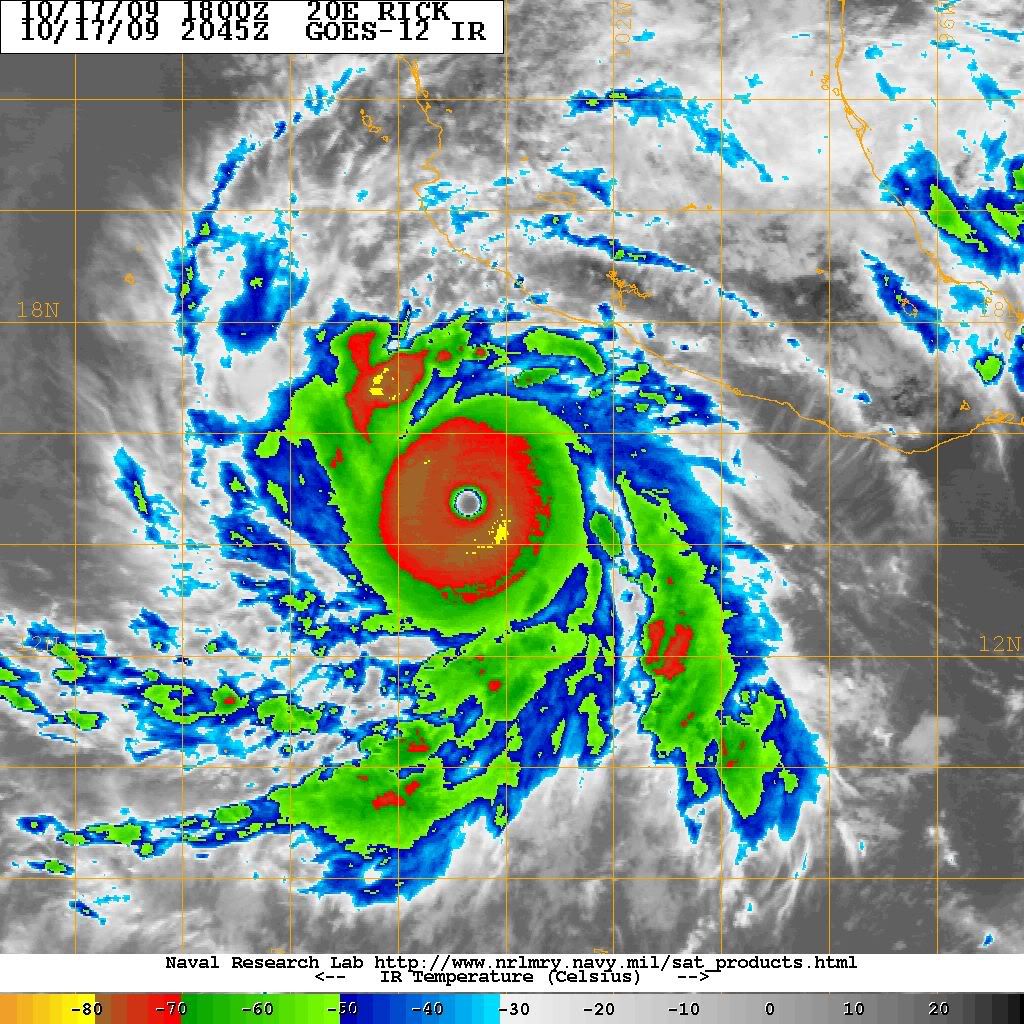
and Andres:

It'll be a remarkable feat if that ring closes up and -80C shoot up.
0 likes
RIP Kobe Bryant
-
Yellow Evan
- Professional-Met
- Posts: 16231
- Age: 27
- Joined: Fri Jul 15, 2011 12:48 pm
- Location: Henderson, Nevada/Honolulu, HI
- Contact:
-
TropicalAnalystwx13
- Category 5
- Posts: 2109
- Age: 28
- Joined: Tue Jul 19, 2011 8:20 pm
- Location: Wilmington, NC
- Contact:
Re: Re:
Kingarabian wrote:TropicalAnalystwx13 wrote:White is "only" -70C. A general rule of thumb is a ring of -80C convection for Category 5.
Thanks, I'm getting ahead of myself. Just comparing hurricane rick of 2009:
It'll be a remarkable feat if that ring closes up and -80C shoot up.
Actually, you were right here. I was actually thinking of the West Pacific and not the Atlantic/East Pacific. It's been a while since the last Category 5, so don't blame me.
A ring of -70C will do in the West Hemisphere if the eye is well-rounded and at least 10C (general statement here). For reference, Marie's eye peaked at 18C while it was a Category 5, whereas Amanda's peaked at 10C while it was a 135kt Category 4.
0 likes
-
Yellow Evan
- Professional-Met
- Posts: 16231
- Age: 27
- Joined: Fri Jul 15, 2011 12:48 pm
- Location: Henderson, Nevada/Honolulu, HI
- Contact:
-
Yellow Evan
- Professional-Met
- Posts: 16231
- Age: 27
- Joined: Fri Jul 15, 2011 12:48 pm
- Location: Henderson, Nevada/Honolulu, HI
- Contact:
Re: Re:
TropicalAnalystwx13 wrote:Kingarabian wrote:TropicalAnalystwx13 wrote:White is "only" -70C. A general rule of thumb is a ring of -80C convection for Category 5.
Thanks, I'm getting ahead of myself. Just comparing hurricane rick of 2009:
It'll be a remarkable feat if that ring closes up and -80C shoot up.
Actually, you were right here. I was actually thinking of the West Pacific and not the Atlantic/East Pacific. It's been a while since the last Category 5, so don't blame me.
A ring of -70C will do in the West Hemisphere if the eye is well-rounded and at least 10C (general statement here). For reference, Marie's eye peaked at 18C while it was a Category 5, whereas Amanda's peaked at 10C while it was a 135kt Category 4.
Eye is 7C right now, so it's not too far off from 10C+
0 likes
-
cycloneye
- Admin
- Posts: 149276
- Age: 69
- Joined: Thu Oct 10, 2002 10:54 am
- Location: San Juan, Puerto Rico
Re: EPAC: ANDRES - Hurricane
HURRICANE ANDRES DISCUSSION NUMBER 16
NWS NATIONAL HURRICANE CENTER MIAMI FL EP012015
800 PM PDT SUN MAY 31 2015
The rather unexpected intensification noted earlier today has
continued into this evening. Andres has a classic presentation on
satellite images, with a well-defined 15 n mi diameter eye embedded
within a symmetric mass of very deep convection. The current
intensity estimate is set at 120 kt, which is a blend of the latest
subjective and objective Dvorak analyses.
Andres continues to move slowly westward, or 270/5 kt, in a weak
steering current. Within 36 hours, the global models show a
mid-tropospheric anticyclone building in the vicinity of the Baja
California peninsula. This should cause Andres to turn toward the
west-northwest and northwest at a slightly faster forward speed.
After 72 hours, a mid-tropospheric trough is predicted to dig near
the longitude of the cyclone. Andres should be rapidly weakening by
that time, however, and will likely not respond much to the flow at
that level. Therefore the official track forecast shows only a
northeastward drift at 96-120 hours. This is similar to the
previous forecast and leans toward the ECMWF model track
Even though Andres has intensified significantly today, the
numerical intensity guidance insists on a weakening trend beginning
soon. The hurricane is likely to encounter a more stable and drier
environment in the next day or two, and sea surface temperatures
will be gradually cooling. The official intensity forecast is
close to the model consensus through 72 hours, and below it
afterwards since the cyclone is likely to be reduced to a remnant
low over quite cool waters by that time.
FORECAST POSITIONS AND MAX WINDS
INIT 01/0300Z 15.3N 119.2W 120 KT 140 MPH
12H 01/1200Z 15.8N 120.2W 110 KT 125 MPH
24H 02/0000Z 16.7N 121.7W 100 KT 115 MPH
36H 02/1200Z 17.7N 123.3W 85 KT 100 MPH
48H 03/0000Z 18.7N 124.9W 65 KT 75 MPH
72H 04/0000Z 20.0N 126.5W 40 KT 45 MPH
96H 05/0000Z 20.5N 126.0W 30 KT 35 MPH...POST-TROP/REMNT LOW
120H 06/0000Z 21.0N 125.5W 25 KT 30 MPH...POST-TROP/REMNT LOW
$$
Forecaster Pasch
0 likes
Visit the Caribbean-Central America Weather Thread where you can find at first post web cams,radars
and observations from Caribbean basin members Click Here
and observations from Caribbean basin members Click Here
-
Yellow Evan
- Professional-Met
- Posts: 16231
- Age: 27
- Joined: Fri Jul 15, 2011 12:48 pm
- Location: Henderson, Nevada/Honolulu, HI
- Contact:

-
Kingarabian
- S2K Supporter
- Posts: 16348
- Joined: Sat Aug 08, 2009 3:06 am
- Location: Honolulu, Hawaii
Re: Re:
TropicalAnalystwx13 wrote:Kingarabian wrote:TropicalAnalystwx13 wrote:White is "only" -70C. A general rule of thumb is a ring of -80C convection for Category 5.
Thanks, I'm getting ahead of myself. Just comparing hurricane rick of 2009:
It'll be a remarkable feat if that ring closes up and -80C shoot up.
Actually, you were right here. I was actually thinking of the West Pacific and not the Atlantic/East Pacific. It's been a while since the last Category 5, so don't blame me.
A ring of -70C will do in the West Hemisphere if the eye is well-rounded and at least 10C (general statement here). For reference, Marie's eye peaked at 18C while it was a Category 5, whereas Amanda's peaked at 10C while it was a 135kt Category 4.
Rick was @ nearly 150kts without a full ring of -80C cloud tops.
Last edited by Kingarabian on Sun May 31, 2015 10:04 pm, edited 1 time in total.
0 likes
RIP Kobe Bryant
-
Kingarabian
- S2K Supporter
- Posts: 16348
- Joined: Sat Aug 08, 2009 3:06 am
- Location: Honolulu, Hawaii
Re: EPAC: ANDRES - Hurricane
Yellow Evan wrote:
OH MY GOD!!!!!!!
Is this really happening?
LOL!!!!!!
0 likes
RIP Kobe Bryant
-
Hurricane Jed

- Category 2

- Posts: 546
- Age: 38
- Joined: Mon Jan 24, 2011 3:36 pm
- Location: Cen Tex
-
Yellow Evan
- Professional-Met
- Posts: 16231
- Age: 27
- Joined: Fri Jul 15, 2011 12:48 pm
- Location: Henderson, Nevada/Honolulu, HI
- Contact:
Re: EPAC: ANDRES - Hurricane
Kingarabian wrote:Yellow Evan wrote:
OH MY GOD!!!!!!!
Is this really happening?
LOL!!!!!!
Looks on the cusp of a 7.0.
0 likes
-
Kingarabian
- S2K Supporter
- Posts: 16348
- Joined: Sat Aug 08, 2009 3:06 am
- Location: Honolulu, Hawaii
Who is online
Users browsing this forum: No registered users and 89 guests