Gulf of Mexico: Invest 91L is up
Moderator: S2k Moderators
Forum rules
The posts in this forum are NOT official forecasts and should not be used as such. They are just the opinion of the poster and may or may not be backed by sound meteorological data. They are NOT endorsed by any professional institution or STORM2K. For official information, please refer to products from the National Hurricane Center and National Weather Service.
- tropicwatch
- Category 5

- Posts: 3427
- Age: 62
- Joined: Sat Jun 02, 2007 10:01 am
- Location: The Villages, Florida
- Contact:
Gulf of Mexico: Invest 91L is up
The wind shear in the northern Gulf of Mexico has really relaxed this afternoon. This has allowed a nice blow up of showers form in the gulf which it has been devoid of, most of this season.


0 likes
Tropicwatch
Agnes 72', Eloise 75, Elena 85', Kate 85', Charley 86', Florence 88', Beryl 94', Dean 95', Erin 95', Opal 95', Earl 98', Georges 98', Ivan 2004', Arlene 2005', Dennis 2005', Ida 2009' Debby 2012' Irma 2017' Michael 2018'
Agnes 72', Eloise 75, Elena 85', Kate 85', Charley 86', Florence 88', Beryl 94', Dean 95', Erin 95', Opal 95', Earl 98', Georges 98', Ivan 2004', Arlene 2005', Dennis 2005', Ida 2009' Debby 2012' Irma 2017' Michael 2018'
- Yellow Evan
- Professional-Met

- Posts: 16257
- Age: 27
- Joined: Fri Jul 15, 2011 12:48 pm
- Location: Henderson, Nevada/Honolulu, HI
- Contact:
Re: Gulf of Mexico
panamatropicwatch wrote:The wind shear in the northern Gulf of Mexico has really relaxed this afternoon. This has allowed a nice blow up of showers form in the gulf which it has been devoid of, most of this season.
http://tropicwatch.info/wg8shr.gif
No development here, it is nothing more than an upper level low enhancing convection.
0 likes
Re: Gulf of Mexico
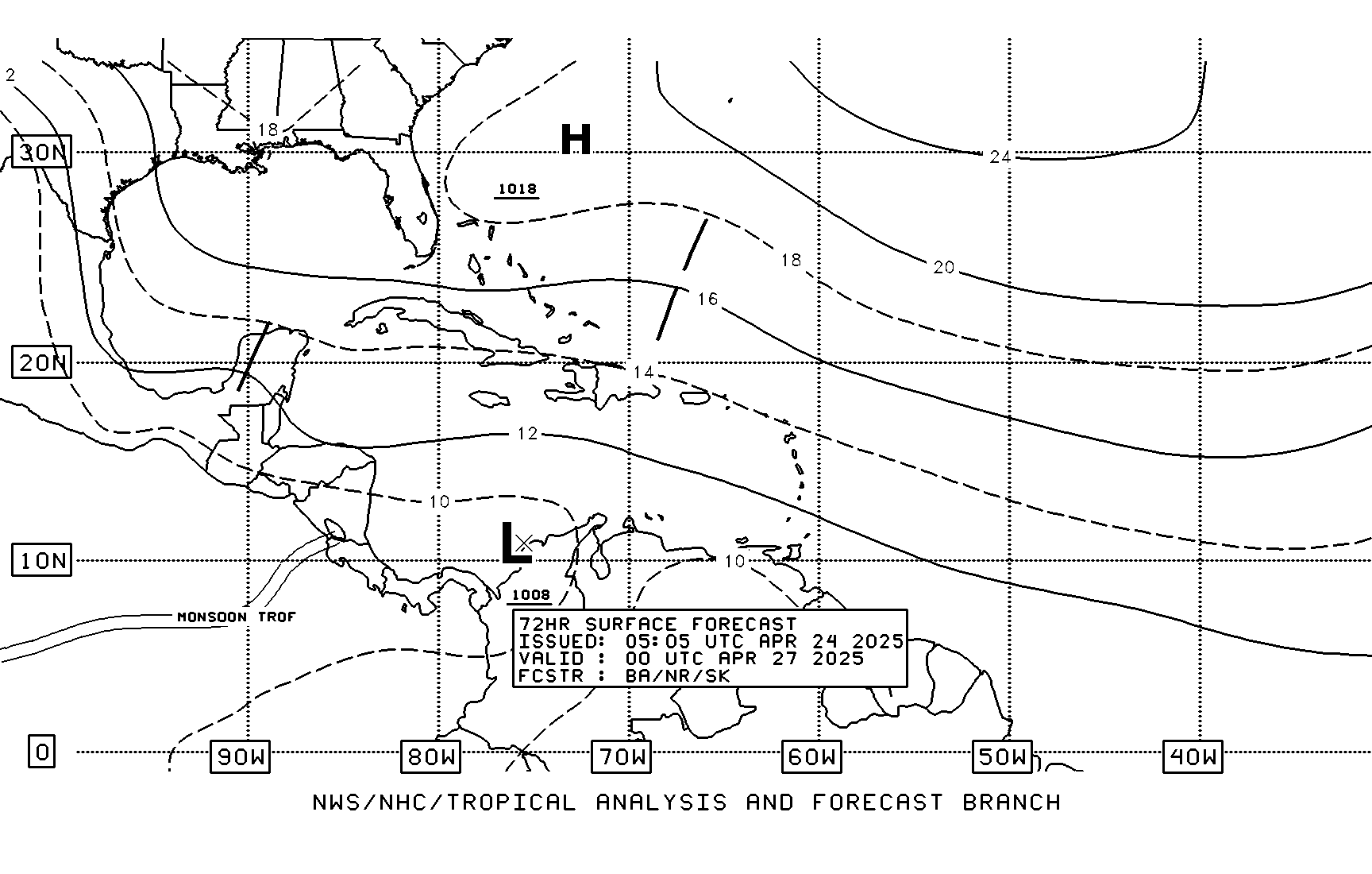
forecasting a weak low in the BOC for the 48 and 72 hr. time period.


0 likes
The following post is NOT an official forecast and should not be used as such. It is just the opinion of the poster and may or may not be backed by sound meteorological data. It is NOT endorsed by any professional institution including storm2k.org For Official Information please refer to the NHC and NWS products.
-
Dean4Storms
- S2K Supporter

- Posts: 6358
- Age: 63
- Joined: Sun Aug 31, 2003 1:01 pm
- Location: Miramar Bch. FL
Re: Gulf of Mexico
So today's 12z GFS run develops a Closed Low off the NW Yucatan peninsula over the weekend then heads toward South TX.
0 likes
-
Stormcenter
- S2K Supporter

- Posts: 6689
- Joined: Wed Sep 03, 2003 11:27 am
- Location: Houston, TX
Re: Gulf of Mexico
Link or image please...thanks.
Dean4Storms wrote:So today's 12z GFS run develops a Closed Low off the NW Yucatan peninsula over the weekend then heads toward South TX.
0 likes
-
hurrtracker79
- Tropical Depression

- Posts: 94
- Joined: Sun Jul 28, 2013 1:32 pm
Re: Gulf of Mexico
Stormcenter wrote:Link or image please...thanks.Dean4Storms wrote:So today's 12z GFS run develops a Closed Low off the NW Yucatan peninsula over the weekend then heads toward South TX.
12Z CMC and NAM also trying to develop a weak area of low pressure next week in the W Gulf. Awaiting the EURO..
0 likes
- gatorcane
- S2K Supporter

- Posts: 23708
- Age: 48
- Joined: Sun Mar 13, 2005 3:54 pm
- Location: Boca Raton, FL
Not sure if this is the right thread but NHC mentions it:
ZCZC MIATWOAT ALL
TTAA00 KNHC DDHHMM
TROPICAL WEATHER OUTLOOK
NWS NATIONAL HURRICANE CENTER MIAMI FL
200 PM EDT FRI JUN 12 2015
For the North Atlantic...Caribbean Sea and the Gulf of Mexico:
1. Disorganized showers and thunderstorms extending from the
northwestern Caribbean Sea to Belize and the Yucatan peninsula of
Mexico are primarily associated with an upper-level trough. This
activity is expected to move northwestward into the southwestern
Gulf of Mexico by late Sunday where development, if any, is unlikely
due to strong upper-level winds.
* Formation chance through 48 hours...low...near 0 percent
* Formation chance through 5 days...low...10 percent
Forecaster Blake/Franklin
0 likes
- PTrackerLA
- Category 5

- Posts: 5281
- Age: 42
- Joined: Thu Oct 10, 2002 8:40 pm
- Location: Lafayette, LA
Re: Gulf of Mexico
Interesting, looks like a big rain maker could be in the cards. Today is very "tropical" feeling with a repeating cycle of showers/sun/showers as the deep moisture flow from the Gulf is increasing.
0 likes
Re: Gulf of Mexico
Both GFS and NAM continue to show development off the NW coast of the Yucatan in 72 hours. Getting strong model support for a tropical storm in the GOM with CMC and Euro on board. Oh add the NAVGEM as on board too. Looks like upper Tx coast right now based on models.
0 likes
Re: Gulf of Mexico
Time for the fun and games to begin. We do not need anymore rain in SE TX after the heavy flooding rains last month. Several days of deep moisture from the Caribbean followed my a weak tropical system could bring a significant flood event. SE TX can stand 5-6" rains before flooding becomes an issue but with a tropical environment that could occur in several hours. Time to start watching the models a little closer.
0 likes
The following post is NOT an official forecast and should not be used as such. It is just the opinion of the poster and may or may not be backed by sound meteorological data. It is NOT endorsed by any professional institution including storm2k.org For Official Information please refer to the NHC and NWS products.
- cycloneye
- Admin

- Posts: 149742
- Age: 69
- Joined: Thu Oct 10, 2002 10:54 am
- Location: San Juan, Puerto Rico
Re: Gulf of Mexico
18z GFS is very bullish.


0 likes
Visit the Caribbean-Central America Weather Thread where you can find at first post web cams,radars
and observations from Caribbean basin members Click Here
and observations from Caribbean basin members Click Here
- Riptide
- Category 2

- Posts: 753
- Age: 34
- Joined: Fri Jul 23, 2010 3:33 pm
- Location: Cape May, New Jersey
- Contact:
Re:
gatorcane wrote:Because it shows a tropical storm
Didn't know Storm2k was the stock market. Joking
I'm kind of underwhelmed by the lack of coverage for this system. Typical GOM sleeper.
0 likes
Who is online
Users browsing this forum: Ulf and 206 guests


