Gulf of Mexico: Invest 91L is up

This is the general tropical discussion area. Anyone can take their shot at predicting a storms path.

Moderator: S2k Moderators

Forum rules

The posts in this forum are NOT official forecasts and should not be used as such. They are just the opinion of the poster and may or may not be backed by sound meteorological data. They are NOT endorsed by any professional institution or STORM2K. For official information, please refer to products from the National Hurricane Center and National Weather Service.

Help Support Storm2K
Message
Author
User avatar
ronjon
Category 5
Category 5
Posts: 4822
Joined: Fri Aug 19, 2005 5:17 pm
Location: Hernando Beach, FL

Re: Re:

#21 Postby ronjon » Fri Jun 12, 2015 6:15 pm

Riptide wrote:
gatorcane wrote:Because it shows a tropical storm

Didn't know Storm2k was the stock market. Joking ;)

I'm kind of underwhelmed by the lack of coverage for this system. Typical GOM sleeper.


Not sure the NHC has jumped on board yet. Probably waiting for a few more model cycles. When they start upping their odds, this board will get quite active.
0 likes   

User avatar
cycloneye
Admin
Admin
Posts: 145351
Age: 68
Joined: Thu Oct 10, 2002 10:54 am
Location: San Juan, Puerto Rico

Re: Re:

#22 Postby cycloneye » Fri Jun 12, 2015 6:23 pm

ronjon wrote:
Riptide wrote:
gatorcane wrote:Because it shows a tropical storm

Didn't know Storm2k was the stock market. Joking ;)

I'm kind of underwhelmed by the lack of coverage for this system. Typical GOM sleeper.


Not sure the NHC has jumped on board yet. Probably waiting for a few more model cycles. When they start upping their odds, this board will get quite active.


And board will go hopping when Invest is up.
0 likes   
Visit the Caribbean-Central America Weather Thread where you can find at first post web cams,radars
and observations from Caribbean basin members Click Here

User avatar
cycloneye
Admin
Admin
Posts: 145351
Age: 68
Joined: Thu Oct 10, 2002 10:54 am
Location: San Juan, Puerto Rico

Re: Gulf of Mexico

#23 Postby cycloneye » Fri Jun 12, 2015 6:41 pm

TROPICAL WEATHER OUTLOOK
NWS NATIONAL HURRICANE CENTER MIAMI FL
800 PM EDT FRI JUN 12 2015

For the North Atlantic...Caribbean Sea and the Gulf of Mexico:

Disorganized showers and thunderstorms extending from the
northwestern Caribbean Sea to Belize and the Yucatan peninsula of
Mexico are primarily associated with an upper-level trough. This
activity is expected to move northwestward into the southwestern
Gulf of Mexico by late Sunday. Development, if any, is expected to
be slow to occur due to marginal upper-level winds while this system
moves generally northwestward through the middle of next week.
* Formation chance through 48 hours...low...10 percent
* Formation chance through 5 days...low...20 percent

$$
Forecaster Brennan
0 likes   
Visit the Caribbean-Central America Weather Thread where you can find at first post web cams,radars
and observations from Caribbean basin members Click Here

CYCLONE MIKE
Category 5
Category 5
Posts: 2183
Joined: Tue Aug 31, 2004 6:04 pm
Location: Gonzales, LA

Re: Gulf of Mexico

#24 Postby CYCLONE MIKE » Fri Jun 12, 2015 7:32 pm

Im sure i know the answer but what is the euro making of this? A barely discernable sheared low?

Sure the cmc has it as at least a cat 4 by now :lol:
0 likes   

User avatar
gatorcane
S2K Supporter
S2K Supporter
Posts: 23691
Age: 47
Joined: Sun Mar 13, 2005 3:54 pm
Location: Boca Raton, FL

Re: Gulf of Mexico

#25 Postby gatorcane » Fri Jun 12, 2015 7:41 pm

CYCLONE MIKE wrote:Im sure i know the answer but what is the euro making of this? A barely discernable sheared low?

Sure the cmc has it as at least a cat 4 by now :lol:

ECMWF is showing some development and moves it into Southern Texas. 72 hours below. Interesting how the ECMWF suddenly became bullish even in it's short-term guidance:

Image
0 likes   

User avatar
gigabite
S2K Supporter
S2K Supporter
Posts: 916
Age: 72
Joined: Wed May 05, 2004 4:09 pm
Location: Naples, Florida

#26 Postby gigabite » Fri Jun 12, 2015 8:13 pm

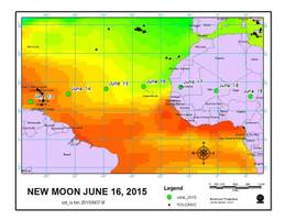
Image

The New Moon is going to be over this part of the world for the next few days. In the past there has been activity coincident with the pass.
0 likes   

User avatar
wxman57
Moderator-Pro Met
Moderator-Pro Met
Posts: 22979
Age: 67
Joined: Sat Jun 21, 2003 8:06 pm
Location: Houston, TX (southwest)

Re: Gulf of Mexico

#27 Postby wxman57 » Fri Jun 12, 2015 8:19 pm

I think there's a good chance a TD or weak TS will form before it moves inland on Tuesday. Regardless, the main threat will be more heavy rain for Texas and possibly Louisiana.
0 likes   

User avatar
Sambucol
Tropical Storm
Tropical Storm
Posts: 223
Joined: Wed Jul 25, 2007 5:09 pm

Re: Gulf of Mexico

#28 Postby Sambucol » Fri Jun 12, 2015 8:38 pm

wxman57 wrote:I think there's a good chance a TD or weak TS will form before it moves inland on Tuesday. Regardless, the main threat will be more heavy rain for Texas and possibly Louisiana.

Any power outages probable with this system or is it just flooding rains?
0 likes   

User avatar
Rgv20
S2K Supporter
S2K Supporter
Posts: 2466
Age: 38
Joined: Wed Jan 05, 2011 5:42 pm
Location: Edinburg/McAllen Tx

#29 Postby Rgv20 » Fri Jun 12, 2015 9:13 pm

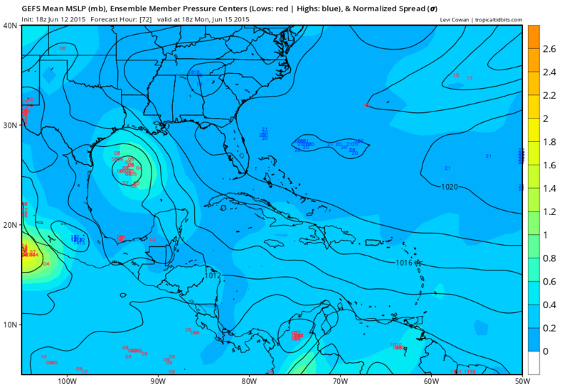
18zGFS Ensembles 3 days out....Consensus is for a weak low forming, could get interesting as get closer!
Image
0 likes   
The following post is NOT an official forecast and should not be used as such. It is just the opinion of the poster and may or may not be backed by sound meteorological data. It is NOT endorsed by any professional institution including storm2k.org For Official Information please refer to the NHC and NWS products.

TheStormExpert

Re: Gulf of Mexico

#30 Postby TheStormExpert » Fri Jun 12, 2015 9:42 pm

wxman57 wrote:I think there's a good chance a TD or weak TS will form before it moves inland on Tuesday. Regardless, the main threat will be more heavy rain for Texas and possibly Louisiana.

Not trying to sound absurd or anything, but if this was to develop I'd much rather see this go the additional 5mph to TS status than have a TD that when the season is all said and done never existed really. Something about those loner systems just drives me nuts! Probably the fact that named storms only get counted for.
0 likes   

User avatar
vbhoutex
Storm2k Executive
Storm2k Executive
Posts: 29112
Age: 73
Joined: Wed Oct 09, 2002 11:31 pm
Location: Cypress, TX
Contact:

Re: Gulf of Mexico

#31 Postby vbhoutex » Fri Jun 12, 2015 10:48 pm

KatDaddy wrote:Time for the fun and games to begin. We do not need anymore rain in SE TX after the heavy flooding rains last month. Several days of deep moisture from the Caribbean followed my a weak tropical system could bring a significant flood event. SE TX can stand 5-6" rains before flooding becomes an issue but with a tropical environment that could occur in several hours. Time to start watching the models a little closer.

Even the local OCM are jumping on board. This seems a little early for them considering nothing at all to look at right now. I'm hoping they don't hype too much, especially if nothing much happens, at least for our area. Of course it does help wake up the public to the threat, so there is a little of a good side to it too.
I know that the consensus that has developed has me watching much more closely.
0 likes   
Skywarn, C.E.R.T.
Please click below to donate to STORM2K to help with the expenses of keeping the site going:
Image

User avatar
Ntxw
Storm2k Moderator
Storm2k Moderator
Posts: 22786
Joined: Wed Oct 21, 2009 6:34 pm
Location: DFW, Texas

#32 Postby Ntxw » Fri Jun 12, 2015 10:52 pm

:uarrow: Yeah. Probably not something Texas wants to hear. Whether we get a named storm or not, the slug of moisture pairing Carlos' moisture on the other side will only aggravate the flooding potential.
0 likes   
The above post and any post by Ntxw is NOT an official forecast and should not be used as such. It is just the opinion of the poster and may or may not be backed by sound meteorological data. It is NOT endorsed by any professional institution including Storm2k. For official information, please refer to NWS products.

  Help support Storm2K!
Help Support Storm2K

Alyono
Professional-Met
Professional-Met
Posts: 6961
Joined: Fri Apr 26, 2013 3:52 pm
Location: Texas Coast

#33 Postby Alyono » Fri Jun 12, 2015 11:00 pm

0Z GFS still has it, albiet weaker. It sends it into Texas a bit sooner, late Monday or early Tuesday
0 likes   

Alyono
Professional-Met
Professional-Met
Posts: 6961
Joined: Fri Apr 26, 2013 3:52 pm
Location: Texas Coast

#34 Postby Alyono » Fri Jun 12, 2015 11:49 pm

Canadian model continues to trend weaker.

I think the 20 percent development chances are right on the money. 4 out of 5 of these systems will NOT develop based upon the expected environmental conditions, as well as the model trends.
0 likes   

CYCLONE MIKE
Category 5
Category 5
Posts: 2183
Joined: Tue Aug 31, 2004 6:04 pm
Location: Gonzales, LA

Re: Gulf of Mexico

#35 Postby CYCLONE MIKE » Sat Jun 13, 2015 5:32 am

Yep, looks like nothing of importance to track besides a deeper slug of moisture for Texas. Just another sheared mess that we have become accustomed to watching over the years that struggles to develop in the gulf. Might be lucky to get an invest out of this one.
0 likes   
This post is NOT AN OFFICIAL FORECAST and should not be used as such. It is just the opinion of the poster and may or may not be backed by sound meteorological data. It is NOT endorsed by any professional institution including storm2k.org. For Official Information please refer to the NHC and NWS products.

User avatar
cycloneye
Admin
Admin
Posts: 145351
Age: 68
Joined: Thu Oct 10, 2002 10:54 am
Location: San Juan, Puerto Rico

Re: Gulf of Mexico

#36 Postby cycloneye » Sat Jun 13, 2015 6:48 am

TROPICAL WEATHER OUTLOOK
NWS NATIONAL HURRICANE CENTER MIAMI FL
800 AM EDT SAT JUN 13 2015

For the North Atlantic...Caribbean Sea and the Gulf of Mexico:

Showers and thunderstorms have increased across the northwestern
Caribbean Sea and adjacent land areas in association with a trough
of low pressure that has recently formed at the surface. This system
is expected to move across the Yucatan peninsula later today and
into the southwestern Gulf of Mexico by late tomorrow. Environmental
conditions could support slow development of this system during the
next few days while it moves generally northwestward.
* Formation chance through 48 hours...low...20 percent
* Formation chance through 5 days...low...30 percent

$$
Forecaster Cangialosi/Blake
0 likes   
Visit the Caribbean-Central America Weather Thread where you can find at first post web cams,radars
and observations from Caribbean basin members Click Here

User avatar
cycloneye
Admin
Admin
Posts: 145351
Age: 68
Joined: Thu Oct 10, 2002 10:54 am
Location: San Juan, Puerto Rico

Re: Gulf of Mexico

#37 Postby cycloneye » Sat Jun 13, 2015 7:38 am

0 likes   
Visit the Caribbean-Central America Weather Thread where you can find at first post web cams,radars
and observations from Caribbean basin members Click Here


Return to “Talkin' Tropics”

Who is online

Users browsing this forum: Ulf and 52 guests