ATL: BILL - Post-Tropical

Moderator: S2k Moderators

Message
Author
User avatar
TeamPlayersBlue
Category 5
Category 5
Posts: 3445
Joined: Tue Feb 02, 2010 1:44 am
Location: Denver/Applewood, CO

Re:

#321 Postby TeamPlayersBlue » Mon Jun 15, 2015 2:18 pm

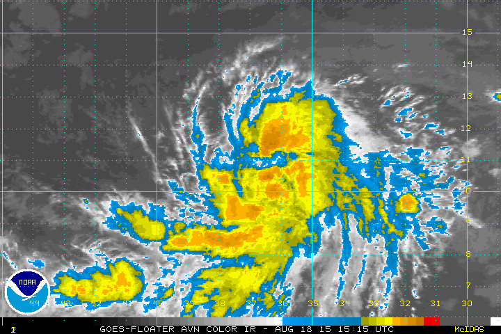
gatorcane wrote:Looks to be organizing to me looking at the latest loop plus seems to be growing in size (anticyclone is building right over top of it allowing the clouds to fan out more). Also looks to be gaining some latitude.

[img]http://i.imgur.com/s8kppQH.gi f[/img]


I mean i can visually see a circulation there lol, maybe its different in the lower levels
0 likes   
Personal Forecast Disclaimer:
The posts in this forum are NOT official forecast and should not be used as such. They are just the opinion of the poster and may or may not be backed by sound meteorological data. They are NOT endorsed by any professional institution or storm2k.org. For official information, please refer to the NHC and NWS products.

Nederlander
S2K Supporter
S2K Supporter
Posts: 1250
Joined: Sat Jul 19, 2008 4:28 pm
Location: Conroe, TX

Re:

#322 Postby Nederlander » Mon Jun 15, 2015 2:26 pm

Yellow Evan wrote:Where is the center?


Looks to be near 26N 93W
0 likes   

User avatar
Hammy
Category 5
Category 5
Posts: 5849
Age: 41
Joined: Fri May 25, 2012 5:25 pm
Contact:

Re: ATL: INVEST 91L - Discussion

#323 Postby Hammy » Mon Jun 15, 2015 2:31 pm

I see little to no change in organization from earlier, and the long loops can be a bit misleading. There appear to be two distinct areas of ration at the moment.
0 likes   
The above post is not official and should not be used as such. It is the opinion of the poster and may or may not be backed by sound meteorological data. It is not endorsed by any professional institution or storm2k.org. For official information, please refer to the NHC and NWS products.

User avatar
NDG
S2K Supporter
S2K Supporter
Posts: 15446
Joined: Sun Jul 09, 2006 10:14 pm
Location: Orlando, FL

Re: Re:

#324 Postby NDG » Mon Jun 15, 2015 2:34 pm

Nederlander wrote:
Yellow Evan wrote:Where is the center?


Looks to be near 26N 93W


I would place it more like 26.5N & 93W
Buoy 42002 (location of 26.1N & 93.7W) is still reporting NW winds even WNW winds for brief period of time.

Continuous Winds


TIME
(CDT)


1:50 pm NW ( 310 deg ) 12.6 kts
1:40 pm WNW ( 289 deg ) 12.0 kts
1:30 pm WNW ( 292 deg ) 11.1 kts
1:20 pm NW ( 309 deg ) 10.3 kts
1:10 pm NW ( 304 deg ) 11.3 kts
1:00 pm NW ( 311 deg ) 13.4 kts

http://www.ndbc.noaa.gov/station_page.php?station=42002
0 likes   

Nederlander
S2K Supporter
S2K Supporter
Posts: 1250
Joined: Sat Jul 19, 2008 4:28 pm
Location: Conroe, TX

Re: ATL: INVEST 91L - Discussion

#325 Postby Nederlander » Mon Jun 15, 2015 2:43 pm

Hammy wrote:I see little to no change in organization from earlier, and the long loops can be a bit misleading. There appear to be two distinct areas of ration at the moment.

I respectfully disagree based on imagery alone. We had the comma shape earlier and now it's getting more of a pinwheel shape to it as clouds fan out. I also don't see the two areas you are referring to.
0 likes   

User avatar
NDG
S2K Supporter
S2K Supporter
Posts: 15446
Joined: Sun Jul 09, 2006 10:14 pm
Location: Orlando, FL

#326 Postby NDG » Mon Jun 15, 2015 2:46 pm

Conditions on one of the oil platforms, rocking and rolling several hundred feet above the surface.

Conditions at: KVQT (VERMILION 331 , LA, US) observed 1935 UTC 15 June 2015
Temperature: 25.0°C (77°F)
Dewpoint: 24.0°C (75°F) [RH = 94%]
Pressure (altimeter): 29.89 inches Hg (1012.3 mb)
Winds: from the SSE (160 degrees) at 38 MPH (33 knots; 17.2 m/s)
gusting to 51 MPH (44 knots; 22.9 m/s)

Visibility: 1.25 miles (2.01 km)
Ceiling: 2800 feet AGL
Clouds: scattered clouds at 1200 feet AGL
broken clouds at 2800 feet AGL
broken clouds at 4500 feet AGL
Weather: BR (mist)
0 likes   

User avatar
TropicalAnalystwx13
Category 5
Category 5
Posts: 2109
Age: 27
Joined: Tue Jul 19, 2011 8:20 pm
Location: Wilmington, NC
Contact:

#327 Postby TropicalAnalystwx13 » Mon Jun 15, 2015 2:46 pm

The beginning of a central dense overcast?

Image
0 likes   

User avatar
Hammy
Category 5
Category 5
Posts: 5849
Age: 41
Joined: Fri May 25, 2012 5:25 pm
Contact:

Re: ATL: INVEST 91L - Discussion

#328 Postby Hammy » Mon Jun 15, 2015 2:51 pm

Nederlander wrote:
Hammy wrote:I see little to no change in organization from earlier, and the long loops can be a bit misleading. There appear to be two distinct areas of ration at the moment.

I respectfully disagree based on imagery alone. We had the comma shape earlier and now it's getting more of a pinwheel shape to it as clouds fan out. I also don't see the two areas you are referring to.


http://www.ssd.noaa.gov/PS/TROP/floaters/91L/flash-rgb-long.html

27/93.5 as evidenced by earlier low cloud movement and continued eastward expansion of convection, and 25.5/92, as evidenced by low cloud movement and spiral formation. IR can be very deceiving on less organized systems. While I think it should've been upgraded hours ago, if they are waiting for better organization than we saw earlier, it looks highly unlikely it will be named.
0 likes   
The above post is not official and should not be used as such. It is the opinion of the poster and may or may not be backed by sound meteorological data. It is not endorsed by any professional institution or storm2k.org. For official information, please refer to the NHC and NWS products.

User avatar
tropicwatch
Category 5
Category 5
Posts: 3383
Age: 61
Joined: Sat Jun 02, 2007 10:01 am
Location: Panama City Florida
Contact:

#329 Postby tropicwatch » Mon Jun 15, 2015 2:53 pm

Showers building near suspect LLC.

Image
0 likes   
Tropicwatch


Agnes 72', Eloise 75, Elena 85', Kate 85', Charley 86', Florence 88', Beryl 94', Dean 95', Erin 95', Opal 95', Earl 98', Georges 98', Ivan 2004', Arlene 2005', Dennis 2005', Ida 2009' Debby 2012' Irma 2017' Michael 2018'

wicked_wx_watcher
Tropical Depression
Tropical Depression
Posts: 53
Joined: Sat Jan 13, 2007 12:56 pm
Location: Clear Lake City/Webster, TX

#330 Postby wicked_wx_watcher » Mon Jun 15, 2015 2:53 pm

At least local authorities are being a little proactive. Galveston County has called for a voluntary evacuation of the Bolivar Peninsula. There are only two ways to leave the peninsula. Hwy 124 and 87 to High Island floods very easily. The other way is by ferry and those will shut down as Galveston Bay gets rough.
0 likes   

User avatar
Houstonia
S2K Supporter
S2K Supporter
Posts: 829
Age: 60
Joined: Fri Oct 11, 2002 9:45 am
Location: Sharpstown, Houston, Harris County, Southeast Texas.

Re: ATL: INVEST 91L - Discussion

#331 Postby Houstonia » Mon Jun 15, 2015 2:59 pm

Texas gov. Has activated the state operations center.

Sorry - brief. In meeting and just got the email.
0 likes   

User avatar
Steve
S2K Supporter
S2K Supporter
Posts: 9621
Joined: Sat Apr 05, 2003 11:41 pm
Location: Not a state-caster

#332 Postby Steve » Mon Jun 15, 2015 3:00 pm

Breezy with spotty rain moving in out the SE here.
0 likes   

User avatar
TropicalAnalystwx13
Category 5
Category 5
Posts: 2109
Age: 27
Joined: Tue Jul 19, 2011 8:20 pm
Location: Wilmington, NC
Contact:

#333 Postby TropicalAnalystwx13 » Mon Jun 15, 2015 3:02 pm

It's not hard at all to see that 91L has become much better organized since this morning. The next recon flight should be in the storm around 0z--we'll see how much it has changed.
0 likes   

Nederlander
S2K Supporter
S2K Supporter
Posts: 1250
Joined: Sat Jul 19, 2008 4:28 pm
Location: Conroe, TX

Re:

#334 Postby Nederlander » Mon Jun 15, 2015 3:03 pm

wicked_wx_watcher wrote:At least local authorities are being a little proactive. Galveston County has called for a voluntary evacuation of the Bolivar Peninsula. There are only two ways to leave the peninsula. Hwy 124 and 87 to High Island floods very easily. The other way is by ferry and those will shut down as Galveston Bay gets rough.


Nothing official on the Bolivar Ferry yet. Typically will run until winds reach 50mph or 4.5" above normal tide. Depending on landfall, both of those numbers are in the possible range. But it's better to get out than be trapped like a lot were during Ike. (No I'm not comparing this to Ike lol. But Ike showed us how quickly Bolivar can be cut off and essentially become an island.)
0 likes   

emeraldislenc
Category 2
Category 2
Posts: 559
Joined: Fri Aug 24, 2012 4:49 pm
Location: Emerald Isle NC

Re: ATL: INVEST 91L - Discussion

#335 Postby emeraldislenc » Mon Jun 15, 2015 3:09 pm

It is looking more and more like a storm.? What are the thoughts about upgrading at 5? :flag:
0 likes   

User avatar
Portastorm
Storm2k Moderator
Storm2k Moderator
Posts: 9914
Age: 63
Joined: Fri Jul 11, 2003 9:16 am
Location: Round Rock, TX
Contact:

Re: ATL: INVEST 91L - Discussion

#336 Postby Portastorm » Mon Jun 15, 2015 3:11 pm

No "Bill" yet. NHC just tweeted that no advisories will be issued at 5 p.m. Eastern. Next plane in system at 8 p.m.
0 likes   
Any forecasts under my name are to be taken with a grain of salt. Get your best forecasts from the National Weather Service and National Hurricane Center.

User avatar
tailgater
S2K Supporter
S2K Supporter
Posts: 3339
Joined: Sun Jul 11, 2004 9:13 pm
Location: St. Amant La.

Re: ATL: INVEST 91L - Discussion

#337 Postby tailgater » Mon Jun 15, 2015 3:11 pm

Looking at the high res satellite loop, the loose center seems to be very near that new hot tower about 30 miles to SE.

Image
0 likes   
The following post is NOT an official forecast and should not be used as such. It is just the opinion of the poster and may or may not be backed by sound meteorological data. It is NOT endorsed by any professional institution including storm2k.org For Official Information please refer to the NHC and NWS products.

User avatar
ScottNAtlanta
Category 5
Category 5
Posts: 2367
Joined: Sat May 25, 2013 3:11 pm
Location: Atlanta, GA

#338 Postby ScottNAtlanta » Mon Jun 15, 2015 3:11 pm

No upgrade at 5p per NHC aircraft will be there at 8p
0 likes   
The posts in this forum are NOT official forecast and should not be used as such. They are just the opinion of the poster and may or may not be backed by sound meteorological data. They are NOT endorsed by any professional institution or storm2k.org. For official information, please refer to the NHC and NWS products.

wicked_wx_watcher
Tropical Depression
Tropical Depression
Posts: 53
Joined: Sat Jan 13, 2007 12:56 pm
Location: Clear Lake City/Webster, TX

Re: Re:

#339 Postby wicked_wx_watcher » Mon Jun 15, 2015 3:13 pm

Nederlander wrote:
wicked_wx_watcher wrote:At least local authorities are being a little proactive. Galveston County has called for a voluntary evacuation of the Bolivar Peninsula. There are only two ways to leave the peninsula. Hwy 124 and 87 to High Island floods very easily. The other way is by ferry and those will shut down as Galveston Bay gets rough.


Nothing official on the Bolivar Ferry yet. Typically will run until winds reach 50mph or 4.5" above normal tide. Depending on landfall, both of those numbers are in the possible range. But it's better to get out than be trapped like a lot were during Ike. (No I'm not comparing this to Ike lol. But Ike showed us how quickly Bolivar can be cut off and essentially become an island.)


You are absolutely right! It's so flat there, that it can take a couple of days for the water to recede and roads to become passable again. I'm not really worried about the houses. New building requirements put them well above flooding risk. I worry about damage to the dunes.
0 likes   

User avatar
northjaxpro
S2K Supporter
S2K Supporter
Posts: 8900
Joined: Mon Sep 27, 2010 11:21 am
Location: Jacksonville, FL

#340 Postby northjaxpro » Mon Jun 15, 2015 3:14 pm

NHC is simply waiting for Recon to confirm before upgrading when they get in there early this evening. I will say it is definitely better organized than when I last checked in earlier today around 12Z this morning.
0 likes   
NEVER, EVER SAY NEVER in the tropics and weather in general, and most importantly, with life itself!!

________________________________________________________________________________________

Fay 2008 Beryl 2012 Debby 2012 Colin 2016 Hermine 2016 Julia 2016 Matthew 2016 Irma 2017 Dorian 2019


Return to “2015”

Who is online

Users browsing this forum: No registered users and 3 guests