ATL: BILL - Post-Tropical

Moderator: S2k Moderators

Message
Author
ozonepete
Professional-Met
Professional-Met
Posts: 4743
Joined: Mon Sep 07, 2009 3:23 pm
Location: From Ozone Park, NYC / Now in Brooklyn, NY

Re: Re:

#401 Postby ozonepete » Mon Jun 15, 2015 4:15 pm

Alyono wrote:
davidiowx wrote:
wkwally wrote:I can understand the NHC not pulling the trigger and nameing this system but at the very least they should be issuing watchs. But once more and as I said before I hope thay are seeing something I am not.


My thoughts exactly. I am quite surprised watches have no been issued yet. Perhaps they see something nobody else does....


their procedures do not allow them to issue warnings before an advisory is issued. Typical government over here it seems. Best to follow hard and fast procedures that take too long to change.


IMHO they do a really great job. No one does it better on the scale they do. No one.
0 likes   

SeGaBob

#402 Postby SeGaBob » Mon Jun 15, 2015 4:16 pm

The ridge that's steering this into Texas is also roasting the Southeast U.S. (myself included) We're supposed to hit 100 here tomorrow. :onfire:
Last edited by SeGaBob on Mon Jun 15, 2015 4:17 pm, edited 1 time in total.
0 likes   

User avatar
gatorcane
S2K Supporter
S2K Supporter
Posts: 23691
Age: 47
Joined: Sun Mar 13, 2005 3:54 pm
Location: Boca Raton, FL

#403 Postby gatorcane » Mon Jun 15, 2015 4:16 pm

I would be shocked if this does not get upgraded at some point this evening. I see they are flying another plane out there.

By the way assuming it gets upgraded we would have had two storms already this season. My guess is that we would be tracking above average for the Atlantic, not bad considering most predicted a slow season.
Last edited by gatorcane on Mon Jun 15, 2015 4:19 pm, edited 2 times in total.
0 likes   

User avatar
NDG
S2K Supporter
S2K Supporter
Posts: 15446
Joined: Sun Jul 09, 2006 10:14 pm
Location: Orlando, FL

#404 Postby NDG » Mon Jun 15, 2015 4:18 pm

This is the best looking Invest I have ever seen ;)

Image
0 likes   

User avatar
Houstonia
S2K Supporter
S2K Supporter
Posts: 829
Age: 60
Joined: Fri Oct 11, 2002 9:45 am
Location: Sharpstown, Houston, Harris County, Southeast Texas.

Re:

#405 Postby Houstonia » Mon Jun 15, 2015 4:19 pm

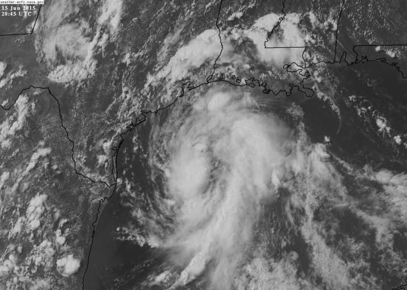
I agree. The stores in Houston already (according to twitter reports) have lines around the stores and are running out or low on water and canned goods. People DO need to be careful, but this is a low end tropical storm and the concern should be centered around the FLOODING potential as opposed to massive power outages, and wind damage that a cat 1-3 hurricane would bring in. So, I agree with the NHC holding off. What a surprise - maybe some of us will actually have to GO TO WORK tomorrow and OMG drive in a pouring rain!! Sorry - I'm a bit sarcastic, because in the past - when I was growing up in Houston, people worked during tropical storms - Nowadays it seems that people expect for the city to stop running as a result of one.

/grumpiness off.

Editing to reiterate: the FLOODING potential is what should be stressed and where the concern should be placed. IMHO, of course.

collegebroke wrote:As a Houston resident thinking back to Rita, people spent hours/days in the car trying to get out of town. Even though things have been improved, I can see why the NHC is hesitant to put out an advisory because it may cause people to get out into the danger when they will probably ride this one out if they stay at home. The flooding week before last was bad in some areas. It was not a named storm and we still lost 12 souls to the waters. People around here are nervous because the lakes, rivers, and bayous haven't receded yet. I'm sure the NHC knows this because every OEM around here has probably told them. If I was the guy responsible for signing that forecast and posting it, I'd make sure I had some really good info in my pocket before I started asking all these communities to go into major event protocol. It could cost more lives by calling it (especially at rush hour) rather than not around here. IMHO. Thanks
Last edited by Houstonia on Mon Jun 15, 2015 4:22 pm, edited 1 time in total.
0 likes   

User avatar
NDG
S2K Supporter
S2K Supporter
Posts: 15446
Joined: Sun Jul 09, 2006 10:14 pm
Location: Orlando, FL

Re:

#406 Postby NDG » Mon Jun 15, 2015 4:19 pm

SeGaBob wrote:The ridge that's steering this into Texas is also roasting the Southeast U.S. (myself included) We're supposed to hit 100 here tomorrow. :onfire:


The Bermuda ridge is back this year :)
0 likes   

davidiowx
Category 1
Category 1
Posts: 390
Joined: Tue Sep 10, 2013 11:07 am
Location: Richmond, TX

Re: Re:

#407 Postby davidiowx » Mon Jun 15, 2015 4:19 pm

psyclone wrote:Not according to this poster. Says it happens all the time although I'm still awaiting any one example. I believe you are correct...No advisory=no watches/warnings.


I said in the Atlantic islands. And what Blinhart said actually makes sense. That is likely why they issue them out there for storms that aren't classified yet. As they do it often.
0 likes   

User avatar
Houstonia
S2K Supporter
S2K Supporter
Posts: 829
Age: 60
Joined: Fri Oct 11, 2002 9:45 am
Location: Sharpstown, Houston, Harris County, Southeast Texas.

Re: ATL: INVEST 91L - Discussion

#408 Postby Houstonia » Mon Jun 15, 2015 4:21 pm

Just received this email locally in Houston - someone has already upgraded the system on their own, it seems...

Midwest Storefront, Houston Police AGENCY
Let's hope that everyone can remain somewhere safe as Houston is about to be hit by tropical storm Bill. If assistance is needed, FEMA will be available:
FEMA Disaster Recovery Center
Leonel Castillo Community Center
2101 South St.
Houston TX 77009
Daily hours of operation:
Monday-Friday 9am – 8pm
Saturday 9am – 2pm
Sunday Closed
0 likes   

HurriGuy
S2K Supporter
S2K Supporter
Posts: 734
Joined: Thu Aug 15, 2013 8:43 pm
Location: Prairieville, LA

#409 Postby HurriGuy » Mon Jun 15, 2015 4:22 pm

Last storm I can think of in this location was Tropical Storm Karen, and I think we all remember what a joke that was. But they won't name this "invest".
0 likes   
The posts in this forum are NOT official forecast and should not be used as such. They are just the opinion of the poster and may or may not be backed by sound meteorological data. They are NOT endorsed by any professional institution or storm2k.org. For official information, please refer to the NHC and NWS products.

psyclone
S2K Supporter
S2K Supporter
Posts: 4762
Joined: Wed Aug 24, 2005 9:04 pm
Location: palm harbor fl

Re: Re:

#410 Postby psyclone » Mon Jun 15, 2015 4:23 pm

Blinhart wrote:If I remember correctly the islands of the Caribbean can issue watches and warnings because they are under their own government rules and can issue watches and warnings with out having to have authorization from the NHC. I could be wrong, but I think in the past the islands have issued watches when they think a wave will be a system by the time it reaches them.

The first part is definitely correct hence the wording "the government of ________ has issued _______...but I didn't know any of them issued watches/warnings pre cyclone designation. I do recall the French gov having a much shorter fuse on a hurricane warning in the past (like 6 or 12 hours) which could have resulted in some confusion but I don't know if that's still the case. I do believe in watch/warning issuance pre designation if formation is highly likely and the system is nearing the coast (as in this case) I just never knew it to be done...by the US or any other gov in the Atlantic basin.
0 likes   

User avatar
Portastorm
Storm2k Moderator
Storm2k Moderator
Posts: 9914
Age: 63
Joined: Fri Jul 11, 2003 9:16 am
Location: Round Rock, TX
Contact:

Re: ATL: INVEST 91L - Discussion

#411 Postby Portastorm » Mon Jun 15, 2015 4:23 pm

Houstonia wrote:Just received this email locally in Houston - someone has already upgraded the system on their own, it seems...

Midwest Storefront, Houston Police AGENCY
Let's hope that everyone can remain somewhere safe as Houston is about to be hit by tropical storm Bill. If assistance is needed, FEMA will be available:
FEMA Disaster Recovery Center
Leonel Castillo Community Center
2101 South St.
Houston TX 77009
Daily hours of operation:
Monday-Friday 9am – 8pm
Saturday 9am – 2pm
Sunday Closed


The center has actually been opened as a result of serving persons impacted by the flooding which has occurred over the last few weeks. The opening of this disaster recovery center has nothing to do with the current "91L-proto Bill" situation.
0 likes   
Any forecasts under my name are to be taken with a grain of salt. Get your best forecasts from the National Weather Service and National Hurricane Center.

User avatar
Nimbus
Category 5
Category 5
Posts: 5300
Joined: Mon Jul 19, 2004 10:54 am

Re: ATL: INVEST 91L - Discussion

#412 Postby Nimbus » Mon Jun 15, 2015 4:23 pm

Except for the burst of convection near the center the storm presents as a very dry system.
At the time of the last recon there was even an outflow boundary south of Louisiana.
The outflow subsidence from Carlos is relatively dry,the moisture condensed out at high altitude.


91l seems to be moving pretty fast, by the time the next recon mission completes the NHC might be able to narrow down the forecast areas that they expect to be affected.
0 likes   

User avatar
NDG
S2K Supporter
S2K Supporter
Posts: 15446
Joined: Sun Jul 09, 2006 10:14 pm
Location: Orlando, FL

#413 Postby NDG » Mon Jun 15, 2015 4:24 pm

Another look at SSTs, temps get near 30 deg C by coast of TX.

Image
0 likes   

User avatar
cycloneye
Admin
Admin
Posts: 145306
Age: 68
Joined: Thu Oct 10, 2002 10:54 am
Location: San Juan, Puerto Rico

Re: ATL: INVEST 91L - Discussion

#414 Postby cycloneye » Mon Jun 15, 2015 4:27 pm

Plane has left Keesler base.
0 likes   
Visit the Caribbean-Central America Weather Thread where you can find at first post web cams,radars
and observations from Caribbean basin members Click Here

User avatar
Portastorm
Storm2k Moderator
Storm2k Moderator
Posts: 9914
Age: 63
Joined: Fri Jul 11, 2003 9:16 am
Location: Round Rock, TX
Contact:

Re: ATL: INVEST 91L - Discussion

#415 Postby Portastorm » Mon Jun 15, 2015 4:29 pm

Nimbus wrote:Except for the burst of convection near the center the storm presents as a very dry system.
At the time of the last recon there was even an outflow boundary south of Louisiana.
The outflow subsidence from Carlos is relatively dry,the moisture condensed out at high altitude.


91l seems to be moving pretty fast, by the time the next recon mission completes the NHC might be able to narrow down the forecast areas that they expect to be affected.


By "dry" I assume you mean a lack of extensive convection? You must because in terms of PWs and water vapor, this thing has a very large envelope and is very wet ... which is one reason why the inland rainfall totals predicted by most models are so high across east Texas.
0 likes   
Any forecasts under my name are to be taken with a grain of salt. Get your best forecasts from the National Weather Service and National Hurricane Center.

User avatar
Houstonia
S2K Supporter
S2K Supporter
Posts: 829
Age: 60
Joined: Fri Oct 11, 2002 9:45 am
Location: Sharpstown, Houston, Harris County, Southeast Texas.

Re: ATL: INVEST 91L - Discussion

#416 Postby Houstonia » Mon Jun 15, 2015 4:30 pm

I meant because they refer to the system as "Tropical Storm Bill". :-)

Portastorm wrote:
Houstonia wrote:Just received this email locally in Houston - someone has already upgraded the system on their own, it seems...

Midwest Storefront, Houston Police AGENCY
Let's hope that everyone can remain somewhere safe as Houston is about to be hit by tropical storm Bill. If assistance is needed, FEMA will be available:
FEMA Disaster Recovery Center
Leonel Castillo Community Center
2101 South St.
Houston TX 77009
Daily hours of operation:
Monday-Friday 9am – 8pm
Saturday 9am – 2pm
Sunday Closed


The center has actually been opened as a result of serving persons impacted by the flooding which has occurred over the last few weeks. The opening of this disaster recovery center has nothing to do with the current "91L-proto Bill" situation.
0 likes   

User avatar
Portastorm
Storm2k Moderator
Storm2k Moderator
Posts: 9914
Age: 63
Joined: Fri Jul 11, 2003 9:16 am
Location: Round Rock, TX
Contact:

Re: ATL: INVEST 91L - Discussion

#417 Postby Portastorm » Mon Jun 15, 2015 4:33 pm

:uarrow:

Oh I know what you meant ... :wink: ... I wanted to clarify for folks though who may have thought FEMA was pre-emptively opening a disaster recovery center. Besides, "91L" just doesn't have the ring to it that "Bill" does. LOL.
0 likes   
Any forecasts under my name are to be taken with a grain of salt. Get your best forecasts from the National Weather Service and National Hurricane Center.

User avatar
Houstonia
S2K Supporter
S2K Supporter
Posts: 829
Age: 60
Joined: Fri Oct 11, 2002 9:45 am
Location: Sharpstown, Houston, Harris County, Southeast Texas.

Re: ATL: INVEST 91L - Discussion

#418 Postby Houstonia » Mon Jun 15, 2015 4:34 pm

Cool... gotcha. :)

Portastorm wrote::uarrow:

Oh I know what you meant ... :wink: ... I wanted to clarify for folks though who may have thought FEMA was pre-emptively opening a disaster recovery center. Besides, "91L" just doesn't have the ring to it that "Bill" does. LOL.
0 likes   

User avatar
MGC
S2K Supporter
S2K Supporter
Posts: 5899
Joined: Sun Mar 23, 2003 9:05 pm
Location: Pass Christian MS, or what is left.

Re: ATL: INVEST 91L - Discussion

#419 Postby MGC » Mon Jun 15, 2015 4:36 pm

NHC will initiate advisories when there is a known TC. Currently all we have is a good looking MLC, who know what is going on at the surface. Odds are IMO that 91L will get upgraded soon.....MGC
0 likes   

User avatar
wkwally
Category 1
Category 1
Posts: 279
Joined: Sun Jun 27, 2010 9:18 pm
Location: Humble, Texas

Re: ATL: INVEST 91L - Discussion

#420 Postby wkwally » Mon Jun 15, 2015 4:40 pm

MGC wrote:NHC will initiate advisories when there is a known TC. Currently all we have is a good looking MLC, who know what is going on at the surface. Odds are IMO that 91L will get upgraded soon.....MGC

I am sure you are right as with each one of these I learn something new
0 likes   


Return to “2015”

Who is online

Users browsing this forum: No registered users and 7 guests