Tropical Wave in the Eastern Caribbean

This is the general tropical discussion area. Anyone can take their shot at predicting a storms path.

Moderator: S2k Moderators

Forum rules

The posts in this forum are NOT official forecasts and should not be used as such. They are just the opinion of the poster and may or may not be backed by sound meteorological data. They are NOT endorsed by any professional institution or STORM2K. For official information, please refer to products from the National Hurricane Center and National Weather Service.

Help Support Storm2K
Message
Author
User avatar
gatorcane
S2K Supporter
S2K Supporter
Posts: 23691
Age: 47
Joined: Sun Mar 13, 2005 3:54 pm
Location: Boca Raton, FL

Tropical Wave in the Eastern Caribbean

#1 Postby gatorcane » Thu Jun 18, 2015 2:15 pm

Kindaof an intriguing area in the South-Central Atlantic with the ECMWF and GEM models trying to close off a low from this area in the next 72 hours

Has some nice spin. Obviously it has a lot of things stacked against it for development given climatology, the shear zone out ahead of it, and the lack of any big thunderstorm development. SAL and shear should keep this in check.

You can see the area here in this SAT image heading west:
Image
Last edited by gatorcane on Tue Jun 23, 2015 7:50 am, edited 7 times in total.
0 likes   

User avatar
northjaxpro
S2K Supporter
S2K Supporter
Posts: 8900
Joined: Mon Sep 27, 2010 11:21 am
Location: Jacksonville, FL

#2 Postby northjaxpro » Thu Jun 18, 2015 2:20 pm

SAL and shear will probably keep this from developing down the road. I will start paying more attention out there in that part of the Tropical Atlantic come late July into August.
0 likes   
NEVER, EVER SAY NEVER in the tropics and weather in general, and most importantly, with life itself!!

________________________________________________________________________________________

Fay 2008 Beryl 2012 Debby 2012 Colin 2016 Hermine 2016 Julia 2016 Matthew 2016 Irma 2017 Dorian 2019

User avatar
tropicwatch
Category 5
Category 5
Posts: 3386
Age: 61
Joined: Sat Jun 02, 2007 10:01 am
Location: Panama City Florida
Contact:

#3 Postby tropicwatch » Thu Jun 18, 2015 2:24 pm

SAL is pretty tough right now all the way to the Caribbean.
Image
0 likes   
Tropicwatch


Agnes 72', Eloise 75, Elena 85', Kate 85', Charley 86', Florence 88', Beryl 94', Dean 95', Erin 95', Opal 95', Earl 98', Georges 98', Ivan 2004', Arlene 2005', Dennis 2005', Ida 2009' Debby 2012' Irma 2017' Michael 2018'

User avatar
Nimbus
Category 5
Category 5
Posts: 5301
Joined: Mon Jul 19, 2004 10:54 am

Re: Area of Disturbed Weather in the South-Central Atlantic

#4 Postby Nimbus » Thu Jun 18, 2015 2:26 pm

This is a classic wave moving west dry air diving down in front of it.
Time to update my Central Atlantic loop to flash player.
0 likes   

User avatar
cycloneye
Admin
Admin
Posts: 145344
Age: 68
Joined: Thu Oct 10, 2002 10:54 am
Location: San Juan, Puerto Rico

Re: Area of Disturbed Weather in the South-Central Atlantic

#5 Postby cycloneye » Thu Jun 18, 2015 2:37 pm

Hopefully,this wave brings some needed rain to Puerto Rico and many of the islands that are going thru a drought right now.

ALTHOUGH TUTT PATTERN IS TO ESTABLISH ACROSS THE FORECAST AREA THE
BEST AVAILABLE MOISTURE IS EXPECTED TO REACH THE FORECAST AREA ON
MONDAY WHEN A TROPICAL WAVE IS EXPECTED TO ENTER THE EASTERN
CARIBBEAN AND THE TUTT IS TO THE NORTH OF THE HISPANIOLA.
0 likes   
Visit the Caribbean-Central America Weather Thread where you can find at first post web cams,radars
and observations from Caribbean basin members Click Here

User avatar
wxman57
Moderator-Pro Met
Moderator-Pro Met
Posts: 22979
Age: 67
Joined: Sat Jun 21, 2003 8:06 pm
Location: Houston, TX (southwest)

Re: Area of Disturbed Weather in the South-Central Atlantic

#6 Postby wxman57 » Thu Jun 18, 2015 3:33 pm

I don't hold out much hope for rain in PR, cycloneye. This wave will probably traverse the Caribbean with little or no convection. I'm afraid that the Euro is predicting even drier conditions there than last year.
0 likes   

User avatar
gatorcane
S2K Supporter
S2K Supporter
Posts: 23691
Age: 47
Joined: Sun Mar 13, 2005 3:54 pm
Location: Boca Raton, FL

#7 Postby gatorcane » Thu Jun 18, 2015 8:56 pm

Nice flare up of storms this evening. Latest GFS run sends this through Puerto Rico and Bahamas after that. Hopefully it makes it to Florida to bring us some much needed rainfall.
0 likes   

User avatar
Hurricaneman
Category 5
Category 5
Posts: 7351
Age: 45
Joined: Tue Aug 31, 2004 3:24 pm
Location: central florida

Re: Area of Disturbed Weather in the South-Central Atlantic

#8 Postby Hurricaneman » Thu Jun 18, 2015 9:57 pm

May need to be watched if and only if it can get north of the islands as theres quite a bit of shear in the MDR

The posts in this forum are NOT official forecast and should not be used as such. They are just the opinion of the poster and may or may not be backed by sound meteorological data. They are NOT endorsed by any professional institution or storm2k.org. For official information, please refer to the NHC and NWS products
0 likes   

floridasun78
Category 5
Category 5
Posts: 3755
Joined: Sun May 17, 2009 10:16 pm
Location: miami fl

Re: Area of Disturbed Weather in the South-Central Atlantic

#9 Postby floridasun78 » Thu Jun 18, 2015 10:46 pm

Image this close up area
0 likes   

User avatar
gatorcane
S2K Supporter
S2K Supporter
Posts: 23691
Age: 47
Joined: Sun Mar 13, 2005 3:54 pm
Location: Boca Raton, FL

#10 Postby gatorcane » Fri Jun 19, 2015 9:22 am

Nice looking wave with convection on the increase and spin very evident. Guidance continues to bring this vigorous wave through the NE Leewards, Puerto Rico and possibly Bahamas after that. Hopefully it will bring some rain to these areas and still hoping it reaches Southern Florida as it would definitely bring some much needed rainfall.

Image
0 likes   

User avatar
northjaxpro
S2K Supporter
S2K Supporter
Posts: 8900
Joined: Mon Sep 27, 2010 11:21 am
Location: Jacksonville, FL

#11 Postby northjaxpro » Fri Jun 19, 2015 9:30 am

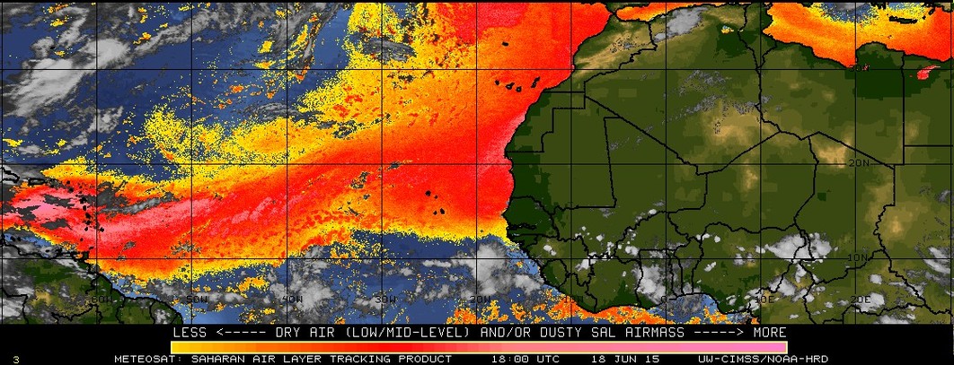
This morning I have to say that this is the best this wave as looked on satellite thus far. The wave is holding together somewhat for now, but it is fighting against the SAL and eventual shear once it approaches the NE Caribbean. I still don't anticipate development, but the wave may hold together enough to bring rain to the NE Caribbean Islands the next few days.
0 likes   
NEVER, EVER SAY NEVER in the tropics and weather in general, and most importantly, with life itself!!

________________________________________________________________________________________

Fay 2008 Beryl 2012 Debby 2012 Colin 2016 Hermine 2016 Julia 2016 Matthew 2016 Irma 2017 Dorian 2019

User avatar
gatorcane
S2K Supporter
S2K Supporter
Posts: 23691
Age: 47
Joined: Sun Mar 13, 2005 3:54 pm
Location: Boca Raton, FL

#12 Postby gatorcane » Fri Jun 19, 2015 9:35 am

It's interesting to note the global models are actually decreasing the shear some in the area just east of the Leewards in the MDR by days 4 and 5 while keeping strong shear across the Caribbean Sea. Shear north of the Caribbean doesn't look that bad. For example look at current and day 4 00Z ECMWF vertical shear map below (bottom left map):

if the dry air, subsidence, and SAL don't kill it and if the wave can head north of the Caribbean, it just may have a chance if it can find some favorable conditions further down the line (like 7+ days out). Chances are it won't make it but will be interesting to see how much of a fighter this wave ends up being.

Current:
Image

4 days out:
Image
0 likes   

User avatar
tropicwatch
Category 5
Category 5
Posts: 3386
Age: 61
Joined: Sat Jun 02, 2007 10:01 am
Location: Panama City Florida
Contact:

#13 Postby tropicwatch » Fri Jun 19, 2015 10:01 am

With the SAL as strong as it is I am surprised to see this much moisture with the wave this morning.
0 likes   
Tropicwatch


Agnes 72', Eloise 75, Elena 85', Kate 85', Charley 86', Florence 88', Beryl 94', Dean 95', Erin 95', Opal 95', Earl 98', Georges 98', Ivan 2004', Arlene 2005', Dennis 2005', Ida 2009' Debby 2012' Irma 2017' Michael 2018'

Frank2
Category 5
Category 5
Posts: 4061
Joined: Mon Jul 25, 2005 12:47 pm

Re: Tropical Wave East of the Southern Leewards

#14 Postby Frank2 » Fri Jun 19, 2015 1:24 pm

It does look fairly organized, but the shear (ahead of it) in the NE Caribbean is very strong right now...
0 likes   

User avatar
Nimbus
Category 5
Category 5
Posts: 5301
Joined: Mon Jul 19, 2004 10:54 am

Re: Tropical Wave East of the Southern Leewards

#15 Postby Nimbus » Fri Jun 19, 2015 2:20 pm

Still very dry out there but a small circulation could close off somewhere between 50W and PR if the shear stays light.
Be interesting to see if and when they consider it invest worthy in that case.
0 likes   

User avatar
NDG
S2K Supporter
S2K Supporter
Posts: 15446
Joined: Sun Jul 09, 2006 10:14 pm
Location: Orlando, FL

Re: Tropical Wave East of the Southern Leewards

#16 Postby NDG » Fri Jun 19, 2015 3:58 pm

This tropical wave will hopefully bring much needed rains for the Lesser Antilles which is supported by the models.
0 likes   

User avatar
Nimbus
Category 5
Category 5
Posts: 5301
Joined: Mon Jul 19, 2004 10:54 am

Re: Tropical Wave East of the Southern Leewards

#17 Postby Nimbus » Fri Jun 19, 2015 4:51 pm

The latest ULL spinning down from the TUT will be in a position to fan up some convection east of the islands initially.
May not be much left by the time it reaches the islands though, the convection is still kind of sporadic due to the SAL/dry air/subsidence.
0 likes   

User avatar
StarmanHDB
Tropical Storm
Tropical Storm
Posts: 201
Age: 60
Joined: Wed Sep 02, 2009 7:59 pm
Location: West Palm Beach, Florida

Re: Tropical Wave East of the Southern Leewards

#18 Postby StarmanHDB » Fri Jun 19, 2015 7:06 pm

It appears our wave is currently running into a wall. If it could make a sound we'd be hearing "splat"! This is SHEAR madness! 8-)
0 likes   

User avatar
Gustywind
Category 5
Category 5
Posts: 12334
Joined: Mon Sep 03, 2007 7:29 am
Location: Baie-Mahault, GUADELOUPE

#19 Postby Gustywind » Sat Jun 20, 2015 12:42 pm

TROPICAL WEATHER DISCUSSION
NWS NATIONAL HURRICANE CENTER MIAMI FL
205 PM EDT SAT JUN 20 2015


AN ATLANTIC OCEAN TROPICAL WAVE IS ALONG 48W FROM 11N SOUTHWARD.
IT HAS BEEN MOVING WESTWARD 15 KT DURING THE LAST 24 HOURS. THE
TOTAL PRECIPITABLE WATER IMAGERY SHOWS THAT THE WAVE IS MAINLY
EMBEDDED WITHIN A MODERATE SURGE OF MOISTURE. CONVECTIVE
PRECIPITATION...ISOLATED TO WIDELY SCATTERED MODERATE FROM 10N
TO 13N BETWEEN 45W AND 51W.
0 likes   

User avatar
abajan
S2K Supporter
S2K Supporter
Posts: 4233
Joined: Sun Sep 07, 2003 5:10 am
Location: Barbados

Re: Tropical Wave East of the Southern Leewards

#20 Postby abajan » Sat Jun 20, 2015 4:03 pm

StarmanHDB wrote:... This is SHEAR madness! 8-)
Well played! :)
0 likes   


Return to “Talkin' Tropics”

Who is online

Users browsing this forum: 869MB, dl20415 and 27 guests