I cant see this having any chance unless this gets north of 20N which I no longer expect so I think the chances have lowered to like less than 1% of development but thats to be expected with a strong El Nino
The posts in this forum are NOT official forecast and should not be used as such. They are just the opinion of the poster and may or may not be backed by sound meteorological data. They are NOT endorsed by any professional institution or storm2k.org. For official information, please refer to the NHC and NWS products
Tropical Wave in the Eastern Caribbean
Moderator: S2k Moderators
Forum rules

The posts in this forum are NOT official forecasts and should not be used as such. They are just the opinion of the poster and may or may not be backed by sound meteorological data. They are NOT endorsed by any professional institution or STORM2K. For official information, please refer to products from the National Hurricane Center and National Weather Service.
-
Hurricaneman

- Category 5

- Posts: 7404
- Age: 45
- Joined: Tue Aug 31, 2004 3:24 pm
- Location: central florida

Re: Tropical Wave East of the Southern Leewards
Being ripped to shreds at the moment by shear, but still a fairly strong wave this time of year given the generally dry air and higher than normal pressures.
0 likes
The above post is not official and should not be used as such. It is the opinion of the poster and may or may not be backed by sound meteorological data. It is not endorsed by any professional institution or storm2k.org. For official information, please refer to the NHC and NWS products.
-
Gustywind

- Category 5
- Posts: 12334
- Joined: Mon Sep 03, 2007 7:29 am
- Location: Baie-Mahault, GUADELOUPE
Yellow alert for a risk ok strong showers and tstorms have been activated for Guadeloupe and Martinica. That's the first yellow code for both of these island as the season has begun the 1st of June. Let's see what could happens from this twave.
Given our Pro Mets of Meteo-France Guadeloupe this twave should concern Guadeloupe near 2AM and spread till 2 PM tommorow increasing showers and tstorms during the second part of the night. Amount of water reaching 60 to 90 millimeters are somewhat expected.
Here is the chart related to the yellow alert for these both islands (Martinica and Guadeloupe).
 http://www.meteofrance.gp/vigilance-antilles-guyane
Given our Pro Mets of Meteo-France Guadeloupe this twave should concern Guadeloupe near 2AM and spread till 2 PM tommorow increasing showers and tstorms during the second part of the night. Amount of water reaching 60 to 90 millimeters are somewhat expected.
Here is the chart related to the yellow alert for these both islands (Martinica and Guadeloupe).
0 likes
-
Gustywind
- Category 5
- Posts: 12334
- Joined: Mon Sep 03, 2007 7:29 am
- Location: Baie-Mahault, GUADELOUPE
Looks like TS force winds in gusts are blowing on Barbados.... 
TROPICAL WEATHER DISCUSSION
NWS NATIONAL HURRICANE CENTER MIAMI FL
805 PM EDT SUN JUN 21 2015
A TROPICAL WAVE IS IN THE WESTERN TROPICAL ATLC APPROACHING THE
WINDWARD ISLANDS. THIS WAVE HAS BEEN ACCOMPANIED BY A RELATIVELY
HIGH AMOUNT OF LOWER LEVEL MOISTURE AND IS CURRENTLY INTERACTING
WITH AN UPPER LOW CENTERED NORTH OF THE VIRGIN ISLANDS TO
PRODUCE WIDESPREAD SHOWERS AND THUNDERSTORMS MAINLY SOUTH OF 15N
THROUGHOUT THE WINDWARD ISLANDS. A REGIONAL RADAR MOSAIC IS
SHOWING THE MAIN AREA OF CONVECTION OVER BARBADOS...WHERE AN
OBSERVATION AT 19 UTC INDICATED GUSTS TO 34 KT. THE STRONG
DOWNDRAFTS MAY BE DUE IN PART TO A DRIER PATTERN IN THE MID
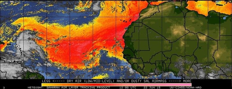
LEVELS OF THE ATMOSPHERE RELATED TO THE SAHARAN AIR LAYER. THE
WAVE WILL PASS THE WINDWARD ISLANDS THROUGH OVERNIGHT...BRINGING
CONTINUED SHOWERS AND THUNDERSTORMS WITH OCCASIONALLY HEAVY
RAINFALL AND GUSTY WINDS TO THE ISLANDS THROUGH MONDAY. A FEW
SHOWERS AND THUNDERSTORMS WILL ALSO IMPACT THE LEEWARD ISLANDS
AS THE TROPICAL WAVE AND UPPER LOW SHIFT W OF THE AREA.
TROPICAL WEATHER DISCUSSION
NWS NATIONAL HURRICANE CENTER MIAMI FL
805 PM EDT SUN JUN 21 2015
A TROPICAL WAVE IS IN THE WESTERN TROPICAL ATLC APPROACHING THE
WINDWARD ISLANDS. THIS WAVE HAS BEEN ACCOMPANIED BY A RELATIVELY
HIGH AMOUNT OF LOWER LEVEL MOISTURE AND IS CURRENTLY INTERACTING
WITH AN UPPER LOW CENTERED NORTH OF THE VIRGIN ISLANDS TO
PRODUCE WIDESPREAD SHOWERS AND THUNDERSTORMS MAINLY SOUTH OF 15N
THROUGHOUT THE WINDWARD ISLANDS. A REGIONAL RADAR MOSAIC IS
SHOWING THE MAIN AREA OF CONVECTION OVER BARBADOS...WHERE AN
OBSERVATION AT 19 UTC INDICATED GUSTS TO 34 KT. THE STRONG
DOWNDRAFTS MAY BE DUE IN PART TO A DRIER PATTERN IN THE MID
LEVELS OF THE ATMOSPHERE RELATED TO THE SAHARAN AIR LAYER. THE
WAVE WILL PASS THE WINDWARD ISLANDS THROUGH OVERNIGHT...BRINGING
CONTINUED SHOWERS AND THUNDERSTORMS WITH OCCASIONALLY HEAVY
RAINFALL AND GUSTY WINDS TO THE ISLANDS THROUGH MONDAY. A FEW
SHOWERS AND THUNDERSTORMS WILL ALSO IMPACT THE LEEWARD ISLANDS
AS THE TROPICAL WAVE AND UPPER LOW SHIFT W OF THE AREA.
0 likes

Re:
Stay safe, Gusty! We had wind gusts to storm force along with welcomed rain earlier today.Gustywind wrote:Yellow alert for a risk ok strong showers and tstorms have been activated for Guadeloupe and Martinica. That's the first yellow code for both of these island as the season has begun the 1st of June. Let's see what could happens from this twave.
Given our Pro Mets of Meteo-France Guadeloupe this twave should concern Guadeloupe near 2AM and spread till 2 PM tommorow increasing showers and tstorms during the second part of the night. Amount of water reaching 60 to 90 millimeters are somewhat expected.
Here is the chart related to the yellow alert for these both islands (Martinica and Guadeloupe).
0 likes
-
Gustywind
- Category 5
- Posts: 12334
- Joined: Mon Sep 03, 2007 7:29 am
- Location: Baie-Mahault, GUADELOUPE
Re: Re:
abajan wrote:Stay safe, Gusty! We had wind gusts to storm force along with welcomed rain earlier today.Gustywind wrote:Yellow alert for a risk ok strong showers and tstorms have been activated for Guadeloupe and Martinica. That's the first yellow code for both of these island as the season has begun the 1st of June. Let's see what could happens from this twave.
Given our Pro Mets of Meteo-France Guadeloupe this twave should concern Guadeloupe near 2AM and spread till 2 PM tommorow increasing showers and tstorms during the second part of the night. Amount of water reaching 60 to 90 millimeters are somewhat expected.
Here is the chart related to the yellow alert for these both islands (Martinica and Guadeloupe).
Oh YEAH, thanks to you, hope you're always safe and dry
0 likes
-
Gustywind
- Category 5
- Posts: 12334
- Joined: Mon Sep 03, 2007 7:29 am
- Location: Baie-Mahault, GUADELOUPE
TROPICAL WEATHER DISCUSSION
NWS NATIONAL HURRICANE CENTER MIAMI FL
805 AM EDT MON JUN 22 2015
COMPLEX TROPICAL WAVE IN THE W TROPICAL ATLC HAS ENTERED THE E
CARIBBEAN AND NOW EXTENDS FROM 17N62W TO INLAND OVER VENEZUELA
NEAR 10N63W MOVING W-NW 20-25 KT OVER THE PAST 24 HOURS. THE
TOTAL PRECIPITABLE WATER IMAGERY SHOWS THE WAVE IS EMBEDDED
WITHIN A SURGE OF DEEP MOISTURE. WAVE IS ALSO INTERACTING WITH
UPPER LEVEL FEATURES PRODUCING AN AREA OF SCATTERED MODERATE TO
ISOLATED STRONG CONVECTION WITHIN 75 NM OF LINE FROM 17N56W TO
ACROSS THE LEEWARD ISLANDS TO NEAR 15N62W. SCATTERED SHOWERS DOT
THE REMAINDER OF THE AREA FROM 12N-22N BETWEEN 55W-62W INCLUDING
THE LESSER ANTILLES AND S OF 15N BETWEEN 62W-69W.
0 likes
-
wxman57

- Moderator-Pro Met

- Posts: 23175
- Age: 68
- Joined: Sat Jun 21, 2003 8:06 pm
- Location: Houston, TX (southwest)
Re: Tropical Wave East of the Southern Leewards
Convection is flaring up as the wave approaches an upper-level low located north of Puerto Rico. The upper low should drift slowly west and dissipate over the next 2-3 days. As it does so, the convection should diminish. Luis - you might get some rain out of this, but no tropical storm.
0 likes
-
cycloneye

- Admin

- Posts: 149505
- Age: 69
- Joined: Thu Oct 10, 2002 10:54 am
- Location: San Juan, Puerto Rico
Re: Tropical Wave East of the Southern Leewards
wxman57 wrote:Convection is flaring up as the wave approaches an upper-level low located north of Puerto Rico. The upper low should drift slowly west and dissipate over the next 2-3 days. As it does so, the convection should diminish. Luis - you might get some rain out of this, but no tropical storm.
Of course no TS.
0 likes
Visit the Caribbean-Central America Weather Thread where you can find at first post web cams,radars
and observations from Caribbean basin members Click Here
and observations from Caribbean basin members Click Here
-
tropicwatch

- Category 5
- Posts: 3426
- Age: 62
- Joined: Sat Jun 02, 2007 10:01 am
- Location: The Villages, Florida
- Contact:
Nice flare up of convection.
0 likes
Tropicwatch
Agnes 72', Eloise 75, Elena 85', Kate 85', Charley 86', Florence 88', Beryl 94', Dean 95', Erin 95', Opal 95', Earl 98', Georges 98', Ivan 2004', Arlene 2005', Dennis 2005', Ida 2009' Debby 2012' Irma 2017' Michael 2018'
Agnes 72', Eloise 75, Elena 85', Kate 85', Charley 86', Florence 88', Beryl 94', Dean 95', Erin 95', Opal 95', Earl 98', Georges 98', Ivan 2004', Arlene 2005', Dennis 2005', Ida 2009' Debby 2012' Irma 2017' Michael 2018'
Re: Tropical Wave Approaching the Leewards
It's been hotter than usual here for late June. Let's see if that translates into an active July.
0 likes

-
cycloneye
- Admin
- Posts: 149505
- Age: 69
- Joined: Thu Oct 10, 2002 10:54 am
- Location: San Juan, Puerto Rico
Re: Tropical Wave Approaching the Leewards
Welcomed rains for some of the islands.

0 likes
Visit the Caribbean-Central America Weather Thread where you can find at first post web cams,radars
and observations from Caribbean basin members Click Here
and observations from Caribbean basin members Click Here
-
lordkev
- Tropical Low

- Posts: 34
- Joined: Tue Sep 09, 2014 10:14 am
- Location: St Kitts, Lesser Antilles
Re: Tropical Wave Approaching the Leewards
We got a decent amount in St Kitts. Not a ton, but with how it's been lately, even a little helps.
0 likes
-
MiamiensisWx
Re: Tropical Wave Approaching the Leewards
Sanibel wrote:It's been hotter than usual here for late June. Let's see if that translates into an active July.
South Florida has had above-average June temperatures many times in recent years, yet nothing happened other than warmer-than-average Gulf SSTs. There really isn't any correlation between surface land temperatures and Atlantic activity.
0 likes
Re: Tropical Wave Approaching the Leewards
MiamiensisWx wrote:Sanibel wrote:It's been hotter than usual here for late June. Let's see if that translates into an active July.
South Florida has had above-average June temperatures many times in recent years, yet nothing happened other than warmer-than-average Gulf SSTs. There really isn't any correlation between surface land temperatures and Atlantic activity.
Except that this year the atmosphere over the GOM is different than the last few years, over all so far this year the shear has been running below average and most important instability has been much higher than the last few years.
0 likes
-
cycloneye
- Admin
- Posts: 149505
- Age: 69
- Joined: Thu Oct 10, 2002 10:54 am
- Location: San Juan, Puerto Rico
Re: Tropical Wave Approaching the Leewards
Some minor damage in some areas of Puerto Rico due to tropical storm force gust of 48 mph clocked by the San Juan NWS.
NWS San Juan @NWSSanJuan · 5m5 minutes ago
View translation
Gust of 48 mph reported at SJU Airport at 205 pm. Ráfagas de 48 mph reportadas en el aeropuerto de San Juan. #prwx

NWS San Juan @NWSSanJuan · 5m5 minutes ago
View translation
Gust of 48 mph reported at SJU Airport at 205 pm. Ráfagas de 48 mph reportadas en el aeropuerto de San Juan. #prwx
0 likes
Visit the Caribbean-Central America Weather Thread where you can find at first post web cams,radars
and observations from Caribbean basin members Click Here
and observations from Caribbean basin members Click Here


-
Dean4Storms
- S2K Supporter

- Posts: 6358
- Age: 63
- Joined: Sun Aug 31, 2003 1:01 pm
- Location: Miramar Bch. FL
-
CYCLONE MIKE
- Category 5
- Posts: 2183
- Joined: Tue Aug 31, 2004 6:04 pm
- Location: Gonzales, LA
Re: Tropical Wave Approaching the Leewards
NDG wrote:MiamiensisWx wrote:Sanibel wrote:It's been hotter than usual here for late June. Let's see if that translates into an active July.
South Florida has had above-average June temperatures many times in recent years, yet nothing happened other than warmer-than-average Gulf SSTs. There really isn't any correlation between surface land temperatures and Atlantic activity.
Except that this year the atmosphere over the GOM is different than the last few years, over all so far this year the shear has been running below average and most important instability has been much higher than the last few years.
I'm not so sure about that. Shear across the gulf and caribbean has been pretty brutal overall except the times it drops for a few days at a time. In fact look for it to increase even more next week when our friend the east coast trough sets up. And like miamiwx said its always hot in June, we're flirting with upper 90's here in South LA and it doesn't lead to anything above normal in the gulf.
0 likes
Who is online
Users browsing this forum: AnnularCane and 174 guests