Text of CPC weekly update of nino 3.4 at +1.4C.
http://www.cpc.noaa.gov/products/analys ... ts-web.pdf
ENSO Updates (2007 thru 2023)
Moderator: S2k Moderators
Forum rules

The posts in this forum are NOT official forecasts and should not be used as such. They are just the opinion of the poster and may or may not be backed by sound meteorological data. They are NOT endorsed by any professional institution or STORM2K. For official information, please refer to products from the National Hurricane Center and National Weather Service.
-
cycloneye

- Admin

- Posts: 149505
- Age: 69
- Joined: Thu Oct 10, 2002 10:54 am
- Location: San Juan, Puerto Rico
Re: ENSO: Mid-June plume of models consensus is peak at +1.6C
0 likes
Visit the Caribbean-Central America Weather Thread where you can find at first post web cams,radars
and observations from Caribbean basin members Click Here
and observations from Caribbean basin members Click Here

Re: ENSO: CPC 6/22/15 update: Nino 3.4 up to +1.4C
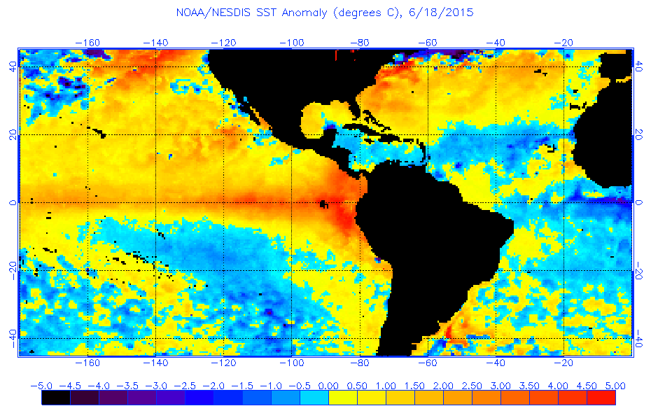
This continues to be a traditional eastern based El Nino, wow!
0 likes

Re: ENSO: CPC 6/22/15 update: Nino 3.4 up to +1.4C
When will the data outage be replaced? The bottom one has been appearing on some days, but the top one (upper right) has been out for a while now.
Image courtesy of NWS NOAA:
Image courtesy of NWS NOAA:
0 likes
This post is NOT AN OFFICIAL FORECAST and should not be used as such. It is just the opinion of the poster and may or may not be backed by sound meteorological data. It is NOT endorsed by any professional institution including storm2k.org. For Official Information please refer to the NHC and NWS products.
-
cycloneye
- Admin
- Posts: 149505
- Age: 69
- Joined: Thu Oct 10, 2002 10:54 am
- Location: San Juan, Puerto Rico
Re: ENSO: CPC 6/22/15 update: Nino 3.4 up to +1.4C
BoM update of 6/23/15 has El Nino consolidating but still they don't say how the peak will be.
http://www.bom.gov.au/climate/enso/
http://www.bom.gov.au/climate/enso/
0 likes
Visit the Caribbean-Central America Weather Thread where you can find at first post web cams,radars
and observations from Caribbean basin members Click Here
and observations from Caribbean basin members Click Here


Re: ENSO: CPC 6/22/15 update: Nino 3.4 up to +1.4C
cycloneye wrote:BoM update of 6/23/15 has El Nino consolidating but still they don't say how the peak will be.
http://www.bom.gov.au/climate/enso/
Their model average for June continued to grow bigger. They have it at 2C by September and higher by November. The actual BOM (POAMA) prediction is around 1.6C for November's monthly average. Given we are already at 1.4C I'd say that's a little conservative.
0 likes
The above post and any post by Ntxw is NOT an official forecast and should not be used as such. It is just the opinion of the poster and may or may not be backed by sound meteorological data. It is NOT endorsed by any professional institution including Storm2k. For official information, please refer to NWS products.
Help support Storm2K!
-
TeamPlayersBlue

- Category 5

- Posts: 3531
- Joined: Tue Feb 02, 2010 1:44 am
- Location: Denver/Applewood, CO
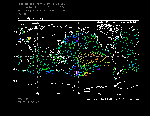
I love the enthusiasm in this thread every day  . El nino is right on schedule. My question is what are the analogs? I saw 1906 and 1973. Havent done my own research on it but when it comes to our winter here in Houston, i like the '73 analog.
0 likes
Personal Forecast Disclaimer:
The posts in this forum are NOT official forecast and should not be used as such. They are just the opinion of the poster and may or may not be backed by sound meteorological data. They are NOT endorsed by any professional institution or storm2k.org. For official information, please refer to the NHC and NWS products.
The posts in this forum are NOT official forecast and should not be used as such. They are just the opinion of the poster and may or may not be backed by sound meteorological data. They are NOT endorsed by any professional institution or storm2k.org. For official information, please refer to the NHC and NWS products.
Re:
TeamPlayersBlue wrote:I love the enthusiasm in this thread every day
It's a very good question, El Nino's as strong as this is predicted be, are rare and there isn't a lot to go by. The coming winter across the NH will definitely be dominated by the Nino as it has major influences in the cold season than it does the warm season as strong as it will be.
0 likes
The above post and any post by Ntxw is NOT an official forecast and should not be used as such. It is just the opinion of the poster and may or may not be backed by sound meteorological data. It is NOT endorsed by any professional institution including Storm2k. For official information, please refer to NWS products.
Help support Storm2K!
Help support Storm2K!
-
TeamPlayersBlue
- Category 5
- Posts: 3531
- Joined: Tue Feb 02, 2010 1:44 am
- Location: Denver/Applewood, CO
Dec 1905- Mar 1906
Dec '72 - Mar '73
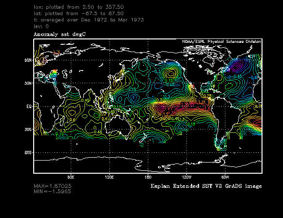
1906 looked to be a bit of a modiki Nino, maybe it was a good one for last year. Not sure. '73 looks almost about as close as we can get at the moment. Again ive only looked at a few years. The warm pool in the GOA and obviously the warm Pacific. It is missing the warm water off the Cali coast though.
Last edited by TeamPlayersBlue on Tue Jun 23, 2015 12:25 pm, edited 1 time in total.
0 likes
Personal Forecast Disclaimer:
The posts in this forum are NOT official forecast and should not be used as such. They are just the opinion of the poster and may or may not be backed by sound meteorological data. They are NOT endorsed by any professional institution or storm2k.org. For official information, please refer to the NHC and NWS products.
The posts in this forum are NOT official forecast and should not be used as such. They are just the opinion of the poster and may or may not be backed by sound meteorological data. They are NOT endorsed by any professional institution or storm2k.org. For official information, please refer to the NHC and NWS products.
Re:
TeamPlayersBlue wrote:1906 looked to be a bit of a modiki Nino, maybe it was a good one for last year. Not sure. '73 looks almost about as close as we can get at the moment. Again ive only looked at a few years. The warm pool in the GOA and obviously the warm Pacific. It is missing the warm water off the Cali coast though.
I believe the period (Larrywx) from late 1904-1906 was a very long multi-year El Nino 1905 being the apex of a strong. Similar to what 2014-2016 might be (I'm disregarding the new methodology for this purpose from the CPC). It was very wet and cold times for the southern US.
0 likes
The above post and any post by Ntxw is NOT an official forecast and should not be used as such. It is just the opinion of the poster and may or may not be backed by sound meteorological data. It is NOT endorsed by any professional institution including Storm2k. For official information, please refer to NWS products.
Help support Storm2K!
Help support Storm2K!
Here comes the next big WWB moving towards the dateline. It has MJO support, very much like in March and May. I think like those it will be stronger as we get closer than what guidance has


WPAC lid will go off again, probably a few typhoons and possibly a STY to accompany. As it moves eastward the CPAC and EPAC should gear up sometime early July.
WPAC lid will go off again, probably a few typhoons and possibly a STY to accompany. As it moves eastward the CPAC and EPAC should gear up sometime early July.
0 likes
The above post and any post by Ntxw is NOT an official forecast and should not be used as such. It is just the opinion of the poster and may or may not be backed by sound meteorological data. It is NOT endorsed by any professional institution including Storm2k. For official information, please refer to NWS products.
Help support Storm2K!
Help support Storm2K!
-
TeamPlayersBlue
- Category 5
- Posts: 3531
- Joined: Tue Feb 02, 2010 1:44 am
- Location: Denver/Applewood, CO
How does the MJO work with Typhoons again? In the location of the MJO is where Typhoons become favorable?
0 likes
Personal Forecast Disclaimer:
The posts in this forum are NOT official forecast and should not be used as such. They are just the opinion of the poster and may or may not be backed by sound meteorological data. They are NOT endorsed by any professional institution or storm2k.org. For official information, please refer to the NHC and NWS products.
The posts in this forum are NOT official forecast and should not be used as such. They are just the opinion of the poster and may or may not be backed by sound meteorological data. They are NOT endorsed by any professional institution or storm2k.org. For official information, please refer to the NHC and NWS products.
Re:
TeamPlayersBlue wrote:How does the MJO work with Typhoons again? In the location of the MJO is where Typhoons become favorable?
The MJO is associated with regions of upward motion and strong lift. Wherever it goes, if it is coherent, tends to boost cyclogenesis and strength of tropical systems. Phase 6/7 as predicted is wpac territory into the central Pacific, and are associated with westerly winds typically.
0 likes
The above post and any post by Ntxw is NOT an official forecast and should not be used as such. It is just the opinion of the poster and may or may not be backed by sound meteorological data. It is NOT endorsed by any professional institution including Storm2k. For official information, please refer to NWS products.
Help support Storm2K!
Help support Storm2K!
-
cycloneye
- Admin
- Posts: 149505
- Age: 69
- Joined: Thu Oct 10, 2002 10:54 am
- Location: San Juan, Puerto Rico
Re:
Ntxw wrote:Here comes the next big WWB moving towards the dateline. It has MJO support, very much like in March and May. I think like those it will be stronger as we get closer than what guidance has
http://i62.tinypic.com/1427jia.png
http://i62.tinypic.com/33kvd46.gif
WPAC lid will go off again, probably a few typhoons and possibly a STY to accompany. As it moves eastward the CPAC and EPAC should gear up sometime early July.
This may be the nail in the coffin to have a strong El Nino by September?
0 likes
Visit the Caribbean-Central America Weather Thread where you can find at first post web cams,radars
and observations from Caribbean basin members Click Here
and observations from Caribbean basin members Click Here
Re: Re:
cycloneye wrote:Ntxw wrote:Here comes the next big WWB moving towards the dateline. It has MJO support, very much like in March and May. I think like those it will be stronger as we get closer than what guidance has
http://i62.tinypic.com/1427jia.png
http://i62.tinypic.com/33kvd46.gif
WPAC lid will go off again, probably a few typhoons and possibly a STY to accompany. As it moves eastward the CPAC and EPAC should gear up sometime early July.
This may be the nail in the coffin to have a strong El Nino by September?
Yeah the readings are already moderate, no signs of weakening with next WWB strong Nino is almost a lock. They peak in fall and winter so the 1.4 now is not nearly peak.
0 likes
The above post and any post by Ntxw is NOT an official forecast and should not be used as such. It is just the opinion of the poster and may or may not be backed by sound meteorological data. It is NOT endorsed by any professional institution including Storm2k. For official information, please refer to NWS products.
Help support Storm2K!
Help support Storm2K!
-
MississippiWx

- S2K Supporter

- Posts: 1720
- Joined: Sat Aug 14, 2010 1:44 pm
- Location: Hattiesburg, Mississippi
Re: ENSO Updates
Another downwelling oceanic Kelvin wave event needs to get going. Could this WWB do the trick, Ntwx?
0 likes
This post is not an official forecast and should not be used as such. It is just the opinion of MississippiWx and may or may not be backed by sound meteorological data. It is not endorsed by any professional institution including storm2k.org. For Official Information please refer to the NHC and NWS products.
Re: ENSO Updates
MississippiWx wrote:Another downwelling oceanic Kelvin wave event needs to get going. Could this WWB do the trick, Ntwx?
We've had 2 strong okw since March (roughly 45-60 days apart) each raising the bar, the May warming us to moderate weekly readings, this next okw will seal the deal as cycloneye says. The big difference from last year has been the supporting continuous WWBs
The question is will it be enough to get it over 2C and qualify as a super Nino?
0 likes
The above post and any post by Ntxw is NOT an official forecast and should not be used as such. It is just the opinion of the poster and may or may not be backed by sound meteorological data. It is NOT endorsed by any professional institution including Storm2k. For official information, please refer to NWS products.
Help support Storm2K!
Help support Storm2K!
-
TeamPlayersBlue
- Category 5
- Posts: 3531
- Joined: Tue Feb 02, 2010 1:44 am
- Location: Denver/Applewood, CO
Thanks Ntx, not sure why i didnt put two and two together with all the rising air from an MJO event. Thanks again!
0 likes
Personal Forecast Disclaimer:
The posts in this forum are NOT official forecast and should not be used as such. They are just the opinion of the poster and may or may not be backed by sound meteorological data. They are NOT endorsed by any professional institution or storm2k.org. For official information, please refer to the NHC and NWS products.
The posts in this forum are NOT official forecast and should not be used as such. They are just the opinion of the poster and may or may not be backed by sound meteorological data. They are NOT endorsed by any professional institution or storm2k.org. For official information, please refer to the NHC and NWS products.
-
euro6208
Re: ENSO Updates
GFS hinting of a 911mb typhoon during the next few days.
More WWB to further warm the nino...
More WWB to further warm the nino...
0 likes

Re:
Ntxw wrote:Here comes the next big WWB moving towards the dateline. It has MJO support, very much like in March and May. I think like those it will be stronger as we get closer than what guidance has
WPAC lid will go off again, probably a few typhoons and possibly a STY to accompany. As it moves eastward the CPAC and EPAC should gear up sometime early July.
Could you please tell me the link where you get the WWB forecast from?
0 likes
Re: Re:
WALL-E wrote:
Could you please tell me the link where you get the WWB forecast from?
Can see it here on Mike Ventrice's page : http://mikeventrice.weebly.com/hovmollers.html
Look for time longitude plot for 5N-5S of 850mb zonal wind (anomaly or totals).
0 likes
All posts by Dean_175 are NOT official forecasts and should not be used as such. They are just the opinion of the poster and may or may not be backed by sound meteorological data. They are NOT endorsed by any professional institution or storm2k.org. For official information, please refer to the NHC and NWS products.
Who is online
Users browsing this forum: AnnularCane and 167 guests