This El Nino will have another Kelvin Wave to work with and will probably surface or reinforce the current one and probably peak around September some time and maintain around peak for a month or 2 before it starts to decline and I do think it will be gone by sometime in winter based on the negative anomalies spreading under the warm anomalies
The posts in this forum are NOT official forecast and should not be used as such. They are just the opinion of the poster and may or may not be backed by sound meteorological data. They are NOT endorsed by any professional institution or storm2k.org. For official information, please refer to the NHC and NWS products
ENSO Updates (2007 thru 2023)
Moderator: S2k Moderators
Forum rules

The posts in this forum are NOT official forecasts and should not be used as such. They are just the opinion of the poster and may or may not be backed by sound meteorological data. They are NOT endorsed by any professional institution or STORM2K. For official information, please refer to products from the National Hurricane Center and National Weather Service.
-
Hurricaneman

- Category 5

- Posts: 7404
- Age: 45
- Joined: Tue Aug 31, 2004 3:24 pm
- Location: central florida
-
Yellow Evan

- Professional-Met

- Posts: 16240
- Age: 27
- Joined: Fri Jul 15, 2011 12:48 pm
- Location: Henderson, Nevada/Honolulu, HI
- Contact:
Re:
Hurricaneman wrote: I do think it will be gone by sometime in winter based on the negative anomalies spreading under the warm anomalies
The posts in this forum are NOT official forecast and should not be used as such. They are just the opinion of the poster and may or may not be backed by sound meteorological data. They are NOT endorsed by any professional institution or storm2k.org. For official information, please refer to the NHC and NWS products
That usually happen sin July during El Ninos.
This El Nino will weaken when the WPAC cools down too much, causing WWB's to actually bring colder water, or when the wWWB's stop altogether.
0 likes


Looks like its holding at 1.4C yet again this week, AMJ ONI came out to be 0.9C
0 likes
The above post and any post by Ntxw is NOT an official forecast and should not be used as such. It is just the opinion of the poster and may or may not be backed by sound meteorological data. It is NOT endorsed by any professional institution including Storm2k. For official information, please refer to NWS products.
Help support Storm2K!
-
xtyphooncyclonex

- Category 5
- Posts: 3891
- Age: 24
- Joined: Sat Dec 08, 2012 9:07 am
- Location: Cebu City
- Contact:
Re: ENSO Updates
This week, strong/super Niño over the eastern regions
Niño 4: +1.0C
Niño 3.4: +1.4C
Niño 3: +2.0C
Niño 1+2: +2.7C
Niño 4: +1.0C
Niño 3.4: +1.4C
Niño 3: +2.0C
Niño 1+2: +2.7C
0 likes
REMINDER: My opinions that I, or any other NON Pro-Met in this forum, are unofficial. Please do not take my opinions as an official forecast and warning. I am NOT a meteorologist. Following my forecasts blindly may lead to false alarm, danger and risk if official forecasts from agencies are ignored.


-
cycloneye

- Admin

- Posts: 149508
- Age: 69
- Joined: Thu Oct 10, 2002 10:54 am
- Location: San Juan, Puerto Rico
Re: CPC update of 7/6/15: Nino 3.4 at +1.4C / ONI up to +0.9C
Here is the text of the CPC update that has Nino 3.4 at +1.4C.The ONI goes up from +0.7C to +0.9C.
http://www.cpc.noaa.gov/products/analys ... ts-web.pdf
http://www.cpc.noaa.gov/products/analys ... ts-web.pdf
0 likes
Visit the Caribbean-Central America Weather Thread where you can find at first post web cams,radars
and observations from Caribbean basin members Click Here
and observations from Caribbean basin members Click Here
Re: ENSO Updates
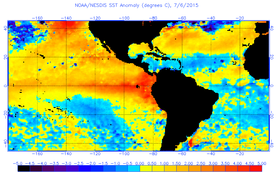
NDG wrote:Wow, the eastern equatorial Pacific is on fire! Modoki where? lol
http://www.ospo.noaa.gov/data/sst/anoma ... 6.2015.gif
Caribbean wind shear has reflected it well. 70-90 knots of shear almost the entire run of most guidance somewhere in the Carib! Definitely influenced by the canonical Nino.
0 likes
The above post and any post by Ntxw is NOT an official forecast and should not be used as such. It is just the opinion of the poster and may or may not be backed by sound meteorological data. It is NOT endorsed by any professional institution including Storm2k. For official information, please refer to NWS products.
Help support Storm2K!
Help support Storm2K!
-
cycloneye
- Admin
- Posts: 149508
- Age: 69
- Joined: Thu Oct 10, 2002 10:54 am
- Location: San Juan, Puerto Rico
Re: CPC update of 7/6/15: Nino 3.4 at +1.4C / ONI up to +0.9C
Ntxw,what is your read on the +0.9C ONI that jumped from +0.7C?
0 likes
Visit the Caribbean-Central America Weather Thread where you can find at first post web cams,radars
and observations from Caribbean basin members Click Here
and observations from Caribbean basin members Click Here
The MJO this weekend set all time records (since kept) it beat the big March event to be strongest amplitude during any month of the year. 2015 now holds the top 2 spots in two seperate events and both happening over the Pacific phases.
0 likes
The above post and any post by Ntxw is NOT an official forecast and should not be used as such. It is just the opinion of the poster and may or may not be backed by sound meteorological data. It is NOT endorsed by any professional institution including Storm2k. For official information, please refer to NWS products.
Help support Storm2K!
Help support Storm2K!

The ESOI for June was -1.9 , which is the most negative June reading since at least 1950.
0 likes
All posts by Dean_175 are NOT official forecasts and should not be used as such. They are just the opinion of the poster and may or may not be backed by sound meteorological data. They are NOT endorsed by any professional institution or storm2k.org. For official information, please refer to the NHC and NWS products.
-
cycloneye
- Admin
- Posts: 149508
- Age: 69
- Joined: Thu Oct 10, 2002 10:54 am
- Location: San Juan, Puerto Rico
Re: CPC update of 7/6/15: Nino 3.4 at +1.4C / ONI up to +0.9C
The Aussies boost El Nino.
http://www.bom.gov.au/climate/enso/#tabs=Overview
Tropical cyclone activity may boost El Niño
Issued on 7 July 2015 | Product Code IDCKGEWW00
The 2015 El Niño is likely to strengthen in the coming weeks, largely due to recent tropical cyclone activity. Several tropical cyclones, including a rare July cyclone in the southern hemisphere, have resulted in a strong reversal of trade winds near the equator. This is likely to increase temperatures below the surface of the tropical Pacific Ocean, which may in turn raise sea surface temperatures further in the coming months.
All international climate models surveyed by the Bureau of Meteorology suggest El Niño will persist until at least the end of 2015. Models also indicate that further warming is likely. Historically, El Niño reaches peak strength during late spring or early summer.
El Niño is typically associated with below-average winter and spring rainfall over eastern Australia and above-average daytime temperatures over the southern half of the country during the second half of the year. However, the strength of El Niño does not always determine the strength of its effect on Australia's climate. Read more about how El Niño might affect Australia.
Many other factors, such as the state of the Indian Ocean, also influence Australia's climate. The Indian Ocean Dipole (IOD) is currently neutral. Of the five international models that provide IOD outlooks, three suggest a positive IOD is likely during the southern hemisphere spring. A positive IOD is typically associated with reduced winter and spring rainfall over parts of southern and central Australia.
Weekly sea surface temperatures
Over the past fortnight, sea surface temperature (SST) anomalies have continued to increase in the eastern equatorial Pacific. Warm anomalies extend along the equator from the South American coastline to just west of the Date Line, with anomalies for the week ending 5 July in excess of +2 °C in much of the eastern equatorial Pacific, reaching more than +3 °C in small areas.
All five NINO indices again exceeded +1 °C this week, and NINO1 NINO2 and NINO3 are all at their warmest sustained weekly value since the 1997–98 El Niño.
Warm anomalies persist across most of the northeast of the Pacific Basin, extending down the western coastline of North America and into South America. Warm anomalies are also present along the east coast of Australia, in areas to Australia's west, and across much of the Indian Ocean.
0 likes
Visit the Caribbean-Central America Weather Thread where you can find at first post web cams,radars
and observations from Caribbean basin members Click Here
and observations from Caribbean basin members Click Here
Re: ENSO: BoM update 7/7/15: Tropical activity may boost El Nino
MJO is testing the bounds of this chart

0 likes
The above post and any post by Ntxw is NOT an official forecast and should not be used as such. It is just the opinion of the poster and may or may not be backed by sound meteorological data. It is NOT endorsed by any professional institution including Storm2k. For official information, please refer to NWS products.
Help support Storm2K!
Help support Storm2K!
-
cycloneye
- Admin
- Posts: 149508
- Age: 69
- Joined: Thu Oct 10, 2002 10:54 am
- Location: San Juan, Puerto Rico
Re: CPC Blog:Keep calm,Stop obsessing of weekly changes of ENSO
Very interesting blog that CPC has made about the weekly obsession theme of changes of ENSO.
Excerpt of blog.
“El Niño is Strong!”
“No, it’s Moderate!”
“But the [insert your favorite ENSO indicator here]
is the largest it’s been since the El Niño of 1997-98!”
We are now nearing 1.5 degrees Celsius in the Niño-3.4 index for a 7-day or weekly average. Among the post-college age crowd who can remember it (yes, this officially means you’re old), the level of warmth in sea surface temperatures this time of year harkens back to 1997-98 El Niño, which ended up becoming a record strength event.
Are these weekly numbers impressive? Yes. But when a weekly value hits 1.5°C is El Niño instantly considered strong? I’d argue no. While a short-term (daily or weekly) number might be striking, it shouldn’t be used as an indicator of El Niño strength unless it is carefully placed into a larger context. Here are some reasons to be careful about gauging El Niño strength on a sub-monthly basis:
http://www.climate.gov/news-features/bl ... anges-enso
0 likes
Visit the Caribbean-Central America Weather Thread where you can find at first post web cams,radars
and observations from Caribbean basin members Click Here
and observations from Caribbean basin members Click Here
Very interesting the recent blog good stuff. They are seeming a little conservative, definitely agree a weekly reading doesn't an El Nino make. Though as mentioned by the poster taken into large context it does matter. The near 1.5C (1.4C to be exact) has been ongoing since early June and greater than 1C since late April. This is nearly a full season worth not the fleeting near 1C for a week back in November. There is no sign of slowing down so I think a little more credit is due to the strengthening ENSO event.
0 likes
The above post and any post by Ntxw is NOT an official forecast and should not be used as such. It is just the opinion of the poster and may or may not be backed by sound meteorological data. It is NOT endorsed by any professional institution including Storm2k. For official information, please refer to NWS products.
Help support Storm2K!
Help support Storm2K!
-
Hurricaneman
- Category 5
- Posts: 7404
- Age: 45
- Joined: Tue Aug 31, 2004 3:24 pm
- Location: central florida
Re: CPC Blog:Keep calm,Stop obsessing of weekly changes of ENSO
The waters near New Guinea are below normal which may be a sign that while El nino is going strong it may only last until Spring as we all know we have to monitor that area to detirmine how long this el nino lasts but El Nino is going to be with us through 2015 and maybe the beginning of 2016
The posts in this forum are NOT official forecast and should not be used as such. They are just the opinion of the poster and may or may not be backed by sound meteorological data. They are NOT endorsed by any professional institution or storm2k.org. For official information, please refer to the NHC and NWS products
The posts in this forum are NOT official forecast and should not be used as such. They are just the opinion of the poster and may or may not be backed by sound meteorological data. They are NOT endorsed by any professional institution or storm2k.org. For official information, please refer to the NHC and NWS products
0 likes
Yes that's true- a weekly reading is definitely not enough to be too significant in the long run.The weeklies can be misleading because the ONI is always going to be less than the peak weekly value of any Nino. So you need to take the weeklies with a grain of salt. A strong El Nino is often defined as an event where the ONI reaches 1.5C for 3 consecutive months. The 1997 event saw ONI reach 2.0C for 5 consecutive months, while 1982 saw 2.0C for 3 consecutive months. Since ONI is a 3 month average of nino3.4, you are going to have some weeks well above the 1.5C (near 2.0C) in a strong El Nino- while in a "super El Nino" you are going to see weeks with values of 2.5C or higher. 1997 had some weeklies at 2.8C in December.
On the other hand, because this El Nino has not yet peaked (according to models and the observation that the majority of events peak during winter)- I think weeklies near 1.5C in July support the idea that we will see a strong El Nino.
On the other hand, because this El Nino has not yet peaked (according to models and the observation that the majority of events peak during winter)- I think weeklies near 1.5C in July support the idea that we will see a strong El Nino.
0 likes
All posts by Dean_175 are NOT official forecasts and should not be used as such. They are just the opinion of the poster and may or may not be backed by sound meteorological data. They are NOT endorsed by any professional institution or storm2k.org. For official information, please refer to the NHC and NWS products.
The easterlies and upwelling KW back in early to mid June essentially did nothing to the Nino. 2C anomalies (per buoys) continues to overspread much of Nino 3.4. Its been two fronts in favor of it now, below warm pool expanding again and above warming westerly winds. I'm interested to see the MEI update and see if this is ranking as a progressing top 5 event.
0 likes
The above post and any post by Ntxw is NOT an official forecast and should not be used as such. It is just the opinion of the poster and may or may not be backed by sound meteorological data. It is NOT endorsed by any professional institution including Storm2k. For official information, please refer to NWS products.
Help support Storm2K!
Help support Storm2K!
-
cycloneye
- Admin
- Posts: 149508
- Age: 69
- Joined: Thu Oct 10, 2002 10:54 am
- Location: San Juan, Puerto Rico
Re: CPC Blog:Keep calm,Stop obsessing of weekly changes of ENSO
Big thing here.
WSI Energy Weather @WSI_Energy · 11h11 hours ago
This is a BIG deal! Atmospheric ENSO index at +3 sigma! Strongest for an amplifying July El Nino dating back to 1948.

WSI Energy Weather @WSI_Energy · 11h11 hours ago
This is a BIG deal! Atmospheric ENSO index at +3 sigma! Strongest for an amplifying July El Nino dating back to 1948.
0 likes
Visit the Caribbean-Central America Weather Thread where you can find at first post web cams,radars
and observations from Caribbean basin members Click Here
and observations from Caribbean basin members Click Here
-
CrazyC83
- Professional-Met
- Posts: 34315
- Joined: Tue Mar 07, 2006 11:57 pm
- Location: Deep South, for the first time!
I saw quite a few runs go over +4.0C on this, and maybe as high as +5.0C since it is off the charts?
https://twitter.com/EricBlake12/status/ ... 8185196544
https://twitter.com/EricBlake12/status/ ... 8185196544
0 likes
Who is online
Users browsing this forum: No registered users and 302 guests