
AL, 92, 2015071106, , BEST, 0, 359N, 776W, 15, 1009, DB, 0, , 0, 0, 0, 0, 0, 0, 0, 0, 0, , 0, , 0, 0, GENESIS005, , 0, , 0, 0, 0, 0, genesis-num, 005,
AL, 92, 2015071112, , BEST, 0, 357N, 770W, 15, 1009, DB, 0, , 0, 0, 0, 0, 0, 0, 0, 0, 0, , 0, , 0, 0, GENESIS005, , 0, , 0, 0, 0, 0, genesis-num, 005,
AL, 92, 2015071118, , BEST, 0, 356N, 762W, 15, 1009, DB, 0, , 0, 0, 0, 0, 0, 0, 0, 0, 0, , 0, , 0, 0, GENESIS005, , 0, , 0, 0, 0, 0, genesis-num, 005,
AL, 92, 2015071200, , BEST, 0, 356N, 753W, 20, 1012, LO, 34, NEQ, 0, 0, 0, 0, 1014, 150, 60, 0, 0, L, 0, , 0, 0, INVEST, M, 0, , 0, 0, 0, 0, genesis-num, 005, SPAWNINVEST, al752015 to al922015,
ZCZC MIATWOAT ALL
TTAA00 KNHC DDHHMM
TROPICAL WEATHER OUTLOOK
NWS NATIONAL HURRICANE CENTER MIAMI FL
200 AM EDT SUN JUL 12 2015
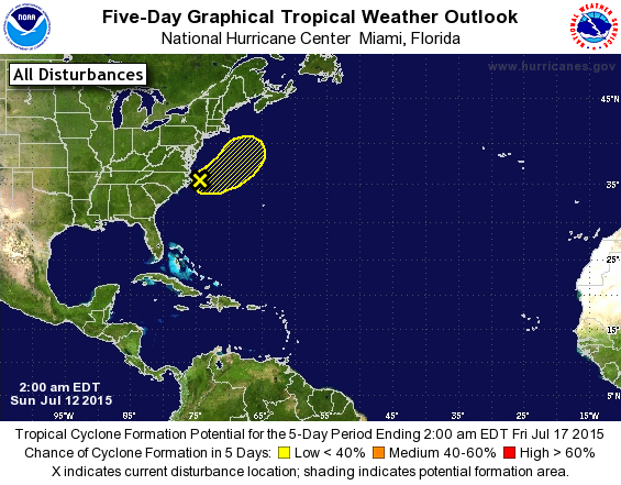
For the North Atlantic...Caribbean Sea and the Gulf of Mexico:
1. A non-tropical low pressure system has moved off of the east coast
of the United States and is located about 70 miles east of Cape
Hatteras, North Carolina. Although showers and thunderstorms have
become concentrated near the center of the low, environmental
conditions are expected to only be marginally conducive for
development of a subtropical or tropical cyclone during the next
day or so while the low moves eastward and then northeastward away
from the United States.
* Formation chance through 48 hours...low...20 percent
* Formation chance through 5 days...low...20 percent
Forecaster Stewart
Live IR
http://wwwghcc.msfc.nasa.gov/cgi-bin/get-goes?satellite=GOES-E%20CONUS&lat=35&lon=-75&info=ir&zoom=2&width=1000&height=800&quality=92&type=Animation&palette=ir1.pal&numframes=10&mapcolor=gray


