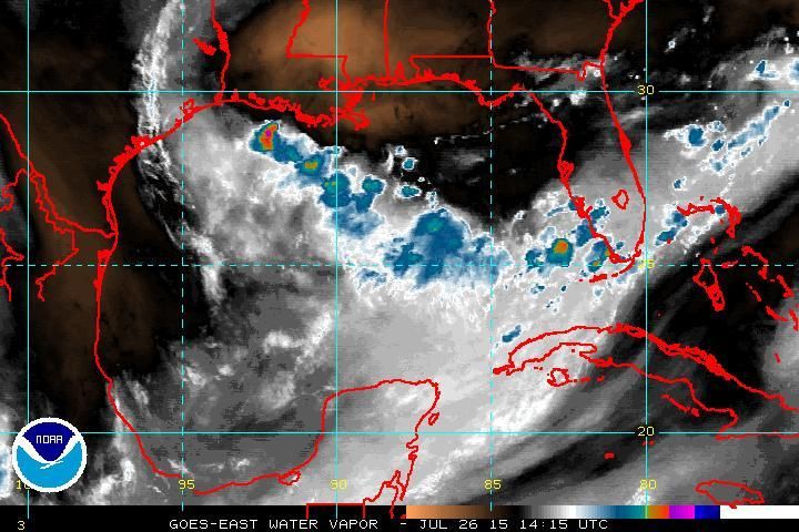
Weak low in NE Gulf of Mexico: (Is Invest 95L)

This is the general tropical discussion area. Anyone can take their shot at predicting a storms path.

Moderator: S2k Moderators

Forum rules

The posts in this forum are NOT official forecasts and should not be used as such. They are just the opinion of the poster and may or may not be backed by sound meteorological data. They are NOT endorsed by any professional institution or STORM2K. For official information, please refer to products from the National Hurricane Center and National Weather Service.

Help Support Storm2K
Message
Author
NCSTORMMAN

Re: Re:

#61 Postby NCSTORMMAN » Sun Jul 26, 2015 1:22 am

Hammy wrote:
NCSTORMMAN wrote:
Hammy wrote:latest GFS running, doesn't seem to develop anything at all now through the entire run.


So, the odds are going down right? It looks like all the convection is dying in the gulf and in the atlantic. At least to me it does but I am no weatherman. Am I the only one who feels that way?


There is still some turning in the Gulf, but much of the convection may have been from heating of the day, though there is a bit of new convection forming. I would say for the time being that it's done.


I agree but again I am no weatherman.
0 likes   

User avatar
Nimbus
Category 5
Category 5
Posts: 5302
Joined: Mon Jul 19, 2004 10:54 am

Re: Weak low in NE Gulf of Mexico

#62 Postby Nimbus » Sun Jul 26, 2015 5:27 am

The Tampa buoy dropped to 1010 as the low dropped southwest over its location.
Once the daytime heating kicks off some convection, the circulation should be evident in the radar echoes.
Often these surface lows just dissipate, but with surface pressure of 1010, falling shear and ULL building in I would up the percentages for tropical storm formation.

Good news for Tampa bay area is that the it appears the LLC once formed will drift SW away from the area that has been receiving the flooding rains.
0 likes   

User avatar
tropicwatch
Category 5
Category 5
Posts: 3386
Age: 61
Joined: Sat Jun 02, 2007 10:01 am
Location: Panama City Florida
Contact:

#63 Postby tropicwatch » Sun Jul 26, 2015 8:02 am

0 likes   
Tropicwatch


Agnes 72', Eloise 75, Elena 85', Kate 85', Charley 86', Florence 88', Beryl 94', Dean 95', Erin 95', Opal 95', Earl 98', Georges 98', Ivan 2004', Arlene 2005', Dennis 2005', Ida 2009' Debby 2012' Irma 2017' Michael 2018'

TheStormExpert

#64 Postby TheStormExpert » Sun Jul 26, 2015 8:16 am

:uarrow: Yes I saw that, and there is also a slightly more definable low just off of Jacksonville. Though both are elongated.

Image
0 likes   

User avatar
gatorcane
S2K Supporter
S2K Supporter
Posts: 23691
Age: 47
Joined: Sun Mar 13, 2005 3:54 pm
Location: Boca Raton, FL

#65 Postby gatorcane » Sun Jul 26, 2015 9:27 am

Saved loop, cyclonic turning evident with some new thunderstorms trying to get going off the coast of SW Florida, looks like maybe something a little south of Tampa Bay?

Also radar out of Tampa:
http://www.srh.noaa.gov/tbw/

Image
0 likes   

Sanibel
Category 5
Category 5
Posts: 10375
Joined: Mon Aug 30, 2004 11:06 pm
Location: Offshore SW Florida

Re: Weak low in NE Gulf of Mexico

#66 Postby Sanibel » Sun Jul 26, 2015 9:53 am

That's a mess. The upper doesn't look matched with the lower.


Good downpour this am.


Conditions aren't quite there yet. Give it another week or so.
0 likes   

lovingseason2013
Tropical Depression
Tropical Depression
Posts: 71
Joined: Sat Oct 12, 2013 7:54 am
Location: Pensacola, FL

Re: Weak low in NE Gulf of Mexico

#67 Postby lovingseason2013 » Sun Jul 26, 2015 10:07 am

Has SE Florida been able to get any of the rains? or will they get some relief?
0 likes   

lovingseason2013
Tropical Depression
Tropical Depression
Posts: 71
Joined: Sat Oct 12, 2013 7:54 am
Location: Pensacola, FL

Re: Weak low in NE Gulf of Mexico

#68 Postby lovingseason2013 » Sun Jul 26, 2015 10:11 am

Has SE Florida been able to get any of the rains? or will they get some relief?
0 likes   

User avatar
NDG
S2K Supporter
S2K Supporter
Posts: 15446
Joined: Sun Jul 09, 2006 10:14 pm
Location: Orlando, FL

#69 Postby NDG » Sun Jul 26, 2015 10:15 am

:uarrow: yes, SE FL has been seen some much needed rains thanks to the SW flow.
0 likes   

User avatar
NDG
S2K Supporter
S2K Supporter
Posts: 15446
Joined: Sun Jul 09, 2006 10:14 pm
Location: Orlando, FL

Re:

#70 Postby NDG » Sun Jul 26, 2015 10:21 am

gatorcane wrote:Saved loop, cyclonic turning evident with some new thunderstorms trying to get going off the coast of SW Florida, looks like maybe something a little south of Tampa Bay?

Also radar out of Tampa:
http://www.srh.noaa.gov/tbw/

http://i.imgur.com/qbGbkF6.gif


Circulation is weak and broad, too much shear and now some dry air is pushing in at mid levels.

Image
0 likes   

NCSTORMMAN

Re: Re:

#71 Postby NCSTORMMAN » Sun Jul 26, 2015 10:27 am

NDG wrote:
gatorcane wrote:Saved loop, cyclonic turning evident with some new thunderstorms trying to get going off the coast of SW Florida, looks like maybe something a little south of Tampa Bay?

Also radar out of Tampa:
http://www.srh.noaa.gov/tbw/

http://i.imgur.com/qbGbkF6.gif


Circulation is weak and broad, too much shear and now some dry air is pushing in at mid levels.

Image


In other words it has no chance? Right lol?
0 likes   

TheStormExpert

#72 Postby TheStormExpert » Sun Jul 26, 2015 10:34 am

:uarrow: It seems in El Niños that the Northern half of the GoM is usually unfavorable while the southern half is the more favorable half.
0 likes   

User avatar
NDG
S2K Supporter
S2K Supporter
Posts: 15446
Joined: Sun Jul 09, 2006 10:14 pm
Location: Orlando, FL

#73 Postby NDG » Sun Jul 26, 2015 10:51 am

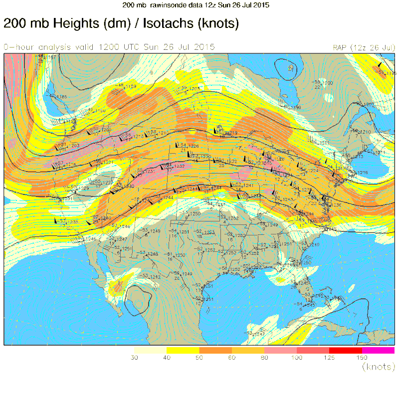
:uarrow: The current unfavorable conditions over the northeastern GOM has to do more with the current heat ridge over the south central US.
The subtropical jet is way north of the GOM, later on in late summer into early fall is when conditions over the northern GOM become more hostile as the subtropical jet enforced by the current El Niño becomes dominant further south across this area.

Image
0 likes   

TheStormExpert

#74 Postby TheStormExpert » Sun Jul 26, 2015 11:15 am

Just two months ago we were talking drought busting and dangerous flooding rains in Texas, now there is a death ridge over Texas. Our weather has been weird here in the U.S. :eek:
0 likes   

User avatar
gatorcane
S2K Supporter
S2K Supporter
Posts: 23691
Age: 47
Joined: Sun Mar 13, 2005 3:54 pm
Location: Boca Raton, FL

#75 Postby gatorcane » Sun Jul 26, 2015 1:14 pm

Well now the UKMET is back to the EGOM area pulling it slowly north and shows a 1005MB low over the Georgia/SC border pulling NE:

Image
0 likes   

crimi481
Category 2
Category 2
Posts: 602
Joined: Thu Sep 09, 2004 4:47 pm

Re: Weak low in NE Gulf of Mexico

#76 Postby crimi481 » Sun Jul 26, 2015 1:21 pm

Appears to be a circulation close to my location- just off coast near Venice /Englewood
Could be a very wet time ahead

http://radar.weather.gov/ridge/radar.ph ... 1&loop=yes
0 likes   

User avatar
northjaxpro
S2K Supporter
S2K Supporter
Posts: 8900
Joined: Mon Sep 27, 2010 11:21 am
Location: Jacksonville, FL

#77 Postby northjaxpro » Sun Jul 26, 2015 1:33 pm

I mentioned this on the Florida thread. There appears to be a very broad, Low Pressure across the extreme West -Central peninsula or near or just south of Tampa Bay. The counterclockwise rotation across the entire peninsula is clearly evident based on radar and satellite composites.

There may be a tiny circulation within the broader counterclosewise turning in and near the vicinity just off the coast between Sarasota and Ft. Myers
0 likes   
NEVER, EVER SAY NEVER in the tropics and weather in general, and most importantly, with life itself!!

________________________________________________________________________________________

Fay 2008 Beryl 2012 Debby 2012 Colin 2016 Hermine 2016 Julia 2016 Matthew 2016 Irma 2017 Dorian 2019

Sanibel
Category 5
Category 5
Posts: 10375
Joined: Mon Aug 30, 2004 11:06 pm
Location: Offshore SW Florida

Re: Weak low in NE Gulf of Mexico

#78 Postby Sanibel » Sun Jul 26, 2015 2:25 pm

Might be a Low center forming over land by Ocala and heading towards the Gulf.


Monsoon rains here.
0 likes   

NCSTORMMAN

#79 Postby NCSTORMMAN » Sun Jul 26, 2015 2:40 pm

Am I the only one seeing this thing looks like it is trying to get its act together. It looks like convection is wrapping around a center? Or am I nuts? lol
0 likes   

User avatar
northjaxpro
S2K Supporter
S2K Supporter
Posts: 8900
Joined: Mon Sep 27, 2010 11:21 am
Location: Jacksonville, FL

#80 Postby northjaxpro » Sun Jul 26, 2015 2:45 pm

NWS Jax mets are calling for Low Pressure development in the NE GOM beginning tomorrow and meandering out there into mid week. Then late week, the mets at NWS Jax are forecasting the Low to "close off" across the Florida peninsula by next weekend.


AFD Excerpts from late this afternoon

TONIGHT....

PRECIP
WILL FADE TO THE SW THROUGH MIDNIGHT WHILE CONTINUING OVER THE
ADJACENT COASTAL WATERS THROUGH THE NIGHT AS THE INVERTED COASTAL
TROUGH FORMS AND THE SURFACE LOW BEGINS TO DEVELOP IN THE
GULF.


MONDAY - WEDNESDAY


THE LOW LEVEL CIRCULATION IS EXPECTED TO MEANDER JUST WSW
OF OUR FL ZONES MONDAY WITH AN INCREASE IN SSW FLOW AND MOISTURE
FEED FROM THE GULF FUNNELING ACROSS OUR SOUTHERN FL ZONES AND OVER
THE MEANDERING INVERTED TROUGH AXIS.


LONG TERM /THURSDAY THROUGH SUNDAY/...

MODELS CONTINUE TO INDICATE THE MID/UPPER RIDGE RETROGRADING INTO
THE WESTERN U.S. WHILE AN AREA OF LOW PRESSURE CLOSES OFF ACROSS THE
FL PENINSULA.
A FRONTAL BOUNDARY WILL ALSO BE SAGGING INTO THE SE
U.S. BY NEXT WEEKEND. THIS SHOULD RESULT IN A PATTERN OF UNSETTLED
WEATHER THRU THE WEEKEND. MAX TEMPS WILL BE ABOVE NORMAL ACROSS
INLAND SE GA AND NEAR NORMAL ELSEWHERE THRU THE REST OF THE WEEK THEN
SLIGHTLY BELOW NORMAL MOST AREAS NEXT WEEKEND DUE TO MORE CLOUD
COVER.
0 likes   
NEVER, EVER SAY NEVER in the tropics and weather in general, and most importantly, with life itself!!

________________________________________________________________________________________

Fay 2008 Beryl 2012 Debby 2012 Colin 2016 Hermine 2016 Julia 2016 Matthew 2016 Irma 2017 Dorian 2019


Return to “Talkin' Tropics”

Who is online

Users browsing this forum: FLCrackerGirl, Noots, Sciencerocks, TomballEd, Yellowlab and 31 guests