

For what it's worth, Euro now shows development near the Florida Peninsula (this time as a tropical storm, rather than diffuse low/depression) in 144 hours.
edit: UK model has third consecutive run of showing something very similar to last Friday's Euro run, and also has a system in the Gulf at about 120 hours (similar to several other models)
Weak low in NE Gulf of Mexico: (Is Invest 95L)
Moderator: S2k Moderators
Forum rules

The posts in this forum are NOT official forecasts and should not be used as such. They are just the opinion of the poster and may or may not be backed by sound meteorological data. They are NOT endorsed by any professional institution or STORM2K. For official information, please refer to products from the National Hurricane Center and National Weather Service.
Re: Weak low in NE Gulf of Mexico
0 likes
The above post is not official and should not be used as such. It is the opinion of the poster and may or may not be backed by sound meteorological data. It is not endorsed by any professional institution or storm2k.org. For official information, please refer to the NHC and NWS products.
-
TheStormExpert
Re: Weak low in NE Gulf of Mexico
Hammy wrote:For what it's worth, Euro now shows development near the Florida Peninsula (this time as a tropical storm, rather than diffuse low/depression) in 144 hours.
edit: UK model has third consecutive run of showing something very similar to last Friday's Euro run, and also has a system in the Gulf at about 120 hours (similar to several other models)
Images or links?
0 likes

Re: Weak low in NE Gulf of Mexico
Convection picking up again off Pasco, guess the energy is trapped and the models are finally exploring development solutions.
0 likes

Re: Weak low in NE Gulf of Mexico
Hammy wrote:For what it's worth, Euro now shows development near the Florida Peninsula (this time as a tropical storm, rather than diffuse low/depression) in 144 hours.
edit: UK model has third consecutive run of showing something very similar to last Friday's Euro run, and also has a system in the Gulf at about 120 hours (similar to several other models)
Don't give up, one of these days the Euro and UKMET's medium range forecasts will come to fruition lol.
They have both been too aggressive with development in that range, proven fact.
0 likes
-
northjaxpro

- S2K Supporter

- Posts: 8900
- Joined: Mon Sep 27, 2010 11:21 am
- Location: Jacksonville, FL
You have to believe that something is eventually going to materialize down there. Lots of strong energy down in the Eastern GOM. Very impressive convection firing early this morning. Shear is still ongoing currently, but as pointed out by a few of you, the models are coming together with potential development this weekend near the Florida peninsula. Shear will let up eventually to allow at least for marginally conducive conductions by the latter portions of this week.
0 likes
NEVER, EVER SAY NEVER in the tropics and weather in general, and most importantly, with life itself!!
________________________________________________________________________________________
Fay 2008 Beryl 2012 Debby 2012 Colin 2016 Hermine 2016 Julia 2016 Matthew 2016 Irma 2017 Dorian 2019
________________________________________________________________________________________
Fay 2008 Beryl 2012 Debby 2012 Colin 2016 Hermine 2016 Julia 2016 Matthew 2016 Irma 2017 Dorian 2019
-
cycloneye

- Admin

- Posts: 148727
- Age: 69
- Joined: Thu Oct 10, 2002 10:54 am
- Location: San Juan, Puerto Rico
Re: Weak low in NE Gulf of Mexico
But no mention by NHC.
TROPICAL WEATHER OUTLOOK
NWS NATIONAL HURRICANE CENTER MIAMI FL
800 AM EDT TUE JUL 28 2015
For the North Atlantic...Caribbean Sea and the Gulf of Mexico:
Tropical cyclone formation is not expected during the next 5 days.
$$
Forecaster Stewart
TROPICAL WEATHER OUTLOOK
NWS NATIONAL HURRICANE CENTER MIAMI FL
800 AM EDT TUE JUL 28 2015
For the North Atlantic...Caribbean Sea and the Gulf of Mexico:
Tropical cyclone formation is not expected during the next 5 days.
$$
Forecaster Stewart
0 likes
Visit the Caribbean-Central America Weather Thread where you can find at first post web cams,radars
and observations from Caribbean basin members Click Here
and observations from Caribbean basin members Click Here
-
TheStormExpert
Re:
northjaxpro wrote:You have to believe that something is eventually going to materialize down there. Lots of strong energy down in the Eastern GOM. Very impressive convection firing early this morning. Shear is still ongoing currently, but as pointed out by a few of you, the models are coming together with potential development this weekend near the Florida peninsula. Shear will let up eventually to allow at least for marginally conducive conductions by the latter portions of this week.
I personally think if this has a chance it is after it crosses the FL peninsula and emerges in the Atlantic off the Southeast Coast.
0 likes
-
northjaxpro
- S2K Supporter
- Posts: 8900
- Joined: Mon Sep 27, 2010 11:21 am
- Location: Jacksonville, FL
Re: Re:
TheStormExpert wrote:northjaxpro wrote:You have to believe that something is eventually going to materialize down there. Lots of strong energy down in the Eastern GOM. Very impressive convection firing early this morning. Shear is still ongoing currently, but as pointed out by a few of you, the models are coming together with potential development this weekend near the Florida peninsula. Shear will let up eventually to allow at least for marginally conducive conductions by the latter portions of this week.
I personally think if this has a chance it is after it crosses the FL peninsula and emerges in the Atlantic off the Southeast Coast.
Yeah, possibly. The region off the SE U.S. seemingly is the only area in the North Atlantic basin where shear will not rip these storms apart this season. Definitely an El Nino ongoing right now for sure.
0 likes
NEVER, EVER SAY NEVER in the tropics and weather in general, and most importantly, with life itself!!
________________________________________________________________________________________
Fay 2008 Beryl 2012 Debby 2012 Colin 2016 Hermine 2016 Julia 2016 Matthew 2016 Irma 2017 Dorian 2019
________________________________________________________________________________________
Fay 2008 Beryl 2012 Debby 2012 Colin 2016 Hermine 2016 Julia 2016 Matthew 2016 Irma 2017 Dorian 2019
Re: Weak low in NE Gulf of Mexico
0 likes
-
TreasureIslandFLGal

- S2K Supporter
- Posts: 1584
- Age: 58
- Joined: Sun Aug 15, 2004 6:16 pm
- Location: Cancun, Mexico (northeast Yucatan coast)
whatever it is, it is just bringing even more rain to Pinellas County this morning. I had to buy 6 bags of salt for the pool, and empty another 4 inches out of it this morning! That makes over a foot of rain through the last couple days! Insane to get this much heavy/consistent rain from not even an invest.
0 likes
Chrissy & Ligeia

-
TheStormExpert
Re: Re:
northjaxpro wrote:TheStormExpert wrote:northjaxpro wrote:You have to believe that something is eventually going to materialize down there. Lots of strong energy down in the Eastern GOM. Very impressive convection firing early this morning. Shear is still ongoing currently, but as pointed out by a few of you, the models are coming together with potential development this weekend near the Florida peninsula. Shear will let up eventually to allow at least for marginally conducive conductions by the latter portions of this week.
I personally think if this has a chance it is after it crosses the FL peninsula and emerges in the Atlantic off the Southeast Coast.
Yeah, possibly. The region off the SE U.S. seemingly is the only area in the North Atlantic basin where shear will not rip these storms apart this season. Definitely an El Nino ongoing right now for sure.
Supposedly El Niños DO NOT have much effect on upper level conditions in the GoM. Mostly effects of an El Niño are in the Deep Tropics(MDR, Caribbean).
0 likes
-
northjaxpro
- S2K Supporter
- Posts: 8900
- Joined: Mon Sep 27, 2010 11:21 am
- Location: Jacksonville, FL
Unfortunately, more rain for that region the next couple of days as the surface trough us very slow to move out.
0 likes
NEVER, EVER SAY NEVER in the tropics and weather in general, and most importantly, with life itself!!
________________________________________________________________________________________
Fay 2008 Beryl 2012 Debby 2012 Colin 2016 Hermine 2016 Julia 2016 Matthew 2016 Irma 2017 Dorian 2019
________________________________________________________________________________________
Fay 2008 Beryl 2012 Debby 2012 Colin 2016 Hermine 2016 Julia 2016 Matthew 2016 Irma 2017 Dorian 2019
-
TheStormExpert
Re: Weak low in NE Gulf of Mexico
NDG wrote::uarrow: IR satellite pixs can be deceiving, at the surface there is nothing but a weak & elongated surface circulation with most of it over land now, I hate to call it a circulation this morning because is so elongated & weak, is more like a trough this morning, the relentless shear kept it from organizing yesterday.
According to Senior Meteorologist @ TWC Stu Ostro it met the qualifications of a TD very briefly yesterday morning. Who knows if it really was though.
0 likes
-
TheStormExpert
Re:
northjaxpro wrote::uarrow: Just goes to show that you do not have to have a classified tropical system to bring abundant moisture and for convergence to be maximized over a particular region. Steering is week in the Eastern GOM, and the surface trough axis stalled right across West Central Florida. Rich moisture in the south/southwest flow along and south of the axis converged right across that region, bringing the massive rain amounts.
Unfortunately, more rain for that region the next couple of days as the surface trough us very slow to move out.
Would have been nice though if this low/trough was located 100 miles SE giving SE Florida their much needed Drought relief. The west coast of Florida doesn't need another drop! Unfortunately it looks like some more is to come.
0 likes
-
tolakram
- Admin
- Posts: 20168
- Age: 62
- Joined: Sun Aug 27, 2006 8:23 pm
- Location: Florence, KY (name is Mark)
Re: Weak low in NE Gulf of Mexico
TheStormExpert wrote:NDG wrote::uarrow: IR satellite pixs can be deceiving, at the surface there is nothing but a weak & elongated surface circulation with most of it over land now, I hate to call it a circulation this morning because is so elongated & weak, is more like a trough this morning, the relentless shear kept it from organizing yesterday.
According to Senior Meteorologist @ TWC Stu Ostro it met the qualifications of a TD very briefly yesterday morning. Who knows if it really was though.
One of the qualifications for a TD is persistence, but the definition is pretty loose at times so I'm not sure what to make of that analysis, but I will respectfully disagree.
The posts in this forum are NOT official forecast and should not be used as such. They are just the opinion of the poster and may or may not be backed by sound meteorological data. They are NOT endorsed by any professional institution or storm2k.org. For official information, please refer to the NHC and NWS products.
0 likes
M a r k
- - - - -
Join us in chat: Storm2K Chatroom Invite. Android and IOS apps also available.
The posts in this forum are NOT official forecasts and should not be used as such. Posts are NOT endorsed by any professional institution or STORM2K.org. For official information and forecasts, please refer to NHC and NWS products.
Re: Weak low in NE Gulf of Mexico
TheStormExpert wrote:NDG wrote::uarrow: IR satellite pixs can be deceiving, at the surface there is nothing but a weak & elongated surface circulation with most of it over land now, I hate to call it a circulation this morning because is so elongated & weak, is more like a trough this morning, the relentless shear kept it from organizing yesterday.
According to Senior Meteorologist @ TWC Stu Ostro it met the qualifications of a TD very briefly yesterday morning. Who knows if it really was though.
I don't think it had a well defined LLC and I did not see any wind reports of TD force, I do not think it was quite there yet.
0 likes
Re:
northjaxpro wrote::uarrow: Just goes to show that you do not have to have a classified tropical system to bring abundant moisture and for convergence to be maximized over a particular region. Steering is week in the Eastern GOM, and the surface trough axis stalled right across West Central Florida. Rich moisture in the south/southwest flow along and south of the axis converged right across that region, bringing the massive rain amounts.
Unfortunately, more rain for that region the next couple of days as the surface trough us very slow to move out.
I was just looking at last night's Euro run, it shows relentless rains for the Nature coast into parts of central and northern FL for at least the next 6-7 days with the trough not moving much at all.
I would love to see if anybody has a total rainfall forecast from the Euro for that area.
0 likes
-
GeneratorPower

- S2K Supporter
- Posts: 1648
- Age: 46
- Joined: Sun Dec 18, 2005 11:48 pm
- Location: Huntsville, AL
Re: Weak low in NE Gulf of Mexico
The Florida west coast has begun FedExing water to Broward and Palm Beach counties. There is standing water on roads in areas of Fort Myers.
0 likes
-
NCSTORMMAN
Re: Weak low in NE Gulf of Mexico
spiral wrote:NDG wrote::uarrow: IR satellite pixs can be deceiving, at the surface there is nothing but a weak & elongated surface circulation with most of it over land now, I hate to call it a circulation this morning because is so elongated & weak, is more like a trough this morning, the relentless shear kept it from organizing yesterday.
I don't believe the actual closed circulation is overland and yeah there's a trough it appears to be actually benefiting with outflow. This i think will be around for a few more days and the last ascat i eyeballed it was looking even better than the previous posted.
This ASCAT pass sure does say it is on land or was half on and half off.
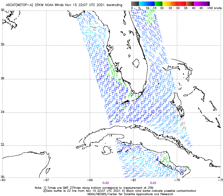
Edit: Also, looking at IR you can clearly see the low rotating over Florida and about half way through the state on its way to the Atlantic. Interestingly the intellicast future cast radar is still showing a system in the Gulf of Mexico tomorrow and it looks very tropical with a lot of twist. Does any Mets know what could cause that if the low is gone? Is it another low?
0 likes
Who is online
Users browsing this forum: cycloneye and 38 guests