ATL: DANNY - Remnants - Discussion
Moderator: S2k Moderators
-
HURRICANELONNY
- Category 5

- Posts: 1390
- Joined: Wed May 07, 2003 6:48 am
- Location: HOLLYWOOD.FL
How many times in the past did the NHC say slow strengthening only to dissipate. Not even close to an exact science but it's the best we got. Sal is beating it but still holding on. If there was shear and sal it would be toast by now. So if it could shake off some Sal maybe Danny has a chance. Just my thought. Not official. 
0 likes
hurricanelonny
-
lordkev
- Tropical Low

- Posts: 34
- Joined: Tue Sep 09, 2014 10:14 am
- Location: St Kitts, Lesser Antilles
Re: ATL: DANNY - Tropical Storm - Discussion
I mostly just lurk, but one thing I've noticed is that people love to bet against the NHC. From what I've seen, most of the time they lose that bet. 
0 likes
-
tatertawt24
- Category 1

- Posts: 309
- Joined: Wed Oct 24, 2012 12:57 pm
Oh wow, it looked to be in pretty bad shape that latest scan.  I guess it still has a shot but knowing the Atlantic...
0 likes
Personal Forecast Disclaimer:
The posts in this forum are NOT official forecast and should not be used as such. They are just the opinion of the poster and may or may not be backed by sound meteorological data. They are NOT endorsed by any professional institution or storm2k.org. For official information, please refer to the NHC and NWS products.
The posts in this forum are NOT official forecast and should not be used as such. They are just the opinion of the poster and may or may not be backed by sound meteorological data. They are NOT endorsed by any professional institution or storm2k.org. For official information, please refer to the NHC and NWS products.
Re: ATL: DANNY - Tropical Storm - Discussion
Frank2 wrote:Lots of dry air strato-cu and a tiny core - we've seen that before and often it does mean a weak system...
Actually it looks pretty good considering it is closing in on D-Min and is breaking away from the ITCZ.
0 likes
Re: ATL: DANNY - Tropical Storm - Discussion
tolakram wrote:Last year the GFS has real issues with not recognizing the dry conditions in the deep tropics. I'm starting to think this remains weak and south. Also note latest convective burst is done, can't seem to maintain convection.
Live loop: http://rammb.cira.colostate.edu/ramsdis/online/loop.asp?data_folder=tropical/tropical_ge_4km_visir2_floater_1&width=640&height=480&number_of_images_to_display=12
Personal Forecast Disclaimer:
The posts in this forum are NOT official forecast and should not be used as such. They are just the opinion of the poster and may or may not be backed by sound meteorological data. They are NOT endorsed by any professional institution or storm2k.org. For official information, please refer to the NHC and NWS products.
Actually I was more impressed by the anti-cyclone look of the cirrus. Dry air is at its worst when accompanied by shear that can penetrate the storms envelope.
0 likes

Re: ATL: DANNY - Tropical Storm - Discussion
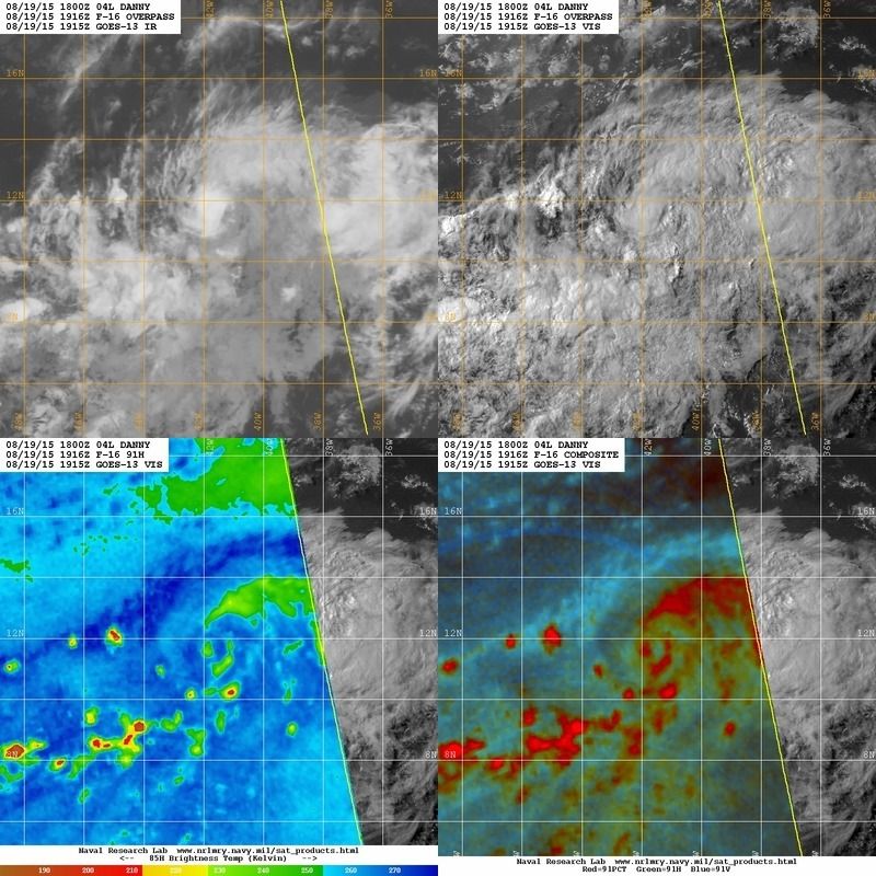
Hot off the press image, convection remains minimal close to it's core.

0 likes
-
HURRICANELONNY
- Category 5
- Posts: 1390
- Joined: Wed May 07, 2003 6:48 am
- Location: HOLLYWOOD.FL
Re:
HURRICANELONNY wrote:How many times in the past did the NHC say slow strengthening only to dissipate. Not even close to an exact science but it's the best we got. Sal is beating it but still holding on. If there was shear and sal it would be toast by now. So if it could shake off some Sal maybe Danny has a chance. Just my thought. Not official.
I hope I lose big time. But looking at sat. it doesn't look good right now.
0 likes
hurricanelonny

Outflow may be improving, the stationary high cloud line is being pushed back a bit by the outflow.
0 likes
The above post is not official and should not be used as such. It is the opinion of the poster and may or may not be backed by sound meteorological data. It is not endorsed by any professional institution or storm2k.org. For official information, please refer to the NHC and NWS products.
-
Blown Away

- S2K Supporter

- Posts: 10253
- Joined: Wed May 26, 2004 6:17 am
Re: ATL: DANNY - Tropical Storm - Discussion

0 likes
Hurricane Eye Experience: David 79, Irene 99, Frances 04, Jeanne 04, Wilma 05… Hurricane Brush Experience: Andrew 92, Erin 95, Floyd 99, Matthew 16, Irma 17, Ian 22, Nicole 22…
-
NCSTORMMAN

Re: ATL: DANNY - Tropical Storm - Discussion
xironman wrote:tolakram wrote:Last year the GFS has real issues with not recognizing the dry conditions in the deep tropics. I'm starting to think this remains weak and south. Also note latest convective burst is done, can't seem to maintain convection.
Live loop: http://rammb.cira.colostate.edu/ramsdis/online/loop.asp?data_folder=tropical/tropical_ge_4km_visir2_floater_1&width=640&height=480&number_of_images_to_display=12
Personal Forecast Disclaimer:
The posts in this forum are NOT official forecast and should not be used as such. They are just the opinion of the poster and may or may not be backed by sound meteorological data. They are NOT endorsed by any professional institution or storm2k.org. For official information, please refer to the NHC and NWS products.
Actually I was more impressed by the anti-cyclone look of the cirrus. Dry air is at its worst when accompanied by shear that can penetrate the storms envelope.
Xironman, I couldn't agree more. Looking at the upper Cirrus screaming to the SW, a couple hundred miles southeast of the storm... plus soon moving toward DMAX, and I'm thinking Danny is gonna take on a pretty impressive appearance later today/evening. I certainly cant ignore the obvious lack of convection and visible affects that ingested dryer air has had on convective banding to form, but I do think that for the near term we are going to see an increase in convection and an overall healthier appearance. Next few days will probably exhibit the tug of war between Danny remaining insulated under its protective upper high and drying out due to Saharan intrusion. Tonight/tomorrow might be where Danny reaches its peak (a bit sooner than NHC is presently projecting)
0 likes
Andy D
(For official information, please refer to the NHC and NWS products.)
(For official information, please refer to the NHC and NWS products.)
-
tatertawt24
- Category 1
- Posts: 309
- Joined: Wed Oct 24, 2012 12:57 pm
Re: ATL: DANNY - Tropical Storm - Discussion

Really messy.
0 likes
Personal Forecast Disclaimer:
The posts in this forum are NOT official forecast and should not be used as such. They are just the opinion of the poster and may or may not be backed by sound meteorological data. They are NOT endorsed by any professional institution or storm2k.org. For official information, please refer to the NHC and NWS products.
The posts in this forum are NOT official forecast and should not be used as such. They are just the opinion of the poster and may or may not be backed by sound meteorological data. They are NOT endorsed by any professional institution or storm2k.org. For official information, please refer to the NHC and NWS products.
-
ozonepete
- Professional-Met

- Posts: 4743
- Joined: Mon Sep 07, 2009 3:23 pm
- Location: From Ozone Park, NYC / Now in Brooklyn, NY
Re: ATL: DANNY - Tropical Storm - Discussion
Remember this is a very young tropical cyclone in the early stages of development. Even in the best conditions they pulse up and down and the convection pops up and dies down in various clusters around and/or over the center. The one negative, possible significant dry air entrainment at mid-levels, has not happened so far and isn't happening now. So there's no reason to pronounce it dead every time the convection wanes, especially during DMIN.
As far as what will happen as it nears the islands, to bet against the NHC this far out is to lose 99 out of 100 times.
As far as what will happen as it nears the islands, to bet against the NHC this far out is to lose 99 out of 100 times.
Last edited by ozonepete on Wed Aug 19, 2015 3:35 pm, edited 1 time in total.
0 likes
-
ozonepete
- Professional-Met
- Posts: 4743
- Joined: Mon Sep 07, 2009 3:23 pm
- Location: From Ozone Park, NYC / Now in Brooklyn, NY
Re: ATL: DANNY - Tropical Storm - Discussion
Btw, chaser1 and xironman, good discussion. You guys make storm2k look good!
0 likes
-
tatertawt24
- Category 1
- Posts: 309
- Joined: Wed Oct 24, 2012 12:57 pm
Re: ATL: DANNY - Tropical Storm - Discussion
ozonepete wrote:Remember this is a very young tropical cyclone in the early stages of development. Even in the best conditions they pulse up and down and the convection pops up and dies down in various clusters around and/or over the center. The one negative, possible dry air entrainment at mid-levels, has not happened so far and isn't happening now. So there's no reason to pronounce it dead every time the convection wanes, especially during DMIN.
As far as what will happen as it nears the islands, to bet against the NHC this far out is to lose 99 out of 100 times.
True -- the fear I have is that during these down cycles, he's going to enter a hostile environment and never be able to recover, since he got hit at a weak point.
0 likes
Personal Forecast Disclaimer:
The posts in this forum are NOT official forecast and should not be used as such. They are just the opinion of the poster and may or may not be backed by sound meteorological data. They are NOT endorsed by any professional institution or storm2k.org. For official information, please refer to the NHC and NWS products.
The posts in this forum are NOT official forecast and should not be used as such. They are just the opinion of the poster and may or may not be backed by sound meteorological data. They are NOT endorsed by any professional institution or storm2k.org. For official information, please refer to the NHC and NWS products.

Re: ATL: DANNY - Tropical Storm - Discussion
0 likes
Hurricane center mentions that the system is further embedded within the ITCZ, is this limiting convection by inhibiting convergence, on top of the dry air?
0 likes
The above post is not official and should not be used as such. It is the opinion of the poster and may or may not be backed by sound meteorological data. It is not endorsed by any professional institution or storm2k.org. For official information, please refer to the NHC and NWS products.
-
Gustywind

- Category 5
- Posts: 12334
- Joined: Mon Sep 03, 2007 7:29 am
- Location: Baie-Mahault, GUADELOUPE
000
WTNT34 KNHC 192032
TCPAT4
BULLETIN
TROPICAL STORM DANNY ADVISORY NUMBER 6
NWS NATIONAL HURRICANE CENTER MIAMI FL AL042015
500 PM AST WED AUG 19 2015
...DANNY MOVING MORE SLOWLY WESTWARD...
SUMMARY OF 500 PM AST...2100 UTC...INFORMATION
----------------------------------------------
LOCATION...11.5N 42.0W
ABOUT 1325 MI...2130 KM E OF THE LESSER ANTILLES
MAXIMUM SUSTAINED WINDS...50 MPH...85 KM/H
PRESENT MOVEMENT...W OR 280 DEGREES AT 10 MPH...17 KM/H
MINIMUM CENTRAL PRESSURE...1000 MB...29.53 INCHES
WATCHES AND WARNINGS
--------------------
There are no coastal watches or warnings in effect.
DISCUSSION AND 48-HOUR OUTLOOK
------------------------------
At 500 PM AST (2100 UTC), the center of Tropical Storm Danny was
located near latitude 11.5 North, longitude 42.0 West. Danny is
moving toward the west near 10 mph (17 km/h), and a west-
northwestward motion at a slightly slower forward speed is expected
during the next 48 hours.
Maximum sustained winds are near 50 mph (85 km/h) with higher gusts.
Some strengthening is forecast during the next 48 hours, and Danny
could still become a hurricane by Friday.
Tropical storm force winds extend outward up to 70 miles (110 km)
from the center.
The estimated minimum central pressure is 1000 mb (29.53 inches).
HAZARDS AFFECTING LAND
----------------------
None.
NEXT ADVISORY
-------------
Next complete advisory at 1100 PM AST.
$$
Forecaster Kimberlain
0 likes
-
NCSTORMMAN
Re: ATL: DANNY - Tropical Storm - Discussion
tatertawt24 wrote:
Really messy.
Resolution has a way of changing perspectives
http://www.ssd.noaa.gov/PS/TROP/floater ... -long.html
0 likes
Andy D
(For official information, please refer to the NHC and NWS products.)
(For official information, please refer to the NHC and NWS products.)
Who is online
Users browsing this forum: No registered users and 13 guests