ATL: DANNY - Remnants - Discussion

Moderator: S2k Moderators

Message
Author
User avatar
NDG
S2K Supporter
S2K Supporter
Posts: 15446
Joined: Sun Jul 09, 2006 10:14 pm
Location: Orlando, FL

Re:

#881 Postby NDG » Thu Aug 20, 2015 8:28 pm

NCSTORMMAN wrote:All I want to know is WHEN this storm makes it past bad conditions in the Caribbean what does it look like on the other side? Ideal? Okay? Bad? Also, I am talking opinion and model based stuff.


IMO, is anybody's guess right now, it could be really bad UL conditions or really good conditions and if it could stay away from land.
Is a small system so if it encounters really bad conditions it could really weaken into almost nothing.
0 likes   

User avatar
NDG
S2K Supporter
S2K Supporter
Posts: 15446
Joined: Sun Jul 09, 2006 10:14 pm
Location: Orlando, FL

Re: ATL: DANNY - Hurricane- Discussion

#882 Postby NDG » Thu Aug 20, 2015 8:34 pm

ozonepete wrote:
NDG wrote:
ozonepete wrote:
The NHC has been saying that the trough will weaken and lift out over the next 3 days. So maybe jello wall would be more accurate.


I am not talking about the mid level trough, I am talking about the "TUTT"
There's a walk of SW UL winds ahead of of Danny, the same SW windshear the NHC says Danny will encounter sabot approaches the islands.

Edit: and when the NHC talks about steering weaknesses they are referring to mid level troughs not TUTTs, IMO.


Yes I know the difference. But there is no classic TUTT out there right now. Read the latest NHC tropical Atlantic discussion. They always talk about the TUTT when there is one and they don't talk about it right now. A true TUTT extends from the north central Atlantic southwestward towards Florida and then eastward into the tropical central Atlantic. We don't currently have one.

Also, a strong upper level flow of winds at 300 or 200 mb often enhance a TC, not weaken it, because they enhance the upper outflow. Shear is measured through a layer, not just at one altitude. Thus shear we look for that can give a tropical cyclone a severe haircut is usually measured from 850 mb to 200mb or some other less thick layer depending on how "tall" the cyclone is. So a tropical cyclone in the Atlantic or Pacific often gets a strength boost as it first encounters a TUTT to its west. The SW winds initially remove air from the top of the storm and thus help the outflow.


Sorry Pete, but there is currently a TUTT.

Edit: TUTTs may help in cyclonic genesis but they may not help a strengthening tropical cyclone.

Image
Last edited by NDG on Thu Aug 20, 2015 8:37 pm, edited 1 time in total.
0 likes   

User avatar
northjaxpro
S2K Supporter
S2K Supporter
Posts: 8900
Joined: Mon Sep 27, 2010 11:21 am
Location: Jacksonville, FL

#883 Postby northjaxpro » Thu Aug 20, 2015 8:36 pm

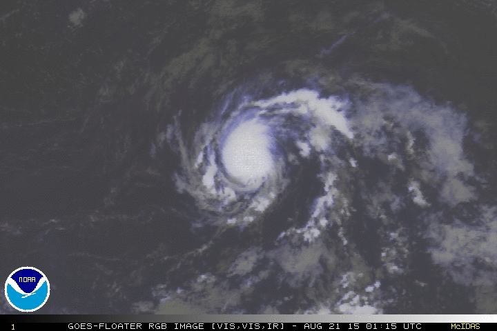
:uarrow: Looking at the Satellite loop above and following the forward motion of the eye, Danny is definitely moving west-northwest, definitely a more decided north of west the past several hours.
0 likes   
NEVER, EVER SAY NEVER in the tropics and weather in general, and most importantly, with life itself!!

________________________________________________________________________________________

Fay 2008 Beryl 2012 Debby 2012 Colin 2016 Hermine 2016 Julia 2016 Matthew 2016 Irma 2017 Dorian 2019

User avatar
gatorcane
S2K Supporter
S2K Supporter
Posts: 23691
Age: 47
Joined: Sun Mar 13, 2005 3:54 pm
Location: Boca Raton, FL

Re:

#884 Postby gatorcane » Thu Aug 20, 2015 8:40 pm

NCSTORMMAN wrote:All I want to know is WHEN this storm makes it past bad conditions in the Caribbean what does it look like on the other side? Ideal? Okay? Bad? Also, I am talking opinion and model based stuff.

If it makes it to the other side somehow and heads north of the Caribbean on a WNW path, it might find more favorable conditions. The current shear tendency chart is showing a large area of favorable upper-level winds north of the Caribbean. That area has been pretty favorable most of this hurricane season (and last year too).

Image
0 likes   

User avatar
Bocadude85
Category 5
Category 5
Posts: 2991
Age: 38
Joined: Mon Apr 18, 2005 2:20 pm
Location: Honolulu,Hi

Re: ATL: DANNY - Hurricane- Discussion

#885 Postby Bocadude85 » Thu Aug 20, 2015 8:48 pm

0 likes   

User avatar
galaxy401
Category 5
Category 5
Posts: 2419
Age: 30
Joined: Sat Aug 25, 2012 9:04 pm
Location: Casa Grande, Arizona

#886 Postby galaxy401 » Thu Aug 20, 2015 8:50 pm

I may have missed it but was the best track posted yet?
0 likes   
Got my eyes on moving right into Hurricane Alley: Florida.

User avatar
Hurricaneman
Category 5
Category 5
Posts: 7351
Age: 45
Joined: Tue Aug 31, 2004 3:24 pm
Location: central florida

Re: ATL: DANNY - Hurricane- Discussion

#887 Postby Hurricaneman » Thu Aug 20, 2015 8:51 pm

If this goes towards the northern part of the cone it may have low shear from 65W on westward which if there's something left could be of real concern

The posts in this forum are NOT official forecast and should not be used as such. They are just the opinion of the poster and may or may not be backed by sound meteorological data. They are NOT endorsed by any professional institution or storm2k.org. For official information, please refer to the NHC and NWS products
0 likes   

User avatar
northjaxpro
S2K Supporter
S2K Supporter
Posts: 8900
Joined: Mon Sep 27, 2010 11:21 am
Location: Jacksonville, FL

Re: ATL: DANNY - Hurricane- Discussion

#888 Postby northjaxpro » Thu Aug 20, 2015 8:54 pm

Bocadude85 wrote:Looks like the eye may be clearing out soon.

http://www.ssd.noaa.gov/PS/TROP/floaters/04L/imagery/avn_lalo-animated.gif


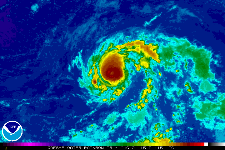
Yes, the eye is clearing out again. It sure looks impressive tonight and I am wondering if Danny is intensifying again right now?
Last edited by northjaxpro on Thu Aug 20, 2015 8:55 pm, edited 2 times in total.
0 likes   
NEVER, EVER SAY NEVER in the tropics and weather in general, and most importantly, with life itself!!

________________________________________________________________________________________

Fay 2008 Beryl 2012 Debby 2012 Colin 2016 Hermine 2016 Julia 2016 Matthew 2016 Irma 2017 Dorian 2019

ozonepete
Professional-Met
Professional-Met
Posts: 4743
Joined: Mon Sep 07, 2009 3:23 pm
Location: From Ozone Park, NYC / Now in Brooklyn, NY

Re: ATL: DANNY - Hurricane- Discussion

#889 Postby ozonepete » Thu Aug 20, 2015 8:54 pm

NDG wrote:
Sorry Pete, but there is currently a TUTT.

Edit: TUTTs may help in cyclonic genesis but they may not help a strengthening tropical cyclone.


You are right. There is a flattened, not very classic TUTT over the Caribbean and central America, but not one over the Atlantic where we are looking. TUTTS are famous for causing TC intensification as the TC first encounters it and the SW flow at 200mb causes evacuation of air over it. So they may not help but they also may help, but they don't kill a TC as the TC first encounters them. That was all I was sayin'. :)
Last edited by ozonepete on Thu Aug 20, 2015 8:56 pm, edited 2 times in total.
0 likes   

NCSTORMMAN

Re: ATL: DANNY - Hurricane- Discussion

#890 Postby NCSTORMMAN » Thu Aug 20, 2015 8:55 pm

northjaxpro wrote:
Bocadude85 wrote:Looks like the eye may be clearing out soon.

http://www.ssd.noaa.gov/PS/TROP/floaters/04L/imagery/avn_lalo-animated.gif


Yes, the eye is clearing out again. It sure looks impressive tonight and I am wondering if Danny is intensifying sgain rihht now?


It was stronger than 80 MPH last advisory in my opinion and it is stronger now. NHC underestimating the storm in my opinion. I am no expert or MET though.
0 likes   

User avatar
Bocadude85
Category 5
Category 5
Posts: 2991
Age: 38
Joined: Mon Apr 18, 2005 2:20 pm
Location: Honolulu,Hi

Re: ATL: DANNY - Hurricane- Discussion

#891 Postby Bocadude85 » Thu Aug 20, 2015 8:57 pm

northjaxpro wrote:
Bocadude85 wrote:Looks like the eye may be clearing out soon.

http://www.ssd.noaa.gov/PS/TROP/floaters/04L/imagery/avn_lalo-animated.gif


Yes, the eye is clearing out again. It sure looks impressive tonight and I am wondering if Danny is intensifying again right now?


Definitely looks to be strengthening again. The CDO looks nice and symmetrical. I'd say 75-80kts now.
0 likes   

User avatar
gatorcane
S2K Supporter
S2K Supporter
Posts: 23691
Age: 47
Joined: Sun Mar 13, 2005 3:54 pm
Location: Boca Raton, FL

Re: ATL: DANNY - Hurricane- Discussion

#892 Postby gatorcane » Thu Aug 20, 2015 8:58 pm

ozonepete wrote:
NDG wrote:
Sorry Pete, but there is currently a TUTT.

Edit: TUTTs may help in cyclonic genesis but they may not help a strengthening tropical cyclone.


You are right. There is a flattened, not very classic TUTT over the Caribbean and central America, but not one over the Atlantic where we are looking. TUTTS are famous for causing TC intensification as the TC first encounters it and the SW flow at 200mb causes evacuation of air over it. So they may not help but they also may help, but they don't kill a TC as the TC first encounters them. That was all I was sayin'. :)


The 18Z GFS simulated satellite shows Danny's convection coverage expands as it encounters the flattened TUTT:

Image
0 likes   

ozonepete
Professional-Met
Professional-Met
Posts: 4743
Joined: Mon Sep 07, 2009 3:23 pm
Location: From Ozone Park, NYC / Now in Brooklyn, NY

Re: ATL: DANNY - Hurricane- Discussion

#893 Postby ozonepete » Thu Aug 20, 2015 9:02 pm

It's becoming very symmetrical with a nice circular core formation. Almost always a sign of strengthening.
0 likes   

User avatar
bahamaswx
Category 5
Category 5
Posts: 1542
Joined: Sat Sep 13, 2003 1:11 am
Location: Georgetown, Bahamas

#894 Postby bahamaswx » Thu Aug 20, 2015 9:03 pm

If he clears out that eye again I'd have a lot of trouble believing it's only a minimal cat 1.
0 likes   

User avatar
gatorcane
S2K Supporter
S2K Supporter
Posts: 23691
Age: 47
Joined: Sun Mar 13, 2005 3:54 pm
Location: Boca Raton, FL

Re:

#895 Postby gatorcane » Thu Aug 20, 2015 9:05 pm

bahamaswx wrote:If he clears out that eye again I'd have a lot of trouble believing it's only a minimal cat 1.


I agree, it looks like it could be stronger than a CAT 1 the way it looks on IR SAT imagery tonight.
0 likes   

wjs3
S2K Supporter
S2K Supporter
Posts: 633
Joined: Sat Aug 14, 2004 7:57 am

Re: ATL: DANNY - Hurricane- Discussion

#896 Postby wjs3 » Thu Aug 20, 2015 9:05 pm

ozonepete wrote:
NDG wrote:
Sorry Pete, but there is currently a TUTT.

Edit: TUTTs may help in cyclonic genesis but they may not help a strengthening tropical cyclone.


You are right. There is a flattened, not very classic TUTT over the Caribbean and central America, but not one over the Atlantic where we are looking. TUTTS are famous for causing TC intensification as the TC first encounters it and the SW flow at 200mb causes evacuation of air over it. So they may not help but they also may help, but they don't kill a TC as the TC first encounters them. That was all I was sayin'. :)


For anyone who might be reading who is new to TUTTs:

https://www.e-education.psu.edu/worldof ... /node/2067

Pete's right. That's not what you would call a classic TUTT.
0 likes   

ozonepete
Professional-Met
Professional-Met
Posts: 4743
Joined: Mon Sep 07, 2009 3:23 pm
Location: From Ozone Park, NYC / Now in Brooklyn, NY

Re: ATL: DANNY - Hurricane- Discussion

#897 Postby ozonepete » Thu Aug 20, 2015 9:06 pm

Nice..

Image

Image
0 likes   

User avatar
northjaxpro
S2K Supporter
S2K Supporter
Posts: 8900
Joined: Mon Sep 27, 2010 11:21 am
Location: Jacksonville, FL

#898 Postby northjaxpro » Thu Aug 20, 2015 9:07 pm

Yeah, I would give it at least about 75 kts right now. I do think Danny is strengthening again with the eye clearing out and the more symmetric structure of the inner core and the deep convection within it. It is the best appearance overall of Danny to this juncture in my opinion.
Last edited by northjaxpro on Thu Aug 20, 2015 9:10 pm, edited 1 time in total.
0 likes   
NEVER, EVER SAY NEVER in the tropics and weather in general, and most importantly, with life itself!!

________________________________________________________________________________________

Fay 2008 Beryl 2012 Debby 2012 Colin 2016 Hermine 2016 Julia 2016 Matthew 2016 Irma 2017 Dorian 2019

tolakram
Admin
Admin
Posts: 20009
Age: 62
Joined: Sun Aug 27, 2006 8:23 pm
Location: Florence, KY (name is Mark)

Re: ATL: DANNY - Hurricane- Discussion

#899 Postby tolakram » Thu Aug 20, 2015 9:10 pm

0 likes   
M a r k
- - - - -
Join us in chat: Storm2K Chatroom Invite. Android and IOS apps also available.

The posts in this forum are NOT official forecasts and should not be used as such. Posts are NOT endorsed by any professional institution or STORM2K.org. For official information and forecasts, please refer to NHC and NWS products.

User avatar
NDG
S2K Supporter
S2K Supporter
Posts: 15446
Joined: Sun Jul 09, 2006 10:14 pm
Location: Orlando, FL

Re: ATL: DANNY - Hurricane- Discussion

#900 Postby NDG » Thu Aug 20, 2015 9:13 pm

ozonepete wrote:
NDG wrote:
Sorry Pete, but there is currently a TUTT.

Edit: TUTTs may help in cyclonic genesis but they may not help a strengthening tropical cyclone.


You are right. There is a flattened, not very classic TUTT over the Caribbean and central America, but not one over the Atlantic where we are looking. TUTTS are famous for causing TC intensification as the TC first encounters it and the SW flow at 200mb causes evacuation of air over it. So they may not help but they also may help, but they don't kill a TC as the TC first encounters them. That was all I was sayin'. :)


Yeah, I have seen TUTTs make TWs come to live when they enter the eastern Caribbean. In this case I am thinking that originally Danny may weaken some as it gets closer to the islands due to the windshear but the same windshear may expand its convection coverage, or at least lets hope so that it can bring some relief to the Islands.
0 likes   


Return to “2015”

Who is online

Users browsing this forum: No registered users and 4 guests