ATL: DANNY - Remnants - Discussion

Moderator: S2k Moderators

Message
Author
User avatar
Hurricaneman
Category 5
Category 5
Posts: 7351
Age: 45
Joined: Tue Aug 31, 2004 3:24 pm
Location: central florida

Re: Re:

#921 Postby Hurricaneman » Thu Aug 20, 2015 10:04 pm

Steve wrote:
Miami Storm Tracker wrote:I am by no means a met, but Danny looks really good tonight. in fact better than he has since it was classified, I think it has to be more than a minimal Cat 1 based only by appearance.


Agreed. Not sure if it is the final peak, but danny is rolling for the time being and should easily be at it's strongest yet if not ever based on what happens next 36 hours. But yeah. You are right. Also notice the eye is pretty far south in the convective mass.

http://www.ssd.noaa.gov/PS/TROP/floater ... oater.html


looks like the eye is in the middle to me but I could be wrong

The posts in this forum are NOT official forecast and should not be used as such. They are just the opinion of the poster and may or may not be backed by sound meteorological data. They are NOT endorsed by any professional institution or storm2k.org. For official information, please refer to the NHC and NWS products
0 likes   

User avatar
Miami Storm Tracker
Category 4
Category 4
Posts: 910
Age: 67
Joined: Sun Jun 13, 2010 10:12 pm
Location: Key Largo, Fla.
Contact:

#922 Postby Miami Storm Tracker » Thu Aug 20, 2015 10:06 pm

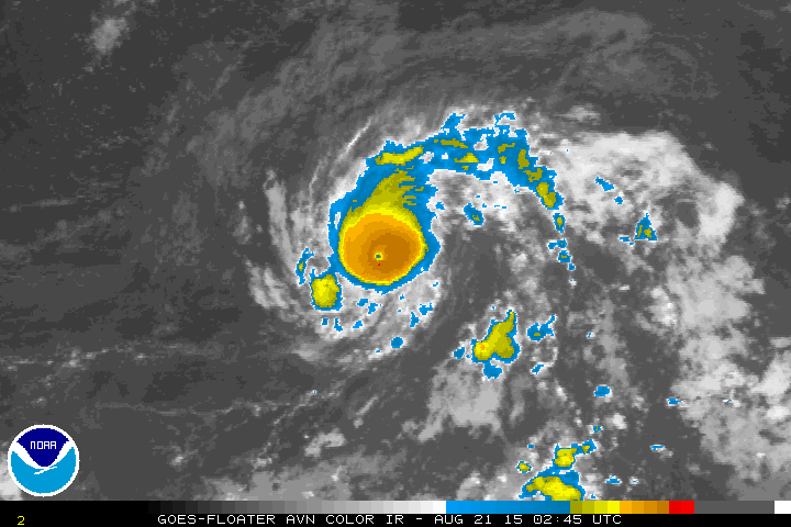
Looks great on the AVN very clear pin hole eye.
0 likes   

User avatar
Yellow Evan
Professional-Met
Professional-Met
Posts: 16143
Age: 27
Joined: Fri Jul 15, 2011 12:48 pm
Location: Henderson, Nevada/Honolulu, HI
Contact:

#923 Postby Yellow Evan » Thu Aug 20, 2015 10:08 pm

I'd go with 80 knots.
0 likes   

User avatar
Bocadude85
Category 5
Category 5
Posts: 2991
Age: 38
Joined: Mon Apr 18, 2005 2:20 pm
Location: Honolulu,Hi

Re:

#924 Postby Bocadude85 » Thu Aug 20, 2015 10:09 pm

Miami Storm Tracker wrote:Looks great on the AVN very clear pin hole eye.


Check Danny out on RBTOP

http://www.ssd.noaa.gov/PS/TROP/floaters/04L/imagery/rbtop_lalo-animated.gif
0 likes   

User avatar
northjaxpro
S2K Supporter
S2K Supporter
Posts: 8900
Joined: Mon Sep 27, 2010 11:21 am
Location: Jacksonville, FL

#925 Postby northjaxpro » Thu Aug 20, 2015 10:10 pm

Great to see you in here tonight ozonepete. I have not spoke to you in awhile. Yeah great discussion with NDG, my fellow pal on the Storm2K forums. It is always
great to have great dialogue on the board.
0 likes   
NEVER, EVER SAY NEVER in the tropics and weather in general, and most importantly, with life itself!!

________________________________________________________________________________________

Fay 2008 Beryl 2012 Debby 2012 Colin 2016 Hermine 2016 Julia 2016 Matthew 2016 Irma 2017 Dorian 2019

User avatar
N2FSU
S2K Supporter
S2K Supporter
Posts: 1062
Joined: Thu Sep 04, 2003 2:04 pm
Location: Tallahassee, FL

Re: ATL: DANNY - Hurricane- Discussion

#926 Postby N2FSU » Thu Aug 20, 2015 10:15 pm

Looking good:

Image
0 likes   

User avatar
Miami Storm Tracker
Category 4
Category 4
Posts: 910
Age: 67
Joined: Sun Jun 13, 2010 10:12 pm
Location: Key Largo, Fla.
Contact:

#927 Postby Miami Storm Tracker » Thu Aug 20, 2015 10:18 pm

It is amazing what weathermen will say, had Channel 7 news on while checking Storm2K. won't mention names but he just said before a break Danny was not looking that impressive. Not sure what he is looking at to be able to say that.
0 likes   

User avatar
northjaxpro
S2K Supporter
S2K Supporter
Posts: 8900
Joined: Mon Sep 27, 2010 11:21 am
Location: Jacksonville, FL

#928 Postby northjaxpro » Thu Aug 20, 2015 10:20 pm

Beautifiul pinhole eye showing with Danny. In my educated opinion and analysis given the current satellite presentation, this is a Cat 2 tropical cyclone which is still strengthening.
0 likes   
NEVER, EVER SAY NEVER in the tropics and weather in general, and most importantly, with life itself!!

________________________________________________________________________________________

Fay 2008 Beryl 2012 Debby 2012 Colin 2016 Hermine 2016 Julia 2016 Matthew 2016 Irma 2017 Dorian 2019

User avatar
Miami Storm Tracker
Category 4
Category 4
Posts: 910
Age: 67
Joined: Sun Jun 13, 2010 10:12 pm
Location: Key Largo, Fla.
Contact:

Re: ATL: DANNY - Hurricane- Discussion

#929 Postby Miami Storm Tracker » Thu Aug 20, 2015 10:21 pm

Could not agree with you more.
0 likes   

User avatar
Hurricaneman
Category 5
Category 5
Posts: 7351
Age: 45
Joined: Tue Aug 31, 2004 3:24 pm
Location: central florida

#930 Postby Hurricaneman » Thu Aug 20, 2015 10:24 pm

I can safely say this is the best MDR system since Katia in 2011 so basically in 4 years

The posts in this forum are NOT official forecast and should not be used as such. They are just the opinion of the poster and may or may not be backed by sound meteorological data. They are NOT endorsed by any professional institution or storm2k.org. For official information, please refer to the NHC and NWS products
0 likes   

floridasun78
Category 5
Category 5
Posts: 3755
Joined: Sun May 17, 2009 10:16 pm
Location: miami fl

Re:

#931 Postby floridasun78 » Thu Aug 20, 2015 10:26 pm

Miami Storm Tracker wrote:It is amazing what weathermen will say, had Channel 7 news on while checking Storm2K. won't mention names but he just said before a break Danny was not looking that impressive. Not sure what he is looking at to be able to say that.

i like Craig Setzer better i meet him person as i am member of weather watcher
0 likes   

User avatar
Bocadude85
Category 5
Category 5
Posts: 2991
Age: 38
Joined: Mon Apr 18, 2005 2:20 pm
Location: Honolulu,Hi

Re:

#932 Postby Bocadude85 » Thu Aug 20, 2015 10:26 pm

northjaxpro wrote:Beautifiul pinhole eye showing with Danny. In my educated opinion and analysis given the current satellite presentation, this is a Cat 2 tropical cyclone which is still strengthening.


I couldnt agree more. The sat presentation continues to improve.
0 likes   

User avatar
drezee
S2K Supporter
S2K Supporter
Posts: 3664
Joined: Mon Jun 09, 2003 12:49 pm
Location: FL

Re: Re:

#933 Postby drezee » Thu Aug 20, 2015 10:27 pm

drezee wrote:
drezee wrote:We will get a better feel for his Northern wind field shortly. The closest thing we have to recon is below:

http://www.ndbc.noaa.gov/station_page.php?station=41041


Wind gust to 25.3Kts last hour...center should pass between 60-70nm at its closest approach tonight...should be on the border of the TS winds... it should also happen right about the time for the 11pm advisory


So small: center passed 63nm from buoy and highest gust was like 30mph
0 likes   

ozonepete
Professional-Met
Professional-Met
Posts: 4743
Joined: Mon Sep 07, 2009 3:23 pm
Location: From Ozone Park, NYC / Now in Brooklyn, NY

Re:

#934 Postby ozonepete » Thu Aug 20, 2015 10:32 pm

northjaxpro wrote:Great to see you in here tonight ozonepete. I have not spoke to you in awhile. Yeah great discussion with NDG, my fellow pal on the Storm2K forums. It is always great to have great dialogue on the board.


As always my friend, it is great to see you around for another season. And thanks for saying that about the discussion. Knowledge is only gained through sharing and sometimes we share through an intense dialogue. :)
0 likes   

User avatar
northjaxpro
S2K Supporter
S2K Supporter
Posts: 8900
Joined: Mon Sep 27, 2010 11:21 am
Location: Jacksonville, FL

#935 Postby northjaxpro » Thu Aug 20, 2015 10:33 pm

Yeah, Danny is very small. TS force winds probably only extend out only 40-50 miles from the eye and hurricane force winds probably only 20 -30 miles at best. Danny is a tiny hurricane, but man he has an extremely impressive and compact inner core currently.
0 likes   
NEVER, EVER SAY NEVER in the tropics and weather in general, and most importantly, with life itself!!

________________________________________________________________________________________

Fay 2008 Beryl 2012 Debby 2012 Colin 2016 Hermine 2016 Julia 2016 Matthew 2016 Irma 2017 Dorian 2019

User avatar
Ivanhater
Storm2k Moderator
Storm2k Moderator
Posts: 11161
Age: 38
Joined: Fri Jul 01, 2005 8:25 am
Location: Pensacola

Re: ATL: DANNY - Hurricane- Discussion

#936 Postby Ivanhater » Thu Aug 20, 2015 10:35 pm

Wow. Such a small and tenacious storm...Danny did it
0 likes   
Michael

ozonepete
Professional-Met
Professional-Met
Posts: 4743
Joined: Mon Sep 07, 2009 3:23 pm
Location: From Ozone Park, NYC / Now in Brooklyn, NY

Re: ATL: DANNY - Hurricane- Discussion

#937 Postby ozonepete » Thu Aug 20, 2015 10:39 pm

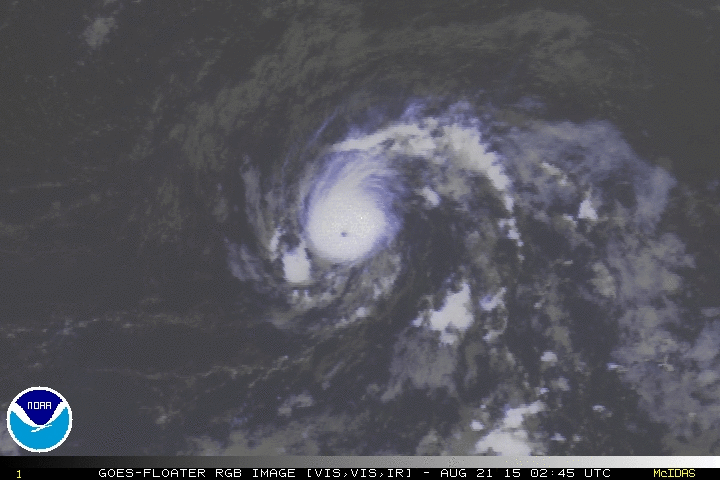
Wow, this is looking very impressive. The overall symmetry, pinhole eye, banding features and even the outflow are all organizing at the same time.

Image

Image
0 likes   

User avatar
Siker
Category 4
Category 4
Posts: 904
Age: 28
Joined: Thu Oct 25, 2012 7:36 pm
Location: Miami, FL

Re: ATL: DANNY - Hurricane- Discussion

#938 Postby Siker » Thu Aug 20, 2015 10:42 pm

ozonepete wrote:Wow, this is looking very impressive. The overall symmetry, pinhole eye, banding features and even the outflow are all organizing at the same time.


Care to share an intensity estimate?
0 likes   

User avatar
Bocadude85
Category 5
Category 5
Posts: 2991
Age: 38
Joined: Mon Apr 18, 2005 2:20 pm
Location: Honolulu,Hi

Re: ATL: DANNY - Hurricane- Discussion

#939 Postby Bocadude85 » Thu Aug 20, 2015 10:43 pm

Danny is really strengthening tonight. Look at the reds showing up on the avn.

http://www.ssd.noaa.gov/PS/TROP/floaters/04L/imagery/avn_lalo-animated.gif
0 likes   

User avatar
bahamaswx
Category 5
Category 5
Posts: 1542
Joined: Sat Sep 13, 2003 1:11 am
Location: Georgetown, Bahamas

#940 Postby bahamaswx » Thu Aug 20, 2015 10:43 pm

NHC must be looking at a totally different storm. 80mph? Yeah right.
0 likes   


Return to “2015”

Who is online

Users browsing this forum: No registered users and 13 guests