ATL: DANNY - Remnants - Discussion

Moderator: S2k Moderators

Message
Author
User avatar
SouthDadeFish
Professional-Met
Professional-Met
Posts: 2835
Joined: Thu Sep 23, 2010 2:54 pm
Location: Miami, FL
Contact:

Re: ATL: DANNY - Hurricane- Discussion

#1021 Postby SouthDadeFish » Fri Aug 21, 2015 7:47 am

cycloneye wrote:Only 85kts??

AL, 04, 2015082112, , BEST, 0, 138N, 478W, 85, 980, HU


NHC is most likely playing it safe until recon shows up. Easier for them to say, wow this small TC is stronger than we thought and bump it up, than go with 105 knots and recon only finds a 85-90 knot TC.

They gotta stick with the intensity estimates of what they have, which is basically just Dvorak at this point.
0 likes   

User avatar
Gustywind
Category 5
Category 5
Posts: 12334
Joined: Mon Sep 03, 2007 7:29 am
Location: Baie-Mahault, GUADELOUPE

#1022 Postby Gustywind » Fri Aug 21, 2015 7:52 am

Here is the Dvorak scale for those who are interrested...

:rarrow: http://www.ssd.noaa.gov/PS/TROP/CI-chart.html


Dvorak Current Intensity Chart


CI MWS MWS MSLP MSLP Saffir-Simpson
Number (Knots) (MPH) (Atlantic) (NW Pacific) Category
1 25 KTS 29 MPH (Approximate)
1.5 25 KTS 29 MPH
2 30 KTS 35 MPH 1009 mb 1000 mb
2.5 35 KTS 40 MPH 1005 mb 997 mb
3 45 KTS 52 MPH 1000 mb 991 mb
3.5 55 KTS 63 MPH 994 mb 984 mb
4 65 KTS 75 MPH 987 mb 976 mb 1 (64-83 KTS)
4.5 77 KTS 89 MPH 979 mb 966 mb 1 (64-83 KTS); 2 (84-96 KTS)
5 90 KTS 104 MPH 970 mb 954 mb 2 (84-96 KTS); 3 (97-113 KTS)
5.5 102 KTS 117 MPH 960 mb 941 mb 3 (97-113 KTS)
6 115 KTS 132 MPH 948 mb 927 mb 4 (114-135 KTS)
6.5 127 KTS 146 MPH 935 mb 914 mb 4 (114-135 KTS)
7 140 KTS 161 MPH 921 mb 898 mb 5 (136+ KTS)
7.5 155 KTS 178 MPH 906 mb 879 mb 5 (136+ KTS)
8 170 KTS 196 MPH 890 mb 858 mb 5 (136+ KTS)


CI -- Current Intensity
MWS -- Mean Wind Speed
MSLP -- Mean Sea Level Atmospheric Pressure in Millibars
0 likes   

User avatar
Hyperstorm
Category 5
Category 5
Posts: 1500
Joined: Sun Sep 07, 2003 3:48 am
Location: Ocala, FL

Re: ATL: DANNY - Hurricane- Discussion

#1023 Postby Hyperstorm » Fri Aug 21, 2015 7:55 am

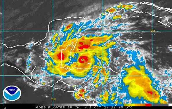
Comparison to Category 4 Hurricane Iris in 2001:

Image

The clouds are cooler with Iris, thus making it a Category 4. But thee size, structure and pinhole eye of Danny is very similar

Should at least support category 2-3 at this time...
Last edited by Hyperstorm on Fri Aug 21, 2015 7:57 am, edited 1 time in total.
0 likes   

User avatar
blp
Category 5
Category 5
Posts: 2840
Age: 46
Joined: Thu Sep 09, 2004 7:51 pm
Location: Miami, FL
Contact:

Re: ATL: DANNY - Hurricane- Discussion

#1024 Postby blp » Fri Aug 21, 2015 7:56 am

Danny is competing with Iris 2001 for smallest Hurricane. Iris had a 7nmi eye and reached Cat 4. Marco of 08 is smallest but was only a TS.
0 likes   
The following post is NOT an official forecast and should not be used as such. It is just the opinion of the poster and may or may not be backed by sound meteorological data. It is NOT endorsed by any professional institution including storm2k.org For Official Information please refer to the NHC and NWS products.

TheStormExpert

Re: Re:

#1025 Postby TheStormExpert » Fri Aug 21, 2015 8:00 am

SouthDadeFish wrote:
TheStormExpert wrote:Exactly how long from now until the wall of shear takes it down?


97,203 seconds from this post.

All joking aside, SHIPS shows the shear starting to increase around 06Z tomorrow, so overnight tonight into tomorrow morning.

Ok, thanks! :lol:
0 likes   

User avatar
Hyperstorm
Category 5
Category 5
Posts: 1500
Joined: Sun Sep 07, 2003 3:48 am
Location: Ocala, FL

Re: ATL: DANNY - Hurricane- Discussion

#1026 Postby Hyperstorm » Fri Aug 21, 2015 8:03 am

12z guidance has initialized at 100 mph. Seems stronger than that. 105-110mph is my personal estimate.
0 likes   

adam0983

Re: ATL: DANNY - Hurricane- Discussion

#1027 Postby adam0983 » Fri Aug 21, 2015 8:06 am

Does anyone see Hurricane Danny affecting Florida or the United States. The size of Danny reminds me of Andrew very small storms can fire up real fast in hostile enviroments. Just an Opinion not a forecast.
0 likes   

tolakram
Admin
Admin
Posts: 20009
Age: 62
Joined: Sun Aug 27, 2006 8:23 pm
Location: Florence, KY (name is Mark)

Re: ATL: DANNY - Hurricane- Discussion

#1028 Postby tolakram » Fri Aug 21, 2015 8:12 am

0 likes   
M a r k
- - - - -
Join us in chat: Storm2K Chatroom Invite. Android and IOS apps also available.

The posts in this forum are NOT official forecasts and should not be used as such. Posts are NOT endorsed by any professional institution or STORM2K.org. For official information and forecasts, please refer to NHC and NWS products.

User avatar
ronjon
Category 5
Category 5
Posts: 4822
Joined: Fri Aug 19, 2005 5:17 pm
Location: Hernando Beach, FL

Re: ATL: DANNY - Hurricane- Discussion

#1029 Postby ronjon » Fri Aug 21, 2015 8:17 am

That's a text book looking classic hurricane there.
0 likes   

Nederlander
S2K Supporter
S2K Supporter
Posts: 1250
Joined: Sat Jul 19, 2008 4:28 pm
Location: Conroe, TX

Re: ATL: DANNY - Hurricane- Discussion

#1030 Postby Nederlander » Fri Aug 21, 2015 8:32 am

blp wrote:Danny is competing with Iris 2001 for smallest Hurricane. Iris had a 7nmi eye and reached Cat 4. Marco of 08 is smallest but was only a TS.


How does Danny compare to Humberto?
0 likes   

User avatar
Gustywind
Category 5
Category 5
Posts: 12334
Joined: Mon Sep 03, 2007 7:29 am
Location: Baie-Mahault, GUADELOUPE

#1031 Postby Gustywind » Fri Aug 21, 2015 8:32 am

Waouw that's surprising, Danny is getting stronger and stronger since this morning. Looks like intensity is much higher than what NHC was predicting today. Sat presentation is pretty impressive given my untrained eyes. Islanders in the EC let's continue to monitor closely the situation.

By the way ouragans, what do you think about Danny?
0 likes   

wjs3
S2K Supporter
S2K Supporter
Posts: 633
Joined: Sat Aug 14, 2004 7:57 am

Re: ATL: DANNY - Hurricane- Discussion

#1032 Postby wjs3 » Fri Aug 21, 2015 8:35 am

wxman57 wrote:
NDG wrote:I really doubt that Danny is only at 85 mph winds, it's eyewall only looks like is like 20-30 miles in diameter, incredible!


I am measuring it's eye at 6nm in diameter. Radius of max winds is only 12-15nm. Probably over 100 kts, maybe 110 kts now.


Agreed. Wonder if we will get another "special" T number from the NHC at 11 rather than using the TAFB/SAB numbers that seem to have been struggling to handle this storm.
0 likes   

tolakram
Admin
Admin
Posts: 20009
Age: 62
Joined: Sun Aug 27, 2006 8:23 pm
Location: Florence, KY (name is Mark)

#1033 Postby tolakram » Fri Aug 21, 2015 8:36 am

According to the latest shear analysis Danny is close to the shear wall and, I'm guessing, is probably being vented by it at this point.

Image
0 likes   
M a r k
- - - - -
Join us in chat: Storm2K Chatroom Invite. Android and IOS apps also available.

The posts in this forum are NOT official forecasts and should not be used as such. Posts are NOT endorsed by any professional institution or STORM2K.org. For official information and forecasts, please refer to NHC and NWS products.

tolakram
Admin
Admin
Posts: 20009
Age: 62
Joined: Sun Aug 27, 2006 8:23 pm
Location: Florence, KY (name is Mark)

Re: ATL: DANNY - Hurricane- Discussion

#1034 Postby tolakram » Fri Aug 21, 2015 8:38 am

Image
0 likes   
M a r k
- - - - -
Join us in chat: Storm2K Chatroom Invite. Android and IOS apps also available.

The posts in this forum are NOT official forecasts and should not be used as such. Posts are NOT endorsed by any professional institution or STORM2K.org. For official information and forecasts, please refer to NHC and NWS products.

tolakram
Admin
Admin
Posts: 20009
Age: 62
Joined: Sun Aug 27, 2006 8:23 pm
Location: Florence, KY (name is Mark)

Re: ATL: DANNY - Hurricane- Discussion

#1035 Postby tolakram » Fri Aug 21, 2015 8:43 am

13:15Z

Image
0 likes   
M a r k
- - - - -
Join us in chat: Storm2K Chatroom Invite. Android and IOS apps also available.

The posts in this forum are NOT official forecasts and should not be used as such. Posts are NOT endorsed by any professional institution or STORM2K.org. For official information and forecasts, please refer to NHC and NWS products.

User avatar
gatorcane
S2K Supporter
S2K Supporter
Posts: 23691
Age: 47
Joined: Sun Mar 13, 2005 3:54 pm
Location: Boca Raton, FL

#1036 Postby gatorcane » Fri Aug 21, 2015 8:48 am

very impressive hurricane, seems to have grown is size some overnight too - it's been years since we have had one like this deep in the MDR.

to other comments - we have a long way to go with intensity forecasts that is for sure.
Last edited by gatorcane on Fri Aug 21, 2015 8:49 am, edited 2 times in total.
0 likes   

Florida1118

Re: ATL: DANNY - Hurricane- Discussion

#1037 Postby Florida1118 » Fri Aug 21, 2015 8:48 am

Danny's got a wall of shear, dry air, and a chain of mountainous islands to contend with. It'll definitely be tough to live with those factors.

Image

Dry Air is pretty abundant...though on the other side of the TUTT, shear seems to relax.

Personal Forecast Disclaimer:
The posts in this forum are NOT official forecast and should not be used as such. They are just the opinion of the poster and may or may not be backed by sound meteorological data. They are NOT endorsed by any professional institution or storm2k.org. For official information, please refer to the NHC and NWS products.
0 likes   

Frank2
Category 5
Category 5
Posts: 4061
Joined: Mon Jul 25, 2005 12:47 pm

#1038 Postby Frank2 » Fri Aug 21, 2015 8:49 am

We may see a complete transformation today, from a classic hurricane this morning, to a sheared system later today...

We shall see, but it's near the end of it's low shear environment...

It's ironic, Gatorcane, because just the other day I was talking with one of my old friends at the HRD, and we agreed that it seems to be years since the days of the classic Atlantic waves...

P.S. NOAA/HRD might arrive after the system has begun to weaken...
Last edited by Frank2 on Fri Aug 21, 2015 8:52 am, edited 1 time in total.
0 likes   

User avatar
drezee
S2K Supporter
S2K Supporter
Posts: 3664
Joined: Mon Jun 09, 2003 12:49 pm
Location: FL

#1039 Postby drezee » Fri Aug 21, 2015 8:52 am

Danny is in the entrance quad of the jet...so he should strengthen...probably have a good 12-18 hours more of this, then...The NOAA plane should get there before the demise....mini-stadium effect in the eye...smallest version I have EVER seen
0 likes   

Florida1118

Re:

#1040 Postby Florida1118 » Fri Aug 21, 2015 8:53 am

Frank2 wrote:We may see a complete transformation today, from a classic hurricane this morning, to a sheared system later today...

We shall see, but it's near the end of it's low shear environment...

It's ironic, Gatorcane, because just the other day I was talking with one of my old friends at the HRD, and we agreed that it seems to be years since the days of the classic Atlantic waves...


Too bad Recon won't be going out until later. Would have been great to get some data on him before he hits the wall.
0 likes   


Return to “2015”

Who is online

Users browsing this forum: No registered users and 11 guests