ATL: DANNY - Remnants - Discussion
Moderator: S2k Moderators
-
TheStormExpert
Well we finally got our first major hurricane and in a location of the basin where we'd least expect it due to such unfavorable conditions overall for the past several seasons. IMO this little mighty guy alone has bought excitement and surprises to a season that we barely even expected a TS to form in the MDR!
0 likes
-
ozonepete
- Professional-Met

- Posts: 4743
- Joined: Mon Sep 07, 2009 3:23 pm
- Location: From Ozone Park, NYC / Now in Brooklyn, NY
Re: ATL: DANNY - Hurricane- Discussion
SouthFLTropics wrote:panamatropicwatch wrote:SFLcane wrote:Canadian...
Whoa, does that mean Florida is going to have a north easter
That's a massive trough for this time of year. It looks like October.

That's a shear forecast, not upper air forecast for one level. At 500 mb and 300 mb it shows a very weak anemic trough over the east coast.
0 likes
-
ozonepete
- Professional-Met
- Posts: 4743
- Joined: Mon Sep 07, 2009 3:23 pm
- Location: From Ozone Park, NYC / Now in Brooklyn, NY
Re:
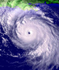
NCSTORMMAN wrote:Danny looks to be weakening right now. Everyone else see that latest image? Eye is well to the south of convection.
It is undergoing an Eyewall Replacement Cycle where a new eyewall (closed ring of tall thunderstorms) develops around the original eye. The original eye then shrinks as the new outer eye closes in on it. So for a small period as the original eye collapses there is no eye but as soon as the new outer eye gets established the air inside it clears out and voila, you have a new, bigger eye again. OK?
0 likes


Re: Re:
ozonepete wrote:NCSTORMMAN wrote:Danny looks to be weakening right now. Everyone else see that latest image? Eye is well to the south of convection.
It is undergoing an Eyewall Replacement Cycle where a new eyewall (closed ring of tall thunderstorms) develops around the original eye. The original eye then shrinks as the new outer eye closes in on it. So for a small period as the original eye collapses there is no eye but as soon as the new outer eye gets established the air inside it clears out and voila, you have a new, bigger eye again. OK?
Thoughts on whether this ERC will be successful as shear seems to be injecting some dry air from the south?
0 likes

-
TheAustinMan

- Category 5

- Posts: 1060
- Joined: Mon Jul 08, 2013 4:26 pm
- Location: Central TX / United States
Re:
bahamaswx wrote:Why do Atlantic storms seemingly undergo constant ERC's meanwhile these WPAC supertyphoon monsters just... don't?
I don't know what the statistics are overall, but the WPAC isn't unaffected by ERCs. Goni and Atsani - the two monster typhoons that have dominated the weather over the Western Pacific for the past week, both experienced eyewall replacement cycles.
0 likes
Treat my opinions with a grain of salt. For official information see your local weather service.
“It's tough to make predictions, especially about the future.”
“It's tough to make predictions, especially about the future.”
-
galaxy401

- Category 5
- Posts: 2446
- Age: 30
- Joined: Sat Aug 25, 2012 9:04 pm
- Location: Casa Grande, Arizona
Re:
bahamaswx wrote:Why do Atlantic storms seemingly undergo constant ERC's meanwhile these WPAC supertyphoon monsters just... don't?
Uhh many of the past few WPAC typhoons underwent a couple EWRCs. Danny has a small eye and smaller eyes typically go under an EWRC quicker.
0 likes
Got my eyes on moving right into Hurricane Alley: Florida.
Re: Re:
TheAustinMan wrote:bahamaswx wrote:Why do Atlantic storms seemingly undergo constant ERC's meanwhile these WPAC supertyphoon monsters just... don't?
I don't know what the statistics are overall, but the WPAC isn't unaffected by ERCs. Goni and Atsani - the two monster typhoons that have dominated the weather over the Western Pacific for the past week, both experienced eyewall replacement cycles.
Of course I'm not suggesting they don't happen in the WPAC, just hypothesizing that they occur with less frequency.
0 likes
-
wxmann_91

- Category 5
- Posts: 8007
- Age: 34
- Joined: Fri Jul 15, 2005 2:49 pm
- Location: Southern California
- Contact:
Re: Re:
bahamaswx wrote:TheAustinMan wrote:bahamaswx wrote:Why do Atlantic storms seemingly undergo constant ERC's meanwhile these WPAC supertyphoon monsters just... don't?
I don't know what the statistics are overall, but the WPAC isn't unaffected by ERCs. Goni and Atsani - the two monster typhoons that have dominated the weather over the Western Pacific for the past week, both experienced eyewall replacement cycles.
Of course I'm not suggesting they don't happen in the WPAC, just hypothesizing that they occur with less frequency.
I've been tracking storms across all basins for years and I haven't noticed any significant/notable difference in ERC frequency between basins.
0 likes
Re: ATL: DANNY - Hurricane- Discussion
Looks like Danny needs to make a turn to 270 degrees to hit the next way point.
0 likes
-
NCSTORMMAN
Re:
NCSTORMMAN wrote:It sure does look like Danny is weakening. Not as asymmetrical and seems in bad shape already.
They always temporarily weaken during an ERC, and satellite presentation goes in the dumps. Question is whether he can make a decent recovery before really being taken by the shear or not.
0 likes
-
ozonepete
- Professional-Met
- Posts: 4743
- Joined: Mon Sep 07, 2009 3:23 pm
- Location: From Ozone Park, NYC / Now in Brooklyn, NY
Re: Re:
Siker wrote:ozonepete wrote:NCSTORMMAN wrote:Danny looks to be weakening right now. Everyone else see that latest image? Eye is well to the south of convection.
It is undergoing an Eyewall Replacement Cycle where a new eyewall (closed ring of tall thunderstorms) develops around the original eye. The original eye then shrinks as the new outer eye closes in on it. So for a small period as the original eye collapses there is no eye but as soon as the new outer eye gets established the air inside it clears out and voila, you have a new, bigger eye again. OK?
Thoughts on whether this ERC will be successful as shear seems to be injecting some dry air from the south?
Mid-level dry air can and usually does get ingested into TCs just because they suck it in themselves, and shear can sometimes speed up the process but dry air in the vicinity often doesn't need any help from shear to invade a TC. I just worry and want to make sure that no one on here starts to think that they are connected all the time - they're not - and sometimes shear can be affecting a TC and there's dry air around but the shear doesn't bring it in at all. It's very complicated.
Also, if you look at CIMSS mid-level dry air chart there is no dry air to the south at all. All of the mid-level dry air is to the north.
Hope that helped.

0 likes
-
ozonepete
- Professional-Met
- Posts: 4743
- Joined: Mon Sep 07, 2009 3:23 pm
- Location: From Ozone Park, NYC / Now in Brooklyn, NY
Re:
NCSTORMMAN wrote:It sure does look like Danny is weakening. Not as asymmetrical and seems in bad shape already.
Looks to be about to take off again. Right now the ERC is completing so the temporary stabilizing or slight weakening associated with ERCs is ending. And clearly there are a lot of hot towers firing right over the center. So although it will be close this is probably going to strengthen again at least a little before the shear starts.
0 likes


Re: ATL: DANNY - Hurricane- Discussion
GOM closed for a while? Off limits to Danny!
0 likes
Not a professional forecast by any means.
Audrey'57, Hilda'64, Betsy '65, Edith'71, Carmen'74, Danny'85, Juan'85, Andrew'92, Iniki'92 (while on vacation in Kauai), Lili'02, Rita'05, Humberto'07, Gustav'08, Ike'08, Isaac'12, Monsoonal Depression'16, Harvey'17, Barry'19, Laura'20, Delta'20, Ida'21.
Audrey'57, Hilda'64, Betsy '65, Edith'71, Carmen'74, Danny'85, Juan'85, Andrew'92, Iniki'92 (while on vacation in Kauai), Lili'02, Rita'05, Humberto'07, Gustav'08, Ike'08, Isaac'12, Monsoonal Depression'16, Harvey'17, Barry'19, Laura'20, Delta'20, Ida'21.
-
AutoPenalti
- Category 5
- Posts: 4091
- Age: 29
- Joined: Mon Aug 17, 2015 4:16 pm
- Location: Ft. Lauderdale, Florida
Hey guys, new here and thanks for activation.
I love tracking hurricanes and done so since I was 6 years old and I'm studying to become a MET. Hopefully all goes well.
Hurricane Danny is really interesting to track, and I really didn't believe in any model guidance until recon investigated Danny, and I have to say, Danny has defied all expectations and I'm really impressed, at this point I don't see weakening at the moment but later on I wager a drop in strength before it rebounds before reaching the Bahamas.
That's pretty much about it. Thanks again.
Last edited by AutoPenalti on Fri Aug 21, 2015 4:05 pm, edited 1 time in total.
0 likes
The posts in this forum are NOT official forecasts and should not be used as such. They are just the opinion of the poster and may or may not be backed by sound meteorological data. They are NOT endorsed by any professional institution or STORM2K. For official information, please refer to products from the NHC and NWS.
Model Runs Cheat Sheet:
GFS (5:30 AM/PM, 11:30 AM/PM)
HWRF, GFDL, UKMET, NAVGEM (6:30-8:00 AM/PM, 12:30-2:00 AM/PM)
ECMWF (1:45 AM/PM)
TCVN is a weighted averaged
-
Nederlander
- S2K Supporter

- Posts: 1259
- Joined: Sat Jul 19, 2008 4:28 pm
- Location: Conroe, TX
Re: ATL: DANNY - Hurricane- Discussion
La Breeze wrote:GOM closed for a while? Off limits to Danny!
says??
0 likes
Re: Re:
ozonepete wrote:
Mid-level dry air can and usually does get ingested into TCs just because they suck it in themselves, and shear can sometimes speed up the process but dry air in the vicinity often doesn't need any help from shear to invade a TC. I just worry and want to make sure that no one on here starts to think that they are connected all the time - they're not - and sometimes shear can be affecting a TC and there's dry air around but the shear doesn't bring it in at all. It's very complicated.
Also, if you look at CIMSS mid-level dry air chart there is no dry air to the south at all. All of the mid-level dry air is to the north.
Hope that helped.
Thanks for the explanation, curious if a larger eye will cause Danny to expand in size some more.
0 likes
-
ozonepete
- Professional-Met
- Posts: 4743
- Joined: Mon Sep 07, 2009 3:23 pm
- Location: From Ozone Park, NYC / Now in Brooklyn, NY
Re:
AutoPenalti wrote:Hey guys, new here and thanks for activation.
I love tracking hurricanes and done so since I was 6 years old and I'm studying to become a MET. Hopefully all goes well.
Hurricane Danny is really interesting to track, and I really didn't believe in any model guidance until recon investigated Danny, and I have to say, Danny has defied all expectations and I'm really impressed, at this point I don't see weakening at the moment but later on I wager a drop in strength before it rebounds before reaching the Bahamas.
That's pretty much about it. Thanks again.
Welcome friend! So from your story you've clearly got the bug. Welcome from your fellow hurricane nuts.
0 likes
-
ozonepete
- Professional-Met
- Posts: 4743
- Joined: Mon Sep 07, 2009 3:23 pm
- Location: From Ozone Park, NYC / Now in Brooklyn, NY
Re: Re:
Siker wrote:
Thanks for the explanation, curious if a larger eye will cause Danny to expand in size some more.
I've never seen a correlation. I have occasionally seen storms that were increasing in size do ERCs but I have also seen a lot of storms doing ERCs that did not change size at all. If any of the METS here can add to that speak up guys.
0 likes
Who is online
Users browsing this forum: No registered users and 16 guests