ATL: DANNY - Remnants - Discussion

Moderator: S2k Moderators

Message
Author
TheStormExpert

Re: ATL: DANNY - Hurricane- Discussion

#1501 Postby TheStormExpert » Sat Aug 22, 2015 5:35 pm

ninel conde wrote:
wxman57 wrote:A final shot of Danny before darkness overtakes it. Center completely exposed (red crosshairs). Only a couple of squalls remaining. If this shear keeps up like it is now, then Danny will not be a TS when it reaches the Caribbean. Maybe not even a TD. Rainfall chances may be dropping for the islands.

http://home.comcast.net/~cgh57/dannyvis.JPG


Id be shocked if they get any rain. also shocked it formed at all.

The tropics are full of surprises, even in Strong El Niño years. :wink:
0 likes   

User avatar
blp
Category 5
Category 5
Posts: 2840
Age: 46
Joined: Thu Sep 09, 2004 7:51 pm
Location: Miami, FL
Contact:

Re: ATL: DANNY - Hurricane- Discussion

#1502 Postby blp » Sat Aug 22, 2015 5:36 pm

I ain't over until the llc circulation opens up. I have seen these circulations take time to wind down even void of convecton. The circulation will not just go away that easy. The key to survival will be it's ability to develop thunderstorms periodically close to the center even if it gets sheared away. Like others have said this was expected.
0 likes   
The following post is NOT an official forecast and should not be used as such. It is just the opinion of the poster and may or may not be backed by sound meteorological data. It is NOT endorsed by any professional institution including storm2k.org For Official Information please refer to the NHC and NWS products.

TheStormExpert

Re: Re:

#1503 Postby TheStormExpert » Sat Aug 22, 2015 5:37 pm

NCSTORMMAN wrote:
ozonepete wrote:
NCSTORMMAN wrote:This storm will be a vorticy and nothing more tomorrow. Just spinning in the ocean and probably nothing Monday morning.


Wow you got a lot of flak there buddy. :lol: Not surprised. But I'm sure you knew it was coming since you didn't give any reasons at all why you think that.

I would just add that after many years of watching these, this is a very common scenario: a strong TC meets shear and/or dry air and gets shredded pretty badly into a disorganized mess. Then they move along as a low level swirl of clouds (the "naked swirl") and everybody calls it dead. But then, as any of the vets and mets on here can tell you, in many cases they again encounter good conditions and burst up even stronger than they were before. There is a distinct possibility that could happen here, so don't write it off so fast my friend. :)


Of course that is a possibility but this storm is done in my opinion and I'll stick with that. I do respect your opinion and the opinions of many others on here though. I as a programmer like statistics and numbers. Logical processes and all of that stuff so I like to weigh the options. The most likely outcome is that he dies off in the next 48 hours.

I believe Danny's small size has limited it's chances of regenerating if it does find favorable conditions. But never say never!
0 likes   

Nederlander
S2K Supporter
S2K Supporter
Posts: 1250
Joined: Sat Jul 19, 2008 4:28 pm
Location: Conroe, TX

Re: Re:

#1504 Postby Nederlander » Sat Aug 22, 2015 5:39 pm

ozonepete wrote:
NCSTORMMAN wrote:This storm will be a vorticy and nothing more tomorrow. Just spinning in the ocean and probably nothing Monday morning.


Wow you got a lot of flak there buddy. :lol: Not surprised. But I'm sure you knew it was coming since you didn't give any reasons at all why you think that.

I would just add that after many years of watching these, this is a very common scenario: a strong TC meets shear and/or dry air and gets shredded pretty badly into a disorganized mess. Then they move along as a low level swirl of clouds (the "naked swirl") and everybody calls it dead. But then, as any of the vets and mets on here can tell you, in many cases they again encounter good conditions and burst up even stronger than they were before. There is a distinct possibility that could happen here, so don't write it off so fast my friend. :)


Couldn't have said it better Pete... Even if it opens up, there is still a real possibility of reaching more favorable conditions. Many systems encounter rough stretches and they seemingly go poof. Then all of the sudden convection starts popping and its game on again. Not saying that will happen here, but some are too fast to jump on a developing system and too fast to declare systems dead. Models suggest more favorable conditions will exist for what's left of Danny so we will see what that means. But I trust models and pros more than "my gut."
0 likes   

ozonepete
Professional-Met
Professional-Met
Posts: 4743
Joined: Mon Sep 07, 2009 3:23 pm
Location: From Ozone Park, NYC / Now in Brooklyn, NY

Re: Re:

#1505 Postby ozonepete » Sat Aug 22, 2015 5:44 pm

NCSTORMMAN wrote:
Of course that is a possibility but this storm is done in my opinion and I'll stick with that. I do respect your opinion and the opinions of many others on here though. I as a programmer like statistics and numbers. Logical processes and all of that stuff so I like to weigh the options. The most likely outcome is that he dies off in the next 48 hours.


One thing has been proven by the history of the NHC, especially in the last 15-20 years: The most likely outcome is not that it dies off in the next 48 hours. the most likely outcome is whatever outcome the NHC is forecasting. Some pro-mets and even amateurs sometimes do as well as them, but nobody is better than them. And they are right way more than 50% of the time so we'll see how their forecast and yours from today turn out 48 hours from now on Monday evening. :)

Btw, I am an IT systems designer with 35 years in the business. :wink:
0 likes   

NCSTORMMAN

Re: Re:

#1506 Postby NCSTORMMAN » Sat Aug 22, 2015 5:48 pm

ozonepete wrote:
NCSTORMMAN wrote:
Of course that is a possibility but this storm is done in my opinion and I'll stick with that. I do respect your opinion and the opinions of many others on here though. I as a programmer like statistics and numbers. Logical processes and all of that stuff so I like to weigh the options. The most likely outcome is that he dies off in the next 48 hours.


One thing has been proven by the history of the NHC, especially in the last 15-20 years: The most likely outcome is not that it dies off in the next 48 hours. the most likely outcome is whatever outcome the NHC is forecasting. Some pro-mets and even amateurs sometimes do as well as them, but nobody is better than them. And they are right way more than 50% of the time so we'll see how their forecast and yours from today turn out 48 hours from now on Monday evening. :)

Btw, I am an IT systems designer with 35 years in the business. :wink:


I agree but the NHC can be wrong and this storm is getting beaten down faster than any storm I can remember. Still sticking with my thoughts. By the way that is a cool job I am sure :+) I am just starting out in the programming field. Mostly been doing contract work for the company I interned for. I am now out looking for jobs in the Raleigh, Charlotte, Charleston, and Columbia areas. Plenty of programming jobs here because of RTP.
0 likes   

jlauderdal
S2K Supporter
S2K Supporter
Posts: 7182
Joined: Wed May 19, 2004 5:46 am
Location: NE Fort Lauderdale
Contact:

Re: Re:

#1507 Postby jlauderdal » Sat Aug 22, 2015 5:50 pm

Nederlander wrote:
ozonepete wrote:
NCSTORMMAN wrote:This storm will be a vorticy and nothing more tomorrow. Just spinning in the ocean and probably nothing Monday morning.


Wow you got a lot of flak there buddy. :lol: Not surprised. But I'm sure you knew it was coming since you didn't give any reasons at all why you think that.

I would just add that after many years of watching these, this is a very common scenario: a strong TC meets shear and/or dry air and gets shredded pretty badly into a disorganized mess. Then they move along as a low level swirl of clouds (the "naked swirl") and everybody calls it dead. But then, as any of the vets and mets on here can tell you, in many cases they again encounter good conditions and burst up even stronger than they were before. There is a distinct possibility that could happen here, so don't write it off so fast my friend. :)


Couldn't have said it better Pete... Even if it opens up, there is still a real possibility of reaching more favorable conditions. Many systems encounter rough stretches and they seemingly go poof. Then all of the sudden convection starts popping and its game on again. Not saying that will happen here, but some are too fast to jump on a developing system and too fast to declare systems dead. Models suggest more favorable conditions will exist for what's left of Danny so we will see what that means. But I trust models and pros more than "my gut."


very rare for a system big , small, whatever to open up then regenerate..its also rare for nhc to dissipate a system and it doesnt
0 likes   

ozonepete
Professional-Met
Professional-Met
Posts: 4743
Joined: Mon Sep 07, 2009 3:23 pm
Location: From Ozone Park, NYC / Now in Brooklyn, NY

Re: Re:

#1508 Postby ozonepete » Sat Aug 22, 2015 6:02 pm

jlauderdal wrote:
very rare for a system big , small, whatever to open up then regenerate..its also rare for nhc to dissipate a system and it doesnt


All mostly true my friend. :) But to clarify, it's rare, not "very rare" for an open wave to regenerate. Many easterly waves coming from Africa close off as a weak low, open up into a wave and then spin up again. It also sometimes happens to lows or TSs entering the Caribbean but regenerating in the GOM. Oh, and of course lows ot TSs moving across Florida.

Also, as of now, the NHC does not forecast it to dissipate in 48 hours, the time frame I discussed with NCSTORMS. In fact the NHC still has it a TS next Wednesday.
Last edited by ozonepete on Sat Aug 22, 2015 6:03 pm, edited 1 time in total.
0 likes   

User avatar
idaknowman
Tropical Low
Tropical Low
Posts: 23
Age: 66
Joined: Sat Aug 04, 2012 9:28 am
Location: Cutler Bay, Fl

Re: ATL: DANNY - Hurricane- Discussion

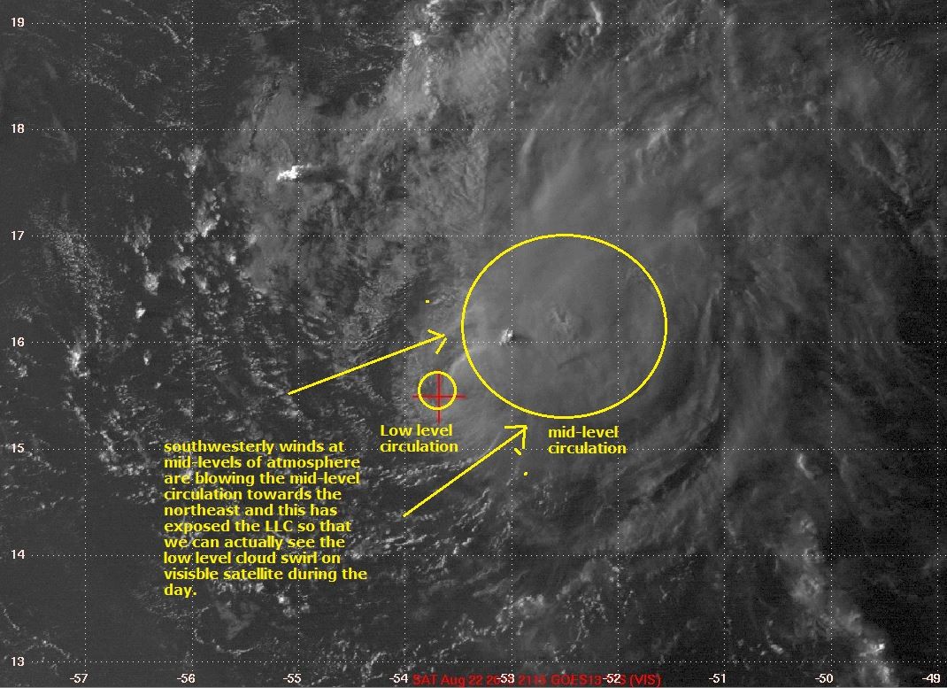
#1509 Postby idaknowman » Sat Aug 22, 2015 6:02 pm

What exactly does it mean that the center is exposed?

wxman57 wrote:A final shot of Danny before darkness overtakes it. Center completely exposed (red crosshairs). Only a couple of squalls remaining. If this shear keeps up like it is now, then Danny will not be a TS when it reaches the Caribbean. Maybe not even a TD. Rainfall chances may be dropping for the islands.

http://home.comcast.net/~cgh57/dannyvis.JPG
0 likes   
The posts in this forum are NOT official forecast and should not be used as such. They are just the opinion of the poster and may or may not be backed by sound meteorological data. They are NOT endorsed by any professional institution or storm2k.org. For official information, please refer to the NHC and NWS products.

User avatar
Gustywind
Category 5
Category 5
Posts: 12334
Joined: Mon Sep 03, 2007 7:29 am
Location: Baie-Mahault, GUADELOUPE

#1510 Postby Gustywind » Sat Aug 22, 2015 6:06 pm

TROPICAL CYCLONE ALERT STATEMENT

WHCA31 TAPA
HURRICANE DANNY ALERT STATEMENT
ANTIGUA AND BARBUDA METEOROLOGICAL SERVICES
6:30 PM ECT SAT, AUG 22, 2015

THIS IS FOR THE BRITISH VIRGIN ISLANDS

....HURRICANE DANNY CONTINUES TO WEAKEN AS IT MOVES SLOWLY TOWARD THE ISLANDS...

A TROPICAL STORM WATCH REMAINS IN EFFECT FOR ANTIGUA AND BARBUDA . A TROPICAL STORM WATCH MEANS THAT TROPICAL STORM CONDITIONS ARE POSSIBLE WITHIN THE WATCH AREA WITHIN 48 HOURS. A TROPICAL STORM WARNING MAY BE POSTED ON SUNDAY.

AT 5 PM ECT OR 2100Z THE CENTRE OF HURRICANE DANNY WAS LOCATED NEAR LATITUDE 15.8 NORTH, LONGITUDE 53.3 WEST OR ABOUT 662 MILES EAST SOUTH EAST OF ANGUILLA.

DANNY IS MOVING TOWARD THE WEST-NORTHWEST AT 14 MILES PER HOUR. A TURN TOWARDS THE WEST IS EXPECTED TONIGHT. ON THIS TRACK DANNY SHOULD BE MOVING ACROSS THE LEEWARD ISLANDS LATE SUNDAY OR ON MONDAY.

MAXIMUM SUSTAINED WINDS HAVE DECREASED TO NEAR 75 MILES PER HOUR. DANNY CONTINUES TO WEAKEN AND IS EXPECTED TO BECOME A TROPICAL STORM LATER TONIGHT OR ON SUNDAY. FURTHER WEAKENING IS EXPECTED AS DANNY CROSSES THE LEEWARD ISLANDS.

HURRICANE FORCE WINDS EXTEND OUTWARD UP TO 10 MILES FROM THE CENTRE. TROPICAL STORM FORCE WINDS EXTEND OUTWARD UP TO 60 MILES.

THE ESTIMATED MINIMUM CENTRAL PRESSURE IS 991 MB OR 29.27 INCHES.

BASED UPON THE LATEST OBSERVATION AND ANALYSIS, HURRICANE DANNY CONTINUES TO WEAKEN AS IT APPROACHES THE ISLANDS. THIS MEANS THAT LESS WIND CONDITIONS COULD AFFECT ANTIGUA AND BARBUDA. SUSTAINED WINDS OF 20-30 KTS ARE POSSIBLE WITH POSSIBLE HIGHER GUSTS TO 45 KTS.

ALL RESIDENTS ARE URGED TO MONITOR THE MOVEMENT OF DANNY.


REPEATING THE 5:00 PM ECT POSITION, 15.8 N, 53.3 W. MOVEMENT TOWARD THEWEST-NORTHWEST NEAR 14 MPH. MAXIMUM SUSTAINED WINDS ARE NEAR 75 MPH. THE MINIMUM CENTRAL PRESSURE IS 991MB.

THE NEXT ADVISORY WILL BE AT 8:30 ECT

CLICK HERE FOR MORE INFORMATION

FORECASTER KEITHLEY MEADE
0 likes   

Nederlander
S2K Supporter
S2K Supporter
Posts: 1250
Joined: Sat Jul 19, 2008 4:28 pm
Location: Conroe, TX

Re: ATL: DANNY - Hurricane- Discussion

#1511 Postby Nederlander » Sat Aug 22, 2015 6:08 pm

idaknowman wrote:What exactly does it mean that the center is exposed?

wxman57 wrote:A final shot of Danny before darkness overtakes it. Center completely exposed (red crosshairs). Only a couple of squalls remaining. If this shear keeps up like it is now, then Danny will not be a TS when it reaches the Caribbean. Maybe not even a TD. Rainfall chances may be dropping for the islands.

http://home.comcast.net/~cgh57/dannyvis.JPG


it means the center of circulation is void of convection, hence the term "naked swirl". RECON verified a tilted coc earlier. With the circulation unstacked and void of convection, it is more prone to getting sheared apart and completely uncoupled from the mid and upper level circulations.

Edit: I should also add that if you watch a loop of the latest vis imagery before sunset, you can see the low level swirl racing out ahead of the convection that is to the north and east.
0 likes   

ozonepete
Professional-Met
Professional-Met
Posts: 4743
Joined: Mon Sep 07, 2009 3:23 pm
Location: From Ozone Park, NYC / Now in Brooklyn, NY

Re: ATL: DANNY - Hurricane- Discussion

#1512 Postby ozonepete » Sat Aug 22, 2015 6:16 pm

Thanks, Nederlander. Here's an annotation of that satellite image to explain it visually..

Image
0 likes   

User avatar
wxman57
Moderator-Pro Met
Moderator-Pro Met
Posts: 22978
Age: 67
Joined: Sat Jun 21, 2003 8:06 pm
Location: Houston, TX (southwest)

Re: ATL: DANNY - Hurricane- Discussion

#1513 Postby wxman57 » Sat Aug 22, 2015 6:22 pm

Here's another shot of Danny. It may not qualify for upgrade to a tropical storm in its current state. NHC will have to downgrade on their intermediate advisory. There's almost nothing left now. Just a single thunderstorm SE of the center.

Image
0 likes   

ozonepete
Professional-Met
Professional-Met
Posts: 4743
Joined: Mon Sep 07, 2009 3:23 pm
Location: From Ozone Park, NYC / Now in Brooklyn, NY

Re: ATL: DANNY - Hurricane- Discussion

#1514 Postby ozonepete » Sat Aug 22, 2015 6:24 pm

There a 2 centers now. The one wxman targeted in the red crosshairs is dissipating and another one has formed closer to the mid-level center. This is common as a heavily sheared TC fights to maintain itself...
0 likes   

ozonepete
Professional-Met
Professional-Met
Posts: 4743
Joined: Mon Sep 07, 2009 3:23 pm
Location: From Ozone Park, NYC / Now in Brooklyn, NY

Re: ATL: DANNY - Hurricane- Discussion

#1515 Postby ozonepete » Sat Aug 22, 2015 6:26 pm

But wow, what a mess. Shredded wheat lol.
0 likes   

User avatar
gatorcane
S2K Supporter
S2K Supporter
Posts: 23691
Age: 47
Joined: Sun Mar 13, 2005 3:54 pm
Location: Boca Raton, FL

#1516 Postby gatorcane » Sat Aug 22, 2015 6:26 pm

Yep :uarrow: This thing is fading quick. Maybe nothing but a swirl by tomorrow morning. But no surprise, no good model showed this thing surviving anyway.

Time to look at the wave to the east which now has a 60% chance of development and should be in the vicinity Danny is in now in about 3 or 4 days.
0 likes   

wxsouth
Professional-Met
Professional-Met
Posts: 69
Joined: Sat Jul 09, 2005 6:57 am

Re: ATL: DANNY - Hurricane- Discussion

#1517 Postby wxsouth » Sat Aug 22, 2015 6:29 pm

wxman57 wrote:Here's another shot of Danny. It may not qualify for upgrade to a tropical storm in its current state. NHC will have to downgrade on their intermediate advisory. There's almost nothing left now. Just a single thunderstorm SE of the center.


I think your 'X' is about a degree too far north and a little west...last VDM had 15.6/-53.7 for the center.

Regardless, Danny is decoupling and will continue to weaken despite sporadic convective bursts.
0 likes   

Brent
S2K Supporter
S2K Supporter
Posts: 38089
Age: 36
Joined: Sun May 16, 2004 10:30 pm
Location: Tulsa Oklahoma
Contact:

Re: ATL: DANNY - Hurricane- Discussion

#1518 Postby Brent » Sat Aug 22, 2015 6:46 pm

this thing is an insult to hurricanes

Image
0 likes   
#neversummer

User avatar
bahamaswx
Category 5
Category 5
Posts: 1542
Joined: Sat Sep 13, 2003 1:11 am
Location: Georgetown, Bahamas

Re: ATL: DANNY - Hurricane- Discussion

#1519 Postby bahamaswx » Sat Aug 22, 2015 6:52 pm

https://en.m.wikipedia.org/wiki/Hurrica ... %282002%29

A good example of a storm that I'm sure everyone will remember. Fought through several bouts of terrible shear and rose back from the dead several times. Very memorable.

I'm not saying that Danny will regenerate, just that we've all seen "dead" storms come back time and time again.
0 likes   

tolakram
Admin
Admin
Posts: 20009
Age: 62
Joined: Sun Aug 27, 2006 8:23 pm
Location: Florence, KY (name is Mark)

Re: ATL: DANNY - Hurricane- Discussion

#1520 Postby tolakram » Sat Aug 22, 2015 6:53 pm

0 likes   
M a r k
- - - - -
Join us in chat: Storm2K Chatroom Invite. Android and IOS apps also available.

The posts in this forum are NOT official forecasts and should not be used as such. Posts are NOT endorsed by any professional institution or STORM2K.org. For official information and forecasts, please refer to NHC and NWS products.


Return to “2015”

Who is online

Users browsing this forum: No registered users and 7 guests