ATL: ERIKA - Remnants - Discussion
Moderator: S2k Moderators
-
floridasun78
- Category 5

- Posts: 3755
- Joined: Sun May 17, 2009 10:16 pm
- Location: miami fl
Re: ATL: ERIKA - Tropical Storm - Discussion
like weather channel saying miami not got hit by hurr long time that was Wilma their say miami people not are ready hurr their got feeling this not coming here Florida EOC and dade , Broward and palm beach EOC worry about that we here south fl do thing last min because not many have pass hurr most did left south fl other reason
0 likes
-
floridasun78
- Category 5
- Posts: 3755
- Joined: Sun May 17, 2009 10:16 pm
- Location: miami fl

-
AdamFirst

- S2K Supporter

- Posts: 2490
- Age: 36
- Joined: Thu Aug 14, 2008 10:54 am
- Location: Port Saint Lucie, FL
Re:
Alyono wrote:the convection is really starting to weaken and the pressure continues to rise. Likely no intensification today. We have to wait 2 to 3 days before this starts to organize
Would the environment ahead be supportive enough to maintain its current intensity or around it?
0 likes
Dolphins Marlins Canes Golden Panthers HEAT
Andrew 1992 - Irene 1999 - Frances 2004 - Jeanne 2004 - Wilma 2005 - Fay 2008 - Isaac 2012 - Matthew 2016 - Irma 2017 - Dorian 2019 - Ian 2022 - Nicole 2022 - Milton 2024
Andrew 1992 - Irene 1999 - Frances 2004 - Jeanne 2004 - Wilma 2005 - Fay 2008 - Isaac 2012 - Matthew 2016 - Irma 2017 - Dorian 2019 - Ian 2022 - Nicole 2022 - Milton 2024
-
adam0983
Re:
I am in Boca Raton Florida based on the current models what should the conditions be. I am not buying into the models I still believe that Tropical Storm Erika will miss Florida and turn away. Why is this storm different from the other storms that have turned away like Hurricane Sandy and Hurricane Floyd. Just an opinion not a forecast.
Personal Forecast Disclaimer:
The posts in this forum are NOT official forecast and should not be used as such. They are just the opinion of the poster and may or may not be backed by sound meteorological data. They are NOT endorsed by any professional institution or storm2k.org. For official information, please refer to the NHC and NWS products.
Last edited by tolakram on Wed Aug 26, 2015 9:40 am, edited 1 time in total.
Reason: added disclaimer
Reason: added disclaimer
0 likes

Re: Re:
AdamFirst wrote:Alyono wrote:the convection is really starting to weaken and the pressure continues to rise. Likely no intensification today. We have to wait 2 to 3 days before this starts to organize
Would the environment ahead be supportive enough to maintain its current intensity or around it?
As long as it does not go over Hispañiola
0 likes
-
SouthFLTropics

- Category 5
- Posts: 4258
- Age: 50
- Joined: Thu Aug 14, 2003 8:04 am
- Location: Port St. Lucie, Florida
The low level circulation is quite large and vigorous and really looks good...when it eventually stacks this thing could really take off.
SFT
SFT
0 likes
Fourth Generation Florida Native
Personal Storm History: David 79, Andrew 92, Erin 95, Floyd 99, Irene 99, Frances 04, Jeanne 04, Wilma 05, Matthew 16, Irma 17, Ian 22, Nicole 22, Milton 24
Personal Storm History: David 79, Andrew 92, Erin 95, Floyd 99, Irene 99, Frances 04, Jeanne 04, Wilma 05, Matthew 16, Irma 17, Ian 22, Nicole 22, Milton 24
-
Blown Away

- S2K Supporter
- Posts: 10253
- Joined: Wed May 26, 2004 6:17 am
Re:
Alyono wrote:the convection is really starting to weaken and the pressure continues to rise. Likely no intensification today. We have to wait 2 to 3 days before this starts to organize
Slow intensifcation during the next 36 hours is not good for SFL... Kinda hoping Erika takes off sooner and harmlessly recurves to our east as depicted by GFDL model runs...
0 likes
Hurricane Eye Experience: David 79, Irene 99, Frances 04, Jeanne 04, Wilma 05… Hurricane Brush Experience: Andrew 92, Erin 95, Floyd 99, Matthew 16, Irma 17, Ian 22, Nicole 22…

Re: Re:
Alyono wrote:AdamFirst wrote:Alyono wrote:the convection is really starting to weaken and the pressure continues to rise. Likely no intensification today. We have to wait 2 to 3 days before this starts to organize
Would the environment ahead be supportive enough to maintain its current intensity or around it?
As long as it does not go over Hispañiola
It looks like it could. Its looks like its going to miss its forecast point
0 likes
Robbielyn McCrary
I know just about enough to sound like I know what I'm talking about sometimes. But for your safety please follow the nhc for truly professional forecasting.
I know just about enough to sound like I know what I'm talking about sometimes. But for your safety please follow the nhc for truly professional forecasting.
-
Bocadude85

- Category 5
- Posts: 2991
- Age: 39
- Joined: Mon Apr 18, 2005 2:20 pm
- Location: Honolulu,Hi
Re: ATL: ERIKA - Tropical Storm - Discussion
wxman57 wrote:Recon found Erika's center on the NW tip of the convection, indicating conditions aloft are still not quite right. All model guidance is in good agreement on a possible S. FL threat Monday morning. How strong it will be when it nears S. FL is still the big question, and that question may not be resolved until this weekend. If I was in S. FL then I'd make sure that my hurricane kit was in order and that my pantry was full of non-perishable goods, etc., etc..
Great advice. Thanks.
0 likes
-
'CaneFreak

- Category 5
- Posts: 1487
- Joined: Mon Jun 05, 2006 10:50 am
- Location: New Bern, NC
Re: ATL: ERIKA - Tropical Storm - Discussion
Do you have a link for that? I don't see it on their website.
Edit: Never mind. Found it.
Edit: Never mind. Found it.
PTrackerLA wrote:Heard state of Florida EOC activated and they are at a level 2 (monitoring situation)
Last edited by 'CaneFreak on Wed Aug 26, 2015 9:49 am, edited 1 time in total.
0 likes
-
Bocadude85
- Category 5
- Posts: 2991
- Age: 39
- Joined: Mon Apr 18, 2005 2:20 pm
- Location: Honolulu,Hi
Re: ATL: ERIKA - Tropical Storm - Discussion
NHC is showing landfall in Palm Beach County now
0 likes
Re: ATL: ERIKA - Tropical Storm - Discussion
Bocadude85 wrote:NHC is showing landfall in Palm Beach County now
More like northern Broward County to me.
0 likes

Re: ATL: ERIKA - Tropical Storm - Discussion
Bocadude85 wrote:NHC is showing landfall in Palm Beach County now
"How close can it get" from the StormCarib website shows the closest it gets to me (in Palm Beach County; Lake Worth at 26.6/80.2) is 17.2 miles on Monday late morning. Basically exactly 120 hours from now. Local Met also says on current course and forecast; TS Watches as early as Friday.
A little TOO close for comfort.....
0 likes
Personal Forecast Disclaimer:
My posts are just my opinion and are most likely not backed by sound meteorological data. They are NOT endorsed by any professional institution or storm2k.org. For official information, please refer to the NHC and NWS products.
Bottom line is that I am just expressing my opinion!!!
My posts are just my opinion and are most likely not backed by sound meteorological data. They are NOT endorsed by any professional institution or storm2k.org. For official information, please refer to the NHC and NWS products.
Bottom line is that I am just expressing my opinion!!!
-
Hurricaneman
- Category 5
- Posts: 7404
- Age: 45
- Joined: Tue Aug 31, 2004 3:24 pm
- Location: central florida
Re: ATL: ERIKA - Tropical Storm - Discussion
fci wrote:Bocadude85 wrote:NHC is showing landfall in Palm Beach County now
"How close can it get" from the StormCarib website shows the closest it gets to me (in Palm Beach County; Lake Worth at 26.6/80.2) is 17.2 miles on Monday late morning. Basically exactly 120 hours from now. Local Met also says on current course and forecast; TS Watches as early as Friday.
A little TOO close for comfort.....
Might end up being hurricane watches
0 likes
-
Gustywind

- Category 5
- Posts: 12334
- Joined: Mon Sep 03, 2007 7:29 am
- Location: Baie-Mahault, GUADELOUPE
000
WTNT35 KNHC 261446
TCPAT5
BULLETIN
TROPICAL STORM ERIKA ADVISORY NUMBER 7
NWS NATIONAL HURRICANE CENTER MIAMI FL AL052015
1100 AM AST WED AUG 26 2015
...ERIKA CONTINUES WESTWARD TOWARD THE LEEWARD ISLANDS...
SUMMARY OF 1100 AM AST...1500 UTC...INFORMATION
-----------------------------------------------
LOCATION...16.1N 57.6W
ABOUT 285 MI...460 KM ESE OF ANTIGUA
MAXIMUM SUSTAINED WINDS...45 MPH...75 KM/H
PRESENT MOVEMENT...W OR 280 DEGREES AT 17 MPH...28 KM/H
MINIMUM CENTRAL PRESSURE...1005 MB...29.68 INCHES
WATCHES AND WARNINGS
--------------------
CHANGES WITH THIS ADVISORY:
The government of France has changed the Tropical Storm Watch to a
Tropical Storm Warning for St. Martin and St. Barthelemy.
SUMMARY OF WATCHES AND WARNINGS IN EFFECT:
A Tropical Storm Warning is in effect for...
* Anguilla
* Saba and St. Eustatius
* St. Maarten
* St. Martin
* St. Barthelemy
* Montserrat
* Antigua and Barbuda
* St. Kitts and Nevis
* Puerto Rico
* Vieques
* Culebra
* U.S. Virgin Islands
* British Virgin Islands
A Tropical Storm Watch is in effect for...
* Guadeloupe
A Tropical Storm Warning means that tropical storm conditions are
expected somewhere within the warning area, generally within 36
hours.
A Tropical Storm Watch means that tropical storm conditions are
possible within the watch area, generally within 48 hours.
Interests in the Dominican Republic should monitor the progress of
Erika. A Tropical Storm Watch may be required for a portion of the
Dominican Republic later today.
For storm information specific to your area in the United States,
including possible inland watches and warnings, please monitor
products issued by your local National Weather Service forecast
office. For storm information specific to your area outside the
United States, please monitor products issued by your national
meteorological service.
0 likes

Re: ATL: ERIKA - Tropical Storm - Discussion
i the meantime, it has to pass the islands before it gets to Florida and I would like to see some discussion on that. We in the islands got messed up last year by Gonzalo because NHC mis forecast. I hope that is not going to happen with Erika.
0 likes
Too many hurricanes to remember
-
Blown Away
- S2K Supporter
- Posts: 10253
- Joined: Wed May 26, 2004 6:17 am
Re: ATL: ERIKA - Tropical Storm - Discussion
msbee wrote:i the meantime, it has to pass the islands before it gets to Florida and I would like to see some discussion on that. We in the islands got messed up last year by Gonzalo because NHC mis forecast. I hope that is not going to happen with Erika.
Yep, it looks like a squally mess going to move over your area... Nearly all the models show no more than weak TS until passing near Hispaniola... Hope you get a bunch of rain if you need it...
0 likes
Hurricane Eye Experience: David 79, Irene 99, Frances 04, Jeanne 04, Wilma 05… Hurricane Brush Experience: Andrew 92, Erin 95, Floyd 99, Matthew 16, Irma 17, Ian 22, Nicole 22…

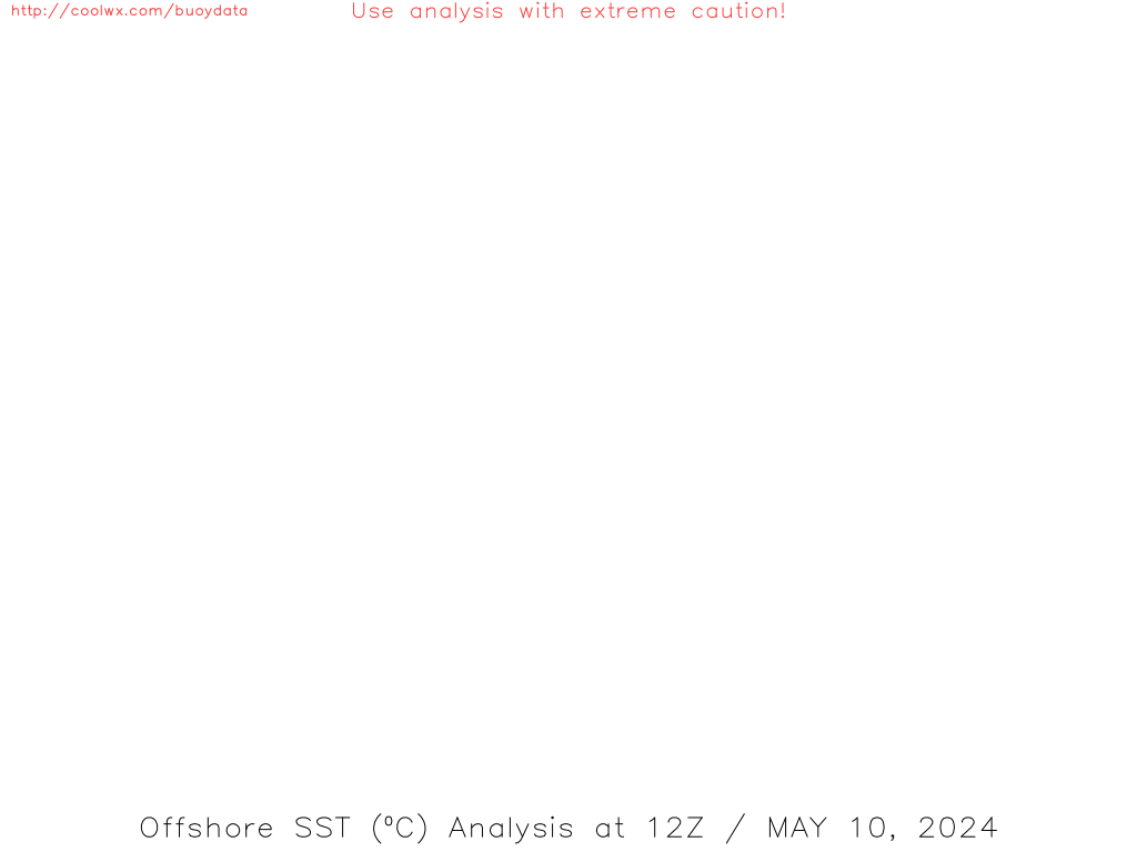
Not a forecast...just a thought: I have seen posts and websites talking about the worst case being a direct hit on Miami. Well there is the Key west to Tampa scenario, which I think is just as bad. Water temps are warmer on the W coast of FL: http://coolwx.com/buoydata/data/t-02/gu ... alysis.png. You get a Charley like NNW instead of NNE. You would basically have the entire W side of the state in the NE quad. Final landfall West of the Big Bend will give massive storm surge. I won't even mention the Miami to New Orleans that Andrew almost pulled... Given the upper low on the models backing away, Erika would have as good as an environment to maintain or ramp up.
Personal Forecast Disclaimer:
The posts in this forum are NOT official forecast and should not be used as such. They are just the opinion of the poster and may or may not be backed by sound meteorological data. They are NOT endorsed by any professional institution or storm2k.org. For official information, please refer to the NHC and NWS products.
0 likes
Who is online
Users browsing this forum: No registered users and 91 guests