ATL: ERIKA - Remnants - Discussion
Moderator: S2k Moderators


Re: ATL: ERIKA - Tropical Storm - Discussion
Can someone give a rundown of this possible center relocation that was discussed recently?
0 likes
-
ozonepete
- Professional-Met

- Posts: 4743
- Joined: Mon Sep 07, 2009 3:23 pm
- Location: From Ozone Park, NYC / Now in Brooklyn, NY
Re: Re:
CronkPSU wrote:SunnyThoughts wrote:Saw this on another board. Interesting about the lightning.
000
URNT12 KWBC 262302
VORTEX DATA MESSAGE AL052015
A. 26/22:36:43Z
B. 16 deg 16 min N
059 deg 04 min W
C. 700 mb 3145 m
D. 27 kt
E. 360 deg 0 nm
F. 091 deg 36 kt
G. 002 deg 67 nm
H. 1006 mb
I. 13 C / 3056 m
J. 12 C / 3059 m
K. 8 C / NA
L. NA
M. NA
N. 134 / 7
O. 1 / 15 nm
P. NOAA3 0305A ERIKA OB 26
STRONG BANDING SE
FREQUENT LIGHTNING SE
MAX FL WIND 36 KT 002 / 67 NM 22:20:49Z
MAX FL TEMP 14 C 003 / 34 NM FROM FL CNTR
CNTR DROPSONDE SFC WIND 180 / 20 KTS
If I remember right (and hope a ProMet clears this up) that is a sign of a weak storm or a developing one (yeah that isn't much help but combined with the better radar presence, I would think this is not good and the storm is strengthening again)...a stronger storm would not have frequent lightning
Frequent lightning is a classic sign of strengthening in any tropical cyclone. It means thunderstorms are rising in height very quickly, or what we call hot towers. I've never heard of it being a sign of a weak storm. And for the big, monster cat 4 or 5 hurricanes, many times RECON has reported incredibly vivid lightning in their eyewalls.
0 likes
-
TropicalAnalystwx13

- Category 5

- Posts: 2109
- Age: 28
- Joined: Tue Jul 19, 2011 8:20 pm
- Location: Wilmington, NC
- Contact:
Re: ATL: ERIKA - Tropical Storm - Discussion
Siker wrote:Can someone give a rundown of this possible center relocation that was discussed recently?
Not seeing any signs of a center relocation. The defined low-level circulation remains on the northwestern edge of the recent convective burst.
Recon found surface winds of 40-45kt. Erika is at least maintaining intensity at this point.
0 likes

Re: ATL: ERIKA - Tropical Storm - Discussion
Looks pretty ragged tonite. Wouldn't be surprised if it degenerates into an open wave in the next few days. The NHC talked about this possibility in their discussion. Wonder what the models will do if that's the case?
0 likes
-
wxman57

- Moderator-Pro Met

- Posts: 23172
- Age: 68
- Joined: Sat Jun 21, 2003 8:06 pm
- Location: Houston, TX (southwest)
Re: ATL: ERIKA - Tropical Storm - Discussion
The center didn't dissipate. There are new squalls developing near it, as is evident by satellite imagery and the frequent lightning observed. It's struggling but it's still alive. No change in the forecast track. Will likely be a close call for Florida but I think it will turn north before reaching the coast.
0 likes
-
ozonepete
- Professional-Met
- Posts: 4743
- Joined: Mon Sep 07, 2009 3:23 pm
- Location: From Ozone Park, NYC / Now in Brooklyn, NY
Re: ATL: ERIKA - Tropical Storm - Discussion
wxman57 wrote:The center didn't dissipate. There are new squalls developing near it, as is evident by satellite imagery and the frequent lightning observed. It's struggling but it's still alive. No change in the forecast track. Will likely be a close call for Florida but I think it will turn north before reaching the coast.
More good analysis. I'm coming more and more towards your view on better chances for Florida missing this one in a close call.
0 likes


-
Bocadude85

- Category 5
- Posts: 2991
- Age: 39
- Joined: Mon Apr 18, 2005 2:20 pm
- Location: Honolulu,Hi
Re: ATL: ERIKA - Tropical Storm - Discussion
wxman57 wrote:The center didn't dissipate. There are new squalls developing near it, as is evident by satellite imagery and the frequent lightning observed. It's struggling but it's still alive. No change in the forecast track. Will likely be a close call for Florida but I think it will turn north before reaching the coast.
How close of a call are you thinking? Not buying the 18z HWRF that's east of the Bahamas?
0 likes
-
wxman57
- Moderator-Pro Met
- Posts: 23172
- Age: 68
- Joined: Sat Jun 21, 2003 8:06 pm
- Location: Houston, TX (southwest)
Re: ATL: ERIKA - Tropical Storm - Discussion
Bocadude85 wrote:wxman57 wrote:The center didn't dissipate. There are new squalls developing near it, as is evident by satellite imagery and the frequent lightning observed. It's struggling but it's still alive. No change in the forecast track. Will likely be a close call for Florida but I think it will turn north before reaching the coast.
How close of a call are you thinking? Not buying the 18z HWRF that's east of the Bahamas?
I think that for Erika to track east of the Bahamas it would have to get strong very quickly/soon. If Erika takes longer to strengthen, then it will turn later.
0 likes
-
Bocadude85
- Category 5
- Posts: 2991
- Age: 39
- Joined: Mon Apr 18, 2005 2:20 pm
- Location: Honolulu,Hi
Re: ATL: ERIKA - Tropical Storm - Discussion
wxman57 wrote:Bocadude85 wrote:wxman57 wrote:The center didn't dissipate. There are new squalls developing near it, as is evident by satellite imagery and the frequent lightning observed. It's struggling but it's still alive. No change in the forecast track. Will likely be a close call for Florida but I think it will turn north before reaching the coast.
How close of a call are you thinking? Not buying the 18z HWRF that's east of the Bahamas?
I think that for Erika to track east of the Bahamas it would have to get strong very quickly/soon. If Erika takes longer to strengthen, then it will turn later.
Ok thank you. So we could still possibly have some effects from Erika here in South Florida?
Last edited by Bocadude85 on Wed Aug 26, 2015 7:17 pm, edited 1 time in total.
0 likes

Looks like there's a good west-to-east inflow shaping up to the east of Martinique close to the circulation, so this should help keep it from opening up at least through the night.
With Erika coming within radar range, and likely staying somewhat close to land, a lot of the guesswork (center and organization) between recon flights should at least be removed for some time.
With Erika coming within radar range, and likely staying somewhat close to land, a lot of the guesswork (center and organization) between recon flights should at least be removed for some time.
0 likes
The above post is not official and should not be used as such. It is the opinion of the poster and may or may not be backed by sound meteorological data. It is not endorsed by any professional institution or storm2k.org. For official information, please refer to the NHC and NWS products.
-
EquusStorm
- Category 5
- Posts: 1649
- Age: 35
- Joined: Thu Nov 07, 2013 1:04 pm
- Location: Jasper, AL
- Contact:
Basically it looks like if Florida is going to be directly impacted, it's going to need to stay weak, but not TOO weak, then intensify quickly once it approaches the Bahamas... too much weakening and it runs the risk of running ashore in Hispaniola and tearing itself apart (not to mention dumping enough rain to cause devastating mudslides in Haiti) but too much strengthening fairly early on and it will be more susceptible to early re-curvature. Obviously the worst case scenario for Florida would be a rate somewhere between these extremes.
As much as I would like to work in such a field, I really don't envy those who have to put out an official forecast in situations like this. So many variables.
As much as I would like to work in such a field, I really don't envy those who have to put out an official forecast in situations like this. So many variables.
0 likes
Colors of lost purpose on the canvas of irrelevance
Not a meteorologist, in fact more of an idiot than anything. You should probably check with the NHC or a local NWS office for official information.
Not a meteorologist, in fact more of an idiot than anything. You should probably check with the NHC or a local NWS office for official information.
Re:
NDG wrote:Erika still a tropical storm, NE quadrant where basically is convection free so this is all pressure gradient winds.
001330 1707N 05907W 8437 01570 0105 +180 +073 110031 032 037 000 00
I wouldn't call it gradient winds considering the winds were stronger to the east under the deepest convection.

Erika trying to establish some actual outflow to the west and north, but there's a tongue of dry air moving south that could undercut it.
0 likes
The above post is not official and should not be used as such. It is the opinion of the poster and may or may not be backed by sound meteorological data. It is not endorsed by any professional institution or storm2k.org. For official information, please refer to the NHC and NWS products.
-
tolakram
- Admin

- Posts: 20179
- Age: 62
- Joined: Sun Aug 27, 2006 8:23 pm
- Location: Florence, KY (name is Mark)
Re: ATL: ERIKA - Tropical Storm - Discussion
Mid-level water vapor looks pretty good, it's not a desert out there like it has been for the last 2 years.
http://tropic.ssec.wisc.edu/real-time/salmain.php?&prod=wvmid&time=
http://tropic.ssec.wisc.edu/real-time/salmain.php?&prod=wvmid&time=
0 likes
M a r k
- - - - -
Join us in chat: Storm2K Chatroom Invite. Android and IOS apps also available.
The posts in this forum are NOT official forecasts and should not be used as such. Posts are NOT endorsed by any professional institution or STORM2K.org. For official information and forecasts, please refer to NHC and NWS products.
-
Gustywind

- Category 5
- Posts: 12334
- Joined: Mon Sep 03, 2007 7:29 am
- Location: Baie-Mahault, GUADELOUPE
000
WTNT35 KNHC 262338
TCPAT5
BULLETIN
TROPICAL STORM ERIKA INTERMEDIATE ADVISORY NUMBER 8A
NWS NATIONAL HURRICANE CENTER MIAMI FL AL052015
800 PM AST WED AUG 26 2015
...POORLY ORGANIZED ERIKA EXPECTED TO MOVE THROUGH THE LEEWARD
ISLANDS OVERNIGHT...
SUMMARY OF 800 PM AST...0000 UTC...INFORMATION
----------------------------------------------
LOCATION...16.7N 59.5W
ABOUT 155 MI...250 KM E OF ANTIGUA
MAXIMUM SUSTAINED WINDS...45 MPH...75 KM/H
PRESENT MOVEMENT...W OR 280 DEGREES AT 17 MPH...28 KM/H
MINIMUM CENTRAL PRESSURE...1006 MB...29.71 INCHES
WATCHES AND WARNINGS
--------------------
CHANGES WITH THIS ADVISORY:
None.
SUMMARY OF WATCHES AND WARNINGS IN EFFECT:
A Tropical Storm Warning is in effect for...
* Anguilla
* Saba and St. Eustatius
* St. Maarten
* St. Martin
* St. Barthelemy
* Montserrat
* Antigua and Barbuda
* St. Kitts and Nevis
* Puerto Rico
* Vieques
* Culebra
* U.S. Virgin Islands
* British Virgin Islands
A Tropical Storm Watch is in effect for...
* Guadeloupe
* North coast of the Dominican Republic from Cabo Engano to Cabo
Frances Viejo
* Southeastern Bahamas
* Turks and Caicos Islands
A Tropical Storm Watch means that tropical storm conditions are
possible within the watch area, generally within 48 hours.
Interests elsewhere in the Dominican Republic should monitor the
progress of Erika.
For storm information specific to your area in the United
States, including possible inland watches and warnings, please
monitor products issued by your local National Weather Service
forecast office. For storm information specific to your area outside
the United States, please monitor products issued by your national
meteorological service.
0 likes
-
ObsessedMiami

- Category 1

- Posts: 432
- Joined: Tue Aug 31, 2004 8:08 pm
- Location: West Kendall, Fl
Re: ATL: ERIKA - Tropical Storm - Discussion
It is always a fascinating insight into human nature here. The storm hasn't even approached the Antilles yet and the comments flip flop based on this model trend or another. Honestly, I don't think anything, models or otherwise, have any real traction until the storm passes Hispanola and we see what we are getting. I also don't envy those who have to make rather large decisions regarding EOC planning based on this storm.
Just my opinion.
Just my opinion.
0 likes
Re: ATL: ERIKA - Tropical Storm - Discussion
well, if there is a reformation of the center (which I don't think there is) it would slow the arrival of Erika into the Bahamas and could miss the weakness. Just throwing that out there.
0 likes
-
cycloneye

- Admin
- Posts: 149310
- Age: 69
- Joined: Thu Oct 10, 2002 10:54 am
- Location: San Juan, Puerto Rico
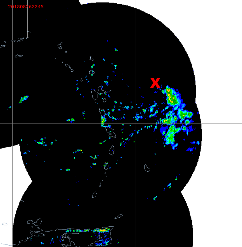
Re:
Hammy wrote:Looks like there's a good west-to-east inflow shaping up to the east of Martinique close to the circulation, so this should help keep it from opening up at least through the night.
With Erika coming within radar range, and likely staying somewhat close to land, a lot of the guesswork (center and organization) between recon flights should at least be removed for some time.
Great radar composite here.
http://www.barbadosweather.org/Composit ... 1440635457
0 likes
Visit the Caribbean-Central America Weather Thread where you can find at first post web cams,radars
and observations from Caribbean basin members Click Here
and observations from Caribbean basin members Click Here
Re: Re:
Looks like the circulation is becoming a bit better defined, it's just west of the red blob of rain if you flip between 2345-0015.
0 likes
The above post is not official and should not be used as such. It is the opinion of the poster and may or may not be backed by sound meteorological data. It is not endorsed by any professional institution or storm2k.org. For official information, please refer to the NHC and NWS products.
Who is online
Users browsing this forum: No registered users and 27 guests