Post tonight on Erika, 99L:
http://jonathanbelles.com/2015/08/29/er ... e-islands/
ATL: ERIKA - Remnants - Discussion
Moderator: S2k Moderators
-
JonathanBelles
- Professional-Met

- Posts: 11430
- Age: 35
- Joined: Sat Dec 24, 2005 9:00 pm
- Location: School: Florida State University (Tallahassee, FL) Home: St. Petersburg, Florida
- Contact:

Re:
JonathanBelles wrote:Post tonight on Erika, 99L:
http://jonathanbelles.com/2015/08/29/er ... e-islands/
hi I live in spring hill fl 40miles northwest of tama 10 miles from the coast. will we have any sustained winds at all like 25 or 30 or will we be out of the wind field d/t erika being 100-150 away from the coast out in the gulf?
0 likes
Robbielyn McCrary
I know just about enough to sound like I know what I'm talking about sometimes. But for your safety please follow the nhc for truly professional forecasting.
I know just about enough to sound like I know what I'm talking about sometimes. But for your safety please follow the nhc for truly professional forecasting.
Re: Re:
robbielyn wrote:JonathanBelles wrote:Post tonight on Erika, 99L:
http://jonathanbelles.com/2015/08/29/er ... e-islands/
hi I live in spring hill fl. 10 miles from the coast. will we have any sustained winds at all like 25 or 30 or will we be out of the wind field d/t erika being 100-150 away from the coast out in the gulf?
also will there be any high pressure gradient winds? sorry I see u r from st pete.
0 likes
Robbielyn McCrary
I know just about enough to sound like I know what I'm talking about sometimes. But for your safety please follow the nhc for truly professional forecasting.
I know just about enough to sound like I know what I'm talking about sometimes. But for your safety please follow the nhc for truly professional forecasting.
-
JonathanBelles
- Professional-Met
- Posts: 11430
- Age: 35
- Joined: Sat Dec 24, 2005 9:00 pm
- Location: School: Florida State University (Tallahassee, FL) Home: St. Petersburg, Florida
- Contact:
Re: Re:
robbielyn wrote:robbielyn wrote:JonathanBelles wrote:Post tonight on Erika, 99L:
http://jonathanbelles.com/2015/08/29/er ... e-islands/
hi I live in spring hill fl. 10 miles from the coast. will we have any sustained winds at all like 25 or 30 or will we be out of the wind field d/t erika being 100-150 away from the coast out in the gulf?
also will there be any high pressure gradient winds? sorry I see u r from st pete.
Expect a few days like today in Spring Hill. On and off showers and storms, with occasionally gusty conditions. I would not be surprised to see gusts up to 25 mph from the system. Embedded day time thunderstorms will come with the small chance of severe weather as they did in Polk county today. Winds could be higher in those storms, but they are nothing out of the ordinary for this time of the year.
0 likes


Re: Re:
robbielyn wrote:JonathanBelles wrote:Post tonight on Erika, 99L:
http://jonathanbelles.com/2015/08/29/er ... e-islands/
hi I live in spring hill fl 40miles northwest of tama 10 miles from the coast. will we have any sustained winds at all like 25 or 30 or will we be out of the wind field d/t erika being 100-150 away from the coast out in the gulf?
I'm from Jax but am currently at Hernado beach visiting the old folks I'd say depending where you are in spring hill we will get no winds lots of rain but little wind..anywhere from 19 east
0 likes
Once I see the REDS and GREENS Converge on a Base Velocity. ... I'm There!!
This is NOT an Official Forecast....Just my Opinion. For official information, please refer to the NHC and NWS products.
HIGHLIGHTS : '13 El Reno Tornado : 2013 Storm Chaser Tour, Joaquin; SC flood event, Matthew '16, Lowcountry Snow storm Jan '18
This is NOT an Official Forecast....Just my Opinion. For official information, please refer to the NHC and NWS products.
HIGHLIGHTS : '13 El Reno Tornado : 2013 Storm Chaser Tour, Joaquin; SC flood event, Matthew '16, Lowcountry Snow storm Jan '18
Re: Re:
Kohlecane wrote:robbielyn wrote:JonathanBelles wrote:Post tonight on Erika, 99L:
http://jonathanbelles.com/2015/08/29/er ... e-islands/
hi I live in spring hill fl 40miles northwest of tama 10 miles from the coast. will we have any sustained winds at all like 25 or 30 or will we be out of the wind field d/t erika being 100-150 away from the coast out in the gulf?
I'm from Jax but am currently at Hernado beach visiting the old folks I'd say depending where you are in spring hill we will get no winds lots of rain but little wind..anywhere from 19 east
well that stinks lol. I wouldnt mind a little wind otherwise it's just like a couple of weeks ago. I was wanting some interesting weather but nothing serious. but 25 gusts mean 10-15 sustained whoopie. im just glad I dont live in low lying areas like new port richey. oh well its been interesting. at least we dodged the bullet hurricane wise
0 likes
Robbielyn McCrary
I know just about enough to sound like I know what I'm talking about sometimes. But for your safety please follow the nhc for truly professional forecasting.
I know just about enough to sound like I know what I'm talking about sometimes. But for your safety please follow the nhc for truly professional forecasting.
-
HouGulf2011
- Tropical Wave

- Posts: 3
- Age: 52
- Joined: Wed Jun 01, 2011 2:59 pm
- Location: Cocoa, FL
Re: ATL: INVEST 90L - ERIKA Remnants - Discussion
I don't usually post but I'm always reading. I live in Central Florida and we have had heavy storms today and this evening. HUGE Lightning bolts just bolted out across the street and scared the mess out of me. Most of my friends here are chasers are weather photographers so I will post if anything unusual happens.
0 likes
-
floridasun78
- Category 5

- Posts: 3755
- Joined: Sun May 17, 2009 10:16 pm
- Location: miami fl
Re: ATL: INVEST 90L - ERIKA Remnants - Discussion
miami few line rain this afternoon and night we have few thunder storm too
0 likes


Re: ATL: INVEST 90L - ERIKA Remnants - Discussion
The low level Circulation that was spit out after Erika crash into Hispaniola is now heading to extreme south Fla or the Keys. gain convection, still needs to watched in case the shear lets up in eastern Gulf.
http://radar.weather.gov/ridge/radar.ph ... 1&loop=yes
http://radar.weather.gov/ridge/radar.ph ... 1&loop=yes
0 likes
The following post is NOT an official forecast and should not be used as such. It is just the opinion of the poster and may or may not be backed by sound meteorological data. It is NOT endorsed by any professional institution including storm2k.org For Official Information please refer to the NHC and NWS products.
Re: ATL: INVEST 90L - ERIKA Remnants - Discussion
That weak curl of convection south of the mid-Keys is Erika's ghost.
We had a real dumper in that first band.
We had a real dumper in that first band.
0 likes
-
beoumont

- Category 1

- Posts: 473
- Joined: Sun Jul 10, 2011 4:13 pm
- Location: East Central Florida
- Contact:
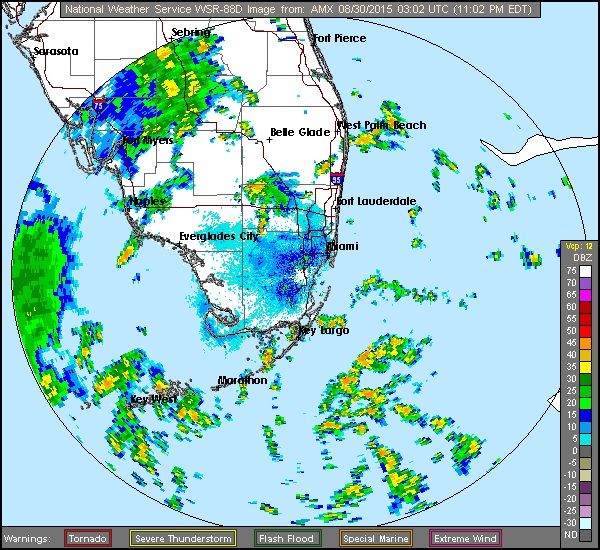
Re: ATL: INVEST 90L - ERIKA Remnants - Discussion
Here's a short range still shot of Miami's radar showing Erika's ghost/skeleton:
0 likes
List of 79 tropical cyclones intercepted by Richard Horodner:
http://www.canebeard.com/page/page/572246.htm
http://www.canebeard.com/page/page/572246.htm
-
floridasun78
- Category 5
- Posts: 3755
- Joined: Sun May 17, 2009 10:16 pm
- Location: miami fl
Re: ATL: INVEST 90L - ERIKA Remnants - Discussion
yes i saw that a lot rain keys and south flbeoumont wrote:Here's a short range still shot of Miami's radar showing Erika's ghost/skeleton:
0 likes
-
Miami Storm Tracker

- Category 4

- Posts: 916
- Age: 68
- Joined: Sun Jun 13, 2010 10:12 pm
- Location: Key Largo, Fla.
- Contact:
-
eastcoastFL

- Category 5
- Posts: 3996
- Age: 44
- Joined: Thu Apr 12, 2007 12:29 pm
- Location: Palm City, FL
Re: ATL: INVEST 90L - ERIKA Remnants - Discussion
Getting our srrongest squall so far in Palm City now endless loud thunder and tons of lighting. Also havw a monsoon style down pour right now.
Its somewhat interesting late night and not messing up schools or work so its actually perfect.
Its somewhat interesting late night and not messing up schools or work so its actually perfect.
0 likes
Personal Forecast Disclaimer:
The posts in this forum are NOT official forecast and should not be used as such. They are just the opinion of the poster and may or may not be backed by sound meteorological data. They are NOT endorsed by any professional institution or storm2k.org. For official information, please refer to the NHC and NWS products.
The posts in this forum are NOT official forecast and should not be used as such. They are just the opinion of the poster and may or may not be backed by sound meteorological data. They are NOT endorsed by any professional institution or storm2k.org. For official information, please refer to the NHC and NWS products.
-
AutoPenalti
- Category 5
- Posts: 4091
- Age: 29
- Joined: Mon Aug 17, 2015 4:16 pm
- Location: Ft. Lauderdale, Florida
No rain in Broward so far.
0 likes
The posts in this forum are NOT official forecasts and should not be used as such. They are just the opinion of the poster and may or may not be backed by sound meteorological data. They are NOT endorsed by any professional institution or STORM2K. For official information, please refer to products from the NHC and NWS.
Model Runs Cheat Sheet:
GFS (5:30 AM/PM, 11:30 AM/PM)
HWRF, GFDL, UKMET, NAVGEM (6:30-8:00 AM/PM, 12:30-2:00 AM/PM)
ECMWF (1:45 AM/PM)
TCVN is a weighted averaged
-
AutoPenalti
- Category 5
- Posts: 4091
- Age: 29
- Joined: Mon Aug 17, 2015 4:16 pm
- Location: Ft. Lauderdale, Florida
Re:
AutoPenalti wrote:No rain in Broward so far.
...and just as I post this, we get thunder.
0 likes
The posts in this forum are NOT official forecasts and should not be used as such. They are just the opinion of the poster and may or may not be backed by sound meteorological data. They are NOT endorsed by any professional institution or STORM2K. For official information, please refer to products from the NHC and NWS.
Model Runs Cheat Sheet:
GFS (5:30 AM/PM, 11:30 AM/PM)
HWRF, GFDL, UKMET, NAVGEM (6:30-8:00 AM/PM, 12:30-2:00 AM/PM)
ECMWF (1:45 AM/PM)
TCVN is a weighted averaged
-
floridasun78
- Category 5
- Posts: 3755
- Joined: Sun May 17, 2009 10:16 pm
- Location: miami fl
-
eastcoastFL
- Category 5
- Posts: 3996
- Age: 44
- Joined: Thu Apr 12, 2007 12:29 pm
- Location: Palm City, FL
Re: Re:
AutoPenalti wrote:AutoPenalti wrote:No rain in Broward so far.
...and just as I post this, we get thunder.
Haha. And my major squall has ended. We've had a handfull of on and off down pours but this was the first big heavy one.
0 likes
Personal Forecast Disclaimer:
The posts in this forum are NOT official forecast and should not be used as such. They are just the opinion of the poster and may or may not be backed by sound meteorological data. They are NOT endorsed by any professional institution or storm2k.org. For official information, please refer to the NHC and NWS products.
The posts in this forum are NOT official forecast and should not be used as such. They are just the opinion of the poster and may or may not be backed by sound meteorological data. They are NOT endorsed by any professional institution or storm2k.org. For official information, please refer to the NHC and NWS products.
-
floridasun78
- Category 5
- Posts: 3755
- Joined: Sun May 17, 2009 10:16 pm
- Location: miami fl

-
floridasun78
- Category 5
- Posts: 3755
- Joined: Sun May 17, 2009 10:16 pm
- Location: miami fl
Who is online
Users browsing this forum: No registered users and 90 guests