ATL: FRED- Remnants - Discussion
Moderator: S2k Moderators
-
CrazyC83
- Professional-Met

- Posts: 34315
- Joined: Tue Mar 07, 2006 11:57 pm
- Location: Deep South, for the first time!
From the Cape Verde internal affairs department, translated to English:
Point of situation on the island of Saint Nicholas:
Very strong wind.
For their safety, keep at home.
They are already identified housing for families with housing more precarious, if necessary.
Have in mind to information and the weather warnings of civil protection.
800 11 12-Civil protection
522 29 59-Regional Commander are Nicholas, st Vincent and santo antao.
0 likes
-
CrazyC83
- Professional-Met
- Posts: 34315
- Joined: Tue Mar 07, 2006 11:57 pm
- Location: Deep South, for the first time!
Re: ATL: FRED- Hurricane - Discussion
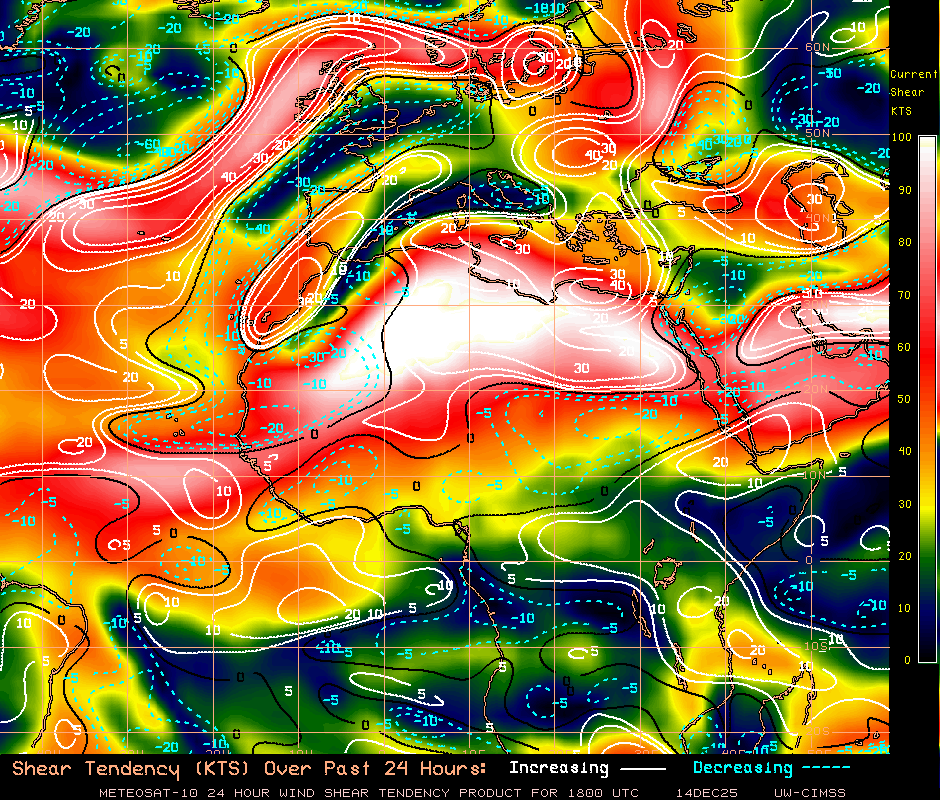
Shear really increases in the short term, but relaxes again once near 30W longitude, especially if it goes farther north. The next sweet spot looks to be near 25N 30W.
0 likes
-
leanne_uk
- Tropical Storm

- Posts: 214
- Age: 43
- Joined: Fri Sep 04, 2009 4:38 pm
- Location: Loughborough countryside, Leicestershire, UK
Thought I would pop on and update you with the info I have.... as expected all flights are cancelled until further notice. In Santa Maria my friend has said there are trees down everywhere, the power has held in her hotel for around 60% of the day. The pier has gone and countless boats have been swept away or destroyed.
A lot of the flood damage has come from rising Sea water there but someone from the hotel has an unconfirmed reading of 6.20 inches of rain so far.
My friend is so upset after what she has experienced today and altho she has another 9 days of her holiday left, she just wants to come home. Hopefully as things settle and the weather clears through she will feel a bit better about things.
I will drop an update again tomorrow and there will be a clearer picture of the damage caused as a new day starts.
0 likes
-
floridasun78
- Category 5

- Posts: 3755
- Joined: Sun May 17, 2009 10:16 pm
- Location: miami fl
Re:
leanne_uk wrote:Thought I would pop on and update you with the info I have.... as expected all flights are cancelled until further notice. In Santa Maria my friend has said there are trees down everywhere, the power has held in her hotel for around 60% of the day. The pier has gone and countless boats have been swept away or destroyed.
A lot of the flood damage has come from rising Sea water there but someone from the hotel has an unconfirmed reading of 6.20 inches of rain so far.
My friend is so upset after what she has experienced today and altho she has another 9 days of her holiday left, she just wants to come home. Hopefully as things settle and the weather clears through she will feel a bit better about things.
I will drop an update again tomorrow and there will be a clearer picture of the damage caused as a new day starts.
ty for update news here dont have any update how Cape Verde doing tell her it be over soon and we all here storm2k wish her best
0 likes


Re:
She'd better be thankful she's alive and well.leanne_uk wrote:... My friend is so upset after what she has experienced today and altho she has another 9 days of her holiday left, she just wants to come home. Hopefully as things settle and the weather clears through she will feel a bit better about things ...
0 likes
-
cycloneye

- Admin

- Posts: 149275
- Age: 69
- Joined: Thu Oct 10, 2002 10:54 am
- Location: San Juan, Puerto Rico
Re: ATL: FRED- Hurricane - Discussion
BULLETIN
HURRICANE FRED INTERMEDIATE ADVISORY NUMBER 8A
NWS NATIONAL HURRICANE CENTER MIAMI FL AL062015
800 PM AST MON AUG 31 2015
...CENTER OF FRED NEAR THE NORTHWESTERN CAPE VERDE ISLANDS...
SUMMARY OF 800 PM AST...0000 UTC...INFORMATION
----------------------------------------------
LOCATION...17.4N 25.0W
ABOUT 25 MI...40 KM NNE OF SANTO ANTAO IN THE CAPE VERDE ISLANDS
MAXIMUM SUSTAINED WINDS...75 MPH...120 KM/H
PRESENT MOVEMENT...NW OR 310 DEGREES AT 12 MPH...19 KM/H
MINIMUM CENTRAL PRESSURE...992 MB...29.29 INCHES
0 likes
Visit the Caribbean-Central America Weather Thread where you can find at first post web cams,radars
and observations from Caribbean basin members Click Here
and observations from Caribbean basin members Click Here
-
tolakram
- Admin
- Posts: 20179
- Age: 62
- Joined: Sun Aug 27, 2006 8:23 pm
- Location: Florence, KY (name is Mark)
Re: ATL: FRED- Hurricane - Discussion
0 likes
M a r k
- - - - -
Join us in chat: Storm2K Chatroom Invite. Android and IOS apps also available.
The posts in this forum are NOT official forecasts and should not be used as such. Posts are NOT endorsed by any professional institution or STORM2K.org. For official information and forecasts, please refer to NHC and NWS products.
-
cycloneye
- Admin
- Posts: 149275
- Age: 69
- Joined: Thu Oct 10, 2002 10:54 am
- Location: San Juan, Puerto Rico
BULLETIN
TROPICAL STORM FRED ADVISORY NUMBER 9
NWS NATIONAL HURRICANE CENTER MIAMI FL AL062015
1100 PM AST MON AUG 31 2015
...FRED WEAKENS TO A TROPICAL STORM...
SUMMARY OF 1100 PM AST...0300 UTC...INFORMATION
-----------------------------------------------
LOCATION...17.9N 25.2W
ABOUT 55 MI...90 KM N OF SANTO ANTAO IN THE CAPE VERDE ISLANDS
MAXIMUM SUSTAINED WINDS...70 MPH...110 KM/H
PRESENT MOVEMENT...NW OR 310 DEGREES AT 12 MPH...19 KM/H
MINIMUM CENTRAL PRESSURE...995 MB...29.39 INCHES
TROPICAL STORM FRED DISCUSSION NUMBER 9
NWS NATIONAL HURRICANE CENTER MIAMI FL AL062015
1100 PM AST MON AUG 31 2015
Fred's inner-core deep convection has collapsed, and what
thunderstorm activity remains is very ragged in appearance.
Although the convection may make somewhat of a comeback on the
diurnal maximum tomorrow morning, the current degradation of the
cloud pattern necessitates downgrading the system to a tropical
storm. The current intensity estimate is a rather uncertain 60
kt. As Fred moves away from the Cape Verde Islands, the environment
ahead becomes increasingly unfavorable with increasing shear,
progressively drier mid-level air and increased stability. The
official intensity forecast is a blend of the latest SHIPS and LGEM
guidance. Given the storm's current appearance and the hostile
future environment, however, Fred may weaken faster than indicated
here.
The center has become difficult to track, and my best guess of the
initial motion is 310/10 kt. A mid-level ridge to the north of
Fred is forecast to build gradually westward. This should cause
the cyclone to turn toward the west-northwest. A more westward
track with time is also consistent with Fred becoming a shallower
cyclone steered more by the low-level flow. The official forecast
remains on the southern side of the guidance envelope and is mostly
a blend of the latest GFS and ECMWF predictions. This is also very
similar to the previous NHC track forecast.
Please note that the track/cone graphic, an automatically generated
product, does not have the capability of displaying warnings for the
Cape Verde Islands.
FORECAST POSITIONS AND MAX WINDS
INIT 01/0300Z 17.9N 25.2W 60 KT 70 MPH
12H 01/1200Z 18.6N 26.6W 55 KT 65 MPH
24H 02/0000Z 19.6N 28.2W 50 KT 60 MPH
36H 02/1200Z 20.5N 29.9W 45 KT 50 MPH
48H 03/0000Z 21.1N 31.6W 40 KT 45 MPH
72H 04/0000Z 22.2N 34.8W 35 KT 40 MPH
96H 05/0000Z 23.5N 38.0W 30 KT 35 MPH
120H 06/0000Z 25.0N 41.0W 25 KT 30 MPH...POST-TROP/REMNT LOW
$$
Forecaster Pasch
0 likes
Visit the Caribbean-Central America Weather Thread where you can find at first post web cams,radars
and observations from Caribbean basin members Click Here
and observations from Caribbean basin members Click Here

Re: ATL: FRED- Tropical Storm - Discussion
Latest discussion
After a brief convective hiatus between about 0000-0200 UTC, deep
convection has redeveloped over the center of Fred and also in the
northern semicircle. Several passive microwave satellite images
indicate that Fred's low-level center is a little south of the
previous advisory track, due to southerly vertical wind shear
displacing most of the convection to the north of the center.
However, that same imagery also indicated that Fred still has a
low-level circulation that is quite robust, including a nearly
closed 20 n mi diameter eye.
0 likes
The above post is not official and should not be used as such. It is the opinion of the poster and may or may not be backed by sound meteorological data. It is not endorsed by any professional institution or storm2k.org. For official information, please refer to the NHC and NWS products.

Re: ATL: FRED- Tropical Storm - Discussion
Hammy wrote:Latest discussionHowever, that same imagery also indicated that Fred still has a
low-level circulation that is quite robust, including a nearly
closed 20 n mi diameter eye.
 Perhaps the trigger was being pulled too quick...though long term there is a lot of unfavorable conditions ahead of the proposed track. Interesting that it was quick to promote Erika and quick to downgrade Fred....
0 likes
-
leanne_uk
- Tropical Storm
- Posts: 214
- Age: 43
- Joined: Fri Sep 04, 2009 4:38 pm
- Location: Loughborough countryside, Leicestershire, UK
Re: Re:
Oh she most definately is. I know things could have been a whole lot worse but for someone from the UK (who is away from home for the first time without her family) to experience anything like this for the first time, it has really shook her up.
She is spending today helping with the clean up along with quite a few volunteers from her hotel.
She is spending today helping with the clean up along with quite a few volunteers from her hotel.
abajan wrote:She'd better be thankful she's alive and well.leanne_uk wrote:... My friend is so upset after what she has experienced today and altho she has another 9 days of her holiday left, she just wants to come home. Hopefully as things settle and the weather clears through she will feel a bit better about things ...
0 likes
-
cycloneye
- Admin
- Posts: 149275
- Age: 69
- Joined: Thu Oct 10, 2002 10:54 am
- Location: San Juan, Puerto Rico
Re: ATL: FRED- Tropical Storm - Discussion
TROPICAL STORM FRED DISCUSSION NUMBER 11
NWS NATIONAL HURRICANE CENTER MIAMI FL AL062015
1100 AM AST TUE SEP 01 2015
Fred continues to quickly weaken this morning as the associated
deep convection near the center has decreased in coverage and
become less organized. The center has also become exposed to the
south of the remaining shower and thunderstorm activity. The
initial intensity is reduced to 45 kt, which is based on an 1100 UTC
ASCAT pass that showed maximum winds of around 40 kt. Additional
weakening is predicted during the next few days while Fred moves
into a more hostile environment of increasing southwesterly shear,
mid-level dry air, and marginal sea surface temperatures. The
tropical cyclone is expected to weaken to a tropical depression in
36 to 48 hours, and become a remnant low in 2 to 3 days, but this
could occur sooner.
Fred is moving west-northwestward or 300 degrees at 9 kt. The
tropical cyclone is expected to be steered west-northwestward to
the south of a deep-layer ridge over the eastern Atlantic during
the next couple of days. The western portion of the ridge is
forecast to weaken after 72 hours when a large mid- to
upper-level trough begins to deepen over the central Atlantic.
This should cause the remnant low to turn northwestward late in the
forecast period. The models that keep Fred stronger show the
northwestward turn occurring much sooner than the NHC forecast.
The NHC track closely follows the GFS, ECMWF, and UKMET models that
all take a weaker Fred more westward before turning it northwestward
late in the forecast period.
FORECAST POSITIONS AND MAX WINDS
INIT 01/1500Z 18.3N 27.0W 45 KT 50 MPH
12H 02/0000Z 19.0N 28.3W 40 KT 45 MPH
24H 02/1200Z 19.8N 30.0W 35 KT 40 MPH
36H 03/0000Z 20.5N 31.5W 30 KT 35 MPH
48H 03/1200Z 21.1N 33.0W 30 KT 35 MPH
72H 04/1200Z 22.8N 36.2W 30 KT 35 MPH...POST-TROP/REMNT LOW
96H 05/1200Z 24.4N 38.9W 25 KT 30 MPH...POST-TROP/REMNT LOW
120H 06/1200Z 26.5N 40.5W 25 KT 30 MPH...POST-TROP/REMNT LOW
$$
Forecaster Brown
0 likes
Visit the Caribbean-Central America Weather Thread where you can find at first post web cams,radars
and observations from Caribbean basin members Click Here
and observations from Caribbean basin members Click Here
-
wxman57

- Moderator-Pro Met

- Posts: 23172
- Age: 68
- Joined: Sat Jun 21, 2003 8:06 pm
- Location: Houston, TX (southwest)
Re: ATL: FRED- Tropical Storm - Discussion
Good ASCAT hit this morning. A few 40kt barbs. It's weakening fast. No more central core of convection.
0 likes
Nice convective burst the last few hours with southward extension, so it could be trying to wrap back around again.


0 likes
The above post is not official and should not be used as such. It is the opinion of the poster and may or may not be backed by sound meteorological data. It is not endorsed by any professional institution or storm2k.org. For official information, please refer to the NHC and NWS products.
-
cycloneye
- Admin
- Posts: 149275
- Age: 69
- Joined: Thu Oct 10, 2002 10:54 am
- Location: San Juan, Puerto Rico
Re: ATL: FRED- Tropical Storm - Discussion
TROPICAL STORM FRED DISCUSSION NUMBER 12
NWS NATIONAL HURRICANE CENTER MIAMI FL AL062015
500 PM AST TUE SEP 01 2015
Fred's weakening appears to have ceased for the moment. Deep
convection developed just north of the center since the previous
advisory and the overall organization of the tropical cyclone has
changed little during the day. A blend of the various Dvorak
T-numbers and the earlier ASCAT data support maintaining an initial
intensity of 45 kt. The intensity forecast reasoning remains
unchanged from the previous forecast. Fred will be moving into an
area of increasing southwesterly shear and a less conducive
thermodynamic environment. This should cause the tropical cyclone
to gradually weaken during the next several days, and Fred is
expected to become a tropical depression in about 36 hours and
degenerate to a remnant low in 2 to 3 days.
The initial motion estimate is 300/10 kt. Fred should continue
moving west-northwestward to the south of a deep-layer ridge over
the eastern Atlantic during the next 2 to 3 days. The global
models predict that the western portion of the ridge will weaken
after 72 hours when a trough deepens over the central Atlantic.
After this occurs, the remnant low should turn northwestward and
northward in the low-level southeasterly flow. The model guidance
has shifted significantly westward this cycle, with most of the
models showing a weaker Fred moving more westward. The NHC forecast
has been adjusted accordingly, however it lies to the north of the
model consensus after 36 hours to maintain some continuity from
the previous advisory.
FORECAST POSITIONS AND MAX WINDS
INIT 01/2100Z 18.8N 28.1W 45 KT 50 MPH
12H 02/0600Z 19.4N 29.4W 40 KT 45 MPH
24H 02/1800Z 20.0N 31.0W 35 KT 40 MPH
36H 03/0600Z 20.6N 32.5W 30 KT 35 MPH
48H 03/1800Z 21.3N 34.1W 30 KT 35 MPH
72H 04/1800Z 22.0N 37.5W 25 KT 30 MPH...POST-TROP/REMNT LOW
96H 05/1800Z 23.0N 40.0W 25 KT 30 MPH...POST-TROP/REMNT LOW
120H 06/1800Z 25.0N 42.0W 20 KT 25 MPH...POST-TROP/REMNT LOW
$$
Forecaster Brown
0 likes
Visit the Caribbean-Central America Weather Thread where you can find at first post web cams,radars
and observations from Caribbean basin members Click Here
and observations from Caribbean basin members Click Here
-
cycloneye
- Admin
- Posts: 149275
- Age: 69
- Joined: Thu Oct 10, 2002 10:54 am
- Location: San Juan, Puerto Rico
Re: ATL: FRED- Tropical Storm - Discussion
TROPICAL STORM FRED DISCUSSION NUMBER 13
NWS NATIONAL HURRICANE CENTER MIAMI FL AL062015
1100 PM AST TUE SEP 01 2015
The deep convection near the center of Fred has decreased during
the past few hours, with the low-level center now partially exposed
to the west of the convection. An ASCAT-B overpass near 0000 UTC
probed the western side of the circulation and showed 40-kt winds
near the center. Based on this, the initial intensity remains 45
kt.
The initial motion estimate is now 295/11. There is no change to
the track forecast philosophy since the previous advisory. Fred
should continue moving west-northwestward to the south of a low-
to mid-level ridge over the eastern Atlantic during the next 2 to 3
days. Thereafter, the western portion of the ridge is expected to
weaken when a trough deepens over the central Atlantic. This
evolution should steer Fred or its remnants generally
northwestward. There has been little change in the forecast guidance
since the last advisory. Based on this, the new forecast track is
an update of the previous track through 72 hours and lies just north
of the consensus models. After 72 hours, the track has been
adjusted westward, but still lies to the east of the center of the
guidance envelope as a compromise between the current guidance and
the previous forecast.
The intensity forecast philosophy remains unchanged. Fred is over
sea surface temperatures of about 26 deg C and is about to encounter
strong westerly vertical wind shear. In addition, the cyclone is
entraining a drier and more stable air mass. This combination
should cause weakening over the next several days. The new
intensity forecast is unchanged from the previous forecast, and it
calls for Fred to weaken to a depression in 30 to 36 hours and
degenerate into a remnant low after 48 hours.
FORECAST POSITIONS AND MAX WINDS
INIT 02/0300Z 19.4N 29.1W 45 KT 50 MPH
12H 02/1200Z 19.8N 30.3W 40 KT 45 MPH
24H 03/0000Z 20.4N 31.8W 35 KT 40 MPH
36H 03/1200Z 21.0N 33.3W 30 KT 35 MPH
48H 04/0000Z 21.4N 34.9W 30 KT 35 MPH
72H 05/0000Z 22.0N 38.0W 25 KT 30 MPH...POST-TROP/REMNT LOW
96H 06/0000Z 23.0N 41.0W 25 KT 30 MPH...POST-TROP/REMNT LOW
120H 07/0000Z 25.0N 43.0W 20 KT 25 MPH...POST-TROP/REMNT LOW
$$
Forecaster Beven
0 likes
Visit the Caribbean-Central America Weather Thread where you can find at first post web cams,radars
and observations from Caribbean basin members Click Here
and observations from Caribbean basin members Click Here
Who is online
Users browsing this forum: No registered users and 43 guests