
2015 Global model runs discussion
Moderator: S2k Moderators
Forum rules

The posts in this forum are NOT official forecasts and should not be used as such. They are just the opinion of the poster and may or may not be backed by sound meteorological data. They are NOT endorsed by any professional institution or STORM2K. For official information, please refer to products from the National Hurricane Center and National Weather Service.
-
gatorcane

- S2K Supporter

- Posts: 23708
- Age: 48
- Joined: Sun Mar 13, 2005 3:54 pm
- Location: Boca Raton, FL
The global models from today are looking very bullish on another wave that is currently inside Africa. In fact this is the best agreement I have seen from the globals on any African wave so far this year. The ECMWF/GFS/GEM models are all showing development of this wave. I circled it below. It has noticeable spin with it already:

0 likes
-
HurricaneFan
- Tropical Storm

- Posts: 192
- Age: 42
- Joined: Tue Jan 18, 2011 6:16 pm
- Location: Anguilla,Leeward Islands 18.3N 63.0W
Re:
gatorcane wrote:The global models from today are looking very bullish on another wave that is currently inside Africa. In fact this is the best agreement I have seen from the globals on any African wave so far this year. The ECMWF/GFS/GEM models are all showing development of this wave. I circled it below. It has noticeable spin with it already:
Any consensus with the models in terms of the track?It seems like the Wave in front of it will not recurve according to some models?
Is this expected to follow the same path as the Wave in front of it?
0 likes
-
Rgv20

- S2K Supporter
- Posts: 2466
- Age: 39
- Joined: Wed Jan 05, 2011 5:42 pm
- Location: Edinburg/McAllen Tx
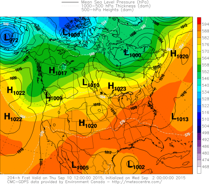
This is the 12zCMC on Day 10...1001mb Low in the BOC.


0 likes
The following post is NOT an official forecast and should not be used as such. It is just the opinion of the poster and may or may not be backed by sound meteorological data. It is NOT endorsed by any professional institution including storm2k.org For Official Information please refer to the NHC and NWS products.


Re: Re:
HurricaneFan wrote:gatorcane wrote:The global models from today are looking very bullish on another wave that is currently inside Africa. In fact this is the best agreement I have seen from the globals on any African wave so far this year. The ECMWF/GFS/GEM models are all showing development of this wave. I circled it below. It has noticeable spin with it already:
[]http://i.imgur.com/HIhGWca.gif[/img]
Any consensus with the models in terms of the track?It seems like the Wave in front of it will not recurve according to some models?
Is this expected to follow the same path as the Wave in front of it?
Good catch Gator. I was looking at that today. Good agreement. Even the CMC which has been tame this year is gung ho and has the strongest run.
0 likes
The following post is NOT an official forecast and should not be used as such. It is just the opinion of the poster and may or may not be backed by sound meteorological data. It is NOT endorsed by any professional institution including storm2k.org For Official Information please refer to the NHC and NWS products.
Barring something unexpected forming from the remnants of Erika just offshore the SE US by early next week, it is looking pretty quiet near the CONUS over the next 10+ days. However, once we get to near midmonth that's about the time analogs suggest starting to look for a possible threat or two to the Gulf, especially NE Gulf and especially late Sep-early Oct. It is highly doubtful that the CONUS will be threatened by any E MDR formation the rest of the season. Any gulf threat would very likely be from a genesis anywhere from just east of the Caribbean back to the Gulf, itself.
0 likes
Personal Forecast Disclaimer:
The posts in this forum are NOT official forecasts and should not be used as such. They are just the opinion of the poster and may or may not be backed by sound meteorological data. They are NOT endorsed by any professional institution or storm2k.org. For official information, please refer to the NHC and NWS products.
The posts in this forum are NOT official forecasts and should not be used as such. They are just the opinion of the poster and may or may not be backed by sound meteorological data. They are NOT endorsed by any professional institution or storm2k.org. For official information, please refer to the NHC and NWS products.
-
Rgv20
- S2K Supporter
- Posts: 2466
- Age: 39
- Joined: Wed Jan 05, 2011 5:42 pm
- Location: Edinburg/McAllen Tx
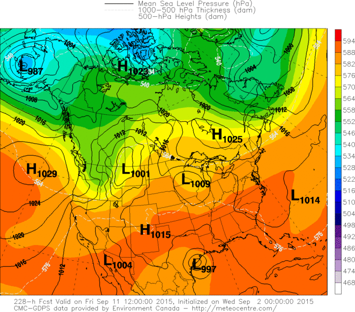
0zCMC still showing a GOM storm mid to late next week..


0 likes
The following post is NOT an official forecast and should not be used as such. It is just the opinion of the poster and may or may not be backed by sound meteorological data. It is NOT endorsed by any professional institution including storm2k.org For Official Information please refer to the NHC and NWS products.

Re:
LarryWx wrote:Barring something unexpected forming from the remnants of Erika just offshore the SE US by early next week, it is looking pretty quiet near the CONUS over the next 10+ days. However, once we get to near midmonth that's about the time analogs suggest starting to look for a possible threat or two to the Gulf, especially NE Gulf and especially late Sep-early Oct. It is highly doubtful that the CONUS will be threatened by any E MDR formation the rest of the season. Any gulf threat would very likely be from a genesis anywhere from just east of the Caribbean back to the Gulf, itself.
I doubt Erika's remnants will be able to do much back on the Atlantic side, with 20-30 knot winds in the upper levels forecasted to prevail over that area.
0 likes
Re: Re:
NDG wrote:LarryWx wrote:Barring something unexpected forming from the remnants of Erika just offshore the SE US by early next week, it is looking pretty quiet near the CONUS over the next 10+ days. However, once we get to near midmonth that's about the time analogs suggest starting to look for a possible threat or two to the Gulf, especially NE Gulf and especially late Sep-early Oct. It is highly doubtful that the CONUS will be threatened by any E MDR formation the rest of the season. Any gulf threat would very likely be from a genesis anywhere from just east of the Caribbean back to the Gulf, itself.
I doubt Erika's remnants will be able to do much back on the Atlantic side, with 20-30 knot winds in the upper levels forecasted to prevail over that area.
Agreed. That's why I said "barring something unexpected". I also mentioned in another post that the shear is projected to be too high to allow for more than a low chance for development off of the SE coast. Earlier GFS runs had had less shear thus allowing for a little bit higher chance. It might already be time to be thinking that the next nontrivial CONUS hit chance won't be til at least the 2nd half of Sep. from geneses in the western half of the Atlantic basin as seasonal pattern changes set in and quite possibly make that area more conducive.
0 likes
Personal Forecast Disclaimer:
The posts in this forum are NOT official forecasts and should not be used as such. They are just the opinion of the poster and may or may not be backed by sound meteorological data. They are NOT endorsed by any professional institution or storm2k.org. For official information, please refer to the NHC and NWS products.
The posts in this forum are NOT official forecasts and should not be used as such. They are just the opinion of the poster and may or may not be backed by sound meteorological data. They are NOT endorsed by any professional institution or storm2k.org. For official information, please refer to the NHC and NWS products.
-
stormlover2013
Re: 2015 Global model runs discussion
well gfs and euro have been hinting it but nothing consistent
0 likes
Re: 2015 Global model runs discussion
Looks to be some tumbleweed in the central Atlantic amplifying out of the ITCZ this morning. Any models showing support for development in this area? 
0 likes


-
Stormcenter
- S2K Supporter
- Posts: 6689
- Joined: Wed Sep 03, 2003 11:27 am
- Location: Houston, TX
-
stormlover2013
-
Rgv20
- S2K Supporter
- Posts: 2466
- Age: 39
- Joined: Wed Jan 05, 2011 5:42 pm
- Location: Edinburg/McAllen Tx
12zGFS nor non of its ensemble members develop anything in the BOC thru 10 days. CMC with the worst case scenario!
0 likes
The following post is NOT an official forecast and should not be used as such. It is just the opinion of the poster and may or may not be backed by sound meteorological data. It is NOT endorsed by any professional institution including storm2k.org For Official Information please refer to the NHC and NWS products.
-
emeraldislenc
- Category 2

- Posts: 601
- Joined: Fri Aug 24, 2012 4:49 pm
- Location: Emerald Isle NC
Re: 2015 Global model runs discussion
Everything looks quite for now. The next week looks very inactive. What are your thoughts?
0 likes
Who is online
Users browsing this forum: Category5Kaiju, wwizard and 266 guests