Here we go with the Eastern Atlantic Wave.
91L INVEST 150903 1800 10.6N 15.3W ATL 15 1010
Thread that was the topic for this wave at Talking Tropics forum.
viewtopic.php?f=31&t=117518
ATL: GRACE - Renmants - Discussion
Moderator: S2k Moderators
-
cycloneye

- Admin

- Posts: 149843
- Age: 69
- Joined: Thu Oct 10, 2002 10:54 am
- Location: San Juan, Puerto Rico
ATL: GRACE - Renmants - Discussion
0 likes
Visit the Caribbean-Central America Weather Thread where you can find at first post web cams,radars
and observations from Caribbean basin members Click Here
and observations from Caribbean basin members Click Here
-
AutoPenalti
- Category 5

- Posts: 4091
- Age: 29
- Joined: Mon Aug 17, 2015 4:16 pm
- Location: Ft. Lauderdale, Florida
Something to monitor, doesn't seem fishy.
0 likes
The posts in this forum are NOT official forecasts and should not be used as such. They are just the opinion of the poster and may or may not be backed by sound meteorological data. They are NOT endorsed by any professional institution or STORM2K. For official information, please refer to products from the NHC and NWS.
Model Runs Cheat Sheet:
GFS (5:30 AM/PM, 11:30 AM/PM)
HWRF, GFDL, UKMET, NAVGEM (6:30-8:00 AM/PM, 12:30-2:00 AM/PM)
ECMWF (1:45 AM/PM)
TCVN is a weighted averaged
-
cycloneye
- Admin
- Posts: 149843
- Age: 69
- Joined: Thu Oct 10, 2002 10:54 am
- Location: San Juan, Puerto Rico
Re: ATL: INVEST 91L - Discussion
A tropical wave located just offshore of the west coast of Africa is
producing a large area of showers and thunderstorms. This system has
the potential for some gradual development as it moves westward at
15 to 20 mph across the tropical Atlantic during the next few days.
* Formation chance through 48 hours...low...20 percent
* Formation chance through 5 days...medium...40 percent
0 likes
Visit the Caribbean-Central America Weather Thread where you can find at first post web cams,radars
and observations from Caribbean basin members Click Here
and observations from Caribbean basin members Click Here


Re: ATL: INVEST 91L - Discussion
Hey cycloneye, you forgot to include the link to the closed Talking Tropics thread for this system. For the benefit of those who want to know the history of 91L, here it is.cycloneye wrote:Here we go with the Eastern Atlantic Wave.
91L INVEST 150903 1800 10.6N 15.3W ATL 15 1010
0 likes
-
cycloneye
- Admin
- Posts: 149843
- Age: 69
- Joined: Thu Oct 10, 2002 10:54 am
- Location: San Juan, Puerto Rico
Re: ATL: INVEST 91L - Discussion
abajan wrote:Hey cycloneye, you forgot to include the link to the closed Talking Tropics thread for this system. For the benefit of those who want to know the history of 91L, here it is.cycloneye wrote:Here we go with the Eastern Atlantic Wave.
91L INVEST 150903 1800 10.6N 15.3W ATL 15 1010
Forgot that but is now at first post.Thank you for the reminder.
0 likes
Visit the Caribbean-Central America Weather Thread where you can find at first post web cams,radars
and observations from Caribbean basin members Click Here
and observations from Caribbean basin members Click Here
-
Gustywind

- Category 5
- Posts: 12334
- Joined: Mon Sep 03, 2007 7:29 am
- Location: Baie-Mahault, GUADELOUPE
TROPICAL WEATHER DISCUSSION
NWS NATIONAL HURRICANE CENTER MIAMI FL
805 PM EDT THU SEP 03 2015
A TROPICAL WAVE IS OVER WESTERN AFRICA WIT AXIS EXTENDING FROM
16N14W TO 08N14W...MOVING W AROUND 10 KT. THE WAVE COINCIDES
WITH 700 MB TROUGHING BETWEEN 10W-18W AND IS LARGELY LOW-
AMPLITUDE. ABUNDANT MOISTURE SURROUNDS THIS WAVE AND A LOW LEVEL
CIRCULATION IS TRYING TO DEVELOP. SCATTERED MODERATE CONVECTION
IS FROM 07N-15N BETWEEN 14W-20W.
0 likes


-
TropicalAnalystwx13

- Category 5
- Posts: 2109
- Age: 28
- Joined: Tue Jul 19, 2011 8:20 pm
- Location: Wilmington, NC
- Contact:
-
hurricanehunter69
- Category 1

- Posts: 344
- Joined: Sun May 16, 2010 5:21 pm
- Location: New Orleans
Re: ATL: INVEST 91L - Discussion
yep, we've got a vigorous and good looking wave with deep convection. low shear, decent thermodynamics and water temps. In short it's located in a proven breeding ground. So, I'm at a loss and trying to figure out why the models ( GFS in particular ) aren't more bullish on this? While I wouldn't bet on explosive development...I also would not be surprised. I'd lay odds on hurricane and would bet heavy on at least tropical storm.
0 likes
-
AutoPenalti
- Category 5
- Posts: 4091
- Age: 29
- Joined: Mon Aug 17, 2015 4:16 pm
- Location: Ft. Lauderdale, Florida
Re: ATL: INVEST 91L - Discussion
hurricanehunter69 wrote:yep, we've got a vigorous and good looking wave with deep convection. low shear, decent thermodynamics and water temps. In short it's located in a proven breeding ground. So, I'm at a loss and trying to figure out why the models ( GFS in particular ) aren't more bullish on this? While I wouldn't bet on explosive development...I also would not be surprised. I'd lay odds on hurricane and would bet heavy on at least tropical storm.
Ahead of it is a lot of dry air it seems, what is the ridge like for the next couple of days?
0 likes
The posts in this forum are NOT official forecasts and should not be used as such. They are just the opinion of the poster and may or may not be backed by sound meteorological data. They are NOT endorsed by any professional institution or STORM2K. For official information, please refer to products from the NHC and NWS.
Model Runs Cheat Sheet:
GFS (5:30 AM/PM, 11:30 AM/PM)
HWRF, GFDL, UKMET, NAVGEM (6:30-8:00 AM/PM, 12:30-2:00 AM/PM)
ECMWF (1:45 AM/PM)
TCVN is a weighted averaged
-
emeraldislenc
- Category 2

- Posts: 602
- Joined: Fri Aug 24, 2012 4:49 pm
- Location: Emerald Isle NC
-
emeraldislenc
- Category 2
- Posts: 602
- Joined: Fri Aug 24, 2012 4:49 pm
- Location: Emerald Isle NC
-
Riptide

- Category 2
- Posts: 753
- Age: 34
- Joined: Fri Jul 23, 2010 3:33 pm
- Location: Cape May, New Jersey
- Contact:
Re: ATL: INVEST 91L - Discussion
No joke, this is a sick (epic) African wave.
http://rammb.cira.colostate.edu/ramsdis/online/loop_meteosat.asp?data_folder=tropical/tropical_met_4km_visir2_floater&width=640&height=480&number_of_images_to_display=12
http://rammb.cira.colostate.edu/ramsdis/online/loop_meteosat.asp?data_folder=tropical/tropical_met_4km_visir2_floater&width=640&height=480&number_of_images_to_display=12
Last edited by tolakram on Fri Sep 04, 2015 6:33 am, edited 1 time in total.
Reason: added URL tags
Reason: added URL tags
0 likes
-
Extratropical94

- Professional-Met

- Posts: 3545
- Age: 31
- Joined: Wed Oct 20, 2010 6:36 am
- Location: Hamburg, Germany
- Contact:
Re: ATL: INVEST 91L - Discussion
emeraldislenc wrote:It looks healthy it was just bumped up to 60 percent.
Also short-term code orange.
A tropical wave located just offshore of the west coast of Africa is
producing a large area of showers and thunderstorms. This system
shows signs of organization and has the potential for some
development as it moves westward at 15 to 20 mph across the tropical
Atlantic during the next few days.
* Formation chance through 48 hours...medium...40 percent
* Formation chance through 5 days...medium...60 percent
0 likes
54° 11' 59'' N, 9° 9' 20'' E
Boomer Sooner!
Go Broncos! Go Cards!
Clinching counties, one at a time: https://mob-rule.com/user-gifs/USA/xtrp94.gif
- Daniel
Boomer Sooner!
Go Broncos! Go Cards!
Clinching counties, one at a time: https://mob-rule.com/user-gifs/USA/xtrp94.gif
- Daniel
-
emeraldislenc
- Category 2
- Posts: 602
- Joined: Fri Aug 24, 2012 4:49 pm
- Location: Emerald Isle NC

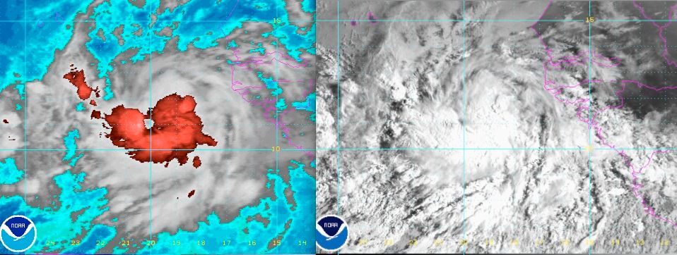
I would say based on cloud movement and backed up by ASCAT, the center appears to be near 11N/31W (roughly on the western edge of the convection) and it's still embedded in the ITCZ, quite elongated to the west.
None of the models aside from the GFS develops this and given the fact that it is likely less organized at the surface than satellite indicates, I think this is going to have very similar problems to Erika as far as organizing, and would not be surprised if it doesn't develop at all.
None of the models aside from the GFS develops this and given the fact that it is likely less organized at the surface than satellite indicates, I think this is going to have very similar problems to Erika as far as organizing, and would not be surprised if it doesn't develop at all.
0 likes
The above post is not official and should not be used as such. It is the opinion of the poster and may or may not be backed by sound meteorological data. It is not endorsed by any professional institution or storm2k.org. For official information, please refer to the NHC and NWS products.
-
beoumont

- Category 1
- Posts: 473
- Joined: Sun Jul 10, 2011 4:13 pm
- Location: East Central Florida
- Contact:
Re: ATL: INVEST 91L - Discussion
KAHUNA!!
1st light and jsl:
1st light and jsl:
Last edited by beoumont on Fri Sep 04, 2015 4:55 am, edited 1 time in total.
0 likes
List of 79 tropical cyclones intercepted by Richard Horodner:
http://www.canebeard.com/page/page/572246.htm
http://www.canebeard.com/page/page/572246.htm

Who is online
Users browsing this forum: No registered users and 36 guests