Texas Fall-2015

U.S. & Caribbean Weather Discussions and Severe Weather Events

Moderator: S2k Moderators

Forum rules

The posts in this forum are NOT official forecast and should not be used as such. They are just the opinion of the poster and may or may not be backed by sound meteorological data. They are NOT endorsed by any professional institution or STORM2K.

Help Support Storm2K
Message
Author
aggiecutter
Category 5
Category 5
Posts: 1753
Joined: Thu Oct 14, 2004 9:22 pm
Location: Texarkana

Re: Texas Fall-2015

#121 Postby aggiecutter » Tue Sep 08, 2015 12:37 pm

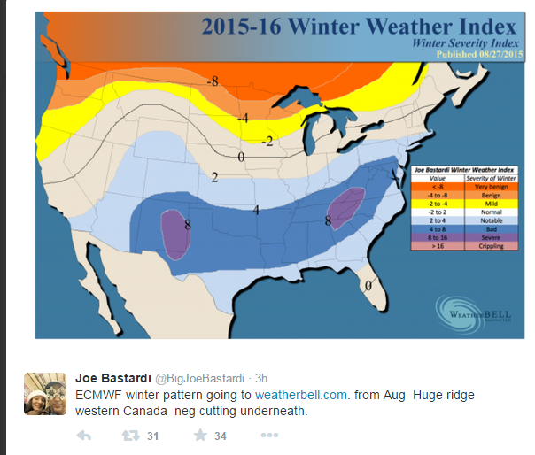
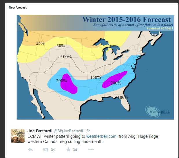
Weatherbell winter forecast(freebie). Looks like Dallas, Texarkana, Waco, Tyler, Round Rock, and Georgetown will experience significant amounts of ice and snow.


Image

Image
0 likes   

Brent
S2K Supporter
S2K Supporter
Posts: 38087
Age: 36
Joined: Sun May 16, 2004 10:30 pm
Location: Tulsa Oklahoma
Contact:

Re: Texas Fall-2015

#122 Postby Brent » Tue Sep 08, 2015 1:07 pm

wxman57 wrote: It's a sad time of year for a heat-mongerer...

http://home.comcast.net/~cgh57/iahgfs6zsep8.gif


It's about time. You had your fun. :P
0 likes   
#neversummer

User avatar
wxman57
Moderator-Pro Met
Moderator-Pro Met
Posts: 22977
Age: 67
Joined: Sat Jun 21, 2003 8:06 pm
Location: Houston, TX (southwest)

Re: Texas Fall-2015

#123 Postby wxman57 » Tue Sep 08, 2015 1:32 pm

Ideally, temperatures of 85 to 90 degrees are about perfect for a 3-5 hour bike ride. Below 85 and it can be a bit cool for a sleeveless jersey. Above 94-95 and it's not as comfortable riding in mid afternoon. If I'm not spending much of the day on my bike, i do like highs in the 70s for walking around (don't tell anyone).
0 likes   

User avatar
Tireman4
S2K Supporter
S2K Supporter
Posts: 5853
Age: 59
Joined: Fri Jun 30, 2006 1:08 pm
Location: Humble, Texas
Contact:

Re: Texas Fall-2015

#124 Postby Tireman4 » Tue Sep 08, 2015 1:44 pm

wxman57 wrote:Ideally, temperatures of 85 to 90 degrees are about perfect for a 3-5 hour bike ride. Below 85 and it can be a bit cool for a sleeveless jersey. Above 94-95 and it's not as comfortable riding in mid afternoon. If I'm not spending much of the day on my bike, i do like highs in the 70s for walking around (don't tell anyone).


Blasphemer...LOL..oh wait until your fans here you speak this way...the fans of the Heatmiser Fan Club will want to speak to you about this...LOL
0 likes   

Brent
S2K Supporter
S2K Supporter
Posts: 38087
Age: 36
Joined: Sun May 16, 2004 10:30 pm
Location: Tulsa Oklahoma
Contact:

Re: Texas Fall-2015

#125 Postby Brent » Tue Sep 08, 2015 3:08 pm

wxman57 wrote: i do like highs in the 70s for walking around (don't tell anyone).


ah ha... we're working on him. :P :lol:
0 likes   
#neversummer

User avatar
Texas Snowman
Storm2k Moderator
Storm2k Moderator
Posts: 6179
Joined: Fri Jan 25, 2008 11:29 am
Location: Denison, Texas

Re: Texas Fall-2015

#126 Postby Texas Snowman » Tue Sep 08, 2015 3:18 pm

wxman57 wrote:Ideally, temperatures of 85 to 90 degrees are about perfect for a 3-5 hour bike ride. Below 85 and it can be a bit cool for a sleeveless jersey. Above 94-95 and it's not as comfortable riding in mid afternoon. If I'm not spending much of the day on my bike, i do like highs in the 70s for walking around (don't tell anyone).


You know you love a good day in the low 30s with a stiff breeze blowing and snowflakes in the air.

Come on, admit it! We won't tell anyone, I promise!!! :D
0 likes   
The above post and any post by Texas Snowman is NOT an official forecast and should not be used as such. It is just the opinion of the poster and may or may not be backed by sound meteorological data. It is NOT endorsed by any professional institution including storm2k.org. For official information, please refer to NWS products.

User avatar
wxman57
Moderator-Pro Met
Moderator-Pro Met
Posts: 22977
Age: 67
Joined: Sat Jun 21, 2003 8:06 pm
Location: Houston, TX (southwest)

Re: Texas Fall-2015

#127 Postby wxman57 » Tue Sep 08, 2015 3:28 pm

OK, who's been posting under my login? I hate it when the temperature drops below 100F! ;-)
0 likes   

User avatar
Rgv20
S2K Supporter
S2K Supporter
Posts: 2466
Age: 38
Joined: Wed Jan 05, 2011 5:42 pm
Location: Edinburg/McAllen Tx

#128 Postby Rgv20 » Tue Sep 08, 2015 3:38 pm

.LONG TERM /THURSDAY THROUGH TUESDAY/...
H5 TROUGH REMAINS BOTTLED BETWEEN 2 RIDGES...WITH THE AXIS
REMAINING TO THE EAST ON THURSDAY. THIS WILL KEEP THE REGION ON
THE DRIER WEST SIDE THURSDAY AND INTO FRIDAY. FRIDAY BRINGS THE
TROUGH AXIS WESTWARD AS THE OVERALL TROUGH DEEPENS. AN INCREASE IN
MOISTURE FROM THE SOUTH WILL BEGIN TO RAMP UP POPS LATER FRIDAY
AFTERNOON. GOOD DEEP MOISTURE AND INSTABILITY COMBINES ON
SATURDAY FOR A GOOD CHANCES FOR SHOWERS AND THUNDERSTORMS. SUNDAY
INTO MONDAY A WEAK COLD FRONT TRIES TO MOVE SOUTHWARD INTO SOUTH
TEXAS. THE MAIN ISSUE IS SOUTHWARD MOVING DRIER AIR AND HOW FAR
SOUTH IT WILL REACH...CLASHING WITH GULF MOISTURE MOVING BACK TO
THE NORTH. CONTINUING WITH A GOOD CHANCE FOR THUNDERSTORMS BOTH
DAYS AS INSTABILITY REMAINS DECENT. QUESTION MARKS CROP UP
STARTING EARLY NEXT WEEK AS MODELS DIFFER ON WHAT HAPPENS TO THE
REMNANTS OF THE FRONT. NEEDLESS TO SAY...A DEGRADING FRONT
HOVERING IN THE WESTERN GULF NEEDS TO HAVE A CLOSE EYE KEPT ON IT.
FOR NOW...THE LOCALIZED INSTABILITY RAIN CHANCES CONTINUE TUESDAY
INTO WEDNESDAY...ESPECIALLY CLOSER TO THE COAST...AS WE MOVE INTO
OUR CLIMATOLOGICALLY WETTEST WEEK OF THE ENTIRE YEAR.
0 likes   
The following post is NOT an official forecast and should not be used as such. It is just the opinion of the poster and may or may not be backed by sound meteorological data. It is NOT endorsed by any professional institution including storm2k.org For Official Information please refer to the NHC and NWS products.

User avatar
Tireman4
S2K Supporter
S2K Supporter
Posts: 5853
Age: 59
Joined: Fri Jun 30, 2006 1:08 pm
Location: Humble, Texas
Contact:

Re: Texas Fall-2015

#129 Postby Tireman4 » Tue Sep 08, 2015 3:46 pm

wxman57 wrote:OK, who's been posting under my login? I hate it when the temperature drops below 100F! ;-)


Oh great, not this again..the Schizophrenic Wxman 57. That time in my life was just whacked out. Competing weather forecasts, toying with Porta, haunting me...I need to move...now...LOL
0 likes   

Brent
S2K Supporter
S2K Supporter
Posts: 38087
Age: 36
Joined: Sun May 16, 2004 10:30 pm
Location: Tulsa Oklahoma
Contact:

Re: Texas Fall-2015

#130 Postby Brent » Tue Sep 08, 2015 3:47 pm

FWD highlights

THE WEDNESDAY FRONT WILL NOT BRING A SIGNIFICANT DECREASE IN
TEMPERATURES...PARTICULARLY SOUTH OF THE I-20 CORRIDOR. BY
FRIDAY...HOWEVER...A STRONGER COLD FRONT WILL BE PUSHING ITS WAY
SOUTH INTO THE RED RIVER REGION AS A SHORTWAVE ROUNDS THE WESTERN
SIDE OF A DEEPENING EAST COAST TROUGH. ANOTHER CHANCE OF SHOWERS
AND STORMS WILL ACCOMPANY THIS SYSTEM FRIDAY...AND BY SATURDAY ALL
OF NORTH TEXAS SHOULD BE IN THE COOL AIR AS THE COLD FRONT PUSHES
SOUTH TOWARDS THE GULF COAST. OUR COOLEST CONDITIONS ARE EXPECTED
SATURDAY AND SUNDAY...WHEN LOWS IN THE 60S WILL FOLLOW HIGHS IN
THE LOWER 80S.
AN UPPER RIDGE SHOULD KEEP DRY CONDITIONS AND
SEASONAL TEMPERATURES IN PLACE SUNDAY THROUGH EARLY NEXT WEEK.

IT APPEARS THAT A FAIRLY ACTIVE PATTERN WILL REEMERGE BY THE
MIDDLE OF NEXT WEEK. RAIN CHANCES WILL LIKELY RETURN BY NEXT
WEDNESDAY AS AN UPPER LEVEL STORM SYSTEM DEEPENS OVER THE GREAT
BASIN AND HEADS EAST INTO THE PLAINS. THIS WOULD OCCUR JUST BEYOND
THIS FORECAST PACKAGE...BUT WILL LIKELY NEED TO BE ADDRESSED IN
FUTURE FORECASTS.

Saturday Night
Partly cloudy, with a low around 60.
0 likes   
#neversummer

User avatar
Ntxw
Storm2k Moderator
Storm2k Moderator
Posts: 22783
Joined: Wed Oct 21, 2009 6:34 pm
Location: DFW, Texas

#131 Postby Ntxw » Tue Sep 08, 2015 4:02 pm

And better yet, thunderstorms will accompany the front late tonight into early tomorrow morning. Been a good while since we've had one of those!
0 likes   
The above post and any post by Ntxw is NOT an official forecast and should not be used as such. It is just the opinion of the poster and may or may not be backed by sound meteorological data. It is NOT endorsed by any professional institution including Storm2k. For official information, please refer to NWS products.

  Help support Storm2K!
Help Support Storm2K

User avatar
vbhoutex
Storm2k Executive
Storm2k Executive
Posts: 29112
Age: 73
Joined: Wed Oct 09, 2002 11:31 pm
Location: Cypress, TX
Contact:

Re: Texas Fall-2015

#132 Postby vbhoutex » Tue Sep 08, 2015 10:28 pm

This is basically for SE TX and the middle TX coast. These is Jeff Lindner's latest email concerning the upcoming weather.
Upper level pattern is undergoing changes which will usher in an early season cold front across the area late this week.

Upper level ridge is sliding westward today with deepening downstream troughing developing over the central US. Powerful Hurricane Linda is moving NW off the west coast of Baja with its associated high level moisture clearly becoming entrained into the central US trough. Moisture levels will be on the increase on Wednesday as the frontal boundary approaches from the north. PWS will start the day in the 1.5-1.6 inch range and rise into the 2.0-2.1 inch range by early Thursday. Expect scattered showers and thunderstorms along the seabreeze mid late morning into the afternoon hours followed by more widespread and organized development later in the day in the College Station to Lake Livingston corridor.

Will see a decrease in convection Wednesday evening with the loss of heating, but likely not a complete loss of storms with the front seeping into the area. Thursday looks fairly active with short waves rotating across the area and an upper level low currently along the Louisiana coast moving W and inland over S TX. Factors will be in place for widespread storms with some threat for cell training along the frontal boundary. Very moist air mass will result in increasing rainfall rates. Front will only slowly cross the area awaiting a secondary push from an upstream trough late Friday so the area will remain under the threat for more storms Thursday night and Friday. Main threats will be heavy rainfall and high rainfall rates with some potential for flooding.

Weekend:

Front looks to clear the coast early Saturday with a significantly drier air mass moving in from the NNE. Dewpoints fall into the 50’s and 60’s on Saturday under NE winds and highs in the upper 80’s. Lows on Sunday morning will likely bottom out in the lower 60’s. The front will stall across the coastal waters over the weekend.

Early Next Week:

Highly uncertain and complicated forecast with potential for tropical cyclone formation over the western Gulf of Mexico.

Old frontal boundary will reside over the Gulf of Mexico early next week with most models in agreement on coastal troughing developing along the NE MX coast by Monday. The GFS maintains this trough in an elongated fashion into mid next week while slowly shifting it northward toward the mid TX coast…possibly closing off a 1008mb low near the coast around the middle of the week. The CMC develops a closed surface low over the Bay of Campeche in response to energy ejecting northward out of the eastern Pacific across MX. The ECMWF also forms a coastal trough, but quickly closes off a surface low and then rapidly deepens the system down to a 981mb hurricane as it tracks N then NE then ENE across the NW Gulf waters next week. The ECMWF solution is by far the most aggressive with respect to intensification. The ECMWF ensembles are starting to show development also in the western Gulf, but nowhere near the degree of the operational ECMWF.

There is enough model agreement and support to go with a coastal trough forming off the NE MX coast early next week and possibly closing off into a surface low pressure system. This line of thinking is in agreement with the latest HPC progs placing a “L” in the western Gulf. Think any tropical development will be slower than the ECMWF suggests given the very dry air mass lurking along the US Gulf coast which would likely become entrained into any circulation along with potential westerly wind shear…although the models are showing a general relaxing of the wind shear over the NW Gulf next week. For what it is worth strong warm phase ENSO years tend to favor Gulf of Mexico tropical cyclone formation and this can at times be fairly rapid.

Forecast is very uncertain for early next week with potential tropical development and any impacts along the TX coast. For now will go ahead and increase coastal winds as the pressure gradient increases out of high pressure to our NE and deepening low pressure to our SSW. This will produce a stiffening NE to ENE wind which is a favorable tidal pile-up wind for the upper TX coast due to Ekman transport (the movement of the water to the right of the mean wind direction). Will need to keep an eye on tides…even without any tropical formation as such long fetch gradient winds over time can bring higher than average tides.
0 likes   
Skywarn, C.E.R.T.
Please click below to donate to STORM2K to help with the expenses of keeping the site going:
Image

User avatar
Ntxw
Storm2k Moderator
Storm2k Moderator
Posts: 22783
Joined: Wed Oct 21, 2009 6:34 pm
Location: DFW, Texas

#133 Postby Ntxw » Wed Sep 09, 2015 4:13 am

Heavy rain this morning at DFW and quite the light/sound show. Airport picked up about an inch of rain

Low to mid 80s and crisp 60s at night this weekend...hallelujah.

Also ragweed has been high, some relief washing it out temporarily
0 likes   
The above post and any post by Ntxw is NOT an official forecast and should not be used as such. It is just the opinion of the poster and may or may not be backed by sound meteorological data. It is NOT endorsed by any professional institution including Storm2k. For official information, please refer to NWS products.


  Help support Storm2K!

Help Support Storm2K


gpsnowman
S2K Supporter
S2K Supporter
Posts: 3185
Joined: Fri Jan 07, 2011 10:35 am
Location: Grand Prairie Tx

#134 Postby gpsnowman » Wed Sep 09, 2015 4:14 am

Ahhhh yes. The drive on northbound 360 was a wet one. Heavy rain, thunder, lightning, and a north wind. What a scene. Finally, some weather to talk about.
0 likes   

User avatar
Ntxw
Storm2k Moderator
Storm2k Moderator
Posts: 22783
Joined: Wed Oct 21, 2009 6:34 pm
Location: DFW, Texas

#135 Postby Ntxw » Wed Sep 09, 2015 5:18 am

1.60 inches of rain at DFW this morning looks like final tally. That is more than all of July and August combined. Hopefully it is a sign of a wet fall to come. #ElNino
0 likes   
The above post and any post by Ntxw is NOT an official forecast and should not be used as such. It is just the opinion of the poster and may or may not be backed by sound meteorological data. It is NOT endorsed by any professional institution including Storm2k. For official information, please refer to NWS products.


  Help support Storm2K!

Help Support Storm2K


weatherdude1108
Category 5
Category 5
Posts: 4228
Joined: Tue Dec 13, 2011 1:04 pm
Location: Northwest Austin/Cedar Park, TX

#136 Postby weatherdude1108 » Wed Sep 09, 2015 6:33 am

6:30am - Watching the complex of rain enter the Colorado River basin north of Buchanan. Good spot to be!
:wink:
I am hoping it makes its way further down here to replenish my rain barrel and help my soil cracks and plants. Today is my watering day, but I didn't turn on the sprinklers, in excited anticipation of this event. I just hope I'm not wrong in turning off sprinklers this time (based on the historical infamous Austin bubble dome).
0 likes   

User avatar
Ntxw
Storm2k Moderator
Storm2k Moderator
Posts: 22783
Joined: Wed Oct 21, 2009 6:34 pm
Location: DFW, Texas

#137 Postby Ntxw » Wed Sep 09, 2015 7:51 am

Heavy rain again at DFW rush hour

The 1.65" this morning is a daily record, may get to 2" or close with this next batch. Avg rainfall for the month of Sept is 2.55"
0 likes   
The above post and any post by Ntxw is NOT an official forecast and should not be used as such. It is just the opinion of the poster and may or may not be backed by sound meteorological data. It is NOT endorsed by any professional institution including Storm2k. For official information, please refer to NWS products.


  Help support Storm2K!

Help Support Storm2K


User avatar
CaptinCrunch
S2K Supporter
S2K Supporter
Posts: 8728
Age: 57
Joined: Mon Nov 03, 2003 4:33 pm
Location: Kennedale, TX (Tarrant Co.)

#138 Postby CaptinCrunch » Wed Sep 09, 2015 8:01 am

It was a nice heavy rain this morning around 4am, had some thunder and lightening to go with it. Rain hard for about 45min then went to a light rain. sure glad to see it as is my lawn....lol
0 likes   

User avatar
CaptinCrunch
S2K Supporter
S2K Supporter
Posts: 8728
Age: 57
Joined: Mon Nov 03, 2003 4:33 pm
Location: Kennedale, TX (Tarrant Co.)

#139 Postby CaptinCrunch » Wed Sep 09, 2015 8:10 am

Looking toward Friday and the upcoming weekend.....

A STRONGER COLD FRONT ARRIVES INTO NORTH TEXAS LATE
FRIDAY INTO FRIDAY NIGHT. THIS FRONT WILL HAVE A COOLER AND DRIER
AIRMASS BEHIND IT THAN THE FIRST. ONCE THIS FRONT PUSHES THROUGH
THE AREA EARLY SATURDAY...RAIN CHANCES WILL COME TO AN END IN TIME
FOR THE WEEKEND. PLEASANTLY COOL LOW TEMPERATURES FROM THE UPPER
50S-MID 60S ARE EXPECTED EACH MORNING WITH HIGHS EXPECTED TO BE IN
THE LOWER TO MID 80S.
:ggreen:
0 likes   

User avatar
wxman57
Moderator-Pro Met
Moderator-Pro Met
Posts: 22977
Age: 67
Joined: Sat Jun 21, 2003 8:06 pm
Location: Houston, TX (southwest)

Re: Texas Fall-2015

#140 Postby wxman57 » Wed Sep 09, 2015 8:30 am

Here is a meteogram from the 6Z GFS. Looks like it's time to get your furnaces checked out before the frigid air arrives this weekend:

Image
0 likes   


Return to “USA & Caribbean Weather”

Who is online

Users browsing this forum: Brent and 4 guests