2015 Global model runs discussion
Moderator: S2k Moderators
Forum rules

The posts in this forum are NOT official forecasts and should not be used as such. They are just the opinion of the poster and may or may not be backed by sound meteorological data. They are NOT endorsed by any professional institution or STORM2K. For official information, please refer to products from the National Hurricane Center and National Weather Service.

Euro shows two more phantom storms originating from the MDR--It's already shown twice the amount than has actually occurred so I'm not biting. They should just downgrade it back and relieve it of being the utter joke it's become.
0 likes
The above post is not official and should not be used as such. It is the opinion of the poster and may or may not be backed by sound meteorological data. It is not endorsed by any professional institution or storm2k.org. For official information, please refer to the NHC and NWS products.
-
Stormcenter
- S2K Supporter

- Posts: 6689
- Joined: Wed Sep 03, 2003 11:27 am
- Location: Houston, TX
Re: 2015 Global model runs discussion
Early next week, wow that doesn't sound right time wise compared to what the models were saying yesterday. Oh well like I said yesterday. We have nothing now so we just wait and see, still too early IMO to just buy into what the models are saying.
wxman57 wrote:12Z Euro dropped the hurricane in the NW Gulf. Weak low moves inland into northern Mexico early next week. Same as the GFS.
0 likes
-
Tireman4

- S2K Supporter
- Posts: 5903
- Age: 60
- Joined: Fri Jun 30, 2006 1:08 pm
- Location: Humble, Texas
- Contact:
Re: 2015 Global model runs discussion
wxman57 wrote:12Z Euro dropped the hurricane in the NW Gulf. Weak low moves inland into northern Mexico early next week. Same as the GFS.
So that blew your forecast..he he
0 likes
-
gatorcane

- S2K Supporter
- Posts: 23708
- Age: 48
- Joined: Sun Mar 13, 2005 3:54 pm
- Location: Boca Raton, FL
Re:
Hammy wrote:Euro shows two more phantom storms originating from the MDR--It's already shown twice the amount than has actually occurred so I'm not biting. They should just downgrade it back and relieve it of being the utter joke it's become.
Low-latitude west runner too, 240 hours below. First MDR system recurves (the one the NHC is currently mentioning in their outlook) and that second one heads straight west.

0 likes


This is kind of strange. I was on NOLA.com and there was a picture of a red cone with the caption (something like) "NHC Has High Chance of Development" and has the cone bending from the BoC over toward the Texas Coast. I clicked on it and it went to a null story and it's not on their site anymore. I wonder if they jumped the gun or what. I did a search and can't find it now. Odd though.
0 likes
-
wxman57

- Moderator-Pro Met

- Posts: 23175
- Age: 68
- Joined: Sat Jun 21, 2003 8:06 pm
- Location: Houston, TX (southwest)
Re:
Steve wrote:This is kind of strange. I was on NOLA.com and there was a picture of a red cone with the caption (something like) "NHC Has High Chance of Development" and has the cone bending from the BoC over toward the Texas Coast. I clicked on it and it went to a null story and it's not on their site anymore. I wonder if they jumped the gun or what. I did a search and can't find it now. Odd though.
It may have been a cached web page on former TS Bill.
0 likes
-
Rgv20

- S2K Supporter
- Posts: 2466
- Age: 39
- Joined: Wed Jan 05, 2011 5:42 pm
- Location: Edinburg/McAllen Tx
Re: 2015 Global model runs discussion
NWS Brownsville afternoon discussion
TROPICAL...BOTH THE GFS AND ECMWF MAINTAIN LOW PRESSURE IN
THE SOUTHWEST GULF THROUGH THE WEEKEND...DRIFTING A WEAK
CIRCULATION NORTH ALONG THE MEXICAN COAST TOWARD BROWNSVILLE BY
TUESDAY...WHERE IT WILL REMAIN IDENTIFIABLE AS A FEATURE.
CMC aka Canadian Global Model
TROPICAL...BOTH THE GFS AND ECMWF MAINTAIN LOW PRESSURE IN
THE SOUTHWEST GULF THROUGH THE WEEKEND...DRIFTING A WEAK
CIRCULATION NORTH ALONG THE MEXICAN COAST TOWARD BROWNSVILLE BY
TUESDAY...WHERE IT WILL REMAIN IDENTIFIABLE AS A FEATURE.
stormlover2013 wrote:What's the ggem model?
CMC aka Canadian Global Model
0 likes
The following post is NOT an official forecast and should not be used as such. It is just the opinion of the poster and may or may not be backed by sound meteorological data. It is NOT endorsed by any professional institution including storm2k.org For Official Information please refer to the NHC and NWS products.


Re:
Steve wrote:This is kind of strange. I was on NOLA.com and there was a picture of a red cone with the caption (something like) "NHC Has High Chance of Development" and has the cone bending from the BoC over toward the Texas Coast. I clicked on it and it went to a null story and it's not on their site anymore. I wonder if they jumped the gun or what. I did a search and can't find it now. Odd though.
Steve, I know what you're talking about because I clicked on it yesterday. It was an article about TS Bill (dated from June) that they probably took down because logically people were complaining about it still popping up.
0 likes
Re: 2015 Global model runs discussion
Thanks guys. That must have been it. I was kind of surprised to see the graphics since we would probably be 5ish days out from Genesis anyway. Still thinking there is a shot with that pattern reversal, but I'm grateful I'm not staring down the barrel of a cat 2 or 3 next week with a weaker more westerly solution seeming to take hold. I love storms like everyone else here, but I didn't need what the Euro was serving up.
0 likes
-
Hurricaneman

- Category 5

- Posts: 7404
- Age: 45
- Joined: Tue Aug 31, 2004 3:24 pm
- Location: central florida
Re: 2015 Global model runs discussion
The GFS seems to develop that wave at 37W near the Bahamas at or around 8 days which may or may not happen but to some degree around the same timeframe the Euro seems to have a sharp wave in the same general area so it may be something to keep an eye on even if it does nothing
The posts in this forum are NOT official forecast and should not be used as such. They are just the opinion of the poster and may or may not be backed by sound meteorological data. They are NOT endorsed by any professional institution or storm2k.org. For official information, please refer to the NHC and NWS products
The posts in this forum are NOT official forecast and should not be used as such. They are just the opinion of the poster and may or may not be backed by sound meteorological data. They are NOT endorsed by any professional institution or storm2k.org. For official information, please refer to the NHC and NWS products
0 likes
-
Andrew92

- S2K Supporter
- Posts: 3247
- Age: 42
- Joined: Mon Jun 16, 2003 12:35 am
- Location: Phoenix, Arizona
Re: MODEL BOB CYCLONE.
spiral wrote:[img]Model spins a cyclone up moves nw over the BOB landfalls India.
If it occurs, Chapala is the next name for those curious. Hope this doesn't take place though, India took it tough with Hudhud last year, don't want another storm remotely like that one.
-Andrew92
0 likes

-
Stormcenter
- S2K Supporter
- Posts: 6689
- Joined: Wed Sep 03, 2003 11:27 am
- Location: Houston, TX
Re:
Please share with us.
Alyono wrote:the Canadian is trying to reclaim its wishcatsing crown from the EC. The 0Z run is really entertaining. Cannot help but laugh at it
the only legit storm is the one it is showing east of the islands
0 likes
Re: 2015 Global model runs discussion
Euro flipped from having a major hurricane to nothing in only two runs, given it's history the rest of the season (and this being the third phantom major) I think it's runs can pretty much be ignored beyond 72 hours.
edit: Euro/GFS/GEM all seem to be showing a system at day 5-6 being weak, turning north, and then strengthening over open waters. If this plays out it could be our long-tracker of the season. Seems to be from the highlighted system.
edit: Euro/GFS/GEM all seem to be showing a system at day 5-6 being weak, turning north, and then strengthening over open waters. If this plays out it could be our long-tracker of the season. Seems to be from the highlighted system.
Last edited by Hammy on Fri Sep 11, 2015 3:28 am, edited 1 time in total.
0 likes
The above post is not official and should not be used as such. It is the opinion of the poster and may or may not be backed by sound meteorological data. It is not endorsed by any professional institution or storm2k.org. For official information, please refer to the NHC and NWS products.
2) Alyono, don't laugh but it looks to me like the "who knows what" on the 0Z FRI CMC that goes on to threaten NC/VA 9/19-20 is a redevelopment from Grace's remnants! It is easy to see this by following the 500 mb vorticity and even easier to see by following the 700 mb vorticity at 6 hour intervals. Instead of it getting turned west into and past FL into the GOM, it remains E of FL meandering well offshore the SE 9/15-7 before starting a northward move 9/18. It can also be seen on the 850 mb vorticity maps.
Follow the 700 mb vorticity:
http://www.tropicaltidbits.com/analysis ... 0&ypos=205
0 likes
Personal Forecast Disclaimer:
The posts in this forum are NOT official forecasts and should not be used as such. They are just the opinion of the poster and may or may not be backed by sound meteorological data. They are NOT endorsed by any professional institution or storm2k.org. For official information, please refer to the NHC and NWS products.
The posts in this forum are NOT official forecasts and should not be used as such. They are just the opinion of the poster and may or may not be backed by sound meteorological data. They are NOT endorsed by any professional institution or storm2k.org. For official information, please refer to the NHC and NWS products.
-
OuterBanker
- S2K Supporter
- Posts: 1761
- Joined: Wed Feb 26, 2003 10:53 am
- Location: Nags Head, NC
- Contact:
Re:
LarryWx wrote::uarrow: 1) Hammy, That sounds like sound advice.
2) Alyono, don't laugh but it looks to me like the "who knows what" on the 0Z FRI CMC that goes on to threaten NC/VA 9/19-20 is a redevelopment from Grace's remnants! It is easy to see this by following the 500 mb vorticity and even easier to see by following the 700 mb vorticity at 6 hour intervals. Instead of it getting turned west into and past FL into the GOM, it remains E of FL meandering well offshore the SE 9/15-7 before starting a northward move 9/18. It can also be seen on the 850 mb vorticity maps.
Follow the 700 mb vorticity:
http://www.tropicaltidbits.com/analysis ... 0&ypos=205
Lol, the 850 is even more entertaining. I was starting to worry about the CMC, after their upgrade the phantoms were cut way back. Nice to see some wild things from the CMC again. Looks like it will be the only entertainment we will have this year.
What a weird movement at the end. Quite impossible but very entertaining.
0 likes
-
tropicwatch

- Category 5
- Posts: 3426
- Age: 62
- Joined: Sat Jun 02, 2007 10:01 am
- Location: The Villages, Florida
- Contact:
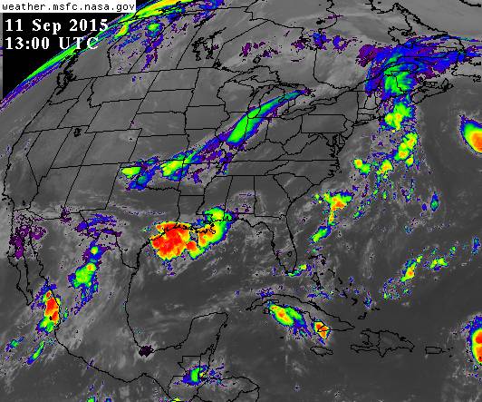
This mess coming off of Texas entering the gulf, could this be what the euro was picking up for this weekend?
0 likes
Tropicwatch
Agnes 72', Eloise 75, Elena 85', Kate 85', Charley 86', Florence 88', Beryl 94', Dean 95', Erin 95', Opal 95', Earl 98', Georges 98', Ivan 2004', Arlene 2005', Dennis 2005', Ida 2009' Debby 2012' Irma 2017' Michael 2018'
Agnes 72', Eloise 75, Elena 85', Kate 85', Charley 86', Florence 88', Beryl 94', Dean 95', Erin 95', Opal 95', Earl 98', Georges 98', Ivan 2004', Arlene 2005', Dennis 2005', Ida 2009' Debby 2012' Irma 2017' Michael 2018'
Who is online
Users browsing this forum: cycloneye and 318 guests