GOM looks messy (Is Invest 94L)

This is the general tropical discussion area. Anyone can take their shot at predicting a storms path.

Moderator: S2k Moderators

Forum rules

The posts in this forum are NOT official forecasts and should not be used as such. They are just the opinion of the poster and may or may not be backed by sound meteorological data. They are NOT endorsed by any professional institution or STORM2K. For official information, please refer to products from the National Hurricane Center and National Weather Service.

Help Support Storm2K
Message
Author
rockyman
Category 5
Category 5
Posts: 1967
Joined: Thu Jun 26, 2003 12:24 pm
Location: Dauphin Island, AL

Re: GOM looks messy

#61 Postby rockyman » Sat Sep 12, 2015 7:56 pm

The area just off the NE Mexican coastline looks somewhat interesting tonight.

http://earth.nullschool.net/#current/wind/surface/level/overlay=total_precipitable_water/orthographic=-99.45,22.32,2048

Image

850 vorticity:
Image
0 likes   

User avatar
gatorcane
S2K Supporter
S2K Supporter
Posts: 23689
Age: 47
Joined: Sun Mar 13, 2005 3:54 pm
Location: Boca Raton, FL

Re:

#62 Postby gatorcane » Sat Sep 12, 2015 9:39 pm

spiral wrote:Yeah and looks to be drifting ESE kinda odd its getting no attention its right under everyone's noses but it seems they are all looking at waves off Africa atm thousands of miles away, i'm not understanding that lodgic. :wink:


There is around 50K of shear over it with zero model support.
0 likes   

CYCLONE MIKE
Category 5
Category 5
Posts: 2183
Joined: Tue Aug 31, 2004 6:04 pm
Location: Gonzales, LA

Re: GOM looks messy

#63 Postby CYCLONE MIKE » Sat Sep 12, 2015 10:05 pm

spiral wrote:Yeah and looks to be drifting ESE kinda odd its getting no attention its right under everyone's noses but it seems they are all looking at waves off Africa atm thousands of miles away, i'm not understanding that lodgic. :wink:

That's because there is nothing worth getting any attention. Just a few storms in the gulf with tons of shear.

Even the last few gfs runs have cut our precip totals to much of nothing for the next 10 days.
Last edited by CYCLONE MIKE on Sat Sep 12, 2015 10:13 pm, edited 1 time in total.
0 likes   

User avatar
NDG
S2K Supporter
S2K Supporter
Posts: 15445
Joined: Sun Jul 09, 2006 10:14 pm
Location: Orlando, FL

Re: GOM looks messy

#64 Postby NDG » Sat Sep 12, 2015 10:55 pm

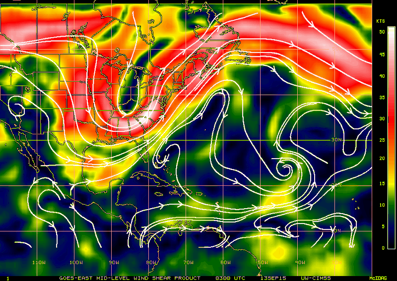
Shear is continuing to increase across the BOC, but even more disruptive to anything trying to form on the tail end of the frontal boundary is the westerly mid level shear. Far Eastern Atlantic is the only area with better UL conditions.

Image
0 likes   

rockyman
Category 5
Category 5
Posts: 1967
Joined: Thu Jun 26, 2003 12:24 pm
Location: Dauphin Island, AL

Re: GOM looks messy

#65 Postby rockyman » Sun Sep 13, 2015 9:08 am

Levi is watching:

https://twitter.com/TropicalTidbits/sta ... 3674990592

Convection is strong:
Image
Last edited by rockyman on Sun Sep 13, 2015 9:10 am, edited 2 times in total.
0 likes   

Dean4Storms
S2K Supporter
S2K Supporter
Posts: 6358
Age: 62
Joined: Sun Aug 31, 2003 1:01 pm
Location: Miramar Bch. FL

#66 Postby Dean4Storms » Sun Sep 13, 2015 9:08 am

Convection down there is really raging this morning, if it wasn't for the shear! Boom!
0 likes   

rockyman
Category 5
Category 5
Posts: 1967
Joined: Thu Jun 26, 2003 12:24 pm
Location: Dauphin Island, AL

#67 Postby rockyman » Sun Sep 13, 2015 9:11 am

Watching satellite loops, strong shear is evident across the northern half of the convective mass, but shear is much lower over the southern half of the mass.
0 likes   

User avatar
northjaxpro
S2K Supporter
S2K Supporter
Posts: 8900
Joined: Mon Sep 27, 2010 11:21 am
Location: Jacksonville, FL

#68 Postby northjaxpro » Sun Sep 13, 2015 9:30 am

:uarrow:

Shear is entirely too strong for development down there in the Bay of Campeche for at least from now through the next couple of days. However, if vorticity can linger down in that region heading into the latter portions of this week, then it may be possible for a bit better environment with reduced shear.

Conditions may get better as the week progresses and the BOC region may need to be watched. Right now, at least in the next 72 hours, virtually no chance for tropical cyclone development!
0 likes   
NEVER, EVER SAY NEVER in the tropics and weather in general, and most importantly, with life itself!!

________________________________________________________________________________________

Fay 2008 Beryl 2012 Debby 2012 Colin 2016 Hermine 2016 Julia 2016 Matthew 2016 Irma 2017 Dorian 2019

User avatar
perk
Category 3
Category 3
Posts: 825
Joined: Mon Aug 09, 2004 9:35 am
Location: Richmond Texas

Re:

#69 Postby perk » Sun Sep 13, 2015 10:10 am

northjaxpro wrote::uarrow:

Shear is entirely too strong for development down there in the Bay of Campeche for at least from now through the next couple of days. However, if vorticity can linger down in that region heading into the latter portions of this week, then it may be possible for a bit better environment with reduced shear.

Conditions may get better as the week progresses and the BOC region may need to be watched. Right now, at least in the next 72 hours, virtually no chance for tropical cyclone development!


That shear will probably relax when that front lifts out.
0 likes   

LarryWx
Category 5
Category 5
Posts: 6246
Joined: Sun Sep 07, 2003 2:04 pm
Location: GA

#70 Postby LarryWx » Sun Sep 13, 2015 10:34 am

:uarrow: Northjax/perk,
Looking at model consensus, I think that the best shot at TC genesis in the entire GOM this week will come NE of there as most of the remnant vorticity from Grace moves WNW into the GOM & possibly interacts with the old frontal related moisture. The 0Z Euro now has a weak closed sfc low forming 9/17 in the middle of the Gulf and sitting for about three days, a period during which shear will have weakened considerably from the current very strong levels and may not be that strong or strong at all by then. A sfc low forming and sitting over very warm water to the SW of a large nearly stationary and warming sfc high (in this case centered over the US MidAtlantic states) is actually not all that rare. It is a relatively favorable setup for sfc low genesis due to low level convergence of warm air inducing rising air below the high and possibly inducing sfc low genesis. Other models have had sfc low pressure forming near there around that time.
I still think the chances of TC genesis there are low but they may rise in my mind soon if future Euro runs and other models start picking up on this more. I expect this area toward the middle of the Gulf to start getting more attention by mid week and this could at least become an Invest around then.
Other opinions about this?
Last edited by LarryWx on Sun Sep 13, 2015 10:52 am, edited 6 times in total.
0 likes   
Personal Forecast Disclaimer:
The posts in this forum are NOT official forecasts and should not be used as such. They are just the opinion of the poster and may or may not be backed by sound meteorological data. They are NOT endorsed by any professional institution or storm2k.org. For official information, please refer to the NHC and NWS products.

User avatar
Hurricaneman
Category 5
Category 5
Posts: 7349
Age: 44
Joined: Tue Aug 31, 2004 3:24 pm
Location: central florida

Re: GOM looks messy

#71 Postby Hurricaneman » Sun Sep 13, 2015 10:37 am

There is a LLC it looks like at 22.5N 97.2W
0 likes   

User avatar
TropicalAnalystwx13
Category 5
Category 5
Posts: 2109
Age: 27
Joined: Tue Jul 19, 2011 8:20 pm
Location: Wilmington, NC
Contact:

#72 Postby TropicalAnalystwx13 » Sun Sep 13, 2015 11:24 am

The NHC should highlight this, even if they only give it a 20%/20% shot at development. Shear is obviously unfavorable now, but there are already signs of a developing surface low, and the GFS upper-air forecast shows some semblance of anticyclonic flow developing before the disturbance moves ashore Mexico late Tuesday.
0 likes   

User avatar
Hurricaneman
Category 5
Category 5
Posts: 7349
Age: 44
Joined: Tue Aug 31, 2004 3:24 pm
Location: central florida

Re: GOM looks messy

#73 Postby Hurricaneman » Sun Sep 13, 2015 11:36 am

This is 94L
0 likes   

TheStormExpert

#74 Postby TheStormExpert » Sun Sep 13, 2015 11:40 am

Wow! :eek: Second invest in about a week or so where an area becomes an invest before the NHC mentions it in their TWO's.
0 likes   

User avatar
Hurricaneman
Category 5
Category 5
Posts: 7349
Age: 44
Joined: Tue Aug 31, 2004 3:24 pm
Location: central florida

Re:

#75 Postby Hurricaneman » Sun Sep 13, 2015 11:42 am

TheStormExpert wrote:Wow! :eek: Second invest in about a week or so where an area becomes an invest before the NHC mentions it in their TWO's.


sometimes things come together quick and there is a clear LLC down there seemed as though as someone mentioned last night that a LLC was coming together and voila
0 likes   

User avatar
Extratropical94
Professional-Met
Professional-Met
Posts: 3538
Age: 30
Joined: Wed Oct 20, 2010 6:36 am
Location: Hamburg, Germany
Contact:

#76 Postby Extratropical94 » Sun Sep 13, 2015 11:46 am

Thread can be closed.

Continue here: viewtopic.php?f=59&t=117556
0 likes   
54° 11' 59'' N, 9° 9' 20'' E
Boomer Sooner!
Go Broncos! Go Cards! Go Niners!
- Daniel

LarryWx
Category 5
Category 5
Posts: 6246
Joined: Sun Sep 07, 2003 2:04 pm
Location: GA

Re:

#77 Postby LarryWx » Sun Sep 13, 2015 11:59 am

Extratropical94 wrote:Thread can be closed.

Continue here: viewtopic.php?f=59&t=117556


Maybe this thread will be closed, but keep in mind that this thread has been used for various Gulf entities over the last 10 days as opposed to just the current SW Gulf area. If this is closed, we could just create a new general Gulf thread.
0 likes   
Personal Forecast Disclaimer:
The posts in this forum are NOT official forecasts and should not be used as such. They are just the opinion of the poster and may or may not be backed by sound meteorological data. They are NOT endorsed by any professional institution or storm2k.org. For official information, please refer to the NHC and NWS products.


Return to “Talkin' Tropics”

Who is online

Users browsing this forum: duilaslol and 1026 guests