This is former Invest 90E.
Link to old thread: viewtopic.php?f=59&t=117552
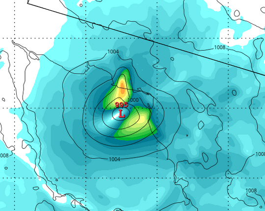
91E INVEST 150918 1200 18.0N 110.0W EPAC 20 1007
An elongated surface trough extends several hundred miles off the
west-central coast of Mexico. Showers and thunderstorms associated
with this system have increased over the past 24 hours, and a more
well-defined surface circulation is developing within this trough
about 350 miles south of the southern tip of the Baja California
peninsula. Some additional development of this system is possible
through this weekend while it moves generally northwestward at 5 to
10 mph. After that time, colder water and stronger upper-level
winds near the Baja California peninsula should limit development.
* Formation chance through 48 hours...low...30 percent
* Formation chance through 5 days...low...30 percent
EPAC: SIXTEEN-E - Remnants
Moderator: S2k Moderators
-
Extratropical94

- Professional-Met

- Posts: 3545
- Age: 31
- Joined: Wed Oct 20, 2010 6:36 am
- Location: Hamburg, Germany
- Contact:
EPAC: SIXTEEN-E - Remnants
0 likes
54° 11' 59'' N, 9° 9' 20'' E
Boomer Sooner!
Go Broncos! Go Cards!
Clinching counties, one at a time: https://mob-rule.com/user-gifs/USA/xtrp94.gif
- Daniel
Boomer Sooner!
Go Broncos! Go Cards!
Clinching counties, one at a time: https://mob-rule.com/user-gifs/USA/xtrp94.gif
- Daniel
-
Yellow Evan

- Professional-Met
- Posts: 16257
- Age: 27
- Joined: Fri Jul 15, 2011 12:48 pm
- Location: Henderson, Nevada/Honolulu, HI
- Contact:
Race against time
Code: Select all
                    * EAST PACIFIC SHIPS INTENSITY FORECAST          *
                    * IR SAT DATA AVAILABLE,       OHC AVAILABLE     *
                    *  INVEST      EP912015  09/18/15  12 UTC        *

TIME (HR)          0     6    12    18    24    36    48    60    72    84    96   108   120
V (KT) NO LAND    20    21    21    22    23    25    25    25    23    18   DIS   DIS   DIS
V (KT) LAND       20    21    21    22    23    25    25    25    23    20   DIS   DIS   DIS
V (KT) LGE mod    20    20    20    21    21    21    20    18    17    17    23    26    28
Storm Type      TROP  TROP  TROP  TROP  TROP  TROP  TROP  TROP  TROP  TROP  TROP  TROP  EXTP

SHEAR (KT)        11     8     6     3     8     7    14    25    33    35    46    43    54
SHEAR ADJ (KT)    -3    -4    -2     0    -4    -2     2    -1     0     1    -4    -1    -6
SHEAR DIR         51    50    59    30   336   316   257   230   218   203   209   213   226
SST (C)         29.4  29.2  29.1  28.8  28.6  27.5  26.2  25.6  23.4  31.5  23.0  20.3  19.3
POT. INT. (KT)   157   155   154   151   150   139   126   121    98   173    94    66    63
200 MB T (C)   -51.3 -51.1 -50.7 -50.9 -51.0 -50.8 -51.0 -51.0 -51.7 -52.0 -52.7 -53.6 -55.0
TH_E DEV (C)       7     8     8     7     7     6     5     5     3     5     4     7     4
700-500 MB RH     81    78    76    75    75    71    69    66    66    64    61    61    64
MODEL VTX (KT)    10    10    10    10     9     8     6     6     6     5     3     4     3
850 MB ENV VOR    15    20    28    31    24    22    15    14    23     8    30    73    64
200 MB DIV        32    34    49    30    16    45    44    52    54    97    55    85    85
700-850 TADV       0     0    -1     0     0     0     2     6     2     4     0    -8     0
LAND (KM)        524   508   478   446   426   393   270   144    53    17  -292  -639  -999
LAT (DEG N)     18.0  18.4  18.7  19.2  19.6  21.1  23.1  25.8  28.5  31.4  34.1  37.1  39.8
LONG(DEG W)    110.0 110.5 111.0 111.6 112.1 113.3 114.2 114.6 114.8 114.4 113.5 112.0 109.3
STM SPEED (KT)     7     6     7     7     8    10    12    14    14    14    15    17    17
HEAT CONTENT      26    19    15    12     8     4     8     1     0    16     0     0     0

  FORECAST TRACK FROM BAMM      INITIAL HEADING/SPEED (DEG/KT):305/  7      CX,CY:  -5/  4
  T-12 MAX WIND:  15            PRESSURE OF STEERING LEVEL (MB):  515  (MEAN=581)
  GOES IR BRIGHTNESS TEMP. STD DEV.  50-200 KM RAD:  22.1 (MEAN=14.5)
  % GOES IR PIXELS WITH T < -20 C    50-200 KM RAD:  46.0 (MEAN=65.0)

                        INDIVIDUAL CONTRIBUTIONS TO INTENSITY CHANGE
                         6   12   18   24   36   48   60   72   84   96  108  120
                        ----------------------------------------------------------
  SAMPLE MEAN CHANGE     0.   0.   0.   1.   1.   1.   0.   0.  -1.  -1.  -2.  -2.
  SST POTENTIAL          0.   0.   0.   2.   8.  14.  20.  24.  29.  31.  29.  26.
  VERTICAL SHEAR MAG     1.   2.   3.   5.   7.   7.   5.   0.  -8. -17. -24. -33.
  VERTICAL SHEAR ADJ     0.   1.   1.   1.   2.   1.   1.   1.   1.   1.   2.   2.
  VERTICAL SHEAR DIR     0.   0.   0.   0.   0.   1.   2.   4.   5.   6.   7.   7.
  PERSISTENCE            0.   0.   0.  -1.  -1.  -1.  -1.  -1.  -1.  -1.   0.   0.
  200/250 MB TEMP.       0.  -1.  -2.  -3.  -6.  -7.  -9.  -9.  -9.  -8.  -6.  -3.
  THETA_E EXCESS         0.   0.   0.   0.  -1.  -2.  -3.  -4.  -5.  -6.  -7.  -7.
  700-500 MB RH          0.   1.   1.   1.   2.   3.   3.   3.   4.   4.   4.   4.
  MODEL VTX TENDENCY     0.   0.  -1.  -1.  -2.  -5.  -6.  -6.  -7. -10.  -9. -10.
  850 MB ENV VORTICITY   0.   0.   0.   0.   0.   0.   0.   0.   0.   0.   0.   1.
  200 MB DIVERGENCE      0.   0.   0.   0.   1.   1.   1.   1.   0.   0.  -1.  -2.
  850-700 T ADVEC        0.   0.   0.   0.   0.   0.   0.   0.   0.   0.   0.   1.
  ZONAL STORM MOTION     0.   0.   0.   0.  -1.  -1.  -1.  -1.  -1.  -1.  -1.  -1.
  STEERING LEVEL PRES    0.   0.   0.   0.   0.  -1.  -1.  -1.  -1.  -1.  -1.  -1.
  DAYS FROM CLIM. PEAK   0.   0.   0.   0.   0.   0.   0.   0.   0.   0.   0.   0.
  GOES PREDICTORS        0.   0.  -1.  -1.  -2.  -4.  -6.  -6.  -7.  -8.  -8.  -8.
  OCEAN HEAT CONTENT     0.   0.   0.   0.  -1.  -1.  -1.  -1.  -1.  -1.  -1.  -1.
                        ----------------------------------------------------------
  TOTAL CHANGE           1.   1.   2.   3.   5.   5.   5.   3.  -2. -11. -17. -26.

   ** 2013 E. Pacific RI INDEX EP912015 INVEST     09/18/15  12 UTC **
           ( 30 KT OR MORE MAX WIND INCREASE IN NEXT 24 HR)

 12 HR PERSISTENCE (KT):   0.0 Range:-22.0 to  38.5 Scaled/Wgted Val:  0.4/  0.8
 850-200 MB SHEAR (KT) :   7.2 Range: 18.7 to   1.4 Scaled/Wgted Val:  0.7/  1.0
 POT = MPI-VMAX (KT)   : 133.5 Range: 40.3 to 141.7 Scaled/Wgted Val:  0.9/  1.0
 STD DEV OF IR BR TEMP :  22.1 Range: 38.9 to   2.4 Scaled/Wgted Val:  0.5/  0.5
 Heat content (KJ/cm2) :  16.0 Range:  3.6 to  75.9 Scaled/Wgted Val:  0.2/  0.1
 D200 (10**7s-1)       :  32.2 Range:-11.0 to 135.3 Scaled/Wgted Val:  0.3/  0.2
 % area w/pixels <-30 C:  37.0 Range: 41.4 to 100.0 Scaled/Wgted Val:  0.0/  0.0
 850-700 MB REL HUM (%):  75.0 Range: 57.6 to  96.8 Scaled/Wgted Val:  0.4/ -0.1

 Prob of RI for 25 kt RI threshold=    28% is   2.2 times the sample mean(13.1%)
 Prob of RI for 30 kt RI threshold=     3% is   0.3 times the sample mean( 8.7%)
 Prob of RI for 35 kt RI threshold=     2% is   0.3 times the sample mean( 6.0%)
 Prob of RI for 40 kt RI threshold=     1% is   0.3 times the sample mean( 4.3%)
0 likes
-
Extratropical94
- Professional-Met
- Posts: 3545
- Age: 31
- Joined: Wed Oct 20, 2010 6:36 am
- Location: Hamburg, Germany
- Contact:
An area of low pressure is centered about 350 miles south of the
southern tip of the Baja California peninsula. Showers and
thunderstorms have been increasing near the low, and environmental
conditions appear conducive for some additional development through
the weekend while the system moves northwestward or north-
northwestward at 5 to 10 mph. After that time, colder water and
strong upper-level winds should limit development. Regardless of
development, heavy rains and flash flooding are possible across
portions of the Baja California peninsula and northwestern mainland
Mexico through the weekend.
* Formation chance through 48 hours...medium...40 percent
* Formation chance through 5 days...medium...40 percent
0 likes
54° 11' 59'' N, 9° 9' 20'' E
Boomer Sooner!
Go Broncos! Go Cards!
Clinching counties, one at a time: https://mob-rule.com/user-gifs/USA/xtrp94.gif
- Daniel
Boomer Sooner!
Go Broncos! Go Cards!
Clinching counties, one at a time: https://mob-rule.com/user-gifs/USA/xtrp94.gif
- Daniel
-
Extratropical94
- Professional-Met
- Posts: 3545
- Age: 31
- Joined: Wed Oct 20, 2010 6:36 am
- Location: Hamburg, Germany
- Contact:
Surface pressure is falling.
91E INVEST 150918 1800 17.4N 110.9W EPAC 20 1005
91E INVEST 150918 1800 17.4N 110.9W EPAC 20 1005
0 likes
54° 11' 59'' N, 9° 9' 20'' E
Boomer Sooner!
Go Broncos! Go Cards!
Clinching counties, one at a time: https://mob-rule.com/user-gifs/USA/xtrp94.gif
- Daniel
Boomer Sooner!
Go Broncos! Go Cards!
Clinching counties, one at a time: https://mob-rule.com/user-gifs/USA/xtrp94.gif
- Daniel
-
Yellow Evan
- Professional-Met
- Posts: 16257
- Age: 27
- Joined: Fri Jul 15, 2011 12:48 pm
- Location: Henderson, Nevada/Honolulu, HI
- Contact:
-
cycloneye

- Admin

- Posts: 149842
- Age: 69
- Joined: Thu Oct 10, 2002 10:54 am
- Location: San Juan, Puerto Rico
TROPICAL WEATHER OUTLOOK
NWS NATIONAL HURRICANE CENTER MIAMI FL
500 PM PDT FRI SEP 18 2015
For the eastern North Pacific...east of 140 degrees west longitude:
Showers and thunderstorms associated with an area of low pressure
located about 400 miles south-southwest of the southern tip of the
Baja California peninsula have increased and become better organized
since yesterday. Environmental conditions are conducive for
development during the next day or so while this system moves
northwestward or north-northwestward at around 10 mph. After that
time, colder water and strong upper-level winds should prevent
tropical cyclone formation if it has not already occurred.
Regardless of development, moisture from this system could produce
heavy rains and flash flooding across portions of the Baja
California peninsula and northwestern mainland Mexico through the
weekend.
* Formation chance through 48 hours...medium...40 percent
* Formation chance through 5 days...medium...40 percent
$$
Forecaster Kimberlain
0 likes
Visit the Caribbean-Central America Weather Thread where you can find at first post web cams,radars
and observations from Caribbean basin members Click Here
and observations from Caribbean basin members Click Here
-
Yellow Evan
- Professional-Met
- Posts: 16257
- Age: 27
- Joined: Fri Jul 15, 2011 12:48 pm
- Location: Henderson, Nevada/Honolulu, HI
- Contact:
Showers and thunderstorms associated with an area of low pressure
located about 400 miles south-southwest of the southern tip of the
Baja California peninsula continue to show signs of organization.
Environmental conditions are conducive for development during the
next day or so while this system moves generally north-northwestward
at around 10 mph. After that time, colder water and strong upper-
level winds should prevent tropical cyclone formation if it has not
already occurred. Regardless of development, moisture from this
system could produce heavy rain, life-threatening flash floods and
mudslides across portions of the Baja California peninsula and
northwestern mainland Mexico through the weekend.
* Formation chance through 48 hours...medium...50 percent
* Formation chance through 5 days...medium...50 percent
0 likes


-
cycloneye
- Admin
- Posts: 149842
- Age: 69
- Joined: Thu Oct 10, 2002 10:54 am
- Location: San Juan, Puerto Rico
Re: EPAC: INVEST 91E
TROPICAL WEATHER OUTLOOK
NWS NATIONAL HURRICANE CENTER MIAMI FL
500 AM PDT SAT SEP 19 2015
For the eastern North Pacific...east of 140 degrees west longitude:
Showers and thunderstorms have become a little more concentrated
near an area of low pressure located about 300 miles south-
southwest of the southern tip of the Baja California peninsula.
However, the low does not appear to have a well-defined center
of circulation at this time. Environmental conditions are conducive
for development during the next day or so while this system moves
north-northwestward at around 10 mph. After that time, colder water
and strong upper-level winds should prevent tropical cyclone
formation. Regardless of development, moisture from this system is
expected to produce heavy rains across portions of the Baja
California peninsula and northwestern mainland Mexico through early
next week, possibly resulting in life-threatening flash floods and
mudslides.
* Formation chance through 48 hours...medium...50 percent
* Formation chance through 5 days...medium...50 percent
$$
Forecaster Berg
0 likes
Visit the Caribbean-Central America Weather Thread where you can find at first post web cams,radars
and observations from Caribbean basin members Click Here
and observations from Caribbean basin members Click Here
-
Extratropical94
- Professional-Met
- Posts: 3545
- Age: 31
- Joined: Wed Oct 20, 2010 6:36 am
- Location: Hamburg, Germany
- Contact:
91E INVEST 150919 1200 18.6N 112.0W EPAC 25 1003
Pressure keeps dropping.
Pressure keeps dropping.
0 likes
54° 11' 59'' N, 9° 9' 20'' E
Boomer Sooner!
Go Broncos! Go Cards!
Clinching counties, one at a time: https://mob-rule.com/user-gifs/USA/xtrp94.gif
- Daniel
Boomer Sooner!
Go Broncos! Go Cards!
Clinching counties, one at a time: https://mob-rule.com/user-gifs/USA/xtrp94.gif
- Daniel
-
Yellow Evan
- Professional-Met
- Posts: 16257
- Age: 27
- Joined: Fri Jul 15, 2011 12:48 pm
- Location: Henderson, Nevada/Honolulu, HI
- Contact:
Re:
Darvince wrote:This was looking a little healthier during the day, but now the convection seems to have separated quite a bit again. I'm thinking it probably won't reach TS status but will become a depression soon.
It's likely just diurnal.
This looks good enough organization wise; my only question is the LLC well-defined.
0 likes
-
Extratropical94
- Professional-Met
- Posts: 3545
- Age: 31
- Joined: Wed Oct 20, 2010 6:36 am
- Location: Hamburg, Germany
- Contact:
This is code red now by the way.
Visible satellite images confirm that the area of low pressure
located about 275 miles south-southwest of the southern tip of the
Baja California peninsula does not have a well-defined center of
circulation, although the associated shower and thunderstorm
activity has gradually become better organized since yesterday.
Environmental conditions should be conducive for further development
during the next 24 hours, and a tropical depression could form
tonight or on Sunday while the system moves north-northwestward and
then northward at 10 to 15 mph. By Sunday night, strong upper-level
winds and colder water should prevent tropical cyclone formation.
Interests on the Baja California peninsula should monitor the
progress of this low. Regardless of tropical cyclone formation,
moisture from this system is expected to produce heavy rains across
portions of the Baja California peninsula and northwestern Mexico,
and will spread northward into portions of southern California
and Arizona on Monday and Tuesday. These rains could produce life-
threatening flash floods and mudslides.
* Formation chance through 48 hours...high...70 percent
* Formation chance through 5 days...high...70 percent
0 likes
54° 11' 59'' N, 9° 9' 20'' E
Boomer Sooner!
Go Broncos! Go Cards!
Clinching counties, one at a time: https://mob-rule.com/user-gifs/USA/xtrp94.gif
- Daniel
Boomer Sooner!
Go Broncos! Go Cards!
Clinching counties, one at a time: https://mob-rule.com/user-gifs/USA/xtrp94.gif
- Daniel
-
CaliforniaResident
- Tropical Storm

- Posts: 215
- Joined: Fri Feb 21, 2014 1:47 pm
This thing needs to hit TS status just so we can add to the count if anything. However, even if doesn't, I'm very thrilled about it bringing much badly needed rain to Southern California early next week. The fact that it could develop as a TS from scratch so close to Baja (rather than originating further down south and weakening to a TS from a hurricane as it moves north off of Baja) is an unusual circumstance in itself.
0 likes
-
cycloneye
- Admin
- Posts: 149842
- Age: 69
- Joined: Thu Oct 10, 2002 10:54 am
- Location: San Juan, Puerto Rico
Re: EPAC: INVEST 91E
TROPICAL WEATHER OUTLOOK
NWS NATIONAL HURRICANE CENTER MIAMI FL
500 AM PDT SUN SEP 20 2015
For the eastern North Pacific...east of 140 degrees west longitude:
1. Showers and thunderstorms associated with an area of low pressure
located about 175 miles west of the southern tip of the Baja
California peninsula are showing some signs of organization,
however, satellite wind data indicate that the circulation remains
elongated and lacks a well-defined center. This system still has
the potential to become a tropical depression today while it moves
north-northwestward or northward at 10 to 15 mph, and interests in
the Baja California peninsula should monitor its progress. The low
will be moving over cooler waters and into an area of strong
upper-level winds tonight, which should lessen the chance of
tropical cyclone formation. Regardless of development, moisture
associated with this disturbance is expected to produce heavy rains
across portions of the Baja California peninsula and northwestern
Mexico today, and over portions of southern California and Arizona
on Monday and Tuesday. These rains could produce life-threatening
flash floods and mud slides, especially in mountainous areas.
* Formation chance through 48 hours...high...70 percent
* Formation chance through 5 days...high...70 percent
Forecaster Brown
0 likes
Visit the Caribbean-Central America Weather Thread where you can find at first post web cams,radars
and observations from Caribbean basin members Click Here
and observations from Caribbean basin members Click Here
-
cycloneye
- Admin
- Posts: 149842
- Age: 69
- Joined: Thu Oct 10, 2002 10:54 am
- Location: San Juan, Puerto Rico
Re: EPAC: INVEST 91E
TROPICAL WEATHER OUTLOOK
NWS NATIONAL HURRICANE CENTER MIAMI FL
1100 AM PDT SUN SEP 20 2015
For the eastern North Pacific...east of 140 degrees west longitude:
1. Showers and thunderstorms associated with an area of low pressure
located about 100 miles west-southwest of Cabo San Lazaro, Mexico,
have continued to become gradually better organized, but there is
still no evidence that the low has a well-defined center of
circulation. The low is expected to move northward at about 15 mph
during the next day or so, and it could still become a tropical
depression before it reaches the west coast of the Baja California
peninsula tonight. Interests on the Baja Californian peninsula
should continue to monitor the progress of the low. Regardless of
tropical cyclone formation, moisture associated with this
disturbance is expected to produce heavy rains across portions of
the Baja California peninsula and northwestern Mexico today and
Monday, and over portions of southern California and Arizona on
Monday and Tuesday. These rains could produce life-threatening
flash floods and mud slides, especially in mountainous areas.
* Formation chance through 48 hours...high...70 percent
* Formation chance through 5 days...high...70 percent
Forecaster Berg
0 likes
Visit the Caribbean-Central America Weather Thread where you can find at first post web cams,radars
and observations from Caribbean basin members Click Here
and observations from Caribbean basin members Click Here
-
Extratropical94
- Professional-Met
- Posts: 3545
- Age: 31
- Joined: Wed Oct 20, 2010 6:36 am
- Location: Hamburg, Germany
- Contact:
TROPICAL DEPRESSION SIXTEEN-E DISCUSSION NUMBER 1
NWS NATIONAL HURRICANE CENTER MIAMI FL EP162015
300 PM MDT SUN SEP 20 2015
Recent ASCAT data indicate that the low pressure area off the west
coast of the Baja California peninsula has a low-level center
located within a 30-45 nm wide area of light winds. This area is
small enough to meet the criterion of a well-defined center, and
the low is therefore being classified as a tropical depression.
The ASCAT data and a recent ship report indicate that the intensity
is 30 kt.
The depression is located between a mid-level ridge centered over
the northwestern Gulf of Mexico and a mid-/upper-level cut-off low
located well west of the Baja California peninsula. This pattern
is steering the depression quickly north-northwestward with an
initial motion of 345/12 kt. The depression is expected to turn
northward soon and continue that heading through 36 hours. The
track guidance is tightly clustered, and the NHC official track
forecast is very close to a consensus of the GFS and ECMWF.
The depression will be moving across the Baja California peninsula
by tonight, and southwesterly shear is expected to increase to near
25 kt in 12 hours and 35-40 kt by 24 hours. Therefore,
strengthening is not expected, and the system should remain as a
tropical depression while it moves across the Baja California
peninsula and the Gulf of California. The associated deep
convection is likely to be sheared away from the center by 36
hours, making the system a remnant low when it moves into southern
Arizona. Dissipation is expected by 48 hours.
Moisture associated with the depression is expected to cause heavy
rainfall across portions of the Baja California peninsula,
northwestern mainland Mexico, southern California, and Arizona
during the next several days. These rains could cause
life-threatening flash floods and mudslides, especially in areas of
mountainous terrain.
FORECAST POSITIONS AND MAX WINDS
INIT 20/2100Z 25.0N 113.7W 30 KT 35 MPH
12H 21/0600Z 27.1N 113.5W 30 KT 35 MPH...INLAND
24H 21/1800Z 30.3N 112.8W 30 KT 35 MPH...OVER WATER
36H 22/0600Z 32.8N 112.3W 20 KT 25 MPH...POST-TROP/REMNT LOW
48H 22/1800Z...DISSIPATED
0 likes
54° 11' 59'' N, 9° 9' 20'' E
Boomer Sooner!
Go Broncos! Go Cards!
Clinching counties, one at a time: https://mob-rule.com/user-gifs/USA/xtrp94.gif
- Daniel
Boomer Sooner!
Go Broncos! Go Cards!
Clinching counties, one at a time: https://mob-rule.com/user-gifs/USA/xtrp94.gif
- Daniel
-
cycloneye
- Admin
- Posts: 149842
- Age: 69
- Joined: Thu Oct 10, 2002 10:54 am
- Location: San Juan, Puerto Rico
Re: EPAC: SIXTEEN-E - Tropical Depression
TROPICAL DEPRESSION SIXTEEN-E DISCUSSION NUMBER 2
NWS NATIONAL HURRICANE CENTER MIAMI FL EP162015
900 PM MDT SUN SEP 20 2015
The tropical cyclone has not intensified this evening, with much of
the deep convection being sheared off to the northeast of the
estimated low-level center. The current intensity estimate remains
at 30 kt, in agreement with Dvorak analyses from both SAB and TAFB.
Since the center is expected to move over the south-central Baja
California peninsula tonight and move back inland later tomorrow
while southwesterly shear is forecast to remain strong, no increase
in strength is expected. The influence of land should reduce the
cyclone to a remnant low pressure area over Arizona by late Monday,
and the surface center should lose its identity shortly thereafter.
The center is not easy to locate on geostationary satellite
imagery, so the initial motion estimate is a somewhat uncertain
010/13. A mid-level ridge to the east of the depression along with
a cyclonic circulation to the west should induce a north-
northeastward motion through Monday. The track guidance is
in general agreement on a slight acceleration through tomorrow
morning, and is a little to the right of the previous model runs.
The official forecast is shifted slightly to the east of the
previous one. This is close to the latest model consensus with a
little additional weight given to the reliable ECMWF solution.
Moisture associated with the depression is spreading northward, and
expected to cause heavy rainfall across portions of the Baja
California peninsula, northwestern mainland Mexico, southern
California, and Arizona during the next several days. These rains
could cause life-threatening flash floods and mud slides, especially
in areas of mountainous terrain.
FORECAST POSITIONS AND MAX WINDS
INIT 21/0300Z 26.2N 113.6W 30 KT 35 MPH
12H 21/1200Z 28.7N 113.1W 30 KT 35 MPH
24H 22/0000Z 31.5N 112.2W 25 KT 30 MPH...INLAND
36H 22/1200Z 34.0N 111.0W 20 KT 25 MPH...POST-TROP/REMNT LOW
48H 23/0000Z...DISSIPATED
$$
Forecaster Pasch
0 likes
Visit the Caribbean-Central America Weather Thread where you can find at first post web cams,radars
and observations from Caribbean basin members Click Here
and observations from Caribbean basin members Click Here
-
Yellow Evan
- Professional-Met
- Posts: 16257
- Age: 27
- Joined: Fri Jul 15, 2011 12:48 pm
- Location: Henderson, Nevada/Honolulu, HI
- Contact:

000
WTPZ41 KNHC 211437
TCDEP1
TROPICAL DEPRESSION SIXTEEN-E DISCUSSION NUMBER 4
NWS NATIONAL HURRICANE CENTER MIAMI FL EP162015
900 AM MDT MON SEP 21 2015
GOES-15 shortwave I/R and first visible images show that the
depression made landfall just to the northwest of Bahia Kino in the
Mexican state of Sonora. The initial intensity is held at 30 kt
based on the subjective intensity estimates and surface
observations along the coast of the Gulf of California. Weakening
is forecast as the cyclone moves further inland, and the depression
is expected to degenerate into a remnant low pressure area, or
possibly dissipate, later today.
The depression is moving north-northeastward and a little faster
now, about 16 kt, and this general motion should continue until
dissipation occurs. The official forecast is a little faster than
the previous advisory and is nudged toward the multi-model consensus
TVCX.
The main hazard from the depression continues to be heavy rainfall
produced by the deep convection displaced well to the northeast
of the surface circulation. The depression is expected to produce
rainfall amounts of 3 to 5 inches across the northern Baja
California peninsula, the northwestern Mexican state of Sonora,
and Arizona and New Mexico. Isolated maximum amounts of 12 inches
are possible in Baja California and Sonora, Mexico. Isolated
maximum amounts of 8 inches are possible in Arizona and New Mexico.
1 to 2 inches of rain is expected over portions of southern
California through Tuesday. This rainfall could cause
life-threatening flash floods and mudslides, especially in
mountainous areas.
FORECAST POSITIONS AND MAX WINDS
INIT 21/1500Z 29.2N 112.1W 30 KT 35 MPH...INLAND
12H 22/0000Z 31.7N 111.2W 25 KT 30 MPH...POST-TROP/REMNT LOW
24H 22/1200Z 34.6N 109.7W 20 KT 25 MPH...POST-TROP/REMNT LOW
36H 23/0000Z...DISSIPATED
$$
Forecaster Roberts
0 likes
Who is online
Users browsing this forum: No registered users and 32 guests