2015 WPAC Season

This is the general tropical discussion area. Anyone can take their shot at predicting a storms path.

Moderator: S2k Moderators

Forum rules

The posts in this forum are NOT official forecasts and should not be used as such. They are just the opinion of the poster and may or may not be backed by sound meteorological data. They are NOT endorsed by any professional institution or STORM2K. For official information, please refer to products from the National Hurricane Center and National Weather Service.

Help Support Storm2K
Message
Author
euro6208

Re: 2015 WPAC Season

#521 Postby euro6208 » Thu Sep 24, 2015 7:38 pm

Indeed. EURO for the past 4-5 runs has been showing some dateline activity as we head into October.

2300z

Image

2312z

Image

2400z with a SCS system

Image

Latest 2412z run shows Mujigae and Choi-wan with the latter headed for the Marianas!

Image
0 likes   

euro6208

Re: 2015 WPAC Season

#522 Postby euro6208 » Thu Sep 24, 2015 7:56 pm

GFS had been showing a monster Category 5 Super Typhoon strengthening near the dateline and recurving just in time misses the Marianas but dropped the idea. Latest run only shows 2 weak LPAs.

Image
0 likes   

euro6208

Re: 2015 WPAC Season

#523 Postby euro6208 » Fri Sep 25, 2015 3:54 pm

12Z EURO dropped Choi-wan as it develops that into a CPAC system.

It still develops Mujigae near the dateline and races it westward towards the Marianas. Big shift south from the 00Z run and stronger by 2 mb. Still very long range so anything can happen.

Image
0 likes   

euro6208

Re: 2015 WPAC Season

#524 Postby euro6208 » Fri Sep 25, 2015 4:09 pm

12Z GFS has twins yet again in the basin with Mujigae and developing Choi-wan to the east.

Image

Bottoms Mujigae to 943 mb as it recurves and potent Choi-wan approaching the Marianas from the east! The last few frames has it moving to the west northwest.

Image
0 likes   

euro6208

Re: 2015 WPAC Season

#525 Postby euro6208 » Fri Sep 25, 2015 7:29 pm

Now how about 3 category 5's with two of them in the WPAC?

Question now is what storm, Mujigae and Choi-wan, will make the greatest impact on the Marianas. 12Z was Choi-wan, now 18Z is Mujigae passing it north of Saipan or will both impact? :double:

Image
0 likes   

User avatar
1900hurricane
Category 5
Category 5
Posts: 6059
Age: 34
Joined: Fri Feb 06, 2015 12:04 pm
Location: Houston, TX
Contact:

#526 Postby 1900hurricane » Fri Sep 25, 2015 8:58 pm

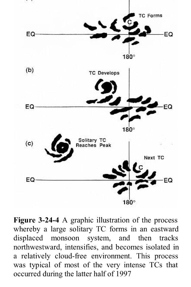
Many who track the Western Pacific tropics have been waiting to see what this October brings, myself included. Now, as we draw to within a week of the most prolific month of the year for super typhoons climatologically, things are looking ripe. Of particular note is a westerly wind burst just now starting to winds up and set to progress east of the International Dateline. This should promote an active monsoon trough near the dateline for storms to move west and develop from. Many of the strongest and longest lasting El Nino typhoons developed from similar setups, including several from 1997. In fact, this graphic from the 1997 JTWC Report illustrates the process quite well.

Image

If the dateline activity that most of the numerical models are picking up on comes to fruition, we could be looking at some ACE monsters.
0 likes   
Contract Meteorologist. TAMU & MSST. Fiercely authentic, one of a kind. We are all given free will, so choose a life meant to be lived. We are the Masters of our own Stories.
Opinions expressed are mine alone.

Follow me on Twitter at @1900hurricane : Read blogs at https://1900hurricane.wordpress.com/

euro6208

Re: 2015 WPAC Season

#527 Postby euro6208 » Fri Sep 25, 2015 9:29 pm

2015 is remarkably almost identical to 1997 but more active in the MT category.

Here is the stats as we head into October for both years.

1997:

24 TS
15 TY
8 MT
6 Cat 5

2015:

24 ts
15 ty
11 potential 12
5 Cat 5 potential 6

If Dujuan becomes a MT and a Cat 5, 2015 would be at 12 and 6.

I wonder if 2015 can keep on pace. This is how 1997 ended. :eek:

Image
Last edited by euro6208 on Thu Oct 01, 2015 9:37 am, edited 2 times in total.
0 likes   

User avatar
1900hurricane
Category 5
Category 5
Posts: 6059
Age: 34
Joined: Fri Feb 06, 2015 12:04 pm
Location: Houston, TX
Contact:

#528 Postby 1900hurricane » Sat Sep 26, 2015 12:05 pm

The first few days of October might still be quiet, but I'm thinking stuff will start to get going near the end of the first week for sure, which is near the ending timeframe of the graphic above. On next weeks update, I'd be very surprised if I didn't see some red hatching out near the dateline.
0 likes   
Contract Meteorologist. TAMU & MSST. Fiercely authentic, one of a kind. We are all given free will, so choose a life meant to be lived. We are the Masters of our own Stories.
Opinions expressed are mine alone.

Follow me on Twitter at @1900hurricane : Read blogs at https://1900hurricane.wordpress.com/

euro6208

Re: 2015 WPAC Season

#529 Postby euro6208 » Sun Sep 27, 2015 2:23 am

Looks like we have another threat down the road and this came out of nowhere. It's located southeast of Guam and EURO keeps this weak for the next 144 hours, makes landfall over Luzon, and strengthens it to Mujigae, Choi-wan, or Koppu in 168 hours.

It makes landfall over Hainan as a typhoon and literally stalls it over the Gulf of Tonkin...

Image
0 likes   

euro6208

Re: 2015 WPAC Season

#530 Postby euro6208 » Sun Sep 27, 2015 2:27 am

EURO no longer shows a Marianas system. It develops twins near the dateline, Mujigae, Choi-wan, or Koppu and strengthens both into typhoons. One of them moves toward the Marianas, the other moves into the CPAC.

Image
0 likes   

euro6208

Re: 2015 WPAC Season

#531 Postby euro6208 » Sun Sep 27, 2015 2:36 am

00Z GFS no longer showing the twin Cat 5's and dropped Choi-wan.

Here is Mujigae at peak recurving...

Image
0 likes   

User avatar
mrbagyo
Category 5
Category 5
Posts: 3725
Age: 33
Joined: Thu Apr 12, 2012 9:18 am
Location: 14.13N 120.98E
Contact:

Re: 2015 WPAC Season

#532 Postby mrbagyo » Sun Sep 27, 2015 4:49 am

Image

Image

The monsoon trough extends 170 E to as far as 165 W

Then there's a wave south east of Guam
0 likes   
The posts in this forum are NOT official forecast and should not be used as such. They are just the opinion of the poster and may or may not be backed by sound meteorological data. They are NOT endorsed by any professional institution or storm2k.org. For official information, please refer to RSMC, NHC and NWS products.

euro6208

Re: 2015 WPAC Season

#533 Postby euro6208 » Sun Sep 27, 2015 6:05 am

Last edited by euro6208 on Sun Sep 27, 2015 4:58 pm, edited 2 times in total.
0 likes   

User avatar
1900hurricane
Category 5
Category 5
Posts: 6059
Age: 34
Joined: Fri Feb 06, 2015 12:04 pm
Location: Houston, TX
Contact:

#534 Postby 1900hurricane » Sun Sep 27, 2015 10:45 am

I wouldn't put too much stock in modeled intensity this far out. How many model runs showed Dujuan getting as intense as it now is several days before it got named? The important thing is pretty much all numerical guidance is consistent in showing some sort of development.

That 00Z ECMWF run was weird. Two dateline tropical cyclones developing from the monsoon trough and then moving east/west away from each other? That'd be way cool to see, but I highly doubt we'll see something like that.
0 likes   
Contract Meteorologist. TAMU & MSST. Fiercely authentic, one of a kind. We are all given free will, so choose a life meant to be lived. We are the Masters of our own Stories.
Opinions expressed are mine alone.

Follow me on Twitter at @1900hurricane : Read blogs at https://1900hurricane.wordpress.com/

dexterlabio
Category 5
Category 5
Posts: 3468
Joined: Sat Oct 24, 2009 11:50 pm

Re: 2015 WPAC Season

#535 Postby dexterlabio » Sun Sep 27, 2015 10:57 am

Models have been not so reliable track-wise for the past few weeks. Maybe I am wrong but also I noticed the big guys (GFS, ECMWF, etc.) haven't been so good at sniffing out development either. They're either overdeveloping phantom storms (mostly Cat5's) or keeping a blind eye on a system that turned out to be a strong one later on.
0 likes   
Personal Forecast Disclaimer:
The posts in this forum are NOT official forecast and should not be used as such. They are just the opinion of the poster and may or may not be backed by sound meteorological data. They are NOT endorsed by any professional institution or storm2k.org. For official information, please refer to the NHC and NWS products.

User avatar
1900hurricane
Category 5
Category 5
Posts: 6059
Age: 34
Joined: Fri Feb 06, 2015 12:04 pm
Location: Houston, TX
Contact:

#536 Postby 1900hurricane » Sun Sep 27, 2015 2:18 pm

Posted by Abraham Levy on Twitter, that westerly wind burst will be coming on strong. Keep in mind this graphic is U wind magnitudes, not anomalies. Major, major signal for both WPac activity and a strengthening El Nino.

Image
0 likes   
Contract Meteorologist. TAMU & MSST. Fiercely authentic, one of a kind. We are all given free will, so choose a life meant to be lived. We are the Masters of our own Stories.
Opinions expressed are mine alone.

Follow me on Twitter at @1900hurricane : Read blogs at https://1900hurricane.wordpress.com/

euro6208

Re: 2015 WPAC Season

#537 Postby euro6208 » Sun Sep 27, 2015 4:47 pm

mrbagyo wrote:The monsoon trough extends 170 E to as far as 165 W

Then there's a wave south east of Guam


Actually it's bigger than that. It extends from 140E all the way to 155W.

Image

It already has several disturbances that models develop down the road.
Last edited by euro6208 on Sun Sep 27, 2015 5:00 pm, edited 1 time in total.
0 likes   

euro6208

Re: 2015 WPAC Season

#538 Postby euro6208 » Sun Sep 27, 2015 4:58 pm

euro6208 wrote:Looks like we have another threat down the road and this came out of nowhere. It's located southeast of Guam and EURO keeps this weak for the next 144 hours, makes landfall over Luzon, and strengthens it to Mujigae, Choi-wan, or Koppu in 168 hours.

It makes landfall over Hainan as a typhoon and literally stalls it over the Gulf of Tonkin...


12Z EURO still latching onto this feature located south of Guam. It keeps it weak all the way to Luzon and Hainan and at very long range, 240 hours, starts to develop this steadily in the Gulf of Tonkin.

Image
0 likes   

euro6208

Re:

#539 Postby euro6208 » Sun Sep 27, 2015 8:30 pm

1900hurricane wrote:Posted by Abraham Levy on Twitter, that westerly wind burst will be coming on strong. Keep in mind this graphic is U wind magnitudes, not anomalies. Major, major signal for both WPac activity and a strengthening El Nino.


Guaranteed this major WWB will spark continuous cyclone activity near the dateline. It's going to be interesting just how many develops and how strong these get.

Scary to think because the Marianas has a 300% chance of getting hit from a major typhoon during major ninos.

Paka, Dec 97 Guam
Pongsona, Dec 02 Guam
Soudelor Jul 15 Saipan
0 likes   

euro6208

Re: 2015 WPAC Season

#540 Postby euro6208 » Mon Sep 28, 2015 2:22 am

:uarrow: :uarrow:

INVEST 99W is up

Models sensing something down the road.
0 likes   


Return to “Talkin' Tropics”

Who is online

Users browsing this forum: jaguars_22, jconsor, KeysRedWine and 42 guests