
ATL: INVEST 99L - Discussion
Moderator: S2k Moderators

-
gatorcane

- S2K Supporter

- Posts: 23708
- Age: 48
- Joined: Sun Mar 13, 2005 3:54 pm
- Location: Boca Raton, FL
Re:
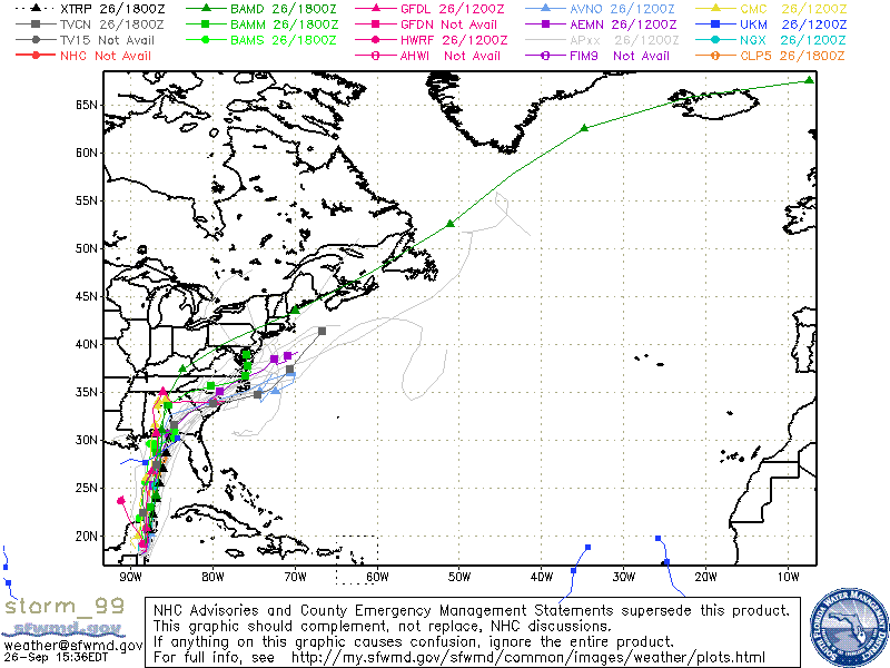
panamatropicwatch wrote:Pretty good consensus on model tracks.
http://tropicwatch.info/storm_99.gif
The new ECMWF run is a good deal east of those tracks with the low turning NE then ENE north of Tampa tracking over Cedar Key, FL.
Last edited by gatorcane on Sat Sep 26, 2015 3:10 pm, edited 1 time in total.
0 likes
-
Weatherwatcher98
- Category 1

- Posts: 346
- Joined: Sat Sep 12, 2015 10:53 am
Re: Invest 99L
Most if not all the weather is always east of a sheared system. Going to be wet for Florida Penisula in the coming days
0 likes
Personal Forecast Disclaimer:
The posts in this forum are NOT official forecast and should not be used as such. They are just the opinion of the poster and may or may not be backed by sound meteorological data. They are NOT endorsed by any professional institution or storm2k.org. For official information, please refer to the NHC and NWS products.
The posts in this forum are NOT official forecast and should not be used as such. They are just the opinion of the poster and may or may not be backed by sound meteorological data. They are NOT endorsed by any professional institution or storm2k.org. For official information, please refer to the NHC and NWS products.
-
gatorcane
- S2K Supporter
- Posts: 23708
- Age: 48
- Joined: Sun Mar 13, 2005 3:54 pm
- Location: Boca Raton, FL
Here is a good vis loop from the Navy NRL site:
http://www.nrlmry.navy.mil/nexsat-bin/n ... PE=Instant
http://www.nrlmry.navy.mil/nexsat-bin/n ... PE=Instant
Last edited by gatorcane on Sat Sep 26, 2015 3:16 pm, edited 1 time in total.
0 likes
-
Weatherwatcher98
- Category 1
- Posts: 346
- Joined: Sat Sep 12, 2015 10:53 am
Re:
Interesting. Maybe Euro is on to something and other the models will follow suitgatorcane wrote:Here is a good vis loop from the Navy:
http://www.nrlmry.navy.mil/nexsat-bin/n ... PE=Instant
0 likes
Personal Forecast Disclaimer:
The posts in this forum are NOT official forecast and should not be used as such. They are just the opinion of the poster and may or may not be backed by sound meteorological data. They are NOT endorsed by any professional institution or storm2k.org. For official information, please refer to the NHC and NWS products.
The posts in this forum are NOT official forecast and should not be used as such. They are just the opinion of the poster and may or may not be backed by sound meteorological data. They are NOT endorsed by any professional institution or storm2k.org. For official information, please refer to the NHC and NWS products.
-
Dean4Storms
- S2K Supporter
- Posts: 6358
- Age: 63
- Joined: Sun Aug 31, 2003 1:01 pm
- Location: Miramar Bch. FL
Re:
NDG wrote:18z SHIPS analyzes shear over it at 23 knots, it shows a steady increasing shear over it during the next 72 hrs, up to 53 knots by the time it approaches the northern gulf coat. So in another words, this is as organized as it will look over the next 72 hrs.
Yea, shear is already eating it alive!
0 likes
-
Weatherwatcher98
- Category 1
- Posts: 346
- Joined: Sat Sep 12, 2015 10:53 am
Re: Re:
Yeah but even sheared systems can dump copious amounts of rain. Western coast of Florida was hammered by remnants of Ericka and ripples of energy moving east before her. Flooding back in August is still in our minds in SW and Central Florida. Does not take an Organized Low to wreak havoc.Dean4Storms wrote:NDG wrote:18z SHIPS analyzes shear over it at 23 knots, it shows a steady increasing shear over it during the next 72 hrs, up to 53 knots by the time it approaches the northern gulf coat. So in another words, this is as organized as it will look over the next 72 hrs.
Yea, shear is already eating it alive!
0 likes
Personal Forecast Disclaimer:
The posts in this forum are NOT official forecast and should not be used as such. They are just the opinion of the poster and may or may not be backed by sound meteorological data. They are NOT endorsed by any professional institution or storm2k.org. For official information, please refer to the NHC and NWS products.
The posts in this forum are NOT official forecast and should not be used as such. They are just the opinion of the poster and may or may not be backed by sound meteorological data. They are NOT endorsed by any professional institution or storm2k.org. For official information, please refer to the NHC and NWS products.
-
Dean4Storms
- S2K Supporter
- Posts: 6358
- Age: 63
- Joined: Sun Aug 31, 2003 1:01 pm
- Location: Miramar Bch. FL
Re: Re:
Weatherwatcher98 wrote:Yeah but even sheared systems can dump copious amounts of rain. Western coast of Florida was hammered by remnants of Ericka and ripples of energy moving east before her. Flooding back in August is still in our minds in SW and Central Florida. Does not take an Organized Low to wreak havoc.Dean4Storms wrote:NDG wrote:18z SHIPS analyzes shear over it at 23 knots, it shows a steady increasing shear over it during the next 72 hrs, up to 53 knots by the time it approaches the northern gulf coat. So in another words, this is as organized as it will look over the next 72 hrs.
Yea, shear is already eating it alive!
I don't think either one of us are questioning that. We are pointing out the struggle to organize into a Tropical Cyclone with so much shear!
0 likes
-
Weatherwatcher98
- Category 1
- Posts: 346
- Joined: Sat Sep 12, 2015 10:53 am
Re: Invest 99L
I agree with that maybe a depression a weak Tropical/Sub tropical storm at best.
0 likes
Personal Forecast Disclaimer:
The posts in this forum are NOT official forecast and should not be used as such. They are just the opinion of the poster and may or may not be backed by sound meteorological data. They are NOT endorsed by any professional institution or storm2k.org. For official information, please refer to the NHC and NWS products.
The posts in this forum are NOT official forecast and should not be used as such. They are just the opinion of the poster and may or may not be backed by sound meteorological data. They are NOT endorsed by any professional institution or storm2k.org. For official information, please refer to the NHC and NWS products.
-
rolltide

- Tropical Storm

- Posts: 234
- Age: 65
- Joined: Thu Sep 09, 2004 5:33 pm
- Location: Pensacola Florida
Re: Invest 99L
On visible satellite it appears the low level coc is over the eastern Yucatan moving due north. Shear is blowing the cloud tops off to the eastern side of the coc.
0 likes
-
Frank P
- S2K Supporter
- Posts: 2779
- Joined: Fri Aug 29, 2003 10:52 am
- Location: Biloxi Beach, Ms
- Contact:
Re: Invest 99L
rolltide wrote:On visible satellite it appears the low level coc is over the eastern Yucatan moving due north. Shear is blowing the cloud tops off to the eastern side of the coc.
Yep, looks north to me too and boy it is getting a pounding from the shear.... my guess that it will eventually go north for a while then progress to a more NNE-NE motion after a day or two.. my untrained non-professional humble opinion only... still hope for some much needed rain out of this early next week on the MS coast... much needed
0 likes

Is it possible this ends up being a hybrid system like the early October systems of 1992/1994?
0 likes
The above post is not official and should not be used as such. It is the opinion of the poster and may or may not be backed by sound meteorological data. It is not endorsed by any professional institution or storm2k.org. For official information, please refer to the NHC and NWS products.
-
cycloneye

- Admin

- Posts: 149275
- Age: 69
- Joined: Thu Oct 10, 2002 10:54 am
- Location: San Juan, Puerto Rico
Re: ATL: INVEST 99L - Discussion
An area of low pressure located over the eastern Yucatan Peninsula
is producing disorganized showers and thunderstorms and gusty winds
over portions of the northwestern Caribbean Sea, the southeastern
Gulf of Mexico, and the Yucatan Peninsula. This system is expected
to move northward at about 10 mph into the southern Gulf of Mexico
on Sunday and should then move more quickly northward or
northeastward as it interacts with an upper-level low near the
Texas coast. While upper-level winds are only expected to be
marginally conducive, there is some potential for this system to
become a tropical cyclone during the next couple of days before it
reaches the northern Gulf Coast. Regardless of tropical cyclone
formation, this disturbance is likely to produce locally heavy
rainfall over portions of the northern Gulf Coast and southeastern
United States early next week. An Air Force Reserve reconnaissance
aircraft is scheduled to investigate this system tomorrow, if
necessary. For additional information on this system, see High Seas
Forecasts issued by the National Weather Service and products from
your local National Weather Service office.
* Formation chance through 48 hours...medium...40 percent
* Formation chance through 5 days...medium...40 percent
0 likes
Visit the Caribbean-Central America Weather Thread where you can find at first post web cams,radars
and observations from Caribbean basin members Click Here
and observations from Caribbean basin members Click Here

-
FlaStormFanatic
- Tropical Low

- Posts: 38
- Age: 43
- Joined: Sun Sep 06, 2015 7:51 pm
- Location: Kissimmee
Re:
panamatropicwatch wrote:Pretty good consensus on model tracks.
That's for sure.
0 likes
Erin 1995 Charley 2004 Frances 2004 Jeanne 2004.
Any posts made on this forum by me are strictly my opinion and may not be backed up by sound meteorological l data. They are also not endorsed by Storm2k. Please refer to the NHC or other weather offices products.
Any posts made on this forum by me are strictly my opinion and may not be backed up by sound meteorological l data. They are also not endorsed by Storm2k. Please refer to the NHC or other weather offices products.

Re: ATL: INVEST 99L - Discussion
My daughter is leaving on a cruise out of Tampa on Monday evening (9/28) headed for Grand Cayman. What type of weather conditions would be expected in the Gulf at that time based on the current forecast?
TIA.....Dave
TIA.....Dave
0 likes
Re: ATL: INVEST 99L - Discussion
CDO62 wrote:My daughter is leaving on a cruise out of Tampa on Monday evening (9/28) headed for Grand Cayman. What type of weather conditions would be expected in the Gulf at that time based on the current forecast?
TIA.....Dave
Some rough seas in the eastern GOM into the NW Caribbean with some heavy rains at time but nothing extreme.
0 likes
-
floridasun78
- Category 5

- Posts: 3755
- Joined: Sun May 17, 2009 10:16 pm
- Location: miami fl
-
rickybobby
- Tropical Storm
- Posts: 174
- Joined: Fri Sep 18, 2015 11:11 am
- Location: Central Florida
Re: ATL: INVEST 99L - Discussion
Wesh 2 said central Florida should be getting a lot of rain.
0 likes
Who is online
Users browsing this forum: No registered users and 109 guests