TROPICAL WEATHER OUTLOOK
NWS NATIONAL HURRICANE CENTER MIAMI FL
800 PM EDT FRI SEP 25 2015
<snip>
2. Disorganized showers and a few thunderstorms over the western
Atlantic Ocean several hundred miles south-southwest of Bermuda are
associated with an upper-level low and a surface trough.
Development, if any, of this system is expected to be slow to occur
while it drifts toward the north. Upper-level winds are forecast to
become unfavorable for development after the weekend.
* Formation chance through 48 hours...low...10 percent
* Formation chance through 5 days...low...10 percent
ATL: JOAQUIN - Post-Tropical - Discussion
Moderator: S2k Moderators
-
AJC3

- Admin

- Posts: 4156
- Age: 62
- Joined: Tue Aug 31, 2004 7:04 pm
- Location: Ballston Spa, New York
- Contact:
Re: Mid-Upper Low NE of Hispanola approx 24N 69W
Code: Select all
583
WHXX01 KWBC 260007
CHGHUR
TROPICAL CYCLONE GUIDANCE MESSAGE
NWS NATIONAL HURRICANE CENTER MIAMI FL
0007 UTC SAT SEP 26 2015

DISCLAIMER...NUMERICAL MODELS ARE SUBJECT TO LARGE ERRORS.
PLEASE REFER TO NHC OFFICIAL FORECASTS FOR TROPICAL CYCLONE
AND SUBTROPICAL CYCLONE INFORMATION.

ATLANTIC OBJECTIVE AIDS FOR

DISTURBANCE INVEST (AL982015) 20150926 0000 UTC

        ...00 HRS...   ...12 HRS...   ...24 HRS...   ...36 HRS...
        150926  0000   150926  1200   150927  0000   150927  1200

         LAT    LON     LAT    LON     LAT    LON     LAT    LON
BAMS    24.5N  68.5W   25.7N  68.9W   26.7N  69.3W   27.6N  70.1W
BAMD    24.5N  68.5W   25.0N  68.6W   25.4N  68.6W   25.6N  68.9W
BAMM    24.5N  68.5W   25.5N  68.7W   26.3N  68.9W   27.0N  69.4W
LBAR    24.5N  68.5W   25.5N  68.5W   26.3N  68.4W   26.8N  68.4W
SHIP        20KTS          24KTS          31KTS          38KTS
DSHP        20KTS          24KTS          31KTS          38KTS

        ...48 HRS...   ...72 HRS...   ...96 HRS...   ..120 HRS...
        150928  0000   150929  0000   150930  0000   151001  0000

         LAT    LON     LAT    LON     LAT    LON     LAT    LON
BAMS    28.6N  71.0W   31.4N  72.3W   34.2N  69.9W   35.9N  67.0W
BAMD    25.7N  69.5W   25.5N  71.5W   25.1N  75.1W   25.4N  79.2W
BAMM    27.8N  70.1W   29.7N  71.4W   31.9N  70.9W   34.0N  68.3W
LBAR    27.0N  68.6W   27.5N  69.7W   28.1N  72.0W   27.9N  74.7W
SHIP        44KTS          48KTS          48KTS          48KTS
DSHP        44KTS          48KTS          48KTS          48KTS

         ...INITIAL CONDITIONS...
LATCUR =  24.5N LONCUR =  68.5W DIRCUR =   0DEG SPDCUR =   5KT
LATM12 =  23.5N LONM12 =  68.5W DIRM12 = 360DEG SPDM12 =   5KT
LATM24 =  22.0N LONM24 =  68.5W
WNDCUR =   20KT RMAXWD =   70NM WNDM12 =   15KT
CENPRS = 1011MB OUTPRS = 1012MB OUTRAD =   90NM SDEPTH =   S
RD34NE =    0NM RD34SE =    0NM RD34SW =    0NM RD34NW =   0NM

$$
NNNN
0 likes
-
cycloneye

- Admin
- Posts: 149840
- Age: 69
- Joined: Thu Oct 10, 2002 10:54 am
- Location: San Juan, Puerto Rico
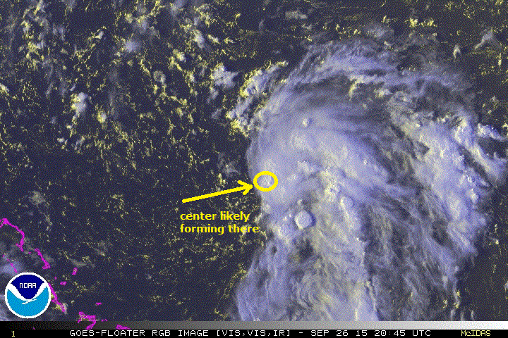
ATL: INVEST 98L - Discussion
Invest 98L
As of 00:00 UTC Sep 26, 2015:
Location: 24.5°N 68.5°W
Maximum Winds: 20 kt Gusts: N/A
Minimum Central Pressure: 1011 mb
Environmental Pressure: 1012 mb
Radius of Circulation: 90 NM
Radius of Maximum Wind: 70 NM
Thread at Talking Tropics that was the topic for this area.
viewtopic.php?f=31&t=117580&p=2479069#p2479069
0 likes
Visit the Caribbean-Central America Weather Thread where you can find at first post web cams,radars
and observations from Caribbean basin members Click Here
and observations from Caribbean basin members Click Here

-
floridasun78
- Category 5

- Posts: 3755
- Joined: Sun May 17, 2009 10:16 pm
- Location: miami fl
Re:
gatorcane wrote:NHC was pretty quick to make this invest. A bit surprised considering the lack of model support and no immediate threat to land.
Not sure if there is some other reason which made them pull the trigger so quickly.

0 likes
-
floridasun78
- Category 5
- Posts: 3755
- Joined: Sun May 17, 2009 10:16 pm
- Location: miami fl

Re:
gatorcane wrote:NHC was pretty quick to make this invest. A bit surprised considering the lack of model support and no immediate threat to land.
Not sure if there is some other reason which made them pull the trigger so quickly.
Gator,
Well, if you count the highly unreliable 0Z CMC, that has changed. It takes Invest 98L, develops it into a TC, turns it WNW underneath highs, develops it into a 994 mb strong TS shear be darned, and hits near Daytona bch/St. Aug. next Wed night/Thu 9/30-10/1:
http://www.tropicaltidbits.com/analysis ... 0&ypos=222
It looks a bit like the BAMD. Same timeframe but 200 miles north. But it is the CMC.
The 0Z GFS keeps it very weak and moves it NNW.
0 likes
Personal Forecast Disclaimer:
The posts in this forum are NOT official forecasts and should not be used as such. They are just the opinion of the poster and may or may not be backed by sound meteorological data. They are NOT endorsed by any professional institution or storm2k.org. For official information, please refer to the NHC and NWS products.
The posts in this forum are NOT official forecasts and should not be used as such. They are just the opinion of the poster and may or may not be backed by sound meteorological data. They are NOT endorsed by any professional institution or storm2k.org. For official information, please refer to the NHC and NWS products.
-
northjaxpro

- S2K Supporter

- Posts: 8900
- Joined: Mon Sep 27, 2010 11:21 am
- Location: Jacksonville, FL
Well interesting, my suspicions from a couple of days ago about the mid-upper Low trying to burrow down to the surface apparently is trying to manifest after all. Larry, I did see the CMC run and I would give it only a slim chance of coming to fruition of making landfall on the Northeast Florida coast. However, it will make a left turn for a short time and then will make the turn out to sea sometime within 72-94 hours. If this system manages to develop, it could get close to Bermuda in the next 3-4 days.
0 likes
NEVER, EVER SAY NEVER in the tropics and weather in general, and most importantly, with life itself!!
________________________________________________________________________________________
Fay 2008 Beryl 2012 Debby 2012 Colin 2016 Hermine 2016 Julia 2016 Matthew 2016 Irma 2017 Dorian 2019
________________________________________________________________________________________
Fay 2008 Beryl 2012 Debby 2012 Colin 2016 Hermine 2016 Julia 2016 Matthew 2016 Irma 2017 Dorian 2019
Re: ATL: INVEST 98L - Discussion
Jax,
Yep, good call. I just saw the GEPS. It has 5 members threaten FL next week with 2 being H's, 1 TS, 2 weaker lows. But, again, these 5 CMC members of 20 are pretty much on their own getting 98L that far west as opposed to recurving well E of there. It appears the reason for this is that the GEPS has very little sfc reflection in the NE GOM for 99L before this time allowing for different steering of 98L (further west) due to most of 99L runs being in NW GOM. I think the CMC/these CMC ens members are off. Why not since these are just perturbations of initial conditions for the Cartoon model. However, should 99L end up in the NW GOM instead of further E and if 98L were to form into a low on the southern end of the convection now out there, there'd be a slight chance for 98L to come close to FL intact though it would have shear to negotiate:
http://www.tropicaltidbits.com/analysis ... atl_21.png
0 likes
Personal Forecast Disclaimer:
The posts in this forum are NOT official forecasts and should not be used as such. They are just the opinion of the poster and may or may not be backed by sound meteorological data. They are NOT endorsed by any professional institution or storm2k.org. For official information, please refer to the NHC and NWS products.
The posts in this forum are NOT official forecasts and should not be used as such. They are just the opinion of the poster and may or may not be backed by sound meteorological data. They are NOT endorsed by any professional institution or storm2k.org. For official information, please refer to the NHC and NWS products.
The 12Z GFS has a weak low recurve well E of FL. However, the 12Z JMA 72 has a 1010ish low forming just NE of the Bahamas with 99L further NW in the GOM:
http://www.tropicaltidbits.com/analysis ... _atl_4.png
To compare, the 96 JMA from 24 hours ago had ~nothing for 98L:
http://www.tropicaltidbits.com/analysis ... _atl_5.png
Edit: 12Z CMC has 98L 150 miles NE of its 0Z CMC position at your 12. That, alone, tells me this run shoukd recurve well E of FL:
http://www.tropicaltidbits.com/analysis ... _atl_2.png
0 likes
Personal Forecast Disclaimer:
The posts in this forum are NOT official forecasts and should not be used as such. They are just the opinion of the poster and may or may not be backed by sound meteorological data. They are NOT endorsed by any professional institution or storm2k.org. For official information, please refer to the NHC and NWS products.
The posts in this forum are NOT official forecasts and should not be used as such. They are just the opinion of the poster and may or may not be backed by sound meteorological data. They are NOT endorsed by any professional institution or storm2k.org. For official information, please refer to the NHC and NWS products.
-
floridasun78
- Category 5
- Posts: 3755
- Joined: Sun May 17, 2009 10:16 pm
- Location: miami fl
2. Disorganized showers and thunderstorms over the western Atlantic
Ocean several hundred miles south-southwest of Bermuda are
associated with an upper-level low and a surface trough. Some
slow development of this system is possible during the next
day or two while it moves toward the north or north-northwest.
After that time, development is not expected due to unfavorable
upper-level winds.
* Formation chance through 48 hours...low...20 percent
* Formation chance through 5 days...low...20 percent
0 likes
-
ozonepete
- Professional-Met

- Posts: 4743
- Joined: Mon Sep 07, 2009 3:23 pm
- Location: From Ozone Park, NYC / Now in Brooklyn, NY
Re: ATL: INVEST 98L - Discussion
Between this and 99L, this has the best shot to be a TC first imho. Those waters are hot, and it has virtually no shear at all. Even the small amount of dry air to its west and north is diminishing as we speak. The rest of its circulation envelope is very moist. I think this will develop rapidly overnight and tomorrow. It's got "the look."

0 likes
-
YoshiMike
- Tropical Storm

- Posts: 106
- Age: 30
- Joined: Wed Aug 27, 2014 9:18 pm
- Location: Hattiesburg, MS
- Contact:
Re: ATL: INVEST 98L - Discussion
Watching closely juuuuust in case it decides to make a turn my way (in Connecticut now) doubt it will be never say never.
0 likes
Okay guys, just because I want to BE a meteorologist, want to go to school for meteorology, DOES NOT MAKE ME A METEOROLOGIST. Anything I say about tropical weather is either me learning something new, or is just an opinion and nothing more than that. I can almost guarantee you that I will be wrong about pretty much everything.
Re: ATL: INVEST 98L - Discussion
ozonepete wrote:Between this and 99L, this has the best shot to be a TC first imho. Those waters are hot, and it has virtually no shear at all. Even the small amount of dry air to its west and north is diminishing as we speak. The rest of its circulation envelope is very moist. I think this will develop rapidly overnight and tomorrow. It's got "the look."
1) Major kudos to jax for being the one to point out this area way before anyone else here!
2) No model/ens member (that I've seen) has anything close to rapid dev. So, IF this occurs, how should it affect the track? My feeling based on logic and model runs is the further east that is 99L in the GOM, the further E will be this at least below NC because he steering flow would be more N and less NW. The mods are hinting that it stays offshore the US but that it could get close to E NC NNE to E NE. But what if it were to intensify rapidly? Would that mean further offshore the US or something else?
Last edited by LarryWx on Sat Sep 26, 2015 5:13 pm, edited 1 time in total.
0 likes
Personal Forecast Disclaimer:
The posts in this forum are NOT official forecasts and should not be used as such. They are just the opinion of the poster and may or may not be backed by sound meteorological data. They are NOT endorsed by any professional institution or storm2k.org. For official information, please refer to the NHC and NWS products.
The posts in this forum are NOT official forecasts and should not be used as such. They are just the opinion of the poster and may or may not be backed by sound meteorological data. They are NOT endorsed by any professional institution or storm2k.org. For official information, please refer to the NHC and NWS products.
-
YoshiMike
- Tropical Storm
- Posts: 106
- Age: 30
- Joined: Wed Aug 27, 2014 9:18 pm
- Location: Hattiesburg, MS
- Contact:
^^ I would like to know the answer as well
0 likes
Okay guys, just because I want to BE a meteorologist, want to go to school for meteorology, DOES NOT MAKE ME A METEOROLOGIST. Anything I say about tropical weather is either me learning something new, or is just an opinion and nothing more than that. I can almost guarantee you that I will be wrong about pretty much everything.

Re: ATL: INVEST 98L - Discussion
I don't see this developing. Surface winds are very weak and it seems to be more of an east-west trough rather than any sort of closed low. The air to the west is steadily drying further as per WV imagery and there is no support from the models, which have tended to over-develop rather than under-develop storms this year.
0 likes
The above post is not official and should not be used as such. It is the opinion of the poster and may or may not be backed by sound meteorological data. It is not endorsed by any professional institution or storm2k.org. For official information, please refer to the NHC and NWS products.
-
cycloneye
- Admin
- Posts: 149840
- Age: 69
- Joined: Thu Oct 10, 2002 10:54 am
- Location: San Juan, Puerto Rico
Re: ATL: INVEST 98L - Discussion
Satellite imagery indicates that a weak area of surface low pressure
has formed about 450 miles south-southwest of Bermuda, and the
associated shower and thunderstorm activity has increased since
yesterday. Some additional gradual development of this system is
possible during the next couple of days while it moves toward the
north-northwest or northwest at 5 to 10 mph. After that time,
development is not expected due to unfavorable upper-level winds.
* Formation chance through 48 hours...medium...40 percent
* Formation chance through 5 days...medium...40 percent
0 likes
Visit the Caribbean-Central America Weather Thread where you can find at first post web cams,radars
and observations from Caribbean basin members Click Here
and observations from Caribbean basin members Click Here
-
AutoPenalti
- Category 5
- Posts: 4091
- Age: 29
- Joined: Mon Aug 17, 2015 4:16 pm
- Location: Ft. Lauderdale, Florida
Re: ATL: INVEST 98L - Discussion

CMC fantasy land in 5 days.
0 likes
The posts in this forum are NOT official forecasts and should not be used as such. They are just the opinion of the poster and may or may not be backed by sound meteorological data. They are NOT endorsed by any professional institution or STORM2K. For official information, please refer to products from the NHC and NWS.
Model Runs Cheat Sheet:
GFS (5:30 AM/PM, 11:30 AM/PM)
HWRF, GFDL, UKMET, NAVGEM (6:30-8:00 AM/PM, 12:30-2:00 AM/PM)
ECMWF (1:45 AM/PM)
TCVN is a weighted averaged
-
floridasun78
- Category 5
- Posts: 3755
- Joined: Sun May 17, 2009 10:16 pm
- Location: miami fl
Re: ATL: INVEST 98L - Discussion
that 98l by florida or IDA?AutoPenalti wrote:
CMC fantasy land in 5 days.
0 likes

Re: ATL: INVEST 98L - Discussion
This invest looks better for tropical development than 99L, at least in the short term.
0 likes
Who is online
Users browsing this forum: No registered users and 17 guests