ATL: JOAQUIN - Post-Tropical - Discussion
Moderator: S2k Moderators
Last edited by LarryWx on Sat Sep 26, 2015 9:50 pm, edited 1 time in total.
0 likes
Personal Forecast Disclaimer:
The posts in this forum are NOT official forecasts and should not be used as such. They are just the opinion of the poster and may or may not be backed by sound meteorological data. They are NOT endorsed by any professional institution or storm2k.org. For official information, please refer to the NHC and NWS products.
The posts in this forum are NOT official forecasts and should not be used as such. They are just the opinion of the poster and may or may not be backed by sound meteorological data. They are NOT endorsed by any professional institution or storm2k.org. For official information, please refer to the NHC and NWS products.
-
floridasun78
- Category 5

- Posts: 3755
- Joined: Sun May 17, 2009 10:16 pm
- Location: miami fl
Re:
LarryWx wrote::uarrow: That's 98L, not Ida, at 994 mb between Daytona and St. Augustine on the 126 hour map of the 0Z CMC. The 12Z CMC, which steers 98L north of he 0Z CMC track right from the start, has nothing like that and the 12Z CMC ensemble also didn't have those FL bound members. The 0Z CMC (along with several CMC ensemble members) look like they're out of touch with reality as they rely on an unrealistic (considering the progged features that would steer it) WNW all of the way to FL as well as surviving what is progged by the GFS runs strong shear several hundred miles E of FL.
so thing you may go ,more west their forecasting?
0 likes
There's always that chance but I believe that the chance of it getting all of the WNW to FL is quite small as of now. No other model than the 0Z CMC did that and the CMC is almost always wrong when it is on its own. And now the 12Z CMC dropped that scenario. If it were to form south of the model consensus, move WNW early, and if 99L doesn't bodily move to the NE GOM, then there'd be a better chance for that. However, even so, the progged sheer currently looks quite strong east of FL.
0 likes
Personal Forecast Disclaimer:
The posts in this forum are NOT official forecasts and should not be used as such. They are just the opinion of the poster and may or may not be backed by sound meteorological data. They are NOT endorsed by any professional institution or storm2k.org. For official information, please refer to the NHC and NWS products.
The posts in this forum are NOT official forecasts and should not be used as such. They are just the opinion of the poster and may or may not be backed by sound meteorological data. They are NOT endorsed by any professional institution or storm2k.org. For official information, please refer to the NHC and NWS products.
-
Hurricaneman

- Category 5
- Posts: 7404
- Age: 45
- Joined: Tue Aug 31, 2004 3:24 pm
- Location: central florida
Re:
LarryWx wrote::uarrow: floridasun,
There's always that chance but I believe that the chance of it getting all of the WNW to FL is quite small as of now. No other model than the 0Z CMC did that and the CMC is almost always wrong when it is on its own. And now the 12Z CMC dropped that scenario. If it were to form south of the model consensus, move WNW early, and if 99L doesn't bodily move to the NE GOM, then there'd be a better chance for that. However, even so, the progged sheer currently looks quite strong east of FL.
Honestly this may have a better chance of hitting Massachusetts than Florida based on model output but it needs to be watched in the NEUS and eastern Canada
The posts in this forum are NOT official forecast and should not be used as such. They are just the opinion of the poster and may or may not be backed by sound meteorological data. They are NOT endorsed by any professional institution or storm2k.org. For official information, please refer to the NHC and NWS products
0 likes
One thing I'm curious about is what would happen if it were to rapidly develop like OzonePete expects. No model has shown anything more than very slow development. Obviously, that could play havoc with the projected tracks and could make it somewhat more resistant to strong shear.
By the way, is that upper level outflow already getting established on the northside of this? Look at the last two hours or so of satellite pics.
0 likes
Personal Forecast Disclaimer:
The posts in this forum are NOT official forecasts and should not be used as such. They are just the opinion of the poster and may or may not be backed by sound meteorological data. They are NOT endorsed by any professional institution or storm2k.org. For official information, please refer to the NHC and NWS products.
The posts in this forum are NOT official forecasts and should not be used as such. They are just the opinion of the poster and may or may not be backed by sound meteorological data. They are NOT endorsed by any professional institution or storm2k.org. For official information, please refer to the NHC and NWS products.
-
Hurricaneman
- Category 5
- Posts: 7404
- Age: 45
- Joined: Tue Aug 31, 2004 3:24 pm
- Location: central florida
Re:
LarryWx wrote::uarrow: Hurricaneman, I agree that parts of the NE actually have a higher chance than the low FL chance to get hit by 98L.
One thing I'm curious about is what would happen if it were to rapidly develop like OzonePete expects. No model has shown anything more than very slow development. Obviously, that could play havoc with the projected tracks and could make it somewhat more resistant to strong shear.
By the way, is that upper level outflow already getting established on the northside of this? Look at the last two hours or so of satellite pics.
The funny thing is the 18zGFS has landfall in Rhode Island or SE Massachusetts and based on that 1985 Henri might be a good analog for this
The posts in this forum are NOT official forecast and should not be used as such. They are just the opinion of the poster and may or may not be backed by sound meteorological data. They are NOT endorsed by any professional institution or storm2k.org. For official information, please refer to the NHC and NWS products
0 likes
-
Extratropical94

- Professional-Met

- Posts: 3545
- Age: 31
- Joined: Wed Oct 20, 2010 6:36 am
- Location: Hamburg, Germany
- Contact:
Showers and thunderstorms associated with a low pressure area
located about 425 miles south-southwest of Bermuda have increased
over the past 24 hours. Some additional development of this system
is possible during the next day or so while it moves toward the
north-northwest or northwest at 5 to 10 mph. After that time,
development is not expected due to unfavorable upper-level winds.
For additional information on this system, see High Seas Forecasts
issued by the National Weather Service.
* Formation chance through 48 hours...medium...40 percent
* Formation chance through 5 days...medium...40 percent
0 likes
54° 11' 59'' N, 9° 9' 20'' E
Boomer Sooner!
Go Broncos! Go Cards!
Clinching counties, one at a time: https://mob-rule.com/user-gifs/USA/xtrp94.gif
- Daniel
Boomer Sooner!
Go Broncos! Go Cards!
Clinching counties, one at a time: https://mob-rule.com/user-gifs/USA/xtrp94.gif
- Daniel
-
Weatherwatcher98
- Category 1

- Posts: 346
- Joined: Sat Sep 12, 2015 10:53 am
Re: Re:
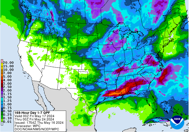
I agree and the wpc does too http://www.wpc.ncep.noaa.gov/qpf/p168i.gif?1443362630Hurricaneman wrote:LarryWx wrote::uarrow: floridasun,
There's always that chance but I believe that the chance of it getting all of the WNW to FL is quite small as of now. No other model than the 0Z CMC did that and the CMC is almost always wrong when it is on its own. And now the 12Z CMC dropped that scenario. If it were to form south of the model consensus, move WNW early, and if 99L doesn't bodily move to the NE GOM, then there'd be a better chance for that. However, even so, the progged sheer currently looks quite strong east of FL.
Honestly this may have a better chance of hitting Massachusetts than Florida based on model output but it needs to be watched in the NEUS and eastern Canada
The posts in this forum are NOT official forecast and should not be used as such. They are just the opinion of the poster and may or may not be backed by sound meteorological data. They are NOT endorsed by any professional institution or storm2k.org. For official information, please refer to the NHC and NWS products
0 likes
Personal Forecast Disclaimer:
The posts in this forum are NOT official forecast and should not be used as such. They are just the opinion of the poster and may or may not be backed by sound meteorological data. They are NOT endorsed by any professional institution or storm2k.org. For official information, please refer to the NHC and NWS products.
The posts in this forum are NOT official forecast and should not be used as such. They are just the opinion of the poster and may or may not be backed by sound meteorological data. They are NOT endorsed by any professional institution or storm2k.org. For official information, please refer to the NHC and NWS products.
-
YoshiMike
- Tropical Storm

- Posts: 106
- Age: 30
- Joined: Wed Aug 27, 2014 9:18 pm
- Location: Hattiesburg, MS
- Contact:
Re: ATL: INVEST 98L - Discussion
Up to 50/50
2. Showers and thunderstorms are showing signs of organization in
association with an area of low pressure located about 425 miles
south-southwest of Bermuda. Some additional development of this
system is possible and this system could become a tropical
depression during the next day or so while it moves toward
the northwest at 5 to 10 mph. After that time, development is not
expected due to unfavorable upper-level winds. For additional
information on this system, see High Seas Forecasts issued by the
National Weather Service.
* Formation chance through 48 hours...medium...50 percent
* Formation chance through 5 days...medium...50 percent
(from NHC)
EDIT!*****
ALSO looks like some convection firing up this AM by the top of the system. Idk if this matters because IDK where the center is expected to form, if it does at all, but thought I would post this anyway.
0 likes
Okay guys, just because I want to BE a meteorologist, want to go to school for meteorology, DOES NOT MAKE ME A METEOROLOGIST. Anything I say about tropical weather is either me learning something new, or is just an opinion and nothing more than that. I can almost guarantee you that I will be wrong about pretty much everything.
A LLC seems to be near 27N, 69W, moving slowly WNW. It should turn NNW by Tue or Wed. It looks like it may brush the NC Outer Banks after that though there may not be much to it then or it may combine with a piece of 99L's remnants. That's my current feeling about this anyway.
0 likes
Personal Forecast Disclaimer:
The posts in this forum are NOT official forecasts and should not be used as such. They are just the opinion of the poster and may or may not be backed by sound meteorological data. They are NOT endorsed by any professional institution or storm2k.org. For official information, please refer to the NHC and NWS products.
The posts in this forum are NOT official forecasts and should not be used as such. They are just the opinion of the poster and may or may not be backed by sound meteorological data. They are NOT endorsed by any professional institution or storm2k.org. For official information, please refer to the NHC and NWS products.
-
Extratropical94
- Professional-Met
- Posts: 3545
- Age: 31
- Joined: Wed Oct 20, 2010 6:36 am
- Location: Hamburg, Germany
- Contact:
2. Showers and thunderstorms have become better organized since
yesterday in association with an elongated area of low pressure
located about midway between the central Bahamas and Bermuda.
Additional slow development of this system is likely during the next
day or two while it moves toward the northwest at 5 to 10 mph. After
that time, development is not expected due to unfavorable
upper-level winds. For more information on this system, see High
Seas Forecasts issued by the National Weather Service.
* Formation chance through 48 hours...medium...60 percent
* Formation chance through 5 days...medium...60 percent
0 likes
54° 11' 59'' N, 9° 9' 20'' E
Boomer Sooner!
Go Broncos! Go Cards!
Clinching counties, one at a time: https://mob-rule.com/user-gifs/USA/xtrp94.gif
- Daniel
Boomer Sooner!
Go Broncos! Go Cards!
Clinching counties, one at a time: https://mob-rule.com/user-gifs/USA/xtrp94.gif
- Daniel
Looking at the 12Z CMC/JMA, 98L may look like it is coming for FL through the next three or so days with a slow but steady WNW movement. However, by Wed, the WNW steering flow is projected to end by these same models as high pressure to the NE causing that WNW steering moves eastward and the remnants of 99L come out to near the SE coast. With that setup, it would then almost for sure turn more NNW/N and may combine with 99L. The 12Z CMC actually has it hit the NE US 10/3-4 as a weak low moving NNW.
Hypothetically, had there been no 99L, the next high moving in may have moved in with a further south extent imparting a continued WNW flow/trapping 98L and allowing it to keep moving WNW all of the way to FL and hit there as a TC. This is actually what yesterday's 0Z CMC had shown:
http://www.tropicaltidbits.com/analysis ... 0&ypos=222
So, Floridians who don't want a TC hit maybe should thank 99L for existing.
Last edited by LarryWx on Sun Sep 27, 2015 1:27 pm, edited 1 time in total.
0 likes
Personal Forecast Disclaimer:
The posts in this forum are NOT official forecasts and should not be used as such. They are just the opinion of the poster and may or may not be backed by sound meteorological data. They are NOT endorsed by any professional institution or storm2k.org. For official information, please refer to the NHC and NWS products.
The posts in this forum are NOT official forecasts and should not be used as such. They are just the opinion of the poster and may or may not be backed by sound meteorological data. They are NOT endorsed by any professional institution or storm2k.org. For official information, please refer to the NHC and NWS products.
-
Weatherwatcher98
- Category 1
- Posts: 346
- Joined: Sat Sep 12, 2015 10:53 am
Re: ATL: INVEST 98L - Discussion
Good points but the CMC??? 
0 likes
Personal Forecast Disclaimer:
The posts in this forum are NOT official forecast and should not be used as such. They are just the opinion of the poster and may or may not be backed by sound meteorological data. They are NOT endorsed by any professional institution or storm2k.org. For official information, please refer to the NHC and NWS products.
The posts in this forum are NOT official forecast and should not be used as such. They are just the opinion of the poster and may or may not be backed by sound meteorological data. They are NOT endorsed by any professional institution or storm2k.org. For official information, please refer to the NHC and NWS products.
Re: ATL: INVEST 98L - Discussion
Weatherwatcher98 wrote:Good points but the CMC???
Hehe
0 likes
Personal Forecast Disclaimer:
The posts in this forum are NOT official forecasts and should not be used as such. They are just the opinion of the poster and may or may not be backed by sound meteorological data. They are NOT endorsed by any professional institution or storm2k.org. For official information, please refer to the NHC and NWS products.
The posts in this forum are NOT official forecasts and should not be used as such. They are just the opinion of the poster and may or may not be backed by sound meteorological data. They are NOT endorsed by any professional institution or storm2k.org. For official information, please refer to the NHC and NWS products.
-
Dean4Storms
- S2K Supporter

- Posts: 6358
- Age: 63
- Joined: Sun Aug 31, 2003 1:01 pm
- Location: Miramar Bch. FL
-
Weatherwatcher98
- Category 1
- Posts: 346
- Joined: Sat Sep 12, 2015 10:53 am
Re:
I think so.CrazyC83 wrote:Is this the same system several other models want to develop in the Northeast next weekend?
0 likes
Personal Forecast Disclaimer:
The posts in this forum are NOT official forecast and should not be used as such. They are just the opinion of the poster and may or may not be backed by sound meteorological data. They are NOT endorsed by any professional institution or storm2k.org. For official information, please refer to the NHC and NWS products.
The posts in this forum are NOT official forecast and should not be used as such. They are just the opinion of the poster and may or may not be backed by sound meteorological data. They are NOT endorsed by any professional institution or storm2k.org. For official information, please refer to the NHC and NWS products.
-
Yellow Evan

- Professional-Met
- Posts: 16231
- Age: 27
- Joined: Fri Jul 15, 2011 12:48 pm
- Location: Henderson, Nevada/Honolulu, HI
- Contact:
-
gatorcane

- S2K Supporter
- Posts: 23708
- Age: 48
- Joined: Sun Mar 13, 2005 3:54 pm
- Location: Boca Raton, FL
Yep it is looking like it may make a run at becoming our next named system. For once, there is not a lot of shear over a system in the Atlantic, a rare sight this year:

Last edited by gatorcane on Sun Sep 27, 2015 3:00 pm, edited 1 time in total.
0 likes
-
Yellow Evan
- Professional-Met
- Posts: 16231
- Age: 27
- Joined: Fri Jul 15, 2011 12:48 pm
- Location: Henderson, Nevada/Honolulu, HI
- Contact:
Re: ATL: INVEST 98L - Discussion
Code: Select all
                    * ATLANTIC     SHIPS INTENSITY FORECAST          *
                    * IR SAT DATA AVAILABLE,       OHC AVAILABLE     *
                    *  INVEST      AL982015  09/27/15  18 UTC        *

TIME (HR)          0     6    12    18    24    36    48    60    72    84    96   108   120
V (KT) NO LAND    25    28    31    34    37    40    43    44    48    48    44    36    23
V (KT) LAND       25    28    31    34    37    40    43    44    48    48    44    36    29
V (KT) LGE mod    25    27    29    31    33    35    37    40    44    49    51    46    33
Storm Type      TROP  TROP  TROP  TROP  TROP  TROP  TROP  TROP  TROP  TROP  TROP  EXTP  EXTP

SHEAR (KT)        14    16    23    21    18    25    15    14     8    31    59    91   106
SHEAR ADJ (KT)     0     2    -3    -3     0    -3    -1    -5     2     0     0   -20   -19
SHEAR DIR        328   323   334   345   342   348    15   343   226   231   219   222   217
SST (C)         29.7  29.8  29.7  29.7  29.7  29.5  29.1  28.7  28.3  28.0  26.8  25.0  24.1
POT. INT. (KT)   161   163   162   162   162   158   151   145   141   137   122   105    97
ADJ. POT. INT.   135   138   138   137   137   134   127   122   119   116   103    88    82
200 MB T (C)   -54.5 -54.2 -54.4 -54.5 -54.1 -53.9 -53.6 -53.4 -53.2 -53.1 -53.4 -54.3 -54.9
TH_E DEV (C)       8     8     8     8     8     8     8     7     6     1     0     0     0
700-500 MB RH     72    72    70    68    66    67    68    72    73    73    72    63    54
MODEL VTX (KT)     9     9     9     9     9     7     6     4  LOST  LOST  LOST  LOST  LOST
850 MB ENV VOR    49    62    55    51    51    35    23    42    83    72    96    61    48
200 MB DIV        -4    -9    -3   -18   -11   -15     7    41    67    52   100    56    72
700-850 TADV       0     1    -1    -3     1    -2     1     2     0     6    14    26    27
LAND (KM)        849   866   883   906   894   787   677   562   391   240   143    55   -42
LAT (DEG N)     27.3  27.5  27.7  28.0  28.2  28.6  29.3  30.1  31.7  33.7  35.9  37.9  39.2
LONG(DEG W)     69.0  69.5  70.0  70.6  71.1  72.3  73.4  74.2  74.5  74.2  74.3  74.7  75.7
STM SPEED (KT)     3     5     5     5     5     6     6     6     9    10    11     9     7
HEAT CONTENT      60    57    52    52    58    56    41    24    21    16    44     0     0

  FORECAST TRACK FROM BAMM      INITIAL HEADING/SPEED (DEG/KT):320/  2      CX,CY:   0/  2
  T-12 MAX WIND:  20            PRESSURE OF STEERING LEVEL (MB):  624  (MEAN=624)
  GOES IR BRIGHTNESS TEMP. STD DEV.  50-200 KM RAD:  24.8 (MEAN=14.5)
  % GOES IR PIXELS WITH T < -20 C    50-200 KM RAD:  46.0 (MEAN=65.0)

                        INDIVIDUAL CONTRIBUTIONS TO INTENSITY CHANGE
                         6   12   18   24   36   48   60   72   84   96  108  120
                        ----------------------------------------------------------
  SAMPLE MEAN CHANGE     1.   2.   3.   4.   6.   8.   9.  11.  12.  12.  13.  14.
  SST POTENTIAL          0.   0.   1.   2.   6.  11.  17.  22.  25.  27.  28.  28.
  VERTICAL SHEAR MAG     1.   3.   5.   6.   7.   6.   4.   3.   0.  -6. -16. -30.
  VERTICAL SHEAR ADJ     0.   0.   0.   0.   1.   1.   2.   2.   2.   2.   3.   3.
  VERTICAL SHEAR DIR     0.   0.   0.   0.   0.   0.   0.   0.   2.   4.   5.   7.
  PERSISTENCE            1.   1.   2.   2.   2.   2.   2.   1.   1.   1.   0.   0.
  200/250 MB TEMP.       0.   0.   1.   1.   1.   2.   2.   2.   2.   3.   4.   5.
  THETA_E EXCESS         0.   0.  -1.  -1.  -2.  -2.  -3.  -5.  -8. -11. -14. -17.
  700-500 MB RH          0.   0.   0.  -1.  -1.  -2.  -3.  -3.  -3.  -3.  -3.  -2.
  MODEL VTX TENDENCY     0.   0.   0.   0.  -2.  -4.  -7.  -7.  -7.  -7.  -7.  -7.
  850 MB ENV VORTICITY   0.   0.   1.   1.   1.   1.   1.   2.   2.   3.   4.   4.
  200 MB DIVERGENCE      0.   0.  -1.  -1.  -2.  -2.  -2.  -2.  -1.   0.   0.   0.
  850-700 T ADVEC        0.   0.   0.   0.   0.   0.   0.   0.   0.   0.   0.  -1.
  ZONAL STORM MOTION     0.   0.   0.   0.   0.  -1.  -1.  -1.  -2.  -2.  -3.  -3.
  STEERING LEVEL PRES    0.   0.   0.   0.   0.   0.   0.   0.   0.   0.   0.   0.
  DAYS FROM CLIM. PEAK   0.   0.   0.   0.   0.   0.   0.   0.   0.   0.   0.   0.
  GOES PREDICTORS        0.  -1.  -1.  -1.  -2.  -2.  -3.  -3.  -3.  -3.  -2.  -2.
  OCEAN HEAT CONTENT     0.   0.   0.   0.   0.   0.   0.   0.   0.   0.   0.   0.
                        ----------------------------------------------------------
  TOTAL CHANGE           3.   6.   9.  12.  15.  18.  19.  23.  23.  19.  11.  -2.

   ** 2013 ATLANTIC RI INDEX AL982015 INVEST     09/27/15  18 UTC **
           ( 30 KT OR MORE MAX WIND INCREASE IN NEXT 24 HR)

 12 HR PERSISTENCE (KT):   5.0 Range:-49.5 to  33.0 Scaled/Wgted Val:  0.7/  1.9
 850-200 MB SHEAR (KT) :  18.3 Range: 28.8 to   2.9 Scaled/Wgted Val:  0.4/  0.5
 STD DEV OF IR BR TEMP :  24.8 Range: 37.5 to   2.9 Scaled/Wgted Val:  0.4/  0.5
 850-700 MB REL HUM (%):  72.4 Range: 43.2 to  93.5 Scaled/Wgted Val:  0.6/  0.7
 POT = MPI-VMAX (KT)   : 111.9 Range: 28.4 to 139.1 Scaled/Wgted Val:  0.8/  0.5
 Heat content (KJ/cm2) :  55.8 Range:  0.0 to 155.1 Scaled/Wgted Val:  0.4/  0.1
 D200 (10**7s-1)       :  -9.0 Range:-23.1 to 181.5 Scaled/Wgted Val:  0.1/  0.0
 % area w/pixels <-30 C:  42.0 Range: 15.3 to 100.0 Scaled/Wgted Val:  0.3/  0.1

 Prob of RI for 25 kt RI threshold=    17% is   1.5 times the sample mean(11.9%)
 Prob of RI for 30 kt RI threshold=    10% is   1.3 times the sample mean( 7.6%)
 Prob of RI for 35 kt RI threshold=     5% is   1.2 times the sample mean( 4.6%)
 Prob of RI for 40 kt RI threshold=     4% is   1.4 times the sample mean( 3.0%)

   ##         ANNULAR HURRICANE INDEX (AHI) AL982015 INVEST     09/27/15  18 UTC         ##
   ## STORM NOT ANNULAR, SCREENING STEP FAILED, NPASS=1 NFAIL=6                          ##
   ## AHI=  0   (AHI OF 100 IS BEST FIT TO ANN. STRUC., 1 IS MARGINAL, 0 IS NOT ANNULAR) ##

** PROBLTY OF AT LEAST 1 SCNDRY EYEWL FORMTN EVENT AL982015 INVEST     09/27/2015  18 UTC **
TIME(HR)   0-12  12-24(0-24)  24-36(0-36)  36-48(0-48)
CLIMO(%)     0      0(  0)       0(  0)       0(  0)     <-- PROB BASED ON INTENSITY ONLY
PROB(%)      0      0(  0)       0(  0)       0(  0)     <-- FULL MODEL PROB (RAN NORMALLY)
0 likes
Who is online
Users browsing this forum: No registered users and 44 guests