WPAC: DUJUAN - Post-Tropical
Moderator: S2k Moderators

Re: WPAC: DUJUAN - Typhoon
In Taichung City, just got power back after a 1 hr outage. Minimal rain, but strong gusts of wind. Not a lot of damage visible, but this is just the beginning.
0 likes
-
euro6208
Re: WPAC: DUJUAN - Typhoon
First Chan-hom, Noul, Soudelor, Goni, and now Dujuan making an impact in this unlucky part of the basin as Cat 3+. Too bad we have 3 months more to go. 
0 likes
-
euro6208
Re:
NotoSans wrote:The Yonaguni Island just recorded ten-minute sustained winds of 51.6 m/s (100.3 kt), breaking the record set by Mary in 1965 (47.8 m/s)
UPDATE:
The weather station also recorded gust of 71.6 m/s (139.2 kt), breaking the record set by Doug in 1994 (70.2 m/s).
Meanwhile, JMA kept the intensity at 100 kt at 06Z.
WOw...awful night for them coming.
Considering how far they are from the eyewall for winds this strong, I think we are dealing with a Cat 5.
Last edited by euro6208 on Mon Sep 28, 2015 2:16 am, edited 1 time in total.
0 likes
-
Extratropical94

- Professional-Met

- Posts: 3545
- Age: 31
- Joined: Wed Oct 20, 2010 6:36 am
- Location: Hamburg, Germany
- Contact:
Dujuan is a good candidate for a post-season-reanalysis upgrade to a STY.
0 likes
54° 11' 59'' N, 9° 9' 20'' E
Boomer Sooner!
Go Broncos! Go Cards!
Clinching counties, one at a time: https://mob-rule.com/user-gifs/USA/xtrp94.gif
- Daniel
Boomer Sooner!
Go Broncos! Go Cards!
Clinching counties, one at a time: https://mob-rule.com/user-gifs/USA/xtrp94.gif
- Daniel
-
euro6208
Re: WPAC: DUJUAN - Typhoon
Pressure in the westernmost island in the southern Ryukyu's Yonaguni is 960 mb.
0 likes

-
euro6208
Re: WPAC: DUJUAN - Typhoon
It's gonna be a long night for Taiwan. Western eyewall coming ashore.

0 likes
-
euro6208
Re: WPAC: DUJUAN - Typhoon
It's crushing all right.
The mountains of Yilan county in NE Taiwan already inundated with 317 mm (12.48 in) and it's far from over.
The mountains of Yilan county in NE Taiwan already inundated with 317 mm (12.48 in) and it's far from over.
0 likes
JMA has bumped the intensity to 110 kt based on surface observations, making Dujuan a violent typhoon.
Maximum 10-minute sustained winds and gust recorded were 54.6 m/s (106.1 kt) and 81.1 m/s (157.7 kt), respectively.
TY 1521 (DUJUAN)
Issued at 07:40 UTC, 28 September 2015
<Analyses at 28/07 UTC>
Scale -
Intensity Violent
Center position N24°10'(24.2°)
E122°35'(122.6°)
Direction and speed of movement NW 25km/h(13kt)
Central pressure 925hPa
Maximum wind speed near the center 55m/s(110kt)
Maximum wind gust speed 80m/s(160kt)
Area of 50kt winds or more ALL150km(80NM)
Area of 30kt winds or more W440km(240NM)
E390km(210NM)
0 likes
-
1900hurricane

- Category 5

- Posts: 6063
- Age: 34
- Joined: Fri Feb 06, 2015 12:04 pm
- Location: Houston, TX
- Contact:
Yonagunijima had a gust to 158 kt (81.1 m/s)? Are you kidding me?!
*EDIT for correct units.
*EDIT for correct units.
Last edited by 1900hurricane on Mon Sep 28, 2015 3:57 am, edited 1 time in total.
0 likes
Contract Meteorologist. TAMU & MSST. Fiercely authentic, one of a kind. We are all given free will, so choose a life meant to be lived. We are the Masters of our own Stories.
Opinions expressed are mine alone.
Follow me on Twitter at @1900hurricane : Read blogs at https://1900hurricane.wordpress.com/
Opinions expressed are mine alone.
Follow me on Twitter at @1900hurricane : Read blogs at https://1900hurricane.wordpress.com/


-
1900hurricane
- Category 5
- Posts: 6063
- Age: 34
- Joined: Fri Feb 06, 2015 12:04 pm
- Location: Houston, TX
- Contact:
Josh of iCyclone sounds like he's seeing some gnarly things based on his last Twitter post.
0 likes
Contract Meteorologist. TAMU & MSST. Fiercely authentic, one of a kind. We are all given free will, so choose a life meant to be lived. We are the Masters of our own Stories.
Opinions expressed are mine alone.
Follow me on Twitter at @1900hurricane : Read blogs at https://1900hurricane.wordpress.com/
Opinions expressed are mine alone.
Follow me on Twitter at @1900hurricane : Read blogs at https://1900hurricane.wordpress.com/
-
mrbagyo

- Category 5
- Posts: 3963
- Age: 33
- Joined: Thu Apr 12, 2012 9:18 am
- Location: 14.13N 120.98E
- Contact:
Re: WPAC: DUJUAN - Typhoon
1900hurricane wrote:Yonagunijima had a gust to 158 kt (81.1 kt)? Are you kidding me?!
won't surprise me if that was caused by an eyewall mesovortex,
Saw some on visible loops yesterday and today. Insane.
0 likes
The posts in this forum are NOT official forecast and should not be used as such. They are just the opinion of the poster and may or may not be backed by sound meteorological data. They are NOT endorsed by any professional institution or storm2k.org. For official information, please refer to RSMC, NHC and NWS products.
-
1900hurricane
- Category 5
- Posts: 6063
- Age: 34
- Joined: Fri Feb 06, 2015 12:04 pm
- Location: Houston, TX
- Contact:
Re: WPAC: DUJUAN - Typhoon
mrbagyo wrote:1900hurricane wrote:Yonagunijima had a gust to 158 kt (81.1 kt)? Are you kidding me?!
won't surprise me if that was caused by an eyewall mesovortex,
Saw some on visible loops yesterday and today. Insane.
Very possible. Here are some images from around the time of the gust.


0 likes
Contract Meteorologist. TAMU & MSST. Fiercely authentic, one of a kind. We are all given free will, so choose a life meant to be lived. We are the Masters of our own Stories.
Opinions expressed are mine alone.
Follow me on Twitter at @1900hurricane : Read blogs at https://1900hurricane.wordpress.com/
Opinions expressed are mine alone.
Follow me on Twitter at @1900hurricane : Read blogs at https://1900hurricane.wordpress.com/
-
1900hurricane
- Category 5
- Posts: 6063
- Age: 34
- Joined: Fri Feb 06, 2015 12:04 pm
- Location: Houston, TX
- Contact:
Both Josh and James reporting much calmer conditions after brutal winds in Suao, Taiwan. They might be entering the edge of the eye.
0 likes
Contract Meteorologist. TAMU & MSST. Fiercely authentic, one of a kind. We are all given free will, so choose a life meant to be lived. We are the Masters of our own Stories.
Opinions expressed are mine alone.
Follow me on Twitter at @1900hurricane : Read blogs at https://1900hurricane.wordpress.com/
Opinions expressed are mine alone.
Follow me on Twitter at @1900hurricane : Read blogs at https://1900hurricane.wordpress.com/
-
jaguarjace

- Category 4

- Posts: 975
- Age: 31
- Joined: Sat Jun 11, 2011 7:38 am
- Location: Khon Kaen, Thailand
Re: WPAC: DUJUAN - Typhoon

0 likes
Owner of the Tropical Archive YouTube channel
Web Developer at Force Thirteen
Twitter/X : @force13_support
Web Developer at Force Thirteen
Twitter/X : @force13_support
-
1900hurricane
- Category 5
- Posts: 6063
- Age: 34
- Joined: Fri Feb 06, 2015 12:04 pm
- Location: Houston, TX
- Contact:
Frictional convergence doing its thing as Dujuan begins to push ashore.

0 likes
Contract Meteorologist. TAMU & MSST. Fiercely authentic, one of a kind. We are all given free will, so choose a life meant to be lived. We are the Masters of our own Stories.
Opinions expressed are mine alone.
Follow me on Twitter at @1900hurricane : Read blogs at https://1900hurricane.wordpress.com/
Opinions expressed are mine alone.
Follow me on Twitter at @1900hurricane : Read blogs at https://1900hurricane.wordpress.com/
-
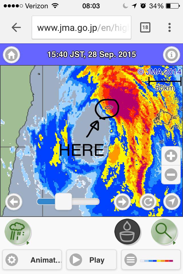
euro6208
Re: WPAC: DUJUAN - Typhoon
Looks like landfall will be over this rail train city, can't find the name and location and second picture is of Suao where our stormchasers are at this moment.


WDPN31 PGTW 280900
MSGID/GENADMIN/JOINT TYPHOON WRNCEN PEARL HARBOR HI//
SUBJ/PROGNOSTIC REASONING FOR TYPHOON 21W (DUJUAN) WARNING NR 27//
RMKS/
1. FOR METEOROLOGISTS.
2. 6 HOUR SUMMARY AND ANALYSIS.
TYPHOON (TY) 21W (DUJUAN), LOCATED APPROXIMATELY 101 NM SOUTHEAST
OF TAIPEI, TAIWAN, HAS TRACKED NORTHWESTWARD AT 10 KNOTS OVER THE
PAST SIX HOURS. ANIMATED MULTISPECTRAL SATELLITE IMAGERY (MSI) SHOWS
THE SYSTEM HAS MAINTAINED A SHARPLY-OUTLINED 28-NM EYE EVEN AS THE
DEEP CONVECTIVE BANDING HAS BEGUN TO LOOSEN WITH UNRAVELING ALONG THE
WESTERN SIDE THAT IS BEGINNING TO INTERACT WITH NORTHERN TAIWAN. THE
INITIAL POSITION IS BASED ON THE EYE FEATURE IN THE MSI LOOP WITH
HIGH CONFIDENCE. THE INITIAL INTENSITY OF 120 KNOTS IS BASED ON AN
OVERALL ASSESSMENT OF DVORAK ESTIMATES FROM ALL REPORTING AGENCIES
AND REFLECTS THE SLIGHT WEAKENING. UPPER LEVEL ANALYSIS INDICATES THE
SYSTEM REMAINS IN A LOW (05-10 KNOT) VERTICAL WIND SHEAR AREA WITH
GOOD RADIAL OUTFLOW. THE CYCLONE IS CURRENTLY TRACKING ALONG THE
SOUTHERN PERIPHERY OF AN EXTENSION OF THE SUBTROPICAL RIDGE TO THE EAST.
3. FORECAST REASONING.
A. NO SIGNIFICANT CHANGE IN THE FORECAST PHILOSOPHY SINCE THE
PREVIOUS PROGNOSTIC REASONING MESSAGE.
B. TY DUJUAN WILL MAINTAIN A WEST-NORTHWESTWARD TRAJECTORY UP TO
TAU 36 BEFORE DEFLECTING NORTHWARD IN RESPONSE TO AN APPROACHING
MID-LATITUDE TROUGH OVER EASTERN CHINA. MAINLY DUE TO LAND
INTERACTION WITH TAIWAN AND CHINA, AND COOLING SEA SURFACE
TEMPERATURES IN THE TAIWAN STRAIT, THE SYSTEM WILL NOW WEAKEN -
GRADUALLY OVER THE NEXT SIX HOURS, THEN RAPIDLY AFTER LANDFALL INTO
TAIWAN. BY TAU 48, TY 21W WILL BE REDUCED TO A DISTURBANCE BELOW
WARNING CRITERIA. DYNAMIC MODEL GUIDANCE IS IN GOOD AGREEMENT
THROUGHOUT THE FORECAST PERIOD LENDING HIGH CONFIDENCE TO THE JTWC
FORECAST WHICH IS IN LINE WITH MULTI-MODEL CONSENSUS.//
NNNN
0 likes
-
euro6208
Re: WPAC: DUJUAN - Typhoon
spiral wrote:euro6208 wrote:It's crushing all right.
The mountains of Yilan county in NE Taiwan already inundated with 317 mm (12.48 in) and it's far from over.
I was referring to the core interacting with the mountains there is no need for your sarcasm
Where did this come from? You think every post is referring to yours?
0 likes
According to CWB, Dujuan has made landfall near Nan'ao, Yilan at 0940Z.
UPDATE: Su'ao recorded gust of 68.4 m/s (133.0 kt) at 1000Z.
UPDATE: Su'ao recorded gust of 68.4 m/s (133.0 kt) at 1000Z.
Last edited by NotoSans on Mon Sep 28, 2015 5:25 am, edited 1 time in total.
0 likes
Who is online
Users browsing this forum: No registered users and 45 guests