While everyone's paying attention to Joaquin, 99L appears to be tightening up on radar as some strong curved bands have developed over the eastern Gulf and a decent circulation about 100 miles west of Tampa is taking shape.
http://weather.rap.ucar.edu/radar/displ ... duration=4
ATL: INVEST 99L - Discussion
Moderator: S2k Moderators
- HurricaneBelle
- S2K Supporter

- Posts: 1209
- Joined: Sun Aug 27, 2006 6:12 pm
- Location: Clearwater, FL
- northjaxpro
- S2K Supporter

- Posts: 8900
- Joined: Mon Sep 27, 2010 11:21 am
- Location: Jacksonville, FL
If you also go to NWS long range radar as well, you can see and pick out a circulation as you mentioned about 100 miles due west of Clearwater. It will move inland by tomorrow afternoon somewhere in the Apalachee Bay region. As someone mentioned earlier, this will be the fourth system to impact that region of the GOM this season.
Last edited by northjaxpro on Mon Sep 28, 2015 11:08 pm, edited 1 time in total.
0 likes
NEVER, EVER SAY NEVER in the tropics and weather in general, and most importantly, with life itself!!
________________________________________________________________________________________
Fay 2008 Beryl 2012 Debby 2012 Colin 2016 Hermine 2016 Julia 2016 Matthew 2016 Irma 2017 Dorian 2019
________________________________________________________________________________________
Fay 2008 Beryl 2012 Debby 2012 Colin 2016 Hermine 2016 Julia 2016 Matthew 2016 Irma 2017 Dorian 2019
- northjaxpro
- S2K Supporter

- Posts: 8900
- Joined: Mon Sep 27, 2010 11:21 am
- Location: Jacksonville, FL
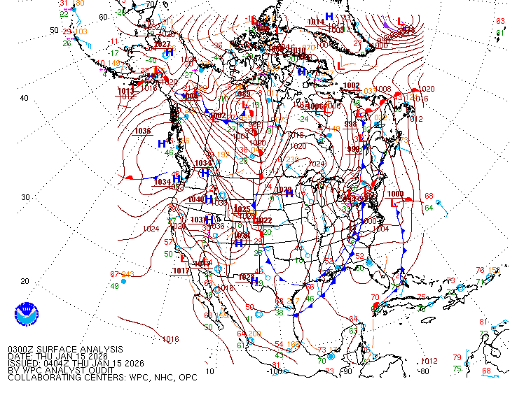
Interesting evening in the GOM with 2 Low Pressure systems. NHC/WPC surface analysis with the stationary 1005 mb Low just off the Upper TX coast and the 1006 mb Low just west of the Florida Gulf coast moving north-northeast.


0 likes
NEVER, EVER SAY NEVER in the tropics and weather in general, and most importantly, with life itself!!
________________________________________________________________________________________
Fay 2008 Beryl 2012 Debby 2012 Colin 2016 Hermine 2016 Julia 2016 Matthew 2016 Irma 2017 Dorian 2019
________________________________________________________________________________________
Fay 2008 Beryl 2012 Debby 2012 Colin 2016 Hermine 2016 Julia 2016 Matthew 2016 Irma 2017 Dorian 2019
- northjaxpro
- S2K Supporter

- Posts: 8900
- Joined: Mon Sep 27, 2010 11:21 am
- Location: Jacksonville, FL
If I am not mistaken, Air Force Reconnaisance aircraft is on its way to investigate 99L and is scheduled to arrive into it very shortly.
EDIT: It appears NHC cancelled that mission late today.
EDIT: It appears NHC cancelled that mission late today.
0 likes
NEVER, EVER SAY NEVER in the tropics and weather in general, and most importantly, with life itself!!
________________________________________________________________________________________
Fay 2008 Beryl 2012 Debby 2012 Colin 2016 Hermine 2016 Julia 2016 Matthew 2016 Irma 2017 Dorian 2019
________________________________________________________________________________________
Fay 2008 Beryl 2012 Debby 2012 Colin 2016 Hermine 2016 Julia 2016 Matthew 2016 Irma 2017 Dorian 2019
Re: ATL: INVEST 99L - Discussion
HurricaneBelle wrote:NDG wrote:I got more rain (western Seminole County) today than the Tampa Bay area which is in a flood watch. Received 2" in less than an hr, it was intense.
That radar product can't be completely accurate. It shows a trace throughout Pinellas County where it's been raining almost non-stop (outside of an hour break or so) since about 1:30 PM, and that band that went through Orlando originally came through Clearwater around 2:45, while I was driving and the rainfall was so intense I could hardly see at one point. What's funny is that band petered out as it reached Pasco, then re-intensified late this afternoon near the Hernando-Citrus border as it arced ESE-SE into inland central FL.
thats exactly what happened. totally skipped us here in southern hernando county. I did hear distant thunder though. that line got real strong north of us. hearing thunder right now too.
0 likes
Robbielyn McCrary
I know just about enough to sound like I know what I'm talking about sometimes. But for your safety please follow the nhc for truly professional forecasting.
I know just about enough to sound like I know what I'm talking about sometimes. But for your safety please follow the nhc for truly professional forecasting.
Re: ATL: INVEST 99L - Discussion
Right turn over Florida. Giving me a good downpour as I type.
A small outlflow burst on visible.
A small outlflow burst on visible.
0 likes
-
SeGaBob
- tropicwatch
- Category 5

- Posts: 3426
- Age: 62
- Joined: Sat Jun 02, 2007 10:01 am
- Location: Panama City Florida
- Contact:
Look at naked little ol' 99L.
http://weather.msfc.nasa.gov/cgi-bin/get-goes?satellite=GOES-E%20CONUS&lat=31&lon=-80&type=Animation&info=vis&numframes=15
http://weather.msfc.nasa.gov/cgi-bin/get-goes?satellite=GOES-E%20CONUS&lat=31&lon=-80&type=Animation&info=vis&numframes=15
0 likes
Tropicwatch
Agnes 72', Eloise 75, Elena 85', Kate 85', Charley 86', Florence 88', Beryl 94', Dean 95', Erin 95', Opal 95', Earl 98', Georges 98', Ivan 2004', Arlene 2005', Dennis 2005', Ida 2009' Debby 2012' Irma 2017' Michael 2018'
Agnes 72', Eloise 75, Elena 85', Kate 85', Charley 86', Florence 88', Beryl 94', Dean 95', Erin 95', Opal 95', Earl 98', Georges 98', Ivan 2004', Arlene 2005', Dennis 2005', Ida 2009' Debby 2012' Irma 2017' Michael 2018'
- AJC3
- Admin

- Posts: 4153
- Age: 62
- Joined: Tue Aug 31, 2004 7:04 pm
- Location: Ballston Spa, New York
- Contact:
Re: ATL: INVEST 99L - Discussion
For giggles...
The remnant 99L vortex is actually dropping southward through our local marine area. It's now located about 50 miles ESE of Cape Canaveral and can be seen pretty easily on our radar imagery. We tracked it as it moved east across north Florida , where it emerged east of JAX on TUE night, where it turned and started dropping southward since WED morning.
The remnant 99L vortex is actually dropping southward through our local marine area. It's now located about 50 miles ESE of Cape Canaveral and can be seen pretty easily on our radar imagery. We tracked it as it moved east across north Florida , where it emerged east of JAX on TUE night, where it turned and started dropping southward since WED morning.
0 likes
Who is online
Users browsing this forum: No registered users and 119 guests


