ATL: JOAQUIN - Post-Tropical - Discussion
Moderator: S2k Moderators
-
TimeZone
-
seussianagenda
- Tropical Low

- Posts: 33
- Joined: Fri Sep 05, 2008 4:54 pm

Re: ATL: JOAQUIN - Tropical Storm - Discussion
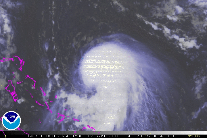
Is it me or is it starting to pick up some more speed in the last frames. Also looks like the eye like feature.

0 likes
The following post is NOT an official forecast and should not be used as such. It is just the opinion of the poster and may or may not be backed by sound meteorological data. It is NOT endorsed by any professional institution including storm2k.org For Official Information please refer to the NHC and NWS products.
-
Aric Dunn
- Category 5

- Posts: 21238
- Age: 43
- Joined: Sun Sep 19, 2004 9:58 pm
- Location: Ready for the Chase.
- Contact:
Re: ATL: JOAQUIN - Tropical Storm - Discussion
blp wrote:Is it me or is it starting to pick up some more speed in the last frames. Also looks like the eye like feature.
http://i57.tinypic.com/b3o395.gif
well its moving W to wsw .. but dont be fooled by the quickly expanding convection to the west.
0 likes
Note: If I make a post that is brief. Please refer back to previous posts for the analysis or reasoning. I do not re-write/qoute what my initial post said each time.
If there is nothing before... then just ask
Space & Atmospheric Physicist, Embry-Riddle Aeronautical University,
I believe the sky is falling...
If there is nothing before... then just ask
Space & Atmospheric Physicist, Embry-Riddle Aeronautical University,
I believe the sky is falling...
-
hurricanedude

- Military Member

- Posts: 1856
- Joined: Tue Oct 08, 2002 9:54 am
- Location: Virginia Beach, Virginia
- Contact:
Re: ATL: JOAQUIN - Tropical Storm - Discussion
seussianagenda.. I agree Im down the road in Virginia Beach and the temp and dewpoint is 80 degrees...purely tropical air..also thunderstorms have knocked out power to over 5000 in Va Beach including me and its HOT in the house as well
0 likes
Re: ATL: JOAQUIN - Tropical Storm - Discussion
Aric Dunn wrote:blp wrote:Is it me or is it starting to pick up some more speed in the last frames. Also looks like the eye like feature.
[]http://i57.tinypic.com/b3o395.gif[/img]
well its moving W to wsw .. but dont be fooled by the quickly expanding convection to the west.
Is is where that eye like warm feature appears on the NW side. I am trying to follow that to see motion.
0 likes
The following post is NOT an official forecast and should not be used as such. It is just the opinion of the poster and may or may not be backed by sound meteorological data. It is NOT endorsed by any professional institution including storm2k.org For Official Information please refer to the NHC and NWS products.
-
emeraldislenc
- Category 2

- Posts: 601
- Joined: Fri Aug 24, 2012 4:49 pm
- Location: Emerald Isle NC
Re: ATL: JOAQUIN - Tropical Storm - Discussion
Warm and very muggy at Emerald Isle,NC too. Feels like August!
0 likes
-
Aric Dunn
- Category 5
- Posts: 21238
- Age: 43
- Joined: Sun Sep 19, 2004 9:58 pm
- Location: Ready for the Chase.
- Contact:
Re: ATL: JOAQUIN - Tropical Storm - Discussion
blp wrote:Aric Dunn wrote:blp wrote:Is it me or is it starting to pick up some more speed in the last frames. Also looks like the eye like feature.
[]http://i57.tinypic.com/b3o395.gif[/img]
well its moving W to wsw .. but dont be fooled by the quickly expanding convection to the west.
Is is where that eye like warm feature appears on the NW side. I am trying to follow that to see motion.
in that general area.. not calling it an eye feature yet. need more data microwave or recon ...
0 likes
Note: If I make a post that is brief. Please refer back to previous posts for the analysis or reasoning. I do not re-write/qoute what my initial post said each time.
If there is nothing before... then just ask
Space & Atmospheric Physicist, Embry-Riddle Aeronautical University,
I believe the sky is falling...
If there is nothing before... then just ask
Space & Atmospheric Physicist, Embry-Riddle Aeronautical University,
I believe the sky is falling...

Re: Re:
LarryWx wrote:ninel conde wrote:looks like the first cane west of 60. with the trof and the cane i would expect possible floyd like flooding in nc and va. assuming it stays well offshore we could still get very high tides.
Stay vigilant, Ninel!
LMAO; Nope... dont wake him. He'll be so upset seeing this. It would be akin to dragging a kid into a candy store, during a tantrum refusing to eat a-n-y-t-h-i-n-g!
0 likes
Andy D
(For official information, please refer to the NHC and NWS products.)
(For official information, please refer to the NHC and NWS products.)
-
hurricanekid416
- Tropical Storm

- Posts: 179
- Joined: Wed Oct 24, 2012 2:43 pm
Weve got the same feeling in delaware with some rain coming down
0 likes
Personal Forecast Disclaimer:
The posts in this forum are NOT official forecast and should not be used as such. They are just the opinion of the poster and may or may not be backed by sound meteorological data. They are NOT endorsed by any professional institution or storm2k.org. For official information, please refer to the NHC and NWS products.
The posts in this forum are NOT official forecast and should not be used as such. They are just the opinion of the poster and may or may not be backed by sound meteorological data. They are NOT endorsed by any professional institution or storm2k.org. For official information, please refer to the NHC and NWS products.
-
northjaxpro

- S2K Supporter

- Posts: 8900
- Joined: Mon Sep 27, 2010 11:21 am
- Location: Jacksonville, FL
EURO appears to have this right about Joaquin. Called for rapid strengthening in model runs more than 24 hours ago.
Joaquin is organizing rapidly, depite the northerly shear. Already down to 988 mb and I think if the trends continue, may become hurricane by 11:00 p.m. tonight.
Joaquin is turning out to be the most impressive system of the North Atlantic basin this season in my opinion, even moreso than Danny because mainly this system made the very rare transisition of being a large upper level Low to becoming what apparently will be a hurricane shortly. Talk about an overachieving system!! I called the transistion to happen, but I never thought it could explode into a potential dangerous tropical cyclone, given how hostile it has been all season in the ATL basin. But, the sst's temps in that area Joaquin is in currently are so primed and untapped for a system like Joaquin to really thrive on, like lighting a match of dynamite.
Joaquin may also do what Danny did earlier this season, and that is to find a sweet spot, even if only for a very short time, to rapidly intensify. That is what Danny did for that brief time, found a sweet spot with light shear.
Last edited by northjaxpro on Tue Sep 29, 2015 8:06 pm, edited 3 times in total.
0 likes
NEVER, EVER SAY NEVER in the tropics and weather in general, and most importantly, with life itself!!
________________________________________________________________________________________
Fay 2008 Beryl 2012 Debby 2012 Colin 2016 Hermine 2016 Julia 2016 Matthew 2016 Irma 2017 Dorian 2019
________________________________________________________________________________________
Fay 2008 Beryl 2012 Debby 2012 Colin 2016 Hermine 2016 Julia 2016 Matthew 2016 Irma 2017 Dorian 2019
Re: ATL: JOAQUIN - Tropical Storm - Discussion
Aric, agreed. However, I think that one low probability situation that could conceivably throw a monkey wrench into this (related to other posts showing higher level mean steering being faster and more to the SW) would be rapid strengthening very soon raising the mean steering level a lot, something zero model runs have shown.
Opinion?
Opinion?
0 likes
Personal Forecast Disclaimer:
The posts in this forum are NOT official forecasts and should not be used as such. They are just the opinion of the poster and may or may not be backed by sound meteorological data. They are NOT endorsed by any professional institution or storm2k.org. For official information, please refer to the NHC and NWS products.
The posts in this forum are NOT official forecasts and should not be used as such. They are just the opinion of the poster and may or may not be backed by sound meteorological data. They are NOT endorsed by any professional institution or storm2k.org. For official information, please refer to the NHC and NWS products.
-
CrazyC83
- Professional-Met

- Posts: 34310
- Joined: Tue Mar 07, 2006 11:57 pm
- Location: Deep South, for the first time!
Re:
Yellow Evan wrote:As I suspected, not sure if I'd use a shear pattern.
TXNT23 KNES 300007
TCSNTL
A. 11L (JOAQUIN)
B. 29/2345Z
C. 26.0N
D. 71.6W
E. THREE/GOES-E
F. T3.5/3.5/D1.0/24HRS
G. IR/EIR/SWIR/SSMIS
H. REMARKS...DT=3.5 BASED ON SHEAR PATTERN WITH LOW LEVEL CENTER 1/3
DG INTO CONVECTION. PT=3.5. MET=3.5. FT IS BASED ON DT.
I. ADDL POSITIONS
29/2207Z 26.2N 71.5W SSMIS
...SCHWARTZ
I'd have gone with T4.0 on an embedded center pattern, but I am just not confident enough to go above 60 kt right now.
0 likes
-
tolakram
- Admin

- Posts: 20170
- Age: 62
- Joined: Sun Aug 27, 2006 8:23 pm
- Location: Florence, KY (name is Mark)
Re: ATL: JOAQUIN - Tropical Storm - Discussion
Live 20 frame IR loop
http://wwwghcc.msfc.nasa.gov/cgi-bin/get-goes?satellite=GOES-E%20CONUS&lat=26&lon=-71&info=ir&zoom=1&width=1000&height=800&quality=90&type=Animation&palette=ir3.pal&numframes=20&mapcolor=gray
you can change palette=ir3.pal to any number between 2 and 9 to see different color enhancements.
http://wwwghcc.msfc.nasa.gov/cgi-bin/get-goes?satellite=GOES-E%20CONUS&lat=26&lon=-71&info=ir&zoom=1&width=1000&height=800&quality=90&type=Animation&palette=ir3.pal&numframes=20&mapcolor=gray
you can change palette=ir3.pal to any number between 2 and 9 to see different color enhancements.
0 likes
M a r k
- - - - -
Join us in chat: Storm2K Chatroom Invite. Android and IOS apps also available.
The posts in this forum are NOT official forecasts and should not be used as such. Posts are NOT endorsed by any professional institution or STORM2K.org. For official information and forecasts, please refer to NHC and NWS products.
-
ozonepete
- Professional-Met
- Posts: 4743
- Joined: Mon Sep 07, 2009 3:23 pm
- Location: From Ozone Park, NYC / Now in Brooklyn, NY
Re: ATL: JOAQUIN - Tropical Storm - Discussion
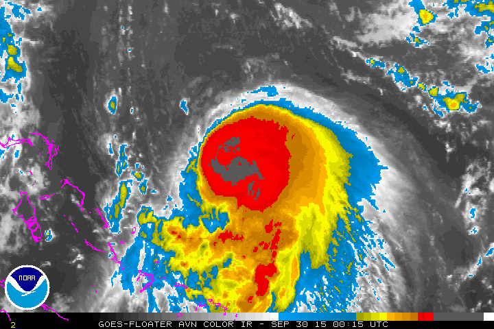
The symmetry is impressive. Will help it to continue strengthening. When was the last time we saw this east of the Bahamas?


0 likes
-
Aric Dunn
- Category 5
- Posts: 21238
- Age: 43
- Joined: Sun Sep 19, 2004 9:58 pm
- Location: Ready for the Chase.
- Contact:
Re: ATL: JOAQUIN - Tropical Storm - Discussion
Sorry for the crudeness of this just threw it together. but following the convective pattern last few hours and using microwave. this is the best estiamte on the center. roughly 25.7n 71.5 W

0 likes
Note: If I make a post that is brief. Please refer back to previous posts for the analysis or reasoning. I do not re-write/qoute what my initial post said each time.
If there is nothing before... then just ask
Space & Atmospheric Physicist, Embry-Riddle Aeronautical University,
I believe the sky is falling...
If there is nothing before... then just ask
Space & Atmospheric Physicist, Embry-Riddle Aeronautical University,
I believe the sky is falling...
-
TimeZone
-
northjaxpro
- S2K Supporter
- Posts: 8900
- Joined: Mon Sep 27, 2010 11:21 am
- Location: Jacksonville, FL
0 likes
NEVER, EVER SAY NEVER in the tropics and weather in general, and most importantly, with life itself!!
________________________________________________________________________________________
Fay 2008 Beryl 2012 Debby 2012 Colin 2016 Hermine 2016 Julia 2016 Matthew 2016 Irma 2017 Dorian 2019
________________________________________________________________________________________
Fay 2008 Beryl 2012 Debby 2012 Colin 2016 Hermine 2016 Julia 2016 Matthew 2016 Irma 2017 Dorian 2019
Who is online
Users browsing this forum: No registered users and 57 guests